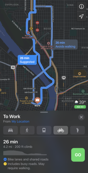
If you use Apple devices and rely on a bicycle to get around Portland, we’ve got some good news. Apple Maps has just expanded its cycling directions feature to our wonderful city.
Detailed cycling directions became available from Apple Maps back in September with the iOS 14 update, but it was limited to only a handful of major cities. Folks who updated their phones in the past few days in Portland were notified of the new feature.
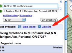
Apple is about 10 years behind Google Maps when it comes to offering bike-specific directions, but an initial look at their offering shows it might have been worth the wait. Apple Maps allows you to avoid hills or busy roads and prioritizes bike lanes and paths. It also gives users a clear idea of elevation gain, the need to walk up/down stairs, and other details.
Advertisement
The interface is very slick. Swipe up on the trip details and you see buttons for “Convenience Stores”, “Coffee” and “Bicycle Shop” locations. There’s also an option to provide turn-by-turn audio guidance. Another cool thing I noticed is little graphic that has air quality index (AQI) rating. The new cycling directions should go perfectly with an Apple Watch because you can just glance at your wrist to see where to go.
While Apple’s map app is beautiful, the directions given will likely take more tweaking to get just right. I tried my old office commute from Peninsula Park to SW 4th Avenue downtown. Apple Maps spit out two options, one on Vancouver Ave and the other on Interstate. It didn’t offer the main route I always took that uses the N Michigan neighborhood greenway. For more details, check this post on 9 to 5 Mac.
If you have an iPhone, give the new cycling directions in Apple Maps a try. For more on how they compare to Google Maps, check the video below:
— Jonathan Maus: (503) 706-8804, @jonathan_maus on Twitter and jonathan@bikeportland.org
— Get our headlines delivered to your inbox.
— Support this independent community media outlet with a one-time contribution or monthly subscription.


Thanks for reading.
BikePortland has served this community with independent community journalism since 2005. We rely on subscriptions from readers like you to survive. Your financial support is vital in keeping this valuable resource alive and well.
Please subscribe today to strengthen and expand our work.
Promising. I’ve been using the “Bike Maps” app the last couple years on my phone, and only use Google Maps when I’m on a computer.
I like the fact that Apple Maps appears to have some smarts about what is a safe route. Maybe it will be a little more discriminating in that respect than Google, which can be questionable when it shows a dashed-line route.
A failure for my route. It ignored the Lincoln bikeway which is almost a straight line from home to work and had me riding Division in the 50s and going north on 12th and turning back on to Division to get to 7th. A very dangerous route compared to the route I usually take.
I wonder if apple maps suffers from the same issue that google maps used to have in regards to diverters on neighborhood greenways. When routing me on Clinton, google maps would tell me to go a block down to Woodward and then back to Clinton to go around diverters, as if I was a car. Maybe apple will learn that diverters are permeable to bicycles over time.
This is true. Some of the tiny neighborhood connecting paths that you see in far SW Portland, near the Beaverton border, are there because I reported them as missing to Google.
I’m happy to see this as I don’t allow location services on any google apps.
I’ll wait.
I played around with this a bit recently. The routes weren’t great. It didn’t seem to know about bike lanes and other bike routes. Still, it’s good to have another option, and I’m guessing their directions will improve over time.
Taking another look, it seems to know about a lot of bike lanes, but not all. Going south on 21st over I-84, it recommends the “protected lane / bike lane” but then steers you onto 20th, which is busy and cramped.
That also means going from the protected bike lane on one side of the street to the other side of the street, which is particularly dangerous because of the curve right there.
It should have you stay on 21st IMO, especially if you’re headed further east.
It also claims the stretch on NE 21st near Weidler is a “protected lane,” which is incorrect.
For another point of comparison, I also saw recently that bycycle.org is still online and now uses OpenStreetMaps. The user interface isn’t as slick, especially on mobile, but it seems to be producing some decent routes.
I’m excited for this. I have an apple phone and watch. I much prefer to use apple maps because it buzzes my watch when I am coming up to an intersection where I need to change directions. Google maps does not integrate with the watch in this way.
I have had some issues with apple maps telling me to make illegal turns when driving in cars. I fear that it may do the same for bikes, as well, as others have noted. For instance, apple maps has tried to get me to turn onto Capitol Hwy when I’ve been traveling northbound on Barbur Blvd. This would be an extremely dangerous maneuver to try to pull off.
There are several other locations around Portland where apple maps has told me to make turns in locations where it would be illegal to do so. But google does the same thing. Both apple and google maps make it extremely difficult for users to submit corrections to street network data. Google only allows certain trusted individuals to make or suggest edits to the networks. I don’t even know if there is a process for requesting corrections to apple maps.
I thought I would try this out for a short ride on my way to a volunteer gig and it was a laughable fail. From NE Rosa Parks near MLK heading to NE 29th & Wygant, it told me to ride down MLK (!!!). FWIW, I rode Holman 🙂