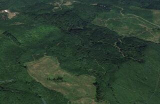
At the end of last month the Portland-based nonprofit Northwest Trail Alliance (NWTA) announced a groundbreaking partnership with Weyerhaeuser Company that opened up 3,100 acres of off-road riding just 14 miles from downtown. While still raw and relatively undeveloped, the Rocky Point Recreation Area is the best and most expansive place for mountain biking and gravel grinding that doesn’t require an hour-plus drive for Portland residents.
Since we posted our story at the end of July, NWTA’s lease has become effective and the group has released more information about how to access the area. In order to start riding and exploring out at Rocky Point, here’s what you need to know:
[icon name=”arrow-right” class=”” unprefixed_class=””] You must be a NWTA member in good standing. Membership plans start at $39 per year. You can join online here.
[icon name=”arrow-right” class=”” unprefixed_class=””] Once you’re a member, you and anyone else associated with your membership (like kids or spouses) need to sign a release of liability waiver.
[icon name=”arrow-right” class=”” unprefixed_class=””] Once you’ve got a membership and a signed waiver on file, you’ll need to get an ID band for your bike. You can pick those up at NWTA monthly meetings or at Fat Tire Farm (2714 NW Thurman St) or Cyclepath (2436 NE Martin Luther King Jr Blvd) bike shops. Why is this ID band necessary? “This is primarily a self-enforcement mechanism,” NWTA writes in a FAQ. “If someone is riding at Rocky Point without an ID band, they are either trespassing and putting your privilege at risk.”
[icon name=”arrow-right” class=”” unprefixed_class=””] Before heading out, be sure to check the current access status to make sure the area is open for public use (Weyerhaeuser has the right to close the site for forestry operations, high fire risk, and so on). (Also read the official terms and conditions of the lease while you’re at it.)
Advertisement
Getting there
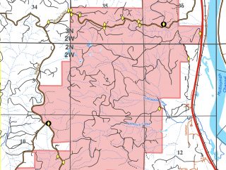
The parcel itself is about 5 miles long north-to-south. The closest access points are off NW Skyline Blvd about 1.3 miles north of the Logie Trail Road intersection (at what’s known as Cable Trail Trailhead on Google Maps). The main entrance as per NWTA is on NW Rocky Point Road about a mile up the hill from Highway 30 (map)
By bike:
Depending on the rider, it could take anywhere from an hour or two to get to the parcel by bike. Highway 30 is the flattest and most direct connection; but it’s also the loudest and most stressful. While there’s good reason it’s called “Dirty 30,” the highway isn’t that bad once you get north of Sauvie Island. Just be prepared for sections of narrow and debris-strewn shoulders. If you have the legs and the time, you can avoid Hwy 30 and take Skyline all the way, then drop down Rocky Point Road or pop into via any one of the Weyerhaeuser gates along the way.
By bus:
Public transit is an option. Service is limited, but it’s doable.
Put your bike on a line 16 TriMet bus, get off at Sauvie Island, and you’ll be only about 7.5 miles away from the riding area. Or you could try the Columbia County “CC” Rider line 1. This is part of the NW Connector regional transit service with service between Portland and St. Helens. These buses will carry your bike and there’s a Hwy 30/Havlik Drive stop that puts you just a few miles north of the Rocky Point Road entrance. The bus leaves SW Salmon between 5th and 6th nine times between 5:43 am and 6:39 pm and gets you to the Havlik stop in about a half-hour. Unfortunately, service is only available on weekdays!
By car:
Keep in mind there aren’t any parking lots to access this site. You can get directions to the main entrance on Rocky Point Road (which is just a gravel turnout) by entering these coordinates into your GPS machine: 45.696252, -122.882228. View the official map and look for parking at turnouts near the yellow diamonds (gates)
I hope this helps encourage you to get out there and ride!
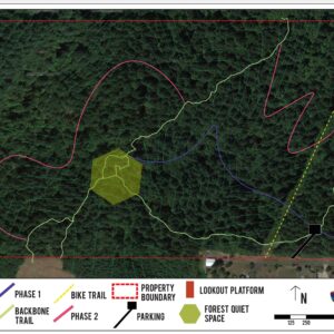
NWTA says a more detailed map of the bike trails and roads will be released soon. If you have any questions or concerns, send an email to rockypoint@nw-trail.org.
And stay tuned. I plan to head out for an exploration and will report back ASAP.
— Jonathan Maus: (503) 706-8804, @jonathan_maus on Twitter and jonathan@bikeportland.org
Never miss a story. Sign-up for the daily BP Headlines email.
BikePortland needs your support.


Thanks for reading.
BikePortland has served this community with independent community journalism since 2005. We rely on subscriptions from readers like you to survive. Your financial support is vital in keeping this valuable resource alive and well.
Please subscribe today to strengthen and expand our work.
I cannot wait to barrel through this area in my cargo shorts.
I’m more of a head-to-toe tie dye guy. Muted colors though. You know, you gotta blend in.
Sorry to be negative, but how long before somebody screws it all up for everybody else?
Have you ever made a positive comment in regard to mountain biking? Or maybe just a positive comment about anything?
It’s pretty amazing to see such consistently negative comments from a person. You should try being a positive force in something or, at the very least, let other people enjoy their lives without you detracting from it.
Dude, he’s honed his craft carefully for years. He’s BP’s most reliable character actor. He’s the Archie Bunker over here. You’re asking oil to transmogrify into water.
Fair. Makes me wonder where wsbob has disappeared to…it’s been nice not reading the same false comments over and over.
Also sorry to be negative, but Weyerhauser closes areas to recreation when there’s a danger of fire, meaning this area will be closed most summers in our hot, hot future. Enjoy it now, while you can.
That’s always been the case and this great news from NWTA doesn’t change that fact. The only difference is now the local mtb community will have the authority to enhance the already pretty damn good trails there. I’d also add that this will be an even better place to ride during the wet months with this agreement in place.
One interesting factoid about tree farms is that they are planted so densely that water rarely touches the ground even in a deluge. The increased fire risk from overplanted tree farms makes them great for riding during the winter months. The Rocky Point trails ride well even in the rain.
OK, let’s say I pony up the cash and join a club……
will the NWTA ( aside: I was involved in the transition from PUMP, waaay back . I tried like hell to get the name of the club to be Portland Off Road Navigators, but I just couldn’t get any traction. go figure) provide all members with a TRAIL MAP of this riding area? serious question. the “locals only” ethic has got to go.
NWTA says on their site that “The map will be updated with trail overlays soon, so check back for a fresh version.” I’m optimistic. http://nw-trail.org/trails/rocky-point/
You can also just go ride a bunch with a gps/ride app, then add the layers together. I haven’t been there in years, but could always *mostly* find my way around by memory after a few rides. I’m curious what it’s like now, as a lot of the trail area north of the road was cut a year or two ago, I believe.
Thanks for the good work NWTA.
I was wondering if there will be signage after the network is designed. Your best best is to contact NWTA or show up at a meeting and chat with some folks. The Board is incredibly approachable.
I don’t think it was a “locals only” ethic, but rather the directive of the timber company that no signs or maps be made. Doing so may have led to a total closure of the trails.
Is this the place in Scappoose that’s been around for years or is this a different piece of land?
@Dan, you are correct this is the Scapoose trail network.
it’s not clear here or on the nwta site _if_ the trails are seasonal or open year round! anyone have any insight here?
They are open year ’round, but some areas should definitely be avoided at times. The North side seems to hold up better in the wet months.