(Photo/video: Ted Timmons)
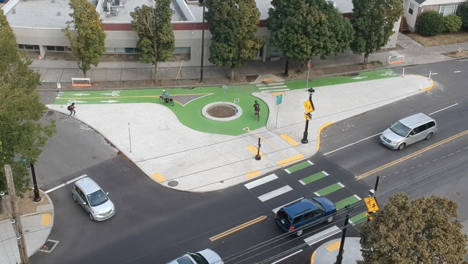
Our story about the City of Portland’s new traffic circle on SE Milwaukie and Mitchell spurred a robust conversation about its strengths and weaknesses. New drone footage (below) sheds more light on how it works.
Many readers feel the circle is over-engineered and circle portion is too small and narrow.
“Cyclists can easily handle navigating around each other,” wrote Clicky Freewheel, “all this roundabout does is limit the amount of space given to cyclists and creates a very tight turn for no good reason other than ‘it looks cool’.”
Advertisement
Oliver wrote: “Who’s in charge of this stuff? Stop making infrastructure to slow cyclists down, this is like the irritating 90 degree turns that are showing up everywhere.”
Others think it’s a major safety improvement.
“I live nearby to this and have ridden this section of Milwaukie to access the Springwater as part of my daily commute for over 10 years,” Otis chimed in. “While I agree the overall design has flaws, it’s a massive improvement over the previous scenario, and leads to a far safer crossing situation for most users.”
To help deepen our understanding of this new piece of infrastructure, friend of the blog Ted Timmons captured some excellent drone footage. It shows several people riding through the circle and approaching it from different angles. Hopefully the comment thread and this video give PBOT more solid feedback they can in projects going forward.
— Jonathan Maus: (503) 706-8804, @jonathan_maus on Twitter and jonathan@bikeportland.org
Never miss a story. Sign-up for the daily BP Headlines email.
BikePortland needs your support.


Thanks for reading.
BikePortland has served this community with independent community journalism since 2005. We rely on subscriptions from readers like you to survive. Your financial support is vital in keeping this valuable resource alive and well.
Please subscribe today to strengthen and expand our work.
Appears that cyclists take any way around the circle they please, some clockwise and others counter clockwise. The circle isn’t actually functioning as a circle. It’s just a big obstacle.
I’d like to see a little less “innovation” and a little more “equality” in our bike infrastructure — PBOT would never build a car intersection this way. In this case a triangle would work much better.
What about the 71 neighborhood traffic circles?
PBOT is planning two bike sized mini-roundabouts, on on NE 7th, and one on Tillamook, where cars have to squeeze around the circle designed for bikes.
Also, I think you mean ‘equity’ not ‘equality’.
Those are awful. Offal? Many car drivers don’t slow down appreciably. To often they either pass bikes aggressively before, crowd over in the pinch point, or tailgate and then pass aggressively afterward.
This is not a good way to sell bike circles by whatever name.
It seems a majority of cyclists did not use the facility as designers intended. Does that make it a design failure? I tend to think so, though compliance may improve over time.
My biggest complaint is that it was a much more expensive solution than was needed. We have so many locations where projects of more modest expenditure would serve far more users and solve more severe safety issues.
People are generally selfish, shortest safe path and all.
I say, no harm, no foul, but the smallness should be recognized as undesirable for just such reasons. This also looks a little ‘self-enforcing’ like speed cushions, where, the more traffic there is, the less people will try to circumnavigate the feature.
Huh, not a proper traffic circle at all with only two entrance/exits. And there is no transition for people that cross the street and turn left. I like the guy at the end that just stops.
This design has a whiff of “swing gates” about it.
‘proper’?
A ‘T’ intersection on a 1-way street can’t have a circular traffic control?
It’s almost as if they want to impede and slow bicycles, rather than cars.
SO MUCH CONCRETE
yeah…that’s one of my main criticisms of this facility. curbs would have worked well.
….or landscaping, trees, and/or stormwater facilities.
Portland taxpayers can’t afford to maintain the landscaping they have now.
Portland taxpayers can’t afford to maintain the roads they have now.
That’s a legitimate answer, and generally, I’d rather see most safety projects getting built without landscaping than not built at all.
On the other hand, landscaping could be afforded if money wasn’t going elsewhere. That’s especially true if you look at budgets beyond just PBOT’s. Many people seem to think we have a half billion to spend on freeway widening, for example.
Even on this project’s own budget, perhaps simplification of the turning circle or less concrete might have paid for a few street trees (installation and maintenance) on the island.
And the City requires landscaping on private property, and street trees, when private entities build projects. Claiming “it’s expensive” won’t get you anywhere.
Plus, the City is constantly claiming (with validity) that each street new street tree adds tens of thousands of dollars of value to the City. Why isn’t that true on its own projects?
False comparison. Federal highway safety funds can’t be used for such projects (or maintenance). The total cost of a freeway safety project includes local match and only the local match could be repurposed to other activities. Not even sure if the ‘local’ is Portland money or Oregon money, and ODOT is not yet in Portland’s camp regarding multi-modal safety.
Sure, but why do we feel the need to spend vast amounts Federal and state money on something like the RQ boondoggle and pretend like it’s only the local match we should care about? Federal & state transportation dollars take money away from other programs.
It’s not false at all. It’s the heart of the problem. We have lots of money for some things, but none for others that may be just as, or more, important. Priorities can be changed, and should be.
Sorry for being a yo-yo who now lives out of town, but where do the south-bound bicyclists go after they’ve crossed the crosswalk?
There’s a sign directing southbound cyclists to use the sidewalk, which is an atrocious slalom of utility poles and street signs bounded by a creeping wall of vegetation.
The alternative is to take the lane on SE Milwaukie for about 350 yards to SE Ellis, where you can peel off to the west and onto other southbound side streets. I did that the other day, and despite my generally high confidence taking the lane, I was gritting my teeth as cars anxiously crept up on my heels.
In short, there are no good options.
Or, go downhill to 17th where there’s a southbound bicycle lane that goes to Insley. That’s the connection to the 19th Ave neighborhood greenway.
True, but that generally works only if your destination is east of SE Milwauikie. If you’re going west to SE 13th, Sellwood Park, Sellwood Bridge, etc, then diverting (ba-dump-cha!) to SE 19th is a pretty roundabout (here all night, folks) way to get there.
https://www.portlandoregon.gov/transportation/article/666348
it’s like a bike couplet.
That intersection was previously a wide-open expanse of pavement. Narrowing the travel area for autos makes sense, so the outer edges of that concrete has some value. But as that video shows, the interior design leaves a lot to be desired.
I’m still stumped by green cross walks? Am I a vehicle that needs to follow vehicle laws or am a pedestrian? Green crosswalks put me into a limbo I do not enjoy.
get used to those green crosswalks. they are being used in many cities and it’s only a matter of time before they gain more formal recognition.
But they don’t mean much, do they. I mean, motorists aren’t required to stop for a cyclist in the green. Yet if you were to move a couple feet over to the white, they would be required to stop. Pretty silly if you ask me.
i treat them as if a motorist is required to stop and most of the time they do. i’m a huge fan.
Portland calls them crossbikes:
https://www.portlandoregon.gov/TRANSPORTATION/article/585677
You are a vehicle that needs to follow vehicle laws. The green “cross-bike” does not give you any legal protection like a white cross-walk does. You must stop and yield to crossing traffic. If you get hit by a car in the green zone you’ll most likely be found at fault. Then you’ll have to sue the city for creating that confusing situation.
i am most definitely not a vehicle.
i also believe that this kind of “confusion” is badly needed in our car-centric society.
You are not a vehicle. But your bike is.
True.
You’re an operator of a non-motorized vehicle.
only because cycling is not viewed as a legitimate transportation mode and, therefore, does not merit a separate legal definition.
My proposed definition, which I recently mailed off to the good folks at Oxford. I’m awaiting their reply.
Vehicle: a thing used for transporting people or goods, especially on land, such as a car, truck, or cart, except a bicycle, which is proper legit and thus merits its own definition. See bicycle.
i wonder whether riding a bike in the netherlands is legally equivalent to driving a “vehicle” — erm — car or truck…
It’s probably the same as here: in some contexts yes, in others no.
I think you have a good point. There’s a similar situation with standup paddleboards. When they came on the scene a few years ago, instead of viewing them as a distinct thing needing their own regulations, the Coast Guard deemed them “vessels” which meant they automatically became subject to the same regulations as boats, leading to a crazy hodgepodge of some regulations that are overkill, and others that lead to people drowning–all because people who wrote the rules for “vessels” never envisioned them applying to unsinkable boards with people standing on them. Nobody has ever written regulations specifically meant for standup paddleboards.
People riding bikes are doing something much different than driving cars or walking, yet unlike people driving or walking, they get saddled with rules and places to ride that were not designed well for them.
I mean soren has a good point.
I agree with Jered,
I would much rather all the green bike area’s be colored red, blue or maybe purple!
The Feds decide the correct color of pavement markings.
Also, damn, that’s a lot of concrete/impervious surface….how about some green-infra around that porkchop?
I like the porkchop! (operative city budget word: “pork”).
got any vegan options – bottle opener?
Landscaping is high cost ongoing maintenance Portland taxpayers can’t afford.
Road it last week and thought of the many other places that could use the excess amount of concrete that was used for this project. It reminded me of the facility on 28th/ NE Hoyt.
Is the dirt in the little circle there so a tree can be planted there in the future? They didn’t put any landscaping where it would be logical–in the expanses of concrete that also aren’t needed for sidewalk use–and then, in the already-constricted biking area in the middle, they shoehorned a circular planter into it.
It looks like half the concrete could have been (pervious) landscaped area. Even without that, it looks like several street trees (with all their associated benefits) could have been incorporated into the design.
I think dirt circle is supposed to be a blackberry patch… in a couple of years, it will serve to slow the bike traffic even more.
As someone who has only commuted by bike for just over a year, I think this is an improvement. I bike through this intersection to get to the Springwater trail on my way to/from work regularly and it used to always stress me out. I am not fast enough on my bike to be comfortable taking the lane and then making a left turn in the midst of 40 mph rush hour traffic on Milwaukie that, for the most part, did not want to stop for bicyclists. With the new green cross bike and the beacon cars actually stop to let you cross! I don’t mind slowing down to go through the circle if I know I can easily cross the street. Yes, the circle could have been larger and yes, it would have been better to just have a bike lane on Milwaukie on both sides of the street, but this is still better, imho, than what was there before.
who took those shots? Sellwood is in a clearly marked no-fly zone per most every air map for drone use.
I did. My understanding is that Sellwood is well outside the Class C airspace, which has a 400ft restriction from roughly Fremont south for a ways. Thanks for your concern.
This is at the north end of Westmoreland. Quite a ways from Sellwood.
Ted Buehler
Technically this is still Sellwood Moreland n’hood FWIW.
In the video it looks like ants versus cars!
Sellwood? I don’t think so.
So many neutral-colored cars in Portland. Black, white, grey, silver.
Don’t our alien overlords get tired of looking at all this blandness?
Bring on the General Lee!
(there’s actually one in SE somewhere, complete with Dixie horn)
I saw it last week, strangely enough. Notable enough that I pointed it out to the humans with me.
This is a huge dramatic improvement over the previous.
A traffic circle is a confusing, objectively poor choice.
/shrug/
Note the pedestrian crossing illegally in the lead photo.
Is it illegal? It looks like the person is going from the curved sidewalk in front of the curved building (he shows up at 0:30 on the video but there’s a tree in the way so I’m not certain he came from that sidewalk). So, he’s leaving a corner (but it’s undefined due to the curve) and crossing directly to the corner of the island. And while it seems the intent is that people should cross from the nearby curb cut to the island’s curb cut, that’s not a marked cross walk, nor is there any other marked crosswalk that would allow you to get to the island from the sidewalk the person left from.
Granted it looks like he’s transfixed by his phone and oblivious to everything around him…
If it’s not illegal, then someone forgot an ADA ramp.
A crosswalk is not the marking on a road, but a legal definition in the state statutes, which can be marked and other non-statutory locations that are marked. Unmarked crosswalks are the norm in Portland. The choice to put in ADA ramps is a grey area, but since the statutory crossing created by building the island is clearly not intended for pedestrians to use, due to all the other marked locations nearby, no ADA requirements are triggered.
I’m not sure what you mean by, “the statutory crossing created by building the island is clearly not intended for pedestrians to use, due to all the other marked locations nearby…” . It looks to me like the island is an integral part of the crossing path for people crossing from many starting points to many ending points, including the route the person in the photo is using.
In the case of that person, who’s stepping onto the northeast tip of the island, it looks to me like he’s taking an appropriate path if he started at the curved building/sidewalk at the north of the island, and is heading towards the sidewalk on the east side of Milwaukee. It may not be the path the designers anticipated him taking (I’d guess they’d want him to cross at the curb cuts) but he is going from corner of block to corner of island, and there’s no marked crossing nearby.
Interestingly, the diagram you posted: https://www.portlandoregon.gov/transportation/index.cfm?&a=666348 does not match what was built–it shows an additional marked crosswalk connecting the island to Milwaukee’s east sidewalk.
Would it be clearer if curb cuts were typically accompanied by marked crosswalks? As it is, curb cuts without markings signify “This is sort of where we want you to cross”.
The place the person is crossing constitutes a statutory crossing. The designers should have A) installed ramps or B) closed the crossing with signs.
Crosswalks are not required to be marked, since their location is defined by law, but ADA ramps at crosswalks are required as a Civil Rights issue.
Everyone should know crosswalks exist at every intersection unless closed by signs. Markings are used as reminders, especially in business districts, schools and high volume crossings.
I’m not sure this is correct: “Everyone should know crosswalks exist at every intersection unless closed by signs.”
What I recall is that if there’s a marked crosswalk nearby (within 150′?) then you have to use that one, even if there are nearby unmarked ones that are not closed by signs. If that’s true (but not at all sure it is) then if the curb cuts were connected with a marked crosswalk, the person in the photo should be using that. Not that anybody within the general public would ever know that except by chance.
The situation that I think is dangerous is when there are curb cuts at midblock that aren’t accompanied by a marked crosswalk. The person walking assumes they should cross there, but the person driving may not even notice the curb cuts, and not expect someone to be crossing at midblock. So the curb cuts make it more dangerous in a sense.
That also suggests that the paint does have a legal meaning, beyond just highlighting the underlying, pre-existing crosswalk. It also closes nearby unmarked crosswalks.
Yes (again if it’s true). I remember this being discussed in an article about people who painted a crosswalk near a daycare or school, after getting tired of waiting for the City to do it.
It brings up some issues. If one crosswalk is painted at a standard intersection, doesn’t that mean you can’t cross at the other two corners? So shouldn’t crosswalks at standard intersections typically be painted in pairs?
And the salmoning cyclist.
True roundabouts typically have splitter islands that direct/deflect entering vehicles in the correct, counter-clockwise path around the circular island.
How will the circles work with trucks? So many UPS sized vans/trucks on every street, pickups with long utility trailers, and 18 wheelers will keep driving around even if we wish they didn’t. If fancy curbs/landscaping will get runover then you haven’t planned it well.
paikiala
What about the 71 neighborhood traffic circles? PBOT is planning two bike sized mini-roundabouts, on on NE 7th, and one on Tillamook, where cars have to squeeze around the circle designed for bikes.<
Except in the most severely congested areas (possibly around PSU? Definitely around the University of Minnesota campus, which I recently biked across during the first week of school) devices like roundabouts shouldn’t be needed for cyclists. As has been amply pointed out above, we can usually negotiate around each other.
Ok, everybody, the design of this one is (sort of) specifically my fault.
I’m the person who came up with the idea to put a tree in the middle of that huge intersection. I had a vision of a mini-park-lett, with benches, and flowers and greenery all centered around a huge tree. I did a couple of google drawings and crayon drawings of how it would work and sent it off to Winston Sandino at PBOT. My design was little different (the triangle was supposed to occupy the northbound car traffic lane completely and route it around the park-lette, but it definitely had the big circle for the tree right in the middle.
The people at the city liked the idea of a tree in the middle, they took my idea, and came up with this thing.
Unfortunately, when our neighborhood association looked at it and gave the thumbs up , “Ok! we at least get a tree!” we did not understand from the overhead diagrams that the bike route would be completely hemmed in by concrete. That was a huge disappointment.
I’m glad it’s working. I hate how ugly it is. And I’m really sad there’s just a huge hole and still no tree.
Your version sounds great. I wish we could see your drawings. It makes me think that the thing that seems worst to me is all that land going to waste–basically an island of concrete cut off from all the surrounding buildings and sidewalks.
What I’d love to see would be your park idea, combined with eliminating the barrier created by the bike lane between the east sidewalk and the island. Imagine the bike lane raised to the sidewalk level, and the pedestrian-unfriendly pavers that are currently between the street trees replaced with regular sidewalk. That would mean the whole island would become connected to the sidewalk and accessible from the adjacent building. You could walk directly onto the island for its whole length–it wouldn’t even be an island anymore. As it is, the connection from the sidewalk to the island is a single, narrow, token crosswalk with curb cuts.
There are great examples of these types of spaces in cities everywhere. Portland seems to have a predilection for chopping spaces up and trying to tightly control and segregate each type of user, so all space becomes either circulation or leftover space isolated by circulation.
The question is, how much money was wasted on this project that could be used on others? It’s funny. The city uses tons of concrete when paint and posts would do it..but avoids concrete when it’s needed and puts down paint and posts.