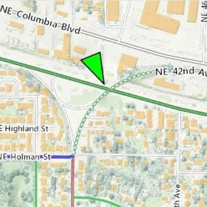
The best printed bike map in the Portland region will soon be a collector’s item.
Metro announced yesterday that they will no longer sell the printed version of the vaunted Bike There! map.
The map was first published in 1983 and has gone through nine major updates. The ninth (and last) edition came out in May 2015.
In an email to shops that stocked the map, Metro’s Marne Duke said the decision was made because of, “A combination of the decline in demand of printed maps and the increase in free map offerings from local cities and counties around the region.”
The news was met with disappointment by many of our friends on Twitter:
“Bummer. Finding this map at the grocery store was what got me to start biking in Portland.” — Nick Falbo.
“No! I am definitely of the era that loves a paper map.” — Mike Mason
“I don’t use apps or Google Maps or whatever. I like good old printed maps.” — Susan R
“Too bad. Printed maps are still useful for many bikers.” – alanshoebridge
Advertisement

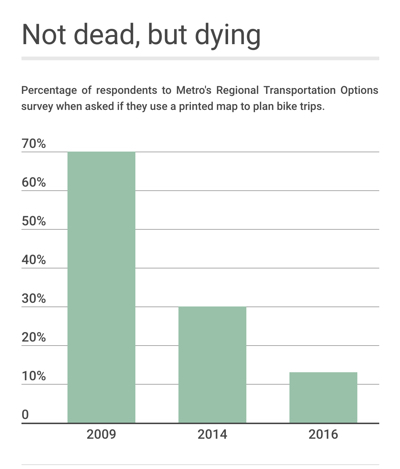
Metro’s Marne Duke said despite the love for printed maps, an overall decline in popularity forced their hand. After being left with a significant number of outdated and unsold eighth edition maps in 2010, Duke said they printed half as many (about 5,000) of the ninth edition maps in 2015. And surveys taken by Metro showed a sharp decline in paper map use over the past decade. 70% of respondents used the paper map in 2009, 30% did so in 2014, and just 13% of people reported using it as a way to plan their bike trips in the latest survey from 2016.
The printing, distribution, and marketing of the map also no longer pencil out. Duke said the ninth edition generated $10,550 in sales and cost about $25,000 to print and distribute. And that’s not including staff time.
Metro also once published the “Walk There!” book by Portland author Laura Foster; but that too has ceased production.
“With limited time and budget, an approach that focuses on expanding online availability that can potentially reach more – and a wider variety – of people was determined to be a better use of resources by our management team,” Duke says.
Moving forward, Metro will continue to beef up their online map and route resources and work to incorporate their datasets into the digital offerings of other local government agencies, app developers and mobility service providers.
If you want to grab one of the last remaining maps, check out this list of stockists on Metro’s website.
— Jonathan Maus: (503) 706-8804, @jonathan_maus on Twitter and jonathan@bikeportland.org
Never miss a story. Sign-up for the daily BP Headlines email.
BikePortland needs your support.


Thanks for reading.
BikePortland has served this community with independent community journalism since 2005. We rely on subscriptions from readers like you to survive. Your financial support is vital in keeping this valuable resource alive and well.
Please subscribe today to strengthen and expand our work.
But but but…what about resiliency?!…when a [ un-named] nation attacks the US with an EMP type weapon and all of our smart phones go dumb…how will I be able to bike-way-find my way to the nearest remaining Plaid Pantry …or relief center [that I do not know the bikeways to get to]?
It’s saving a resource and that’s good enough for me.
Don’t worry, when we get zapped with an EMP or the (more likely) we undergo catastrophic grid failure due to hacking, poor maintenance or sabotage, there won’t be much need for a map because auto traffic will quickly drop to zero due to gas pump failure or auto electrical failure. Then every road will become a bikeway, even the highways.
I wonder how DI2 shifters would be affected be EMP attack?
Failing that it would take out cell service and Waze, so pretty much everyone will focus on the road and primary streets. Those things alone…
…as for gas pump failure [at filling stations], I remember a nice trick that was all too common in the Philippines during power cuts…manually powering the pump flywheel inside the cabinet. Not so sure the “modern” gas pumps allows such a bypass…so best find an old service station to use or BYOP…bring your own pump to drop a line into the parking lot tanks…
Under the “safety” section in the online map, it says “front and rear lights are required…” but rear lights are not.
I have used my “Walk There!” book more than any book I have ever owned. I have found parks I would have never ventured off to.
I understand the reasoning behind the map’s retirement. Between Strava, Ride With GPS and a host of other electronic options,paying money for a paper (or tyvek as the case once was) map now seems almost quaint.
That said, I still use my most recent Bike There! map quite often, especially when taking visitors around town by bike. It’s a handy resource. I was honored to be on a redesign panel back in the day when an updated version was being created, and the time and talent that go into creating an accurate map should not be underestimated.
I guess I’m hanging onto my relic. Because this dinosaur doesn’t have a smartphone or GPS.
..::grin::..
Thanks for the link to Metro’s site. I have the Bike There! map in my BikeMaps app, but the latest version available in that app (as with most of the maps that app has, unfortunately) is from 2014 and out of date.