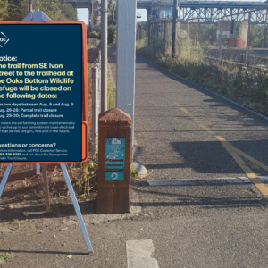
TriMet has just announced a temporary closure of the Springwater Corridor path:
TriMet and PGE have two upcoming improvement projects along the Springwater Corridor Trail that will require the temporary closure of a section of the trail, a Portland Parks & Recreation facility. For their safety, bicyclists and pedestrians will be detoured off the trail beginning Monday, Sept. 17 at 7:00 a.m. through Friday, Sept. 28. Trail users are encouraged to use SE Johnson Creek Boulevard and SE Tacoma Street between SE 45th Avenue and TriMet’s SE Tacoma/Johnson Creek MAX Station while the closure is in effect.
Advertisement
The closure will allow TriMet to improve access from the Springwater to their SE Tacoma/Johnson Creek MAX station. Plans call for a new stairway between the two that will be completed by the end of this year (although the path will only be closed through September 28th).
For their part, PGE will replace 12 utility poles that will be a big upgrade to power reliability and future-proofing energy supply for adjacent neighborhoods.
The two agencies have coordinated the 11-day closure to avoid having two separate disruptions to path traffic.
This closure will be added to the headaches of Springwater users who are already dealing with a major, four-month closure of the path closer to downtown Portland due to the Oaks Bottom Enhancement Project.
— Jonathan Maus: (503) 706-8804, @jonathan_maus on Twitter and jonathan@bikeportland.org
Never miss a story. Sign-up for the daily BP Headlines email.
BikePortland needs your support.


Thanks for reading.
BikePortland has served this community with independent community journalism since 2005. We rely on subscriptions from readers like you to survive. Your financial support is vital in keeping this valuable resource alive and well.
Please subscribe today to strengthen and expand our work.
When it rains on bikeways…it FLOODS. Too bad there is not some sorta coordination on the closure of important regional bikeways (aka Bike Highways).
..The coordination needs to be more holistic…detours and mitigations …versus just making the closure longer and thus worse. (Perhaps the next BP update will include any mitigations (free transit rides, detour sharrows, etc.)
PS. Has anyone asked (or reviewed the SEPA checklist) about the utility pole type and if they are wood…the chemical treatments proposed (checked the MDS sheets for conclusions on bio impacts)…just askin’.
Like both agencies working together so that there is only 1 closure instead of 2?
Well !$@# a duck. This is also on my daily commute as is what’s left of the northern part of the springwater- I can tell you from experience that detour suggested is very highly trafficked with downhill turns that, while the posted speed limit is 25, show a marked wear due to overlapping car, truck and small tank tires.
No thanks. I’ll find my own way. As always.
Also of note is that left hand turn to get back onto the springwater is across at least 60 ft of traffic clamoring to get on and/or off of hwy 99. To call it uncomfortable would be an understatement.
Here’s a detour that, if you’re not taking the sellwood bridge, is shorter, much lower traffic and far more sedate than the “oh let’s put them on the busiest road we can find with a bike lane”.
https://ridewithgps.com/routes/28553406
We cycled through the approaches to this area before and after the NABSA conference this week…saw the large detour maps BUT also saw a lot of cyclists lost and scripting their heads about where to go next.
Perhaps PBoT (etc.) needs to contact Google for a detour update for the bike layer and adding orange “detour sharrows” to redirect the cyclists.
Andrew…I hadn’t taken the time to look it up yet, but in my head was thinkingt Crystal Springs was going to be way better than staying on Johnson Creek. Thanks for sharing!
As someone who was out of town and just returned to find yet another closure on my commute, not sure why anyone wouldn’t do what I ended up doing: take the advised detour but just stay on Tacoma into Sellwood and then right on 17th or 19th if you’re headed downtown. Relatively straightforward. Same thing coming back from downtown, in reverse. Btw, was surprised how poorly signed that detour route was for the large Oaks Bottom project.
This stretch is open again as of the weekend, though work continues on the new steps near the Max station.