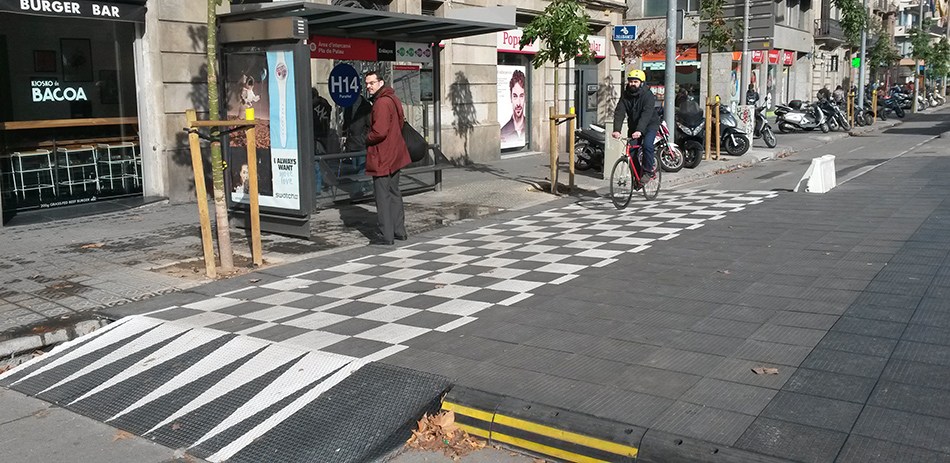
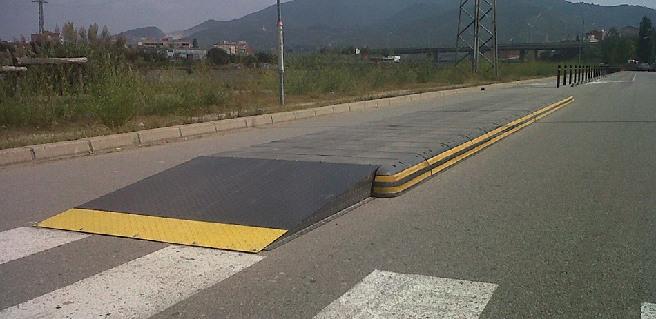
(Photo: Zicla)
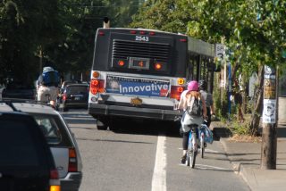
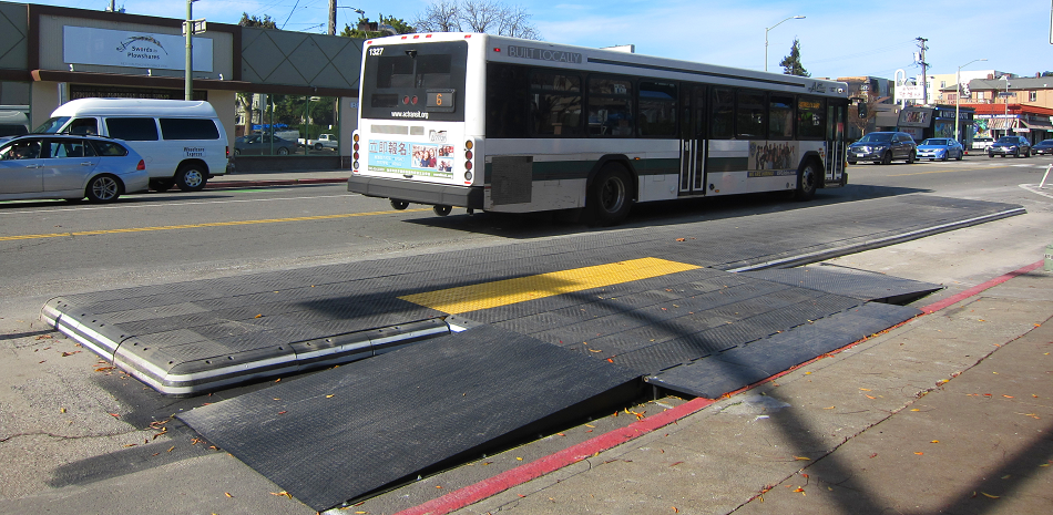
(Photo: Jonathan Maus/BikePortland)
On streets where buses and bikes are common, the “leapfrog” phenomenon has been a thorn in the side of the City of Portland for many years. It happens when a bus operator pulls all the way to the curb to service a stop — and temporarily blocks a travel lane used by bicycle riders. This behavior causes people to either stop and breathe toxic bus exhaust, or swerve around the bus into a more dangerous shared-lane environment. The issue has become more acute in recent years as the Bureau of Transportation has built more curbside lanes protected from drivers.
When a bus operator can still swing into a lane, it no longer qualifies as protected.
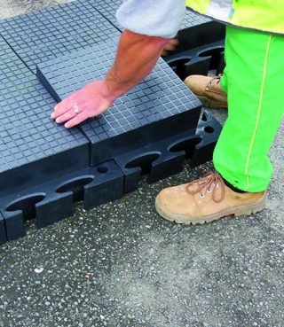
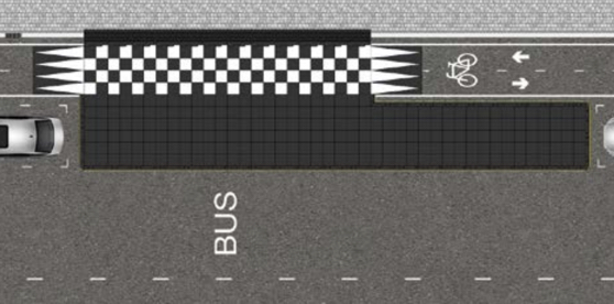
(Photo: Zicla)
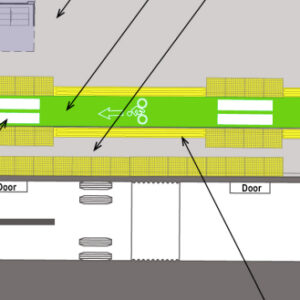
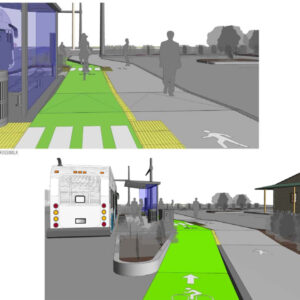
The solution is a bus island that provides a platform for passengers in the roadway (away from the curb) so it doesn’t block the curbside lane. The problem is, PBOT has been reluctant to install these in the past due to concerns about cost and a lack of confidence about the design and whether or not they’d work well for all road users. (Side note: The inability to solve the bus/bike leapfrog problem is one of the main reasons PBOT decided to shift the N Williams Ave lane to the left side.)
Now they’ve got a new plan: Yesterday PBOT staff working on the North Rosa Parks Way project told us they plan to install several pre-fabricated bus islands at select locations in the coming year. The islands would allow bicycle riders and other users of curbside travel lanes to continue through a bus stop while giving TriMet customers a platform to get on and off the bus. The islands will be purchased from a Spanish company called Zicla.
PBOT Project Manager Scott Cohen said two of the islands (dubbed Vectorial by Zicla) are coming to the southwest and northeast corners of Rosa Parks Way and Albina. Others will be installed on NW 18th and 19th along TriMet’s Line 24 and on the newly protected lanes on SE Morrison. The islands are modular and snap together “like Legos,” says Cohen. Cohen likes how the size of Zicla’s bus islands can be easily adjusted depending on the needs of a specific location. They’re made out of a recycles polyvinyl chloride (PVC) material which makes them relatively lightweight and durable in all types of weather.
Advertisement
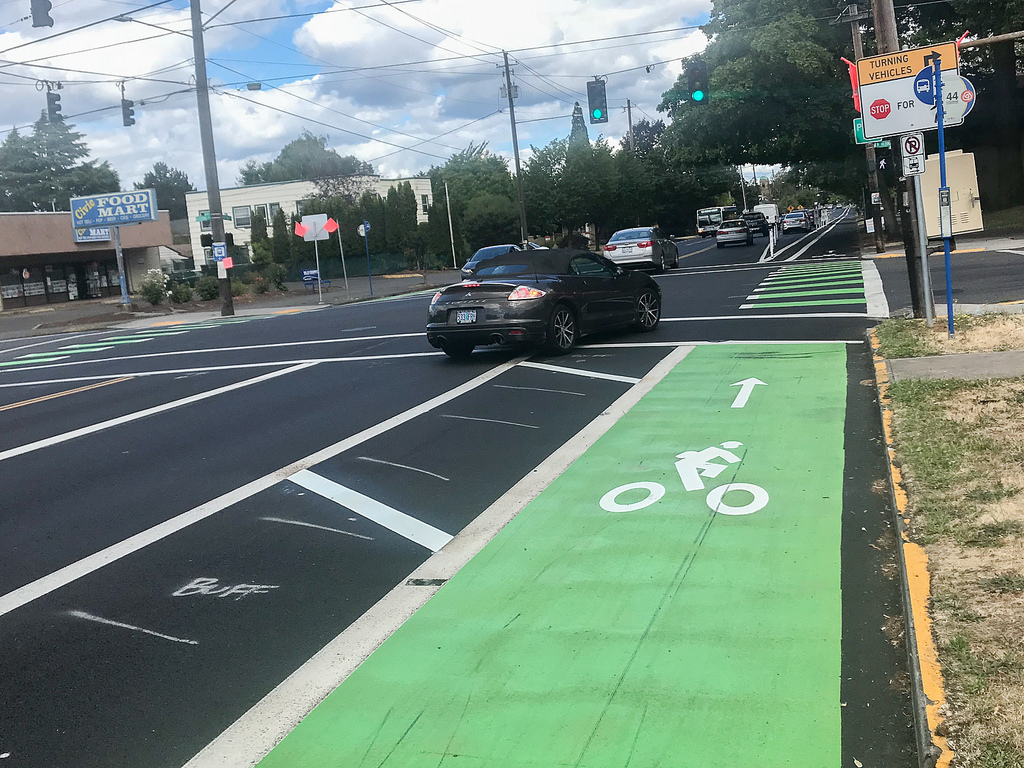
(Photo: Jonathan Maus/BikePortland)
Bus islands are common in major cycling cities like Amsterdam and Copenhagen (I saw them in action during a visit in 2013), and they’re beginning to catch on in the U.S. “We’ve talked to other cities including Los Angeles and Oakland; but it’s not an apples-to-apples comparison due to their weather,” Cohen shared. PBOT’s confidence in the Zicla product is based on how they’ve worked well in places with harsh winters like New York City and Pittsburgh. The use of bus islands in Seattle was listed by The Oregonian as one of 10 ways that city, “has blown past Portland in transportation moxie.”
Bus islands aren’t completely new to Portland, but they haven’t been adopted on a large scale or used on a busy thoroughfare. Our best example of one is on SW Moody just south of Gaines. Local tactical urbanist group Better Block PDX also gave us a look at a bus island during their Better Broadway demonstration in May 2016.
Cohen says the islands PBOT plans to use will require lane users to roll up and then down the bus platform. This ramp will likely address one of PBOT and TriMet’s main concerns with this type of design: getting bicycle (and scooter) users to slow down as they pass by bus passengers.
The cost of each island will range from $20,000 to $50,000 a piece depending on size. Once they are installed, we can expect them to be in place for several years while PBOT looks for funding for more permanent capital improvements. In the meantime, TriMet is developing a bus island as part of their Division Transit Project that they say could become the citywide standard.
Cohen says the islands will be installed by next spring.
For more about Zicla bus islands, read about their use in Oakland, New York City, Pittsburgh and elsewhere via this March 2018 Streetsblog article.
— Jonathan Maus: (503) 706-8804, @jonathan_maus on Twitter and jonathan@bikeportland.org
Never miss a story. Sign-up for the daily BP Headlines email.
BikePortland needs your support.




Thanks for reading.
BikePortland has served this community with independent community journalism since 2005. We rely on subscriptions from readers like you to survive. Your financial support is vital in keeping this valuable resource alive and well.
Please subscribe today to strengthen and expand our work.
The new protected bike lanes on NE Halsey / Weidler and NW Front, both of which should complete by next year, will include concrete bus islands. That will offer a good way for TriMet and PBOT to compare the two approaches.
When did NW Front become a protected bike lane? Bike Portland’s article form last year indicates a painted, buffered bike lane.
The project evolved a lot, for the better, since that article was published. You can view the finalized drawing set here:
https://procure.portlandoregon.gov/bso/external/bidDetail.sdo?bidId=00000944&parentUrl=activeBids
That’s awesome!
This is awesome 🙂 I was not aware of it!
Do you have any updates on the crossing of Naito at Flanders? I recall I heard about it first from you via a tweet or comment here!
I haven’t seen any recent drawings of Flanders, but PBOT is doing a work session with the neighborhoods on Sept 20th to discuss the non-bridge related aspects of the bikeway project, so there should more revealed then.
Excited that the city is trying these out. I hope they make them very visible to people biking and driving as they approach the bus stops.
unfortunately, from the pictures it looks like they blend in just enough that many drivers will run right into them trying to make a right turn and the people waiting on a bus could just be sitting ducks.
The photo of the boarding island in Oakland shown in the article was during the installation, not yet completed. Here’s a video of the finished installation, with striping and bollards that help make it more visible.
https://twitter.com/OakDOT/status/1026268160029118464
thanks Robert, that is such a great video. This looks promising
Rode up Ladd St from Hawthorne to Division this week and encountered a long line of standing buses (2 x #10) and cars (more than 20) on Ladd St waiting back from the light at 7 corners to cross Division. Both buses had stopped so close to the parked cars on the street curb that there was no room to pass this line of stopped vehicles on the right (give us a break!), and the left side of the car line was a squeeze and quite a distance to salmon against on-coming traffic to get up to the green flag painted at the light. Lack of any driveways along here make it more challenging to get onto the sidewalk, also. Is this street no longer a major biking thoroughfare? Seems to be given over to autos and buses from the circle to seven corners. That line of cars was at least 3-4 light cycles long, so I can’t imagine waiting in that line with the bus exhuast. How do other cyclists deal with this – have most found a new route? The new speed bumps on Ladd St are also pretty steep for a bike.
16th also passes through Ladd’s circle and connects Division and Hawthorne.
But I dunno — if you find the Lad St. speed bumps daunting, you may feel the same about the cornering to get around the rose gardens on 16th.
Speed bumps that are too steep for a bike?
Many don’t have a smooth transition.
We’ll see if they are steeper than the bus island platforms you’ll have to ride over on Rosa Parks. But, probably less slippery when wet. And probably longer-lasting before they start to degrade, detach, or slide around.
Yeah, the speed bumps are terrible. I leapfrog buses as they drive since they’ve been added. I’d love to see the buses find a different route rather than cutting through Ladd’s. Nothing screams an improved greenway then a bunch of buses. ♂️
I encountered this just yesterday. I rode the last bit on the sidewalk then came back to the road at the green paint and the bike box.
Yes, this intersection/route is very poor. I find that I used to ride it with my kids after school to avoid the SE Harrison hill. When there was construction blocking the bike lane entirely it was a nightmare. Once, a bus gassed it and drove on the other side on the island to pass us, only to stop at the light when we rolled up next to it. We now go through the neighborhood up to Hosford school on residental roads not bike routes. Too many cars, too many buses, too much exhaust. Poor bike route.
I love this idea, I hope these are sturdy enough that they can be reinstalled after being replaced with permanent floating bust stops. I would like to know more about their slipperiness, how they drain stormwater, and if there are more robust markings (like a guardrail) to improve the visibility of the curb between the bike ramp and the travel lane
Bus islands are a great solution to the “leapfrog” issue, but they can introduce a new problem– impaired visibility. Check out this animation that was created during the N Williams Ave. process:
https://youtu.be/Ao5XP77jEMc
When a bus stops at the island, all visibility between a bicycle rider and cross traffic coming from the left is eliminated.
The proposed test side at N Albina and Rosa Parks should not experience this issue unless someone chooses to run a red light. However, if a bus island is considered for an non-signalized intersection, reduced visibility is a major concern. Moving the bus island to the far side (North of the intersection in the example provided above) would help.
This has the additional benefit that far side bus stops are considered best practice for efficient bus operations. https://www.citylab.com/transportation/2016/03/the-best-place-for-a-bus-stop/472188/
I wonder if far side bus stops wouldn’t tend to result in following cars getting stuck blocking the intersection. How about mid-block bus stops?
Anyway, I’m happy to see the city trying these.
Mid-block bus stops can create problems for bus passengers crossing the street. Bus stops need to be near crosswalks.
Yeah, I’ve definitely had this issue happen once in Seattle at the bus islands on Dexter. In general I really love bus islands but the ones near intersections can be harrowing unless cyclists slow down. I’ve also had the problem of cars not seeing me behind the bus island and right hooking in front of me.
In DC, FWIW, it’s illegal to pass and turn across a bus stopped at a bus stop–the intent is of course to prevent people who’ve just gotten off the bus being hit, but it’s handy as a rider in the situation you describe as well.
[DC Code § 50–2201.29, Bus right-of-way at intersections: https://code.dccouncil.us/dc/council/code/sections/50-2201.29.html%5D
(That link of course shouldn’t have had the bracket attached to the end: https://code.dccouncil.us/dc/council/code/sections/50-2201.29.html …)
This is exactly right. As others have suggested, the best practice is to locate on the far side of intersections.
Bus islands work great if designed properly. Implementation must consider the needs of all users, especially ADA. The up and down from sidewalk to bike lane to island can be difficult for certain users.
The streetcar stop on Moody fails miserably in this manner as the curb cut doesn’t even line up with island entrance. However, the Vancouver examples referenced in this thread are outstanding.
The pre-fab bus islands that have the bus island, bike lane, and sidewalk at the same grade often only have tactile warning strips between the bike lane and bus island, however, they are also needed between the sidewalk and bike lane.
I’m eager to see this. I had a very near right hook at Rosa Parks and Albina recently, when someone swerved around a parked bus to make a right onto Albina as I was walking through the intersection. She didn’t even see me, or my two daughters as she drove 40 mph 6 inches in front of us. It was really terrifying for all of us. Hopefully these islands will reduce that sort of dangerous driving.
It would be nice if buses had designed areas where they can wait that has the least effect on active transportation… I’ve seen bus drivers do some dumb things such as sticking their tail ends out and then taking their break or waiting at a place to catch up with the schedule. Also, it would be nice to see a law or an enforcement of a law where drivers can’t turn right in front of a bus
Waiting at a stop, in some cases, is normal bus operation. It may be dumb but the driver is required to do it if the bus is ahead of schedule. Hopefully the timing points have a pullout. We don’t make room for buses on our streets.
Here is an example of a more permanent bus stop from Copenhagen.
https://www.youtube.com/watch?v=Nmc41cGYDC0
Vancouver, BC has had them for years.
https://goo.gl/maps/pqfLgzRaULS2
TRIMET/ PBoT, great to hear this. I have used this treatment extensively in the NL. (I hope that C-TRAN/CoV considers this as part of the protected 2-way bike track now in design for East McLoughlin (E. Reserve to Mill Plain).
Though I have one comment for PBoT / TRIMET – in my experience, the use of “temporary” rubber type street devices tends to cost as almost as much as just doing it out of asphalt and pre-fab concrete curbing, in one includes the purchase price of the rubber device. The value of “reuse” just never panned out for our pilots.
I hope those quarter-round ends of the bus passenger islands get some better visibility treatment (planters with flowers?). I could easily imagine a time when there are not parked cars there and a person (probably on a bicycle, probably at night) crashes into the end of the island.
I agree that these need to be much much more visible at along the all of the edges. The dark color will really make them disappear at night. In addition to white or yellow retro-relective coating, perhaps bollards or other legally allowed vertical elements can be added.
It’s hard to tell from these pictures (linked below), but in Vancouver, BC we have a bus island like platform on Dunsmuir St at Cambie. This is a protected two way bike lane and where the bus stops the protection from curbs changes from jersey barrier / curb & planter to a wide flat loading area for passengers. People waiting for the bus generally stay on the sidewalk until the bus pulls up then they cross the bike lane in the striped crosswalks.
https://goo.gl/maps/hpzdgMke7kF2
https://goo.gl/maps/omnNGjN1ku42
I know the situation here on Rosa Parks (and other spots) is different, but thought the regional example was worth adding to the mix. Vancouver, of course, has very similar weather to Portland, and this style does not require a super massive concrete build.
The “leapfrog” phenomenon has come into being because a bus driver is driving a large vehicle, and has to maneuver it to get close to the waiting passengers at a bus stop, some of whom may be elderly, etc. and need to be serviced by moving close enough.
A conflict between pedestrians, and cyclists on one hand, and cars and buses on the other hand, has been existing for long, everywhere. Accidents happen when one of these two parties thinks they own the common place and ignore the other, at a grave cost. These bus islands would force the bus-drivers to keep off at a safe distance, with a barrier-island separating the bike-lane and the buses.
Well, looks to be a feasible solution. But as pointed out, how about the new kind of accidents happening at night when it is also raining, and the light becomes very poor. The new bus-islands look ‘chic’ and painted well in yellow color, but this contrast will wear off with time. The light can be so poor that a bike-rider can miss the edge of his bike-lane, while going up the slope, and get hurt badly. And chances of this will be more since bike-readers will become complacent that they have no fear of an intruding bus.
This is not to say that the current behavior of bus-drivers to ‘encroach’ on the bike-lane when they find convenient, is legitimate and should remain as a permanent fear in the minds of the bike-riders. And similarly, why should the waiting bus-passengers be watchful of passing bikes all the time? And with the intervening bus-island in place, should the waiting bus-passengers stand and wait in the open on these bus-islands, if they have to avoid the passing bikes on the bike-tracks. How about old passengers who need to sit at a bus-stop, or, any bus-passenger needing to sit in the bus-shelter when it is raining?
Are we not creating a new rift between the bike-riders and the waiting bus-passengers, just to mitigate the conflict between the ‘right of way’ of the cyclist and the arriving buses? And have we not added an additional barrier in the smooth passage of the bike-riders by sloping their tracks, up and then down, even though just a few inches, at each us-stop? Don’t they deserve a smooth track, without the intervening slope-ups and slope-downs?
Why can’t the rectangular space to be occupied by the bus-island, be barricaded by bollards, or plastic traffic barriers in a manner that it becomes impractical for the incoming bus to be driven onto the bike-track, which is the root cause of the problem? But then, one can ask that the bikes will zoom past, into the boarding or alighting bus-passengers, if the bike-lanes have no up- and down-slopes. Perhaps the only solution maybe to have raised bike-tracks, say about 10-12 feet high, like the pedestrian sky-walks, with option for bike-riders to get ‘on’ of ‘off’ them at designated places. It looks to be a unusual solution, and perhaps expensive to construct, but absolute safety always comes at a price!
What happened to “next spring”?