“We understood that this was more forward momentum than we have seen in many years.”
— Jim Sjulin, 40-Mile Loop Land Trust
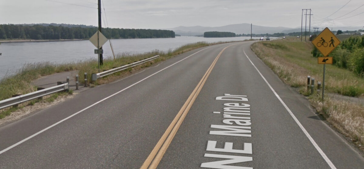
Marine Drive is a gem in our cycling network and a thorn in our cycling socks at the same time. For as great as it is in some spots — and as valuable as it is as an east-west connection between St. Johns and Troutdale — it remains neglected and riddled with dangerous gaps that prevent it from being a truly great route for cycling.
If you love/hate riding on Marine Drive, we’ve got two bits of great news: There’s a new advocacy effort afoot to close the gaps, and the City of Portland has just put real money on the table to close a few of them by next summer.
First, remember the name Jim Sjulin. Now retired, he’s the former natural resources director for the Portland Parks & Recreation bureau. These days Jim is a volunteer with the 40-Mile Loop Land Trust who’s spearheading an effort to complete the Marine Drive Path — which was the first project the organization worked on when it was founded in 1982. We recently connected with Jim via email to learn more about this exciting news. “When we [40-Mile Loop] recognized that we were about to lurch from 74% completion to 87% completion in 2019, we understood that this was more forward momentum than we have seen in many years,” he shared. “To take advantage of the momentum, we are trying to push what can be moved.”
Jim has put together an impressive, 137-page presentation that documents the entire route from Kelley Point Park to the Sandy River. It gives us a complete inventory of the remaining gaps and explains what it would take to fill them. Some just need funding, others are more complicated. Atop their list is the gap between I-205 east to 122nd. Closing that gap, Jim says, “Would mean that we would have a continuous off-road [paved] trail from NE 33rd Drive to the I-84 Bridge over the Sandy River, a distance of over 14 miles. Not only that, this continuous section of Marine Drive Trail would intersect with the 18.5 mile I-205 Path (Vancouver to Oregon City) which, in turn, intersects with the Springwater Corridor and the Eastbank Esplanade.”
Work by Jim and others at 40-Mile Loop is beginning to pay off.
Earlier this month, the City of Portland announced $1.7 million in funding for a project that will add a buffered lane and other safety upgrades between I-205 and 185th.
Advertisement
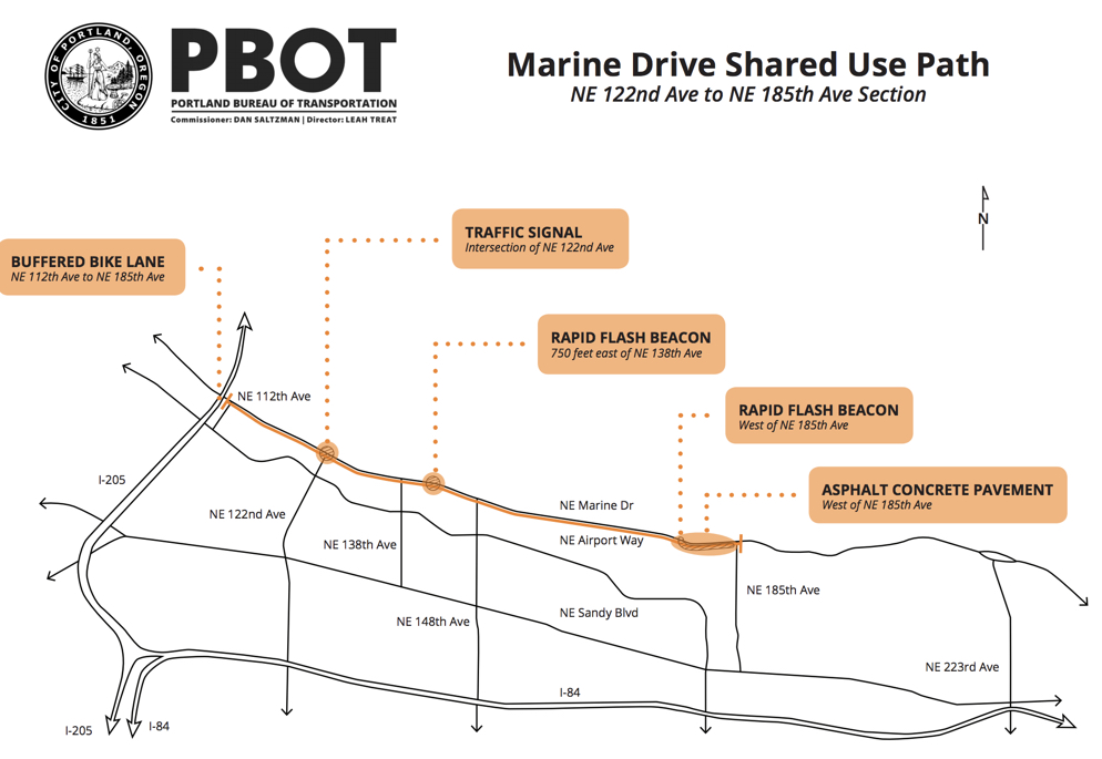
With $589,000 in Parks System Development Charges (supported by Commissioner Amanda Fritz), $50,000 from the Bureau of Transportation’s Vision Zero program (Marine Drive is listed on their High Crash Network), and a $1.1 million federal grant (via Metro Regional Flex Funds), PBOT plans to redo the lane striping to provide more room for cycling on this 3.7-mile stretch of the roadway. In addition, they’ll install a new traffic signal at 122nd (site of many collisions), add rapid flashing beacons where the path crosses the roadway east of 138th and west of 185th, and repave the existing path west of 185th.
PBOT says construction is due to start early 2019 and should be completed by next summer.
For Jim Sjulin and the 40-Mile Loop Land Trust, the work is just getting started. They’ve already been meeting regularly with PBOT, Parks, Metro, the Port of Portland and city planners in Troutdale, Fairview and Gresham. Now they’ll move into a public outreach phase and look to connect with neighborhood groups.
Get involved and learn more by emailing info@40mileloop.org, visit their website, or connect with them on Facebook. Also don’t forget to put Metro’s Quarterly Trails Forum on your calendar. The event is a perfect opportunity to connect with advocates and agency staff working on this and many other regional projects. The next one is on October 24th.
— Jonathan Maus: (503) 706-8804, @jonathan_maus on Twitter and jonathan@bikeportland.org
Never miss a story. Sign-up for the daily BP Headlines email.
BikePortland needs your support.



Thanks for reading.
BikePortland has served this community with independent community journalism since 2005. We rely on subscriptions from readers like you to survive. Your financial support is vital in keeping this valuable resource alive and well.
Please subscribe today to strengthen and expand our work.
I clicked on this with excitement, hoping it would be the gap I interact with most, between Delta Park and 33rd Drive. Though there’s a “bike lane” through that section, it’s crazily overgrown and very narrow in spots, making the fast truck traffic even scarier. Worst of all is the huge fields of apparently unused space to the south of the road (I get that it’s probably airport security stuff, but still). Maybe this section could be next?
I was going to make this very point. Completion of the Columbia Slough Trail between N. Vancouver and Marine drive along the Peninsula Drainage Canal would be the connection I’d like to see most.
I’ve taken to riding Vancouver/Gertz/13th as a way to avoid much of that section, but Dancing with Fedex in the narrow, dark tunnel on Vancouver Way beneath MLK is what I like to call “exciting”.
A great (and low-cost) interim fix would be to get a scraper out there and remove the tons of sand/gravel that has accumulated along the guardrail over the years there that is encroaching on the bike lane.
If it’s overgrown, contact 503 823 SAFE, they tend to move quickly on that stuff in my experience.
I hope that the route gets these improvements.
That said, I’ll share here what I told the project advocates when they came to EPAP to ask for our support:
The Marine Drive bike route improvements are nice, but they do nothing for East Portland because we can’t get to Marine Drive. Between I-205 and the city limits, *ALL* the possible N-S routes that connect to Marine Drive are harrowing for bicyclists.
This will sound greedy, but the current separated bike path is really not up to snuff for road training, which I bet is the bulk of what gets cyclists out to Marine Drive. It would need to be wider, straighter and smoother to take a paceline down there. Until then, I am most likely to ride Marine Drive cowering on the shoulder.
I don’t think I’ll ever expect our Multi-Use Paths to be good for road training. That’s just not what they’re for.
Yeah no thanks. It’s hard enough getting my wife out on a bike without some Tour de France wanna-be buzzing us.
I agree. Given that the overwhelming majority of people riding on Marine Drive are road cyclists–particularly east of 205–having facilities conducive to road cycling is entirely appropriate.
The MUP is hugely problematic, moreover, because it requires cyclists traveling east from 33rd to cross Marine Drive four times and those doing the reverse to cross twice; in my view, those crossings are by far the hairiest part of the Marine Drive experience for cyclists.
I’m a bit confused as to why this is an improvement. The City will provide a “buffered bike lane” on a Hwy next to 45+ mph traffic? Would it not make more sense to pave the trail gap from 112 to 122nd? How is this a good decision?
I agree. If all they’re doing is creating a buffered bike lane along this treacherous road, rather than filling the short remaining gaps in the multi- use trail, that seems like a bad plan… and could that really total $1.7 million? How come Gresham, Troutdale, Metro, and the Port of Portland have all gotten their act together to fill major trail gaps in 2019, but not Portland? Can any PBOT folks chime in to clarify?
8 to 80? Interested but concerned? I think not.
Pig. Lipstick. That is all.
i agree. A paved path would be much better. But as always, these projects can only accomplish as much as the politics and funding allow. We need to keep pushing PBOT to do more here and let’s make sure we support 40-Mile Loop’s advocacy work.
The intersection of 33rd and Marine really needs a sensor-and-button activated signal. It is possible to wait a very long time on 33rd trying to turn left onto Marine.
I would argue 33rd needs a full traffic signal just as much as the other crossings like 122nd that are getting them. Definitely a safety issue, and it should fall under the HCN project.
Agreed. That turn from Marine to 6th is no joy either…
If I understand the proposal a new path would run to the west starting at the existing 33rd underpass and obviate the need for turning left onto Marine Dr from 33rd. The presention says the Port of Portland owns the land where the path would go, but portlandmaps.com lists Sunderland Association of Neighbors. Regardless, it seems hacking in a dirt path would be an easy initial start. A crossing would still be needed where the path would join Marine Dr by the golf course, but it could be handled with a flasher.
I’m confused by this information. My understanding was that the city has approved/ funded filing some crucial gaps in the multi-use PATH, in *addition* to the new signals & RRFBs and widening bike lanes on Marine Dr. in other sections where levee reconstruction would need to be done before the path can be built. Jonathan, can you clarify? Is PBOT going to do both things simultaneously?
Also, on PBOT’s HCN website, it says this work will be completed in 2018. Has it been pushed back yet again? If so, anyone know why?
Hi DSKJ,
All the project elements in this post will be done simultaneously. As for the timeline… It’s so common for them to be pushed back. It could be any number of things. One variable that will always loom over Marine Drive projects is the fact that it is on federally-regulated levee propery so there’s an extra layer of red-tape to deal with.
Thanks for the context. I probably should’ve made my question clearer: didn’t this project somehow morph from PBOT filling the gaps in the MUP to just adding the wider lanes/ shoulders (plus the new signals) ? I pretty clearly recall that city council funded closing MUP gaps. Any knowledge/info on the back story here?
Very happy about the signal at 122nd. Way overdue!
They announced these improvements long before I left town in 2015. Why the delay?
David, the way this city has degraded you aren’t missing a thing.
Well it’s the start of something but agree with previous posts. Finally on the signal at 122 it’s been needed for years. Totally ignores 33rd intersection & anything west. Nothing is mentioned to reduce speeding now that everyone is using as a shortcut. Out near Troutdale there is a sign posted for 55 mph. Somewhere it’s supposed to drop to 45 mph but no one ever does nor is it enforced. Twice in the last month I’ve pasted by overturned vehicles lying off the enbankment on the north side of the road. One the fire department just finishing the cleanup & reopening the road.
As a woman who cycles alone I do not use the paths that are below the road where I cannot be seen especially on the vegetation north side near 122 & Marine Dr (dangerous to get to anyway) to vulnerable to being assaulted or having bike grabbed unprovoked (this has happened).
What do you think of the proposed Sullivan’s Gulch trail by I-84 and the light rail line / freight rail road?
And while we’re at it: Why on earth can’t PBOT and Parks & Recreation find the will and the funds to complete the measly 0.38 mile to link the path to Kelley Point Park?
Another fatality on Marine Drive.
https://katu.com/news/local/police-one-person-killed-in-crash-on-northeast-marine-drive
Good grief. This is horrible. : (
Few weeks back a friend I was zipped by a fast moving semi truck it came inches from our bars. 🙁 love the area but its nerve racking.
I rode 33rd then Marine Drive and I-5 to work in Vancouver regularly for some time. In the daytime, I don’t find riding on the shoulder of Marine Drive to be too daunting. You use a mirror to monitor vehicles coming up behind you; you observe that the semi-truck drivers are professional, they know you are there, and will pull as far to the left as they can; and you realize that when the semi-trucks pass closer than ideal it is because they simply don’t have any more room. It is really the passenger cars you need to watch out for, in your mirror.
In the dark or fog, though, I’m not a fan of the Marine Drive shoulder. Of course you’ll be riding with really good lights and reflectives – being a ninja here is really reckless – but at night it is harder for drivers and cyclists alike to see or judge distances, so the situation moves past my personal comfort line.
Overall, wider shoulders/bike lanes separated from the traffic lane with rumble strips would be welcome here. There are a few spots where roadside parking could be prohibited, to allow more room for bikes. Better vegetation trimming would help. I also agree that a bike path/MUP could be built on the south side, but I’m not sure how to best handle where that path would cross over Marine.