(Photos by J. Maus/BikePortland)
Marine Drive is a valuable gem in our regional biking network. Its combination of off-street paths and bike lanes make it an excellent way to connect to Troutdale, the Sandy River, and the gorgeous roads in around the Columbia River Gorge.
Unfortunately, the route most people take from Marine Drive through Troutdale to the Historic Columbia River Highway is a real pain. For years I’ve ridden through that section by going under I-84, then riding a sketchy bike lane adjacent to a huge truck stop and the busy driveways of shops and fast food joints. Now, thanks to a mix of old paths and trails (forgotten sections of the 40-Mile Loop), combined with a recently completed Oregon Department of Transportation project, there’s a much better way to make this connection.

And if you’re open to a bit of dirt and adventure, you can extend the fun riding possibilities even further. I recently did some exploring and found a great route between the Historic Highway and Marine Drive that allowed me to completely avoid Troutdale and the I-84 freeway on-ramps and enjoy some quiet and peaceful paths and trails.
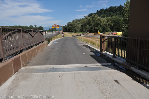
The big catalyst in this connection is ODOT’s recently completed update to the I-84 bridge over the Sandy River. As we reported last summer, that project added a new, physically protected biking and walking path to the bridge. What I recently discovered is that there are now a host of new paths leading up to the bridge.
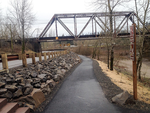
Let’s begin on the Historic Highway, east of the Sandy River just outside Troutdale. Instead of taking the bridge (west) back to the main street of Troutdale, continue north on the highway toward Lewis & Clark State Park. Eventually you’ll see a new path along the river. Take that path (being cautious and considerate of walkers) and it will lead you right to I-84. If you stay to the left (west) you’ll get up onto the new bridge path.
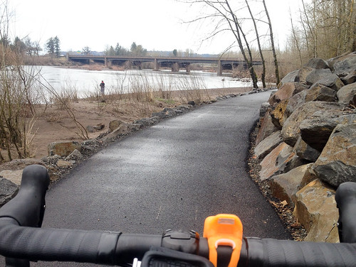
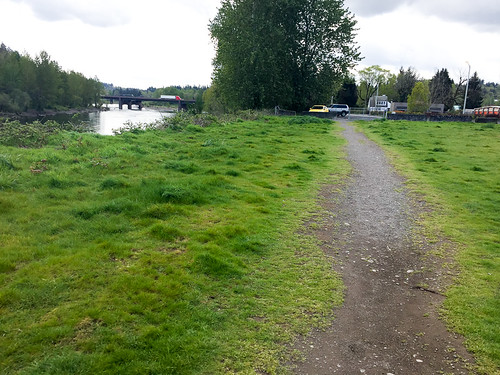
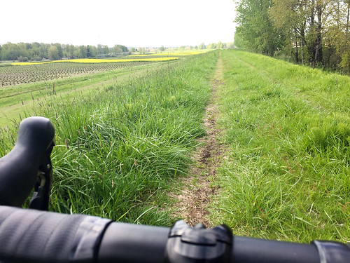
Once over the river, stay on the path as it loops back toward the river and then heads north under I-84. This new path connects directly to NE Harlow Road on the north side of I-84. From Harlow you can choose to stay on the pavement and connect to NE Graham, or drop right into a dirt trail. This is where things get fun.

Advertisement
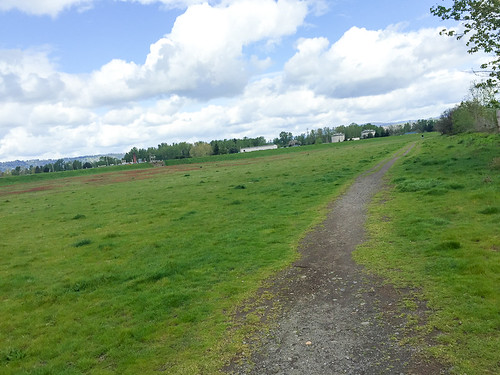
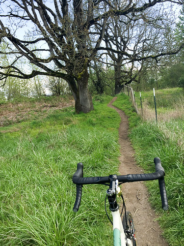
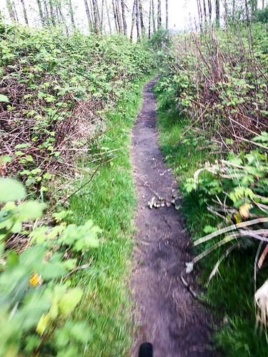
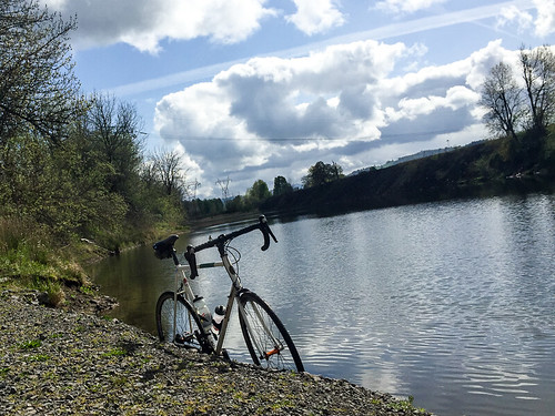
Turns out there’s a 1.5 mile section of the 40-Mile Loop in this area that I’d never even heard of before. It goes between Graham Rd and Sundial Rd. The 40-Mile Loop paved path is fine and good, but there are also a bunch of dirt trails below the path. These trails (on land owned partially owned by the Port of Portland and set aside as wildlife area) access the Sandy River and a bunch of other undeveloped land stretching out to the Sandy River Delta where it empties out into the Columbia River.
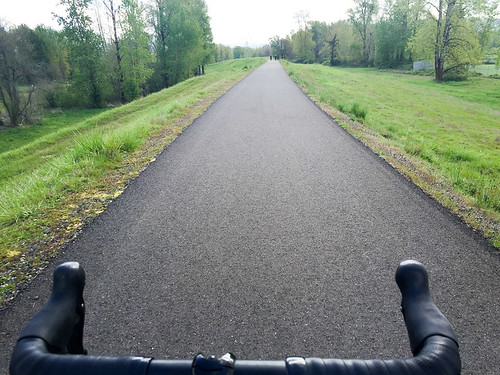
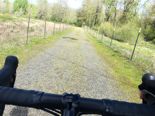

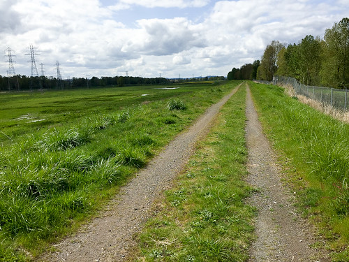
After you’ve had some fun in the dirt, you’ll head west and eventually need to get on the paved path. Take the path all the way to Sundial Road. At that point, you could take Sundial back south to Marine Drive. If you did that, you’d be west of airport and would have avoided all annoying traffic and freeway on-ramps around Troutdale. But, if you are up for a bit more adventure, when you come off the paved path at Sundial, continue west. The road will veer into some industrial operations, but you’ll notice a dirt road continues at the edge of the treeline. Stay on this road (it’s very overgrown with grass) for about a mile and it will take you to NE 223rd. At this point, you’ll head south and back onto Marine Drive just east of Blue Lake Regional Park.
I was very excited to make this connection and will use it every time from now on. If it’s new to you, I hope you enjoy it!
— Check out my route on RideWithGPS for more details.


Thanks for reading.
BikePortland has served this community with independent community journalism since 2005. We rely on subscriptions from readers like you to survive. Your financial support is vital in keeping this valuable resource alive and well.
Please subscribe today to strengthen and expand our work.
Funny, yesterday I did my birthday ride (44 miles on a 44 year old bike for my 44th Bday – kinda wish I had a 4 speed hub rather than a 3 for this year), and considered heading out to Sandy point to follow this or a similar path back to town. If I remember there’s quite a few little offshoot trails out there if you’re not tied to your GPS, which for this 44 ride I tried to be, which is uncommon.
But instead choose to go as far east as Blue Lake. Because I like riding through Bridgetown and around the Slough and PIR trails, and don’t get out there as often as I’d like to, and heading as far out as you did the 44 miles would have me returning towards home down 33rd. Which is a less interesting route home than coming from North Portland.
I still always find it funny that despite the fact there isn’t much within walking distance to the Columbia River Trails, I always encounter many more walkers than bicycle riders on that series of trails. Especially considering I think it’s one of the most interesting and fairly easy (depending on the wind) rides in town.
Happy Birthday!!
Thanks
Could you show a map of the whole thing? The bridge detail is not clear to me. Thanks!!
Very nice! Love discoveries like this.
As BP readers complain (often justifiably) about lack of improvement in the cycling network, pieces continue to be added to the puzzle and bad connections are made better. Even as ODOT is vilified for many things, it does projects that make cycling better.
I can already hear complaints that this serves the lesser “recreational rider” and more important transportation riders are ignored. Well I a grouper and not a splitter and what is good for one is good for all.
Jonathan-Thanks for highlighting this route! We must have missed you on the Policy Makers ride a couple of years ago when we traveled this section of the 40 Mile Loop. http://www.40mileloop.org
How many salmon died because your rode a bicycle on a singletrack trail? Did you slam into any hikers, off-leash dogs or small children while riding wildly out of control? Could you go back next week in a helicopter and get some aerial photos of the devastating silt runoff caused by the erosion?
No, you don’t have to answer any of that because they’re all silly arguments.
This looks like a really fun ride!
Zimmerman
It sounds like you are discussing the rogue trails on private property at the cemetery on Mt. Scott (which employed no soil conservation measures in either design or construction on the steep private property terrain) not the flat established trails and paved MUPs described in the article.
Jonathan: On the dirt road part, did you have to go around No Trespassing signs? I’ve done that segment many times but always had to be a scofflaw about it. Is it actually open now?
Didn’t understand the reference to riding on the Marine Dr. shoulder in the caption under the last photo. I believe the paved path westbound begins on the south side of Marine Dr. at the Sundial traffic light.
I think that dirt trail is smoother than the Marine Dr one at that point.
You may be right, there are a lot of “root bumps”!
If you have chosen to travel west into and through Troutdale, access is off 257th/Graham north over the RR overpass. A new path begins at the NW corner of the Outlet Mall just before the eastbound I-84 onramp.
Thanks for sharing this, Jonathan. I’ve wished there was an alternative connection from Marine Dr to Hwy 30 ever since I first went out there. I checked it out this morning and I think this will be my preferred route too.
The dirt track between 223rd and Sundial doesn’t look very promising from the western side, but coming from the east it’s very pleasant. Didn’t see any no trespassing signs at the eastern entrance.
They (ODOT?) could certainly do more to provide signage for the bike/ped bridge along I-84, but I’m guessing that’s in the plans for later (it all looked really new).
Made this the east end of a two day stealth camping micro tour. One pic that would have changed my mind (ended up tenting at Chinook landing beach), was of all the NO OVERNIGHT CAMPING signs at EVERY trailhead to the Sandy river. Not that a sign alone has ever stopped me, but also….soooo many power line crossings overhead made feeling comfortable difficult. Just my opinions. The singletrack portion that popped me out right at Chinooks driveway was spectacular!!! Thanks for the secret trail info!
The road will veer into some industrial operations, but you’ll notice a dirt road continues at the edge of the treeline. Stay on this road (it’s very overgrown with grass) for about a mile and it will take you to NE 223rd. At this point, you’ll head south and back onto Marine Drive just east of Blue Lake Regional Park.
Who knew? Rode it today. Far superior to the old route. Thanks Jonathan.
Buddy and I got this done twice in 2 days! Watch for the ruins of old, near the beginning of the grass path, because there’s some pokey rebar. Grass is tall now, but the paths both do go through still…
Ratio Ray
@pdxcab
Completing a portion of future 40-mile loop we went searching for 10 years ago, finally found.
@EmettS
(link: https://strava.app.link/kNJacwd1FY) strava.app.link/kNJacwd1FY
Hey, just rode this today. I left the house early and rode more than a few miles from home for the first time in a month+. I hadn’t been out towards Troutdale in YEARS, and wow, what a great surprise this was. I missed the turn headed east into Troutdale by the truckstops. It would be great if it was actually signed somewhere to let you know that you need to head straight towards the outlet mall at the end of the truck stop gauntlet.
I rode into Troutdale and past Glen Otto park, over the CLOSED to auto traffic (!!!) bridge. That was a nice treat. I then headed downstream, past the closed beaches, which were so peaceful, and over the 84 bridge and rode all the way to Chinook landing. I saw a lot of dog walkers at the Harlow rd end, no doubt because the Sandy River Delta Dog Park is closed. I also noticed a lot of survey stakes in the ground along the Harlow section, and at the end towards 223. Maybe that paving project is finally happening? At any rate, I’ll be sure to always take this route to and from Troutdale. Thanks for sharing the GPS and this write up.