
(Photo: J. Maus/BikePortland)
UPDATE, 6/27: The start date of the closure has been pushed back to July 9th so the path will be open for the busy 4th of July and Waterfront Blues Festival Weekend.
“It’s going to be uncomfortable. We know that. No option will be as good as the Springwater. We know that. But it’s temporary, and at least we have options now.”
That’s how Bureau of Environmental Services (BES) Program Coordinator Ronda Fast described the upcoming four-month closure of the Springwater Corridor path that will impact many Portlanders this summer. Fast was at the BAC meeting to explain how BES will handle the diversion of thousands of daily bicycling trips that currently use the Springwater to get between Sellwood and downtown Portland.
The meeting came just a few days after we reported that BES rejected a detour proposal by the Sellwood Moreland Improvement League (SMILE, the neighborhood association). The disagreement stems from how best to handle thousands of bike trips per day that will be forced off the Springwater and onto other routes due to a major project to salmon habitat at Oaks Bottom Wildlife Refuge. BES wants to direct people either to the west side of the Willamette River (on a circuitous, narrow and poorly maintained greenway path), or onto the SE 19th Avenue Neighborhood Greenway — which is 10 blocks east of the Springwater. The neighborhood proposed what they feel is a more direct and safer route on 14th/15th and SE Milwaukie — where they asked for temporary bike lanes in space currently used for on-street auto parking.
BES says the neighborhood’s proposal is not feasible and is “out of scope” for the project.

Last night Fast revealed the draft maps of the routes they’ll recommend come July (see below). For riders who opt to stay on the eastside, they’ll push east-west bike traffic onto Spokane and Umatilla to 19th. From 19th, the route will jog onto 20th in the northern section between Reedway and Insley. Insley will then take riders to a couplet on Milwaukie (northbound in a currently unstriped, door-zone bike lane) and 17th (southbound). The official route will then use 17th to cross McLoughlin to reach points north.
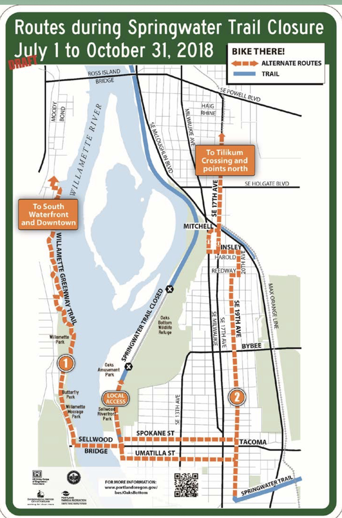
Fast said BES and their project partners at the Parks Bureau opted to not recommend that bike riders use the paved multi-use path inside Oaks Bottom Park that connects Milwaukie to the Springwater (at Mitchell). “That’s not a route we want to showcase as a primary option,” she said. “It’s not one we’re advocating for commuters to use because there are a lot of issues that would be exacerbated, especially with an increase in bike traffic.” Fast didn’t go into any more detail (I’ve reached out to follow-up but haven’t heard back yet); but it’s likely that Parks is concerned with how bicycle users will behave on the path. From the parking lot down to the floodplain there’s a relatively steep incline. And given what I know about how Parks views bicycle riders, I’m sure they assume people will ride too fast and will have collisions with other path users.
Advertisement

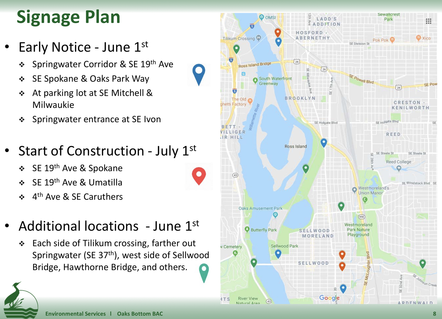
BES plans to do a comprehensive signage plan and Fast said their aim will be to, “Make sure people know in advance so they can make decisions themselves.”
At one point, Fast maintained that they don’t call their plan a “detour.” Rather, it’s a set of recommendations and bicycle users can make up their routes based on their best judgment.
Overall, the presentation didn’t go over well with BAC members.
David Stein held up a photograph of a young girl and said, “What’s being proposed doesn’t fit with our target design user. This isn’t a ‘nice-to-have’… The Springwater is not only a commuter route, but a recreational route.” Stein said he worries about how people will find their way once the path is closed. Fast replied by saying, “I’m prepared to do as much signage as needed… Even street teams on key dates.” “We know how big this is,” she continued. “So we’re pulling out tools in our toolkit that we haven’t pulled out before.”
(Note: The path will be open for use all the way up to the closure site — you just won’t be able to go through.)
BAC member Reza Farhoudi asked Fast why they rejected the Sellwood neighborhood’s proposal. Parks planner Emily Roth spoke up to say they wanted to stay on signed routes that have bicycle treatments and that have the support of PBOT. “The roads proposed by SMILE are not improved roadways,” Roth said. “If people want to use that they are welcome to… This is a project to preserve fish and wildlife… They [SMILE] have a good idea, but those roads can’t be improved as part of this project. It’s just not feasible.”
“I’m just concerned when the needs of parking goes above the needs of bicycle riders,” Farhoudi added. “Parking was not the main factor in our response,” Fast replied. “The main factor was that we have a main route that will be safe and signed.”
Roth then said if people wanted to get off their bikes and walk on Oaks Bottom hiking trails “as a pedestrian” they are welcome to.
The final word came from BAC Chair Rithy Khut who said, “I’m not happy with this process. This is the second time you’ve come to us with this detour plan and just stated, ‘This is happening.'” Khut added that since the city had years to plan for this project, agencies should have “pooled their resources” to install safe bike lanes prior to the closure. Khut also lamented that the committee didn’t have more time to discuss the situation due to other items on the agenda.
“It’s really frustrating,” he said.
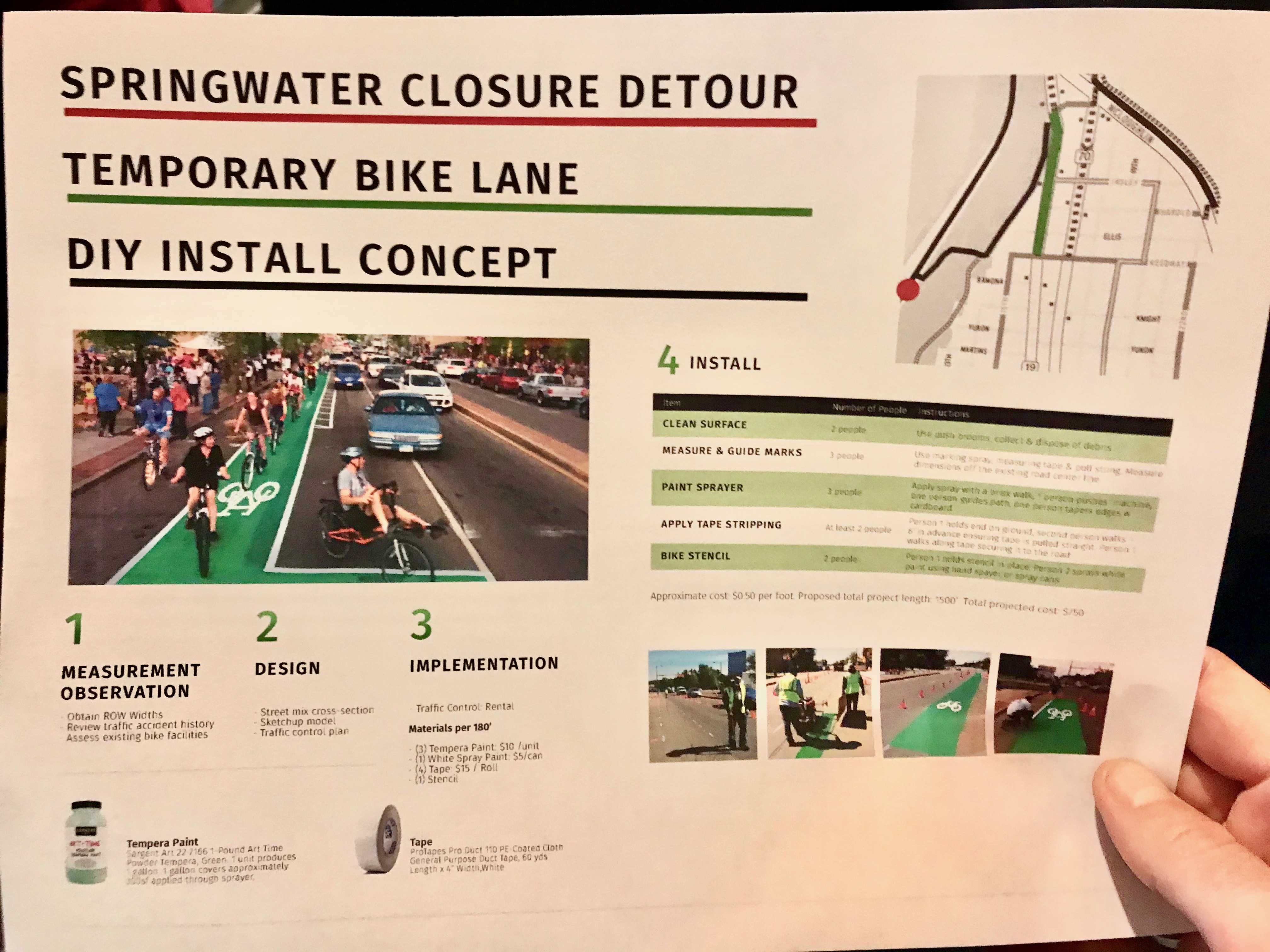
One member of the audience at last night’s meeting passed around a flyer (below) of a “Temporary bike lane DIY install concept” and a map showing a green bike lane on SE Milwaukie between Reedway and Mitchell:
The closure is set to begin July 1st and will last through October.
UPDATE, 4:20 pm: Portland Parks Community Relations Manager Jennifer Yocom emailed to clarify some points, and explain their rationale for not recommending the paved path through the Oaks Bottom Wildlife Refuge park (emphases mine):
“We are communicating preferred options, not detours. We have crafted preferred options that cause as little disruption to the entire bike system and parks system as possible—as you know, this disruption is temporary.
The bicycle options shown on the map are locations where the city has built infrastructure and spent resources to provide safe and enjoyable bicycle routes. The Sellwood Bridge has bicycle lanes and the regional trail on the west side was recently completed all the way through Willamette Park. This makes a trail connection all the way to downtown. PBOT is completing the SE 19th Avenue bike route as shown on the Bike Plan.
Oaks Bottom Wildlife Refuge is managed for many uses – education, wildlife viewing, and walking/hiking for humans, and important habitat for wildlife, including red-legged frogs. It is an important bird areas in the city. Users are required to stay on designated trails in the refuge. The paved trail is often used by school groups (even during the summer) and families to enjoy the refuge. Portland Parks & Recreation wants to ensure all our users have an safe and enjoyable experience in the refuge. We accomplish this by reducing conflicts that may occur. For instance, we have school groups and camps get permits in such a way that there are not too many people in one area at a time. Dogs must be on a leash to protect users and wildlife. Wildlife are often most active early in the morning and later in the evening. The path through Oaks Bottom Wildlife Refuge will remain open and is not shown as a preferred option to reduce conflicts with other users experiences and wildlife protection.”
— Jonathan Maus: (503) 706-8804, @jonathan_maus on Twitter and jonathan@bikeportland.org
Never miss a story. Sign-up for the daily BP Headlines email.
BikePortland needs your support.


Thanks for reading.
BikePortland has served this community with independent community journalism since 2005. We rely on subscriptions from readers like you to survive. Your financial support is vital in keeping this valuable resource alive and well.
Please subscribe today to strengthen and expand our work.
I am super curious to see what happens to that trail – and its residents – when left alone for a few months.
This is an example of why the focus on “safety” only is problematic. Yeah (if we forget about the giant bumps) people would probably be safer on the Willamette Greenway than on SMILE’s suggested route. And maybe there’s some way that PBOT can say that their suggested Spokane/Umatilla/SE 19th/20th/Insley/Reedway/17th/Mitchell route is very marginally safer than SMILE’s suggested route (in some fantasy world where people don’t get off-route onto dangerous facilities on a regular basis). But convenience is a thing too, and routefinding ease is a thing, and both really, really matter as to what people actually do.
If PBOT costed out SMILE’s alternative, and it cost $250,000 more, and they said they think it’s wiser to spend that on East Portland or some other high priority, I’d be convinced. But these high-handed claims that this circuitous, inconvenient route is safer and more “feasible” and a fait accompli with no substantiation of those claims don’t inspire confidence.
The westside route is definitely not “a trail connection all the way to downtown.”. Besides the street segment and private property nonsense at the south end, there is also the gap at the north where you’re in a door zone lane on bond for several blocks south of the tram.
Macadam could spare a lane or two. It’s not like drivers don’t have plenty of roads available.
So they’re telling SMILE that their plan doesn’t work because there’s no ped/bike infrastructure on that route, and the city’s decision is final? Not a good way to make friends and influence people. By the way, the Autism Society of Oregon’s annual fundraising walk event is at Oaks Park on Sunday 4/22. This brings a lot of traffic into the Oaks Park area, and many participants come on bikes via the Springwater and then leave on bikes at the end of the day. This might be an opportunity to advise a large number of people about the SWT closure and the city’s decision to ignore SMILE entirely. There’s usually a large number of folks who use the SWT to see the Blues Festival fireworks show on 7/4. The closing of the trail on 7/1 means that people will have to use the city’s detour to get to the east bank area at OMSI and back, or use Max to get there. Folks will need a lot of info to plan for that.
Remember when we used to ride bikes on the trails at Oak’s Bottom? Our after work ride went to Riverview and back across the bridge back to Oak’s Bottom. We had some sweet jumps at down there at one time, though admittedly not as well developed as the Grotto.
Closed paved bike paths would not have been an issue. Thinking about that is a bit depressing.
The intersection of 17th and McLoughlin is going to be an absolute nightmare both times of the day, but particularly after work. A super busy intersection crossing a super busy road where the bike lane abruptly ends crossing south, and merges you right into traffic where there is commonly conflict with cars as they try to avoid being stuck behind you till you get to Insley. Then you get to try and attempt a left turn onto Insley where the cars who didn’t already pass you also don’t want to wait for you and zoom around on the left in the opposite lane.
When we needed to fix the Sellwood Bridge, we spent a lot of cash & time to *move* the *entire bridge* to avoid long-term closure to car traffic.
But when a critical piece of bike infrastructure is impacted, we close it for months, deny reasonable requests for accommodation, and shrug.
This really highlights a huge missed opportunity when Trimet’s Orange line went in: a MUP from 17th to the Springwater adjacent to the tracks. They definitely had space for it, but it just isn’t a priority for some reason. Every new MAX line should have a high-quality, parallel bike route. This should have happened with the Blue, Red, and Orange lines.
My understanding is ODOT blocked this option to preserve ROW space for someday future road expansion. Thanks ODOT.
UPDATE, 4:20 pm: Portland Parks Community Relations Manager Jennifer Yocom emailed to clarify some points, and explain their rationale for not recommending the paved path through the Oaks Bottom Wildlife Refuge park (emphases mine):
As suspected, Parks does not feel that people riding bicycles are compatible with other path users. That’s a very unfortunate world view in my opinion. By not including that path through the park in their recommendations, Parks is clearly choosing the safety of one user group over the safety of another with zero factual or statistical basis to do so.
This same flawed and biased opinion about cycling is what led Parks to completely bungle the Forest Park singletrack issue when it was first debated back in 2010. The idea that bicycle users are inherently dangerous pervades the Parks Bureau and it informs how they manage bicycle use.
The fact remains that because Parks assumes bicycle users will behave recklessly on that path, more people will end up riding on SE 17th/Milwaukie/McLoughlin — an area that puts bicycle riders in danger due to the presence of reckless auto users.
It’s disappointing to me that Parks/BES couldn’t work together with PBOT to make the park path part of the recommended detour route…err…. i mean recommend “preferred options” route.
If they BES was concerned about the safety of all users they should have worked with PBOT years ago to make sure that the planned 19th ave Greenway was a solid alternative. Instead, their “option” involves traveling on a busy fast street in unprotected doorzone bike lanes. When SMILE asked for better protection, members were told very clearly that removing parking was not feasible.
So it’s not recommended, but is it prohibited?
No. Not prohibited.
Could the issue be that the decision-makers at BES and Parks are generally some of those dangerously behaving motorists and at other times are pedestrians but are never the cyclists?
No way would I ride that detour if I was headed for downtown, I would opt for SE 13th and neighborhood streets east of Milwaukie as far as I could take them, and then MIlwaukie to points north of Powell.
…west of Milwaukie…
I rode that detour for a long time a few years ago when the Springwater was closed due to the slide. I kept riding it for a while after the path opened because it was quicker. My conclusion was that riding on Milwaukie was just not worth getting hassled by impatient drivers so I switched to a route similar to Park’s proposal.
What really gets me is the blatant statement that parking is more important than the lives of cyclists. There are some serious screws loose in the heads of anyone who thinks that way.
That’s been the party line ever since parking was last removed for a bike lane – SE 26th south of SE Clinton, the first bike lane the city ever installed in modern times.
Not true, parking was removed on one side of SE 52nd between Division and Woodstock to make way for the bike lanes there (sewer grate hole-ridden on the one side and door-zone on the other side though they are).
and how well did that go over? ’cause the n’hood response is what guides PBOT’s future actions, positive or negative…
Actually it worked out fine. There were a few complaints and a yard sign or two, but those lanes on 52nd get a lot of use now.
The main problem was the missed opportunity to remove parking on *both* sides and create protected bike lanes comfortable for folks of all ages and abilities 🙂
So, are any changes planned for the signal timing on 17th and 99E? I ask this because
If you are a pedestrian on the south side of the intersection and the light rail comes through, you WILL have to wait through MULTIPLE signal cycles in order to do nothing more than cross the road.
Try it sometime, it’s what I would call fairly egregious. The walk-through gates on the tracks do no good if you never have the signal to get across the ~150ft of car travel lanes.
This is now fixed. If you press the button you will get a walk signal, even when the train is coming.
LOL, once they realize that they will F it up, just like at N B’way btwn wheeler and ross.
Jonathan, at the meeting did they reveal whether the Springwater section will be closed 24 hours, or only during normal construction times (8:00 AM to 5:00 PM)? If the latter, that would enable many commuters to get through.
24 hours. It will have a huge hole in it so they can replace a culvert.
Oh. Well then, really outside the box, how about a commute hours bike shuttle ferry barge on the river from Sellwood Riverside Park to the Sand & Gravel ramp?
Taking the Sellwood and the west side greenway will be faster than waiting for some kind of expensive ferry solution.
For the many fit/fast bikers going downtown, sure. But for other, slower bikers commuting to/from destinations on the Eastside, a shuttle ferry could be just the thing to keep them on the safe path. Speed isn’t everything for all commuters. And maybe it would inspire more river transportation.
Haven’t been on Spring Water in a little bit, but it seems like now would be the time to put up signs about the future closure since it is such a heavily used route. Put one up at the entry points as well as exactly where the closure will be. The worst user experience is just having to adapt plans rather than knowing about a closure.
So…..they are so concerned about safety – bike/pedestrian interactions that they are pushing the west side Willamette Greenway Trail as an alternative? That is simply laughable. That trail is a bumpy, narrow, blind corner mess. The fact that BES suggests that alternative says it all.
If this was a road closure……
This would be comparable to them closing I-5 through the Terwilleger curves and not doing anything to improve conditions on the surface street detour.
I don’t think I understand the couplet thing. Going north, why would I climb that hill just to ride a short distance on Milwaukie, go back down the hill, and continue on 17th?
Oh for ducks sake, ride the paths around it. Be cool, and chill out next to others. The path around the wetland is mellow. A road bike would be fine. The reach of parks is laughable, and getting smashed on the detour isnt worth it.
The map isn’t confidence-inspiring. The proposed westside route shows two parks (Butterfly and Willamette Moorage) that no longer exist, and the trail through Willamette Park is on the wrong side of the park.
The last time BES did a project near me, it created a dead end for cars on SW Macadam that was forcing several hundred drivers per night, for several nights per week, for several weeks, to do illegal, dangerous u-turns to escape. It also led to several dozen drivers per night getting confused and driving northbound on Macadam in the southbound lane, unable to escape because of the median. I pointed all that out the first night of the detour, and it still took weeks to fix.
Granted, that detour was managed by PBOT, not BES. But this one looks to be managed or at least strongly influenced by Parks, who I trust less than PBOT for being concerned for detourees.
It’s for the fish, people. Stop complaining 🙂
Parks is concerned about cyclists going to fast down the hill from on the ‘cut through’ path from Milwaukie to the Springwater, but are completely ok with routing cyclists down the SUPER steep Mitchell where it intersects with 17th where there are fast moving car drivers (then cyclists are supposed to make a left onto 17th through car traffic that is always stopped at the light at all times of the day). Big guess as to which route is safer and more accessible to the 8-80 groupset — I can say that I’d never take the Mitchell route with either my mother or my 9 year old nephew and expect them to be able to safely stop at the bottom of Mitchel at 17th.
Similarly, have they thought through the safe capacity of the west side path? I fear the west side path will become a giant mess as way too many people try to use it as a detour around the closure. If safety were truly their main concern, they would have at least planned to improve the conditions on the west side before recommending it as a “preferred” route.
It seems like some of the problem is how bureaus here focus on themselves. So Parks thinks there’s some safety issue with people on bikes in their park, and sends them out onto streets that are much more dangerous, but that’s irrelevant to Parks, because that’s PBOT’s concern. It’s similar to what ODOT seems to do with PBOT regularly.
I rode the westside path from downtown to Sellwood bridge for the first time in a long time yesterday. The tree root bumps are very bad is some places. The path is also narrow and curvy in many places. My general thought was that it was workable and okay for now. I worry about whether it can accommodate the added bike, runner, and walking traffic that will likely use it during the detour. The Springwater gets very busy during the summer and I’m not sure how many of those people will use the westside instead. I fear that path will become quite dangerous.
Is there anyway to fix the tree root bumps ahead of the detour? I imagine that part of the path is owned by the adjacent buildings, but similar to sidewalks, the owners have the responsibility to maintain the path. A couple letters from Parks and/or PBOT stating they must fix those bumps usually gets a quick response. Me and my neighbors got similar letters a few years ago saying we had to fix the bumps in our sidewalks.
It’s still not clear why the path needs to be closed for four months. TriMet built a temporary path over the bridge access when they constructed the Tilikum crossing. Why doesn’t BES/Parks provide a similar temporary facility rather than these awful detours all summer?
BES / Parks can be a tough battle. They have refused to install a temporary bridge over Tryon Creek at SW Boones Ferry Road in SW Portland for the 2019 / 2020 replacement of a culvert for Tryon Creek. Complete opposite decision versus Washington County’s Fanno Creek bridge replacements.
I take the paved path through Oaks Refuge every weekend from the Springwater to Milwaukie. It is much preferred to Milwaukie and 17th (to reach 24hr fitness). Being alert and watching my speed allows for a fun trip.
What paved path ? The paved Springwater ?
Having lived on Milwaukie for nearly 10 yrs, right where this “detour” will pass, and now living on the SE 19th portion, I’m in agreement w/ many of the frustrations voiced here. I’m an experienced, confident cyclist and it’s gotten to the point where even I won’t ride that section of Milwaukie b/w Insley and Mitchell–no room, and increased traffic volume and speeds over the last few years are a literal accident waiting to happen. To say nothing of the numerous actual collisions I witnessed, or witnessed the aftermath of, while living there.
I’m all for more people riding the 19th Ave Greenway, but agree with all the points made about efficacy and safety. Honestly, the temporary bike lane tactical install is pretty appealing. Happy to help make that a reality 😉
Platinum!
Considering the limited budget of Parks, and all the other significant improvements that could be made system wide, I am very happy to see they stood their ground against SMILE and any other ridiculous alternatives. The Springwater is a world class MUP, to think it’s convenience and quality should be replaced for a temporary closure is naive and disconcerting as to the resourcefulness of folks around here. If your intent is actually riding the Springwater from Downtown to Gresham/Boring and vice-versa, the 19th ave detour using the hill from the Springwater to Milwaukie is a perfectly acceptable option. Use your brain and brakes in equal measure and you won’t hit anyone, they won’t hit you and gasp, you may have some fun.
It isn’t family-friendly crossing Highway 99.
So don’t. Using the path from Milwaukie to the Springwater avoids 99.
Came here to post what I’d seen this weekend, but I’ve come to a different thought: Springwater in the summer is the perfect place and time not just for its nominal users but restoring the environment passes through. This work needs to be done with minimal habitat disruption, i.e. during the dry season and as quickly as possible.
I will always come from the bicycling side, but in the bigger picture I feel as though we owe this much back to the wetlands we have taken away from.