(Photo: J. Maus/BikePortland)
The updated Washington Park Master Plan that passed unanimously by Portland City Council on March 15th is the plan we need for our central city.
Its transportation elements include a vision to: keep cars on the periphery, reduce access for drivers, aggressively encourage transit use, create plaza and green spaces, and build protected paths for cycling and walking.
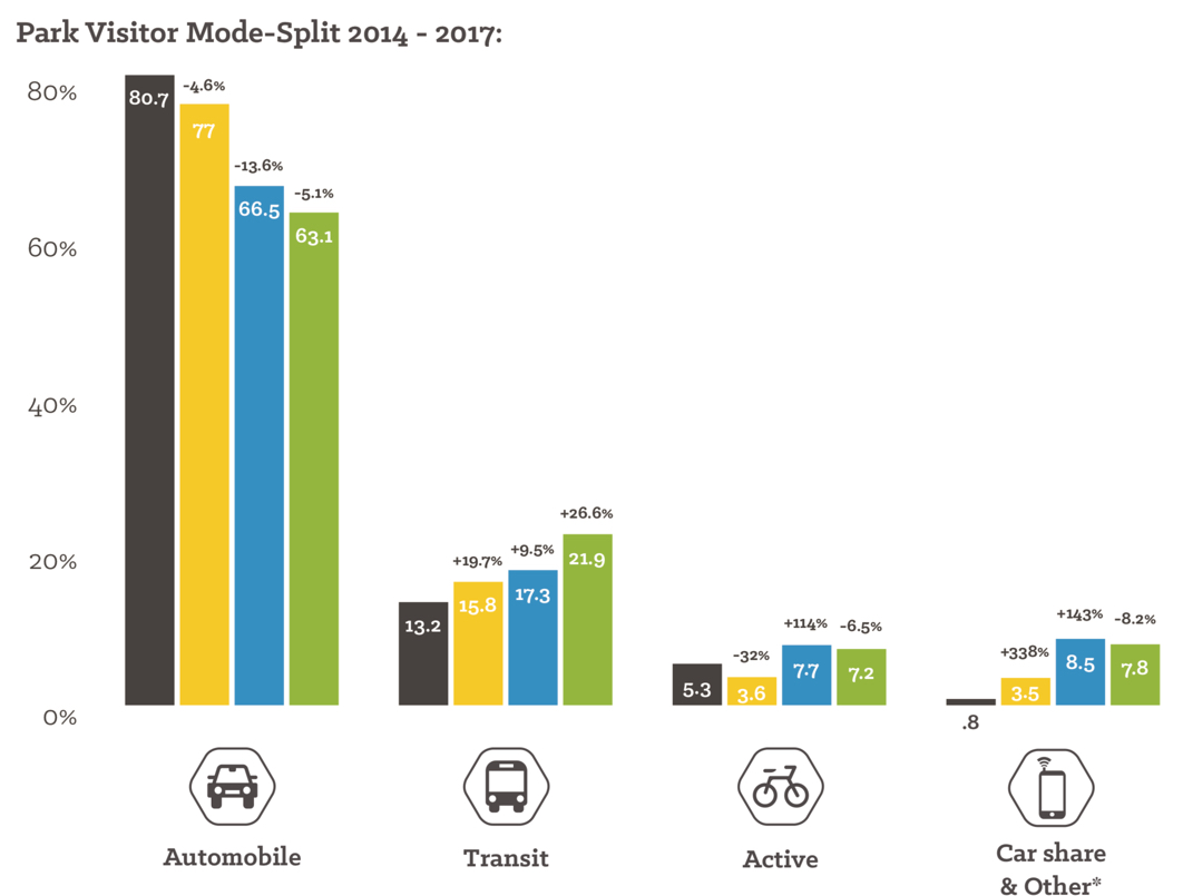
Washington Park is the “jewel in the crown” of our parks system (to quote Parks Commissioner Amanda Fritz) and it had been operating under a master plan that was passed in 1981. Because of smart management by Explore Washington Park (a city-funded Transportation Management Association, or TMA), auto use has declined considerably in the park in the past five years. In 2014, 80 percent of park visitors arrived by car. Last year that number was down to just 63 percent.
The updated master plan will hasten that curve.
Here are some other noteworthy elements of the plan…
“Reduce the dominance of cars”

(Drawing: City of Portland)
Park planners see the transportation issue in two parts: How people arrive at the park, and how they move around once inside it. On both fronts, the plan places a strong emphasis on leaving cars at home. Why? In addition to all the standard reasons, their 2017 visitor survey showed people who use transit and bikes to get to the park are around 17 percent more satisfied with their experience than those who drive.
To help encourage even more transit and bike use, here are just some changes the plan envisions:
- strengthening connections from the Goose Hollow and Kings Hill MAX light rail stops and changing their names to “Washington Park North” and “Washington Park Central”,
- improving the entrance on Burnside at 24th to draw foot and bike traffic from the popular NW 23rd commercial and residential area,
- closing SW Tichener and Kingston in the northern end of the park to private vehicles and leaving it open only for biking, walking, shuttles and maintenance vehicles,
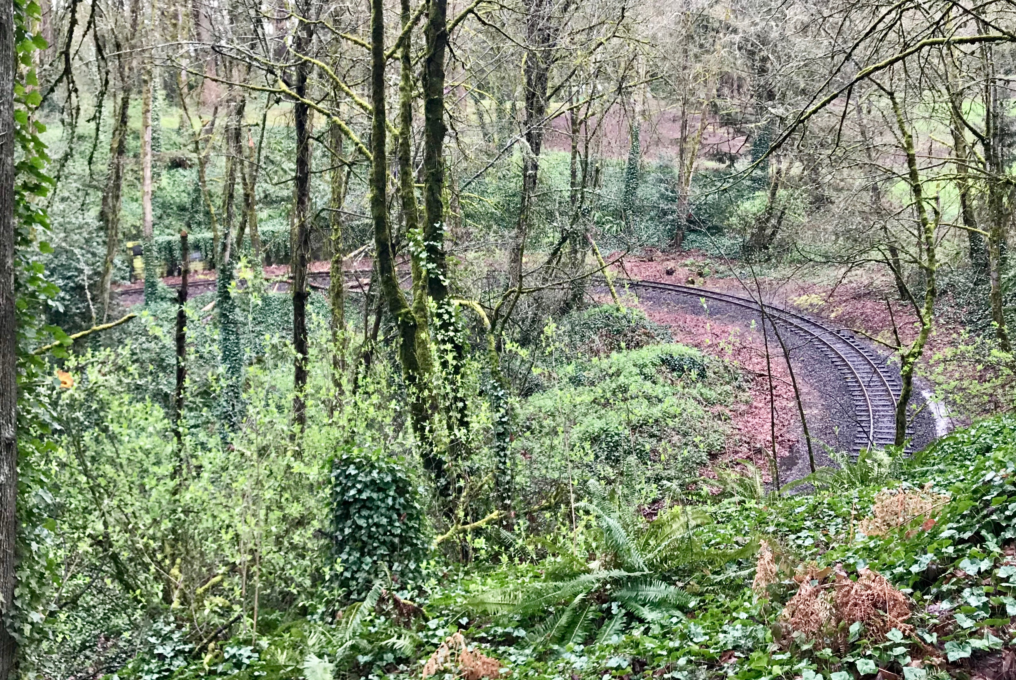
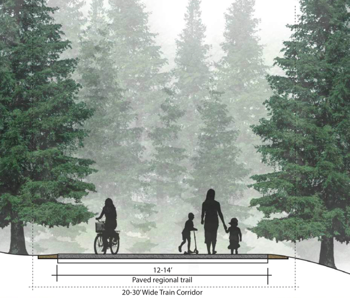
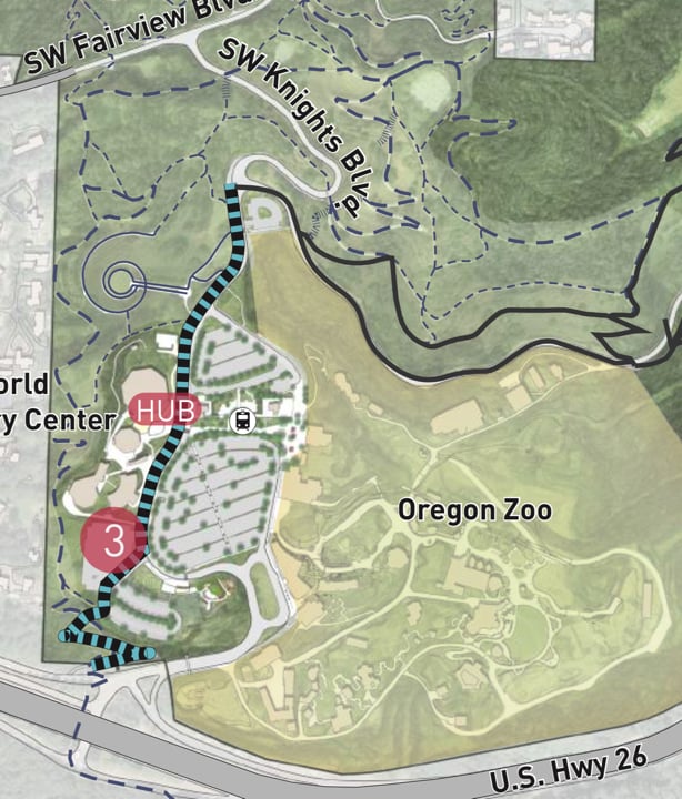
- a new regional trail along the existing “Zoo Train” right-of-way (which is operated by Metro via a lease from City of Portland),
- moving the large surface parking lot at the Oregon Zoo into a new parking structure (to be built someday in the Sylvan area) and replacing it with a “central green space.”
The plan’s priorities were broken down into three phases. Phase 1 calls for a new transportation management plan (TMP) that will delve deeper into parking, circulation and access issues. The plan will be developed by Explore Washington Park — an organization with a very favorable opinion of transit, biking and walking.
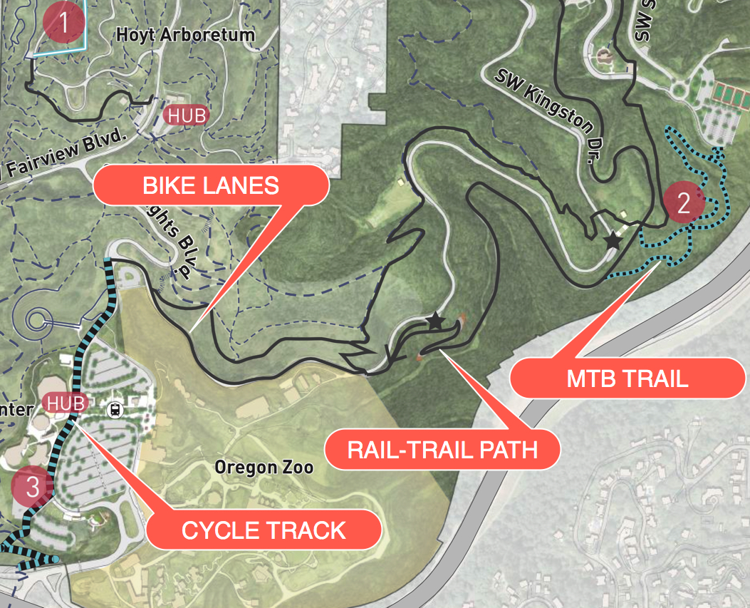
Off-road bicycling — paved and unpaved — and next to the Zoo Train?
People that like to ride dirt trails on bikes fared relatively well in the plan — thanks in large part to strong advocacy from Northwest Trail Alliance (NWTA).
The plan initially called for a new off-road cycling trail between SW Kingston Drive and the southeastern corner of the park to be completed in Phase 3 — a $32 million list of projects to be completed 15 or more years from now. NWTA advocate Andrew Jansky testified during the March 15th hearing that he felt that was too long to wait. Before voting “yes” on the plan, Commissioner Dan Saltzman said he was “sympathetic” to the case laid out by Jansky. “Any chance we can move that into the Phase 1?” he asked Portland Parks Director Mike Abbaté. “Yes,” Abbaté replied. (Keep in mind this is a master plan, a visionary/guiding document without funding. It’s not an implementation plan and everything is subject to change.)
The other ray of hope for a new cycling experience in Washington Park is a potential paved path to be built within in the next five years either on or alongside the existing Zoo Train right-of-way. Metro (who owns the Zoo) operates the train; but it’s been out of commission since 2013 due to costly repairs. The new plan doesn’t take a position on whether the train should stay or go; but it makes clear a desire to create a path on its alignment:
“If the Zoo Train remains in operation, a narrower version of the regional trail should be explored. The tracks are never steeper than 4.5%, and a paved regional trail is an opportunity to reconnect the north and south ends of Washington Park.”
Given the emotional attachment to trains that many people have, this could become a big debate in the future. Parks sees the right-of-way as a way to achieve two major goals of the plan: to connect the north and south sections of the park and to separate walkers and bikers from auto users.
Sensing its demise, Commissioner Saltzman spoke up in defense of the train with more passion than I’ve heard from him on any issue. “I think the plan needs to prioritize the train,” he said. “I think the train is a fantastical [sic] element of the history of many of us who have grown up here.” Then Saltzman said he feels the plan is leaving out the voices of “certain populations… like families with young children and older adults, which I’d wager are the largest population segments in our city.”
Advertisement
“A lot of this plan is done with the ‘hale and hardy’ Portlander in mind,” Saltzman said, “And not the family raising four young kids in Hillsboro or the older adults who need accessibility.”
Commissioner Amanda Fritz then chimed in to say she’s personally experienced the “enthusiasm of rail supporters.” “They have a real ability to raise boatloads of money, so I don’t think we should discount that.” Commissioner Nick Fish concurred. Citing the $5 million raised for the Oregon Rail Heritage Center, he added, “I’ve never seen such indefatiguable fundraising from any group as train fans.”
Suffice it to say the train and a potential new path alongside it will be included in the scope of the upcoming Transportation Management Plan.
No more bikes on Rose Garden Way

The plan calls for turning SW Rose Garden Way into more of a plaza space open only for walking and shuttles. This is currently road preferred by bicycle riders. The new bike route would be to use the less interesting service road just below the Rose Garden.
Cycle-track on SW Knights Blvd
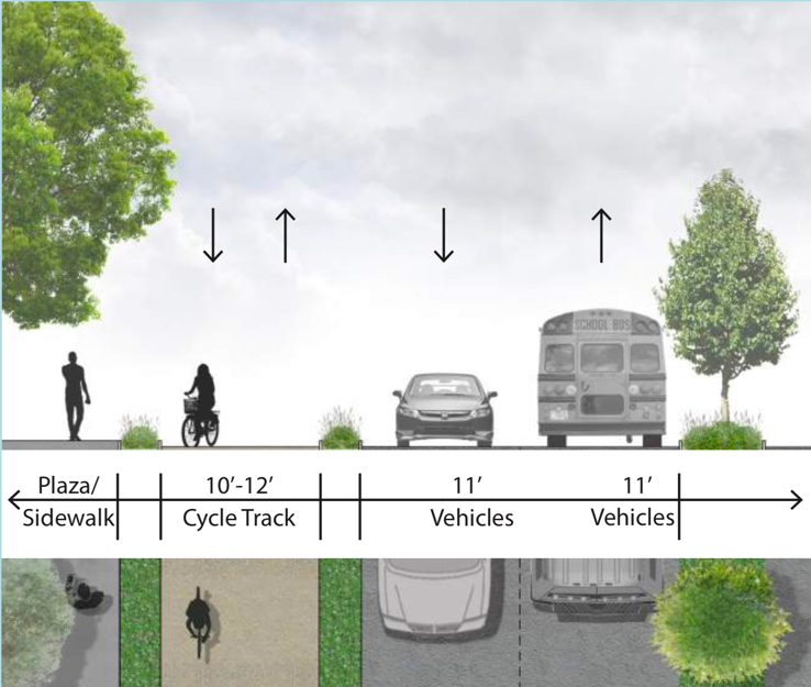
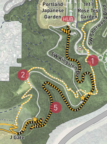
As part of the Phase 3 projects, the plan suggests building a 10-12-foot wide “cycle track” on SW Knights Blvd from the intersection with Kingston all the way to SW Canyon Court (near Highway 26). This would be part of major changes to the south entry of the park. A new cycle track and separated sidewalk would, “Close a gap in the regional trail network between Washington County and downtown Portland, and improves the experience for those hiking the 4T Trail.” As you can see in the map below, the blue and black line of the new cycle track could eventually connect to the bike lanes on Kingston.
Bike lanes on SW Kingston
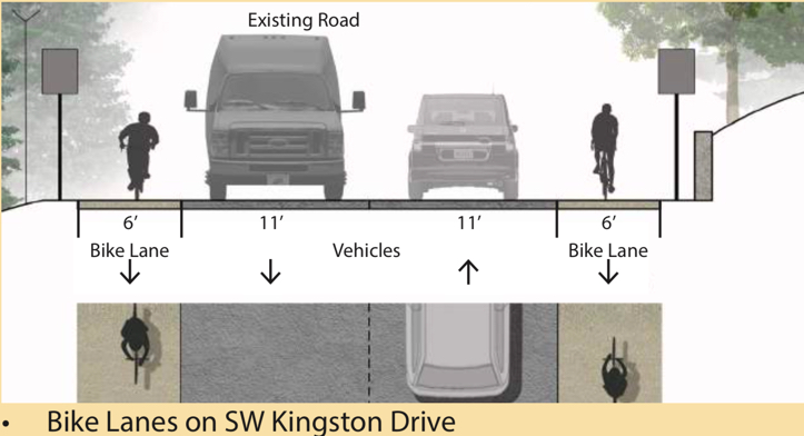
As part of their vision to improve bicycling in the park and reduce driving space (to slow people down), the plan envisions new bike-only lanes on SW Kingston from its intersection with SW Knights Blvd to the beginning of the future regional path along the Zoo Train alignment. “Visitors will be able to bicycle and walk from one end of the park separated from vehicle traffic,” the plan states.
Here’s how it looks when you put all the new paths together…
Carfree Kingston Drive
(Photo: J. Maus/BikePortland)
In response to strong community feedback to reduce the amount of cars in the park, the plan recommends closing SW Kingston to private auto use on Sundays or weekends. This is common in major parks in other cities and Portland Parks sees it as a perfect way to test how a carfree Kingston would impact users and other roads. The liken the idea to a mini Sunday Parkways that would, “let visitors walk, run or bicycle the 1.5-mile parkway, car-free.”
Kingston has had a car overuse problem for many decades and mixing drivers and bicycle users remains a problem. The 1981 Master Plan addressed the issue too: “Because of the amount of traffic the existing roadbed is unsafe for co-use by bicycles or pedestrians. The perceived danger of the curving narrow roadway and the sharp dropoffs discourages speeding although some misuse does occur by drivers using it as racing loop in connection with S.W Fairview Boulevard.”
Everything old is new again
What’s striking to me about this new plan is how many of the transportation issues — and the proposed solutions — are the same as we had 1981. In fact, the 1903 report on Washington Park written by the architectural firm of Frederick Olmsted and Sons included a recommendation to have separate pathways adjacent to all the roads, because it was, “neither agreeable nor appropriate to mix different modes of traffic.”
The 1981 plan raised concerns about too many cars in the park, a lack of places to park them, a high-stress cycling environment due to a lack of separation from car users, and so on.
And even making Kingston carfree isn’t really a bold idea when you consider Parks called for it 37 years ago. The old plan recommended to, “Close Kingston Boulevard on selected well-publicized days to allow for carfree special events such as ‘bike days’ and foot races.”
And while our 2018 plan calls for autonomous people movers, the 1981 plan had an equally futuristic idea: “An overhead tramway system,” that would, “carry surprisingly large numbers of people,” in podcars that would be, “silent, nonpolluting and require surprisingly little energy.”
Fast forward to today and that sentiment is as strong as ever. In his testimony to City Council on March 15th, Arlington Heights Neighborhood Association President Michael Wallace said, “We are particularly supportive of shifting vehicles out of the center of the park and improving access for people walking. We have long recognized that managing private vehicles is the key to improving the overall park experience.”
That was great to hear from an influential neighborhood association. And Wallace took it one step further, giving strong support to converting Kingston Drive into a multimodal path. “Removing the cars from SW Kingston Drive and converting it to a multimodal bicycle and pedestrian path should be in Phase 1 of the plan… The park is for people, not for vehicles.”
— Jonathan Maus: (503) 706-8804, @jonathan_maus on Twitter and jonathan@bikeportland.org
Never miss a story. Sign-up for the daily BP Headlines email.
BikePortland needs your support.


Thanks for reading.
BikePortland has served this community with independent community journalism since 2005. We rely on subscriptions from readers like you to survive. Your financial support is vital in keeping this valuable resource alive and well.
Please subscribe today to strengthen and expand our work.
Renaming the MAX stops does not strike me as a good or helpful change. A visitor to Portland might reasonably assume the “Washington Park Central” was centrally located in Washington Park, where it is actually a 30 minute walk up some pretty steep terrain to the Rose Garden.
On a slightly different note, the Kings Hill / SW Salmon station should just be closed. There’s no need for a station so close to the two stations either side of it.
i wouldn’t make much of that part of the plan. super minor. The cooler thing that I actually didn’t mention is how Explore Washington Park is really trying to promote parking at the TriMet Sunset Transit Center park and ride. It’s just a short ride into Washington Park and there’s a big parking lot there. It’d be cool if TriMet worked with them for some type of validated fare, but so far there’s no official partnership.
Yes, I doubt the renaming would get support from trimet anyway. It just struck me as an odd suggestion.
The challenge with that plan is that the parking structure at Sunset TC is often full. If they really want to effectively pull that off they would need to address that problem either by expanding parking at the TC (seems unlikely) or adding additional bus routes in the area so downtown commuters park elsewhere, such as one over Cornell Rd. Those of us in the Cedar Mill area would dearly love to see a route over Cornell for a whole variety of reasons, traffic, parking issues at the Audubon Society, low income access to the trails and Audubon Society, etc.
I wonder if this bike route will be nice enough for through-riders going from Beaverton to Portland to use in numbers. The major zig-zag is a big deterrent in my opinion. US-26 is a lot more direct – maybe a seperated path along the highway right-of-way would be a better option for this type of traffic to go. This trail will be a nice addition for travel within the park.
A bike path, a mountain bike one, might be part of the Portland SWIM plan. It would be on th south side of Highway 26 and go to the Jefferson Street exit. It is the Southwest In Motion Plan.
There is also opportunity for a braided mtb/ paved path along the rail corridor. I’m all for the South side trail also Rick!
Please urge Nick Falbo from PBOT about making a path on the south side of Highway 26 in the ODOT forest.
Riding on 26 is insane. You have to have a death wish to do that. The route up on Kingston goes fast and easy right now. Only problem is the super steep punch at the bottom and the cars that you do get tend to be real distracted idiots. Most through riders use Kingston. Very few ever use 26 for obvious safety reasons. Honestly if they pull through with the idea of closing Kingston to cars it’ll be borderline heaven to ride.
Riding Kingston is the highlight of my commute. Wish it was closed to cars completely. But I would be happy with sharrows there.
Eastbound on 26 during slow traffic periods (most of the day now) really isn’t bad. I wouldn’t do it with my kids, but it didn’t seem very risky when I’ve done it.
Thanks for calling several of us “insane”. I’m sure you’re a qualified mental health expert with the ability to diagnose us from wherever you sit. Riding downhill (EB) from the zoo to Jefferson during morning rush is objectively safer than either a) riding on any number of posted 45-mph roads in Beaverton/Washington county—even those with bike lanes, like Murray Blvd. or 185th Ave.—or b) certain alternatives for going over the hill, such as descending Broadway drive from Vista/Greenway. In the former case(s) cars travel much faster than the 35 or so that rush hour traffic on 26 attains, the bike lanes are much narrower than the highway shoulder, and there are many more opportunities for turning conflicts (on 26 between exits, there are zero turning conflicts). In the latter case, the steep grade and curves of roads like Broadway Drive both require much more braking, wearing out brakes and rims faster, and are significantly more dangerous even without cars, especially if it is wet out.
I would certainly agree that not everyone is up for a 35-mph descent down a mile of freeway shoulder, but try it once (or three times) before you judge others for using THE most direct route into town. So far, my “death wish” hasn’t come true—maybe because I don’t have one.
Agreed, I used to ride the uphill portion on Jefferson to the zoo ramp to pick up my daughter from school. The wide shoulder felt much safer than the Newbury & Vermont Bridges on Barbur, which I ride daily. Insane? Not so much. Bombing Scholls Fy w/ my 6th grader was perhaps. Though we are both still alive today.
Riding east on the right shoulder of Highway 26’s east-bound car lanes often has less debris than the bike lanes of SW Beaverton-Hillsdale Highway. ODOT allows it and has confirmed the bike usage from Sylvan to the Jefferson Street exit. I don’t care for riding on the potholed streets and dealing with the cut-thru car drivers in the SW Hills and riding the brakes downhill to Goose Hollow. I’ve only rode on the Highway 26 shoulder less than 20 times.
Out of Left Field: And how about a closure for winter sledding…or creation of an off road sled path…Winter ZooBomb sans wheels!
I’d love a carfree Kingston Drive. I’ve enjoyed riding and walking on that tree-lined street. Removing the weeds and Zoo train line for a bike path would be nice.
A ped/bike path connecting the Washington Park Max Station to downtown Portland should’ve been built during the construction of the west side tunnel. It would still make sense to do that today. If Max were closed for any reason, that path could serve as a dandy alternative. And it would be a more direct connection from Portland to Beaverton and points west. Better than that long hill from Kings Hill Station. That proposed West Burnside entrance has one problem. How do people coming off westbound buses cross the street to reach the entrance on the south side of Burnside? A tunnel under the street would make sense. Moving the Zoo parking lot to the Cedar Hills/Sunset Highway Station would make really good sense.
This is also why nearby ODOT and Multnomah County roads need some road diets / paths.
Perfect opportunity to plug the Mult Co 20-year plan survey! Includes a map where you can post your own comments about traffic, safety, cycling, etc issues.
https://t.co/A4QvztYrmK
Thanks ! It is past time that Multnomah County rebuilds both NW Miller Road and SW Scholls Ferry Road.
King’s Hill MAX station exists because of MAC members’ grievous influence on public projects.
But remember the goose! The goose is great!
The red/blue lines need stop consolidation badly. About half of the stops between Goose Hollow and Lloyd should be closed to reduce travel times.
I’d be curious to know how the parking lot size compares to various zoo exhibits (it appears to be about 1/3 to 1/2 the size of the entire actual zoo).
Seems criminal to devote so much space to a free range automobile exhibit while the Giraffes and Elephants are essentially cramped in their tiny spaces. Speaks volumes on what the Oregon Zoo sees as the dominant species they’re trying to accommodate: the Clunker.
Zoos are also know as “Animal Jail”. Its a shame that more parking is going in.
Portland Parks & Rec owns the parking lot. The Oregon Zoo has input into managing the parking lot, but no control over it.
I don’t know any place on Kingston that is currently wide enough to include two six-foot bike lanes, and even if it is wide enough, the whole thing would need a good repaving before they could do this.
Why is there a bike lane on the downhill side? Even slow riders need to be on their breaks to stay under the speed limit. Gota keep those bike out of the way of people driving twice the speed limit.
A friend got ticketed on here for speeding on a bike. The cops didn’t take the excuse that it is safer to keep up with traffic than to ride slow and get tailgated (what do you call it on a bike?).
There is zero reason for a 11 car lane. 9 foot max.
Here’s a link to another map of the area:
I have worked at one of Washington Parks attractions for over 20 years now and could not be more excited to see the changes proposed. The bike/ped path on the current train bed is long overdue and I sincerely doubt the train will come back given the cost of repairs. Parking remains the critical component and with the possible move of one of the attractions space for a structure may become available.
For the sake of the railway maintaining ridership I hope they are able to reopen the line to Washington Park. It’s a big piece of Washington Park history and after the elephant lands renovations the current loop at the zoo is far too short to make the ride appealing. That being said, a bike path following alongside the tracks would be nice, though I think a path that weaves through the woods on a separate grade with views of the railroad would be better.
What about the long-term need for rail maintenance, storage or rail equipment, and the fact of weeds continuing to take over that part of the park?
The maintenance and operation of the Washington extension would continue to be taken care of by the same organization that has been doing so since the line was built in 1960. They have been around for a long time already so I think they know what they’re doing.
I’m stoked about these proposed changes!
The “hail and hardy” comment plus the 1903 plan mentioning, essentially, gondolas makes me wonder if we can get a gondola put in to connect the zoo MAX with the rose garden and downtown.
Does “carfree” Kingston mean sharing the space with shuttle buses? If so, it’s not going to attract much interest.
Bus 63 isn’t a big bus.
These all sound like great improvements, but I question Parks’ commitment. Their solution to Washington Park access during the (six?!) year reservoir project is a quarter-mile “detour” that consists of… “walk bikes” signs. In other words, they just closed it. The alternative is to ride on Burnside. Anyone heard any response on that? Me neither.
Plus, there is no commitment from Multnomah County to rebuild SW Scholls Ferry Road in order to get TriMet to reroute bus 56 to connect western Beaverton and Tigard to the West Hills and the Zoo.
I agree the PGE Park area has one too many MAX stations. But what on earth is the rationale for renaming them? They’re not close enough for “Washington Park” to make any sense in their names.
Combined with all the wonderful stuff proposed here, almost makes me wonder if this is an April Fools story? Hope not.
great! wake me in 20 years!
I’m all for carfree so I don’t see how removing the rail line achieves that. Connecting the two biggest destinations (one close to the Max stop), seems like a great way to reduce car dependency in the park.
Now if they can also include a path alongside…!!