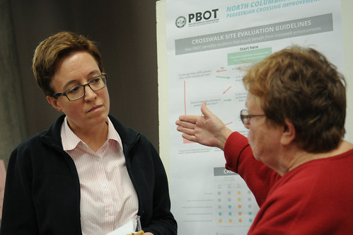
(Photos: J. Maus/BikePortland)
For decades, people who live in a part of St. Johns north of Columbia Boulevard and west of Portland Road have hoped and prayed for street safety improvements. Cut off from nearby schools, markets and restaurants by an urban freeway where people drive large trucks and cars way too fast, residents of this part of our city have been ignored for a long time.
Now, thanks to a $1.5 million set-aside in the recently passed House Bill 2017, changes are finally coming.
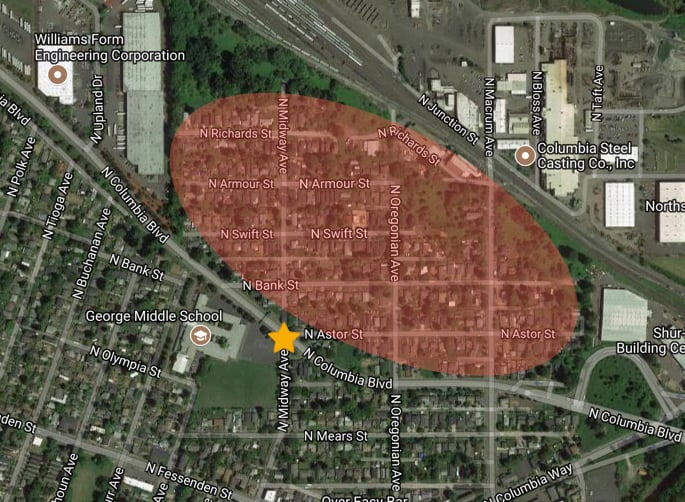
Last night at Roosevelt High School the Portland Bureau of Transportation Director Leah Treat, Portland Public Schools Superintendent Guadalupe Guerrero, and Oregon House Speaker Tina Kotek (who represents this area of north Portland) hosted an event to gather input about how to improve safety at the notorious intersection of Columbia and Midway.
“Now we have some money, so let’s make the best use of it.”
— Tina Kotek, state representative
“None of us who live in north Portland need to be reminded we have a lot of accidents out here,” Speaker Kotek said during her brief remarks, “And now we have some money, so let’s make the best use of it.”
Also speaking last night was a sixth grader from nearby George Middle School. “I’m worried my friends will get hurt because of fast trucks,” she said. And a leader of the PTA at Roosevelt High who lives north of Columbia referred to it as, “A neighborhood that’s completely isolated, like a little island.”
PBOT Director Leah Treat was also in attendance. After saying she, “brought the idea of Vision Zero to the City of Portland” when she became director four years ago, Treat said her agency will request a speed limit reduction on Columbia Blvd and add speed reader boards (signs that tell people how fast they’re going). “We need people to slow down,” Treat told the crowd.
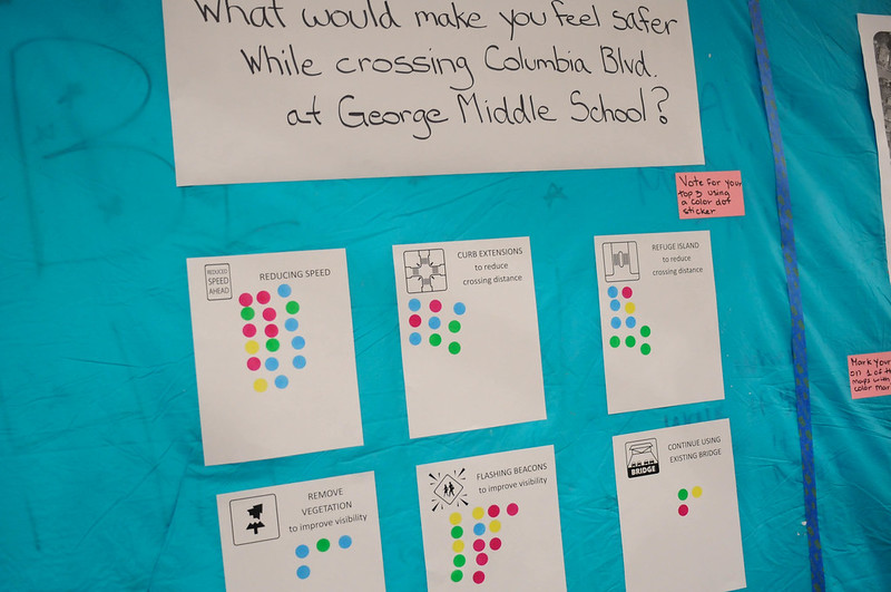
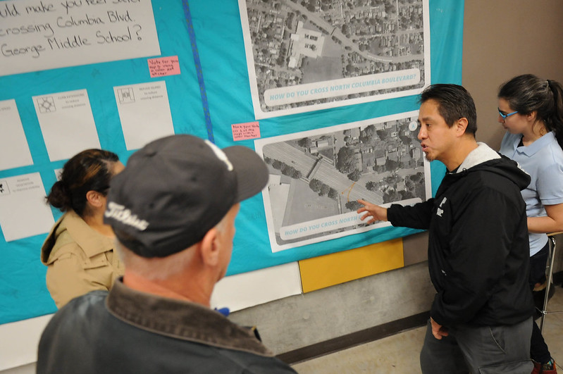
The main focus last night was for people to share feedback on how to make the intersection safer. They did this by having one-on-one conversations with Kotek and city staff around a series of posterboards and interactive displays.
Advertisement
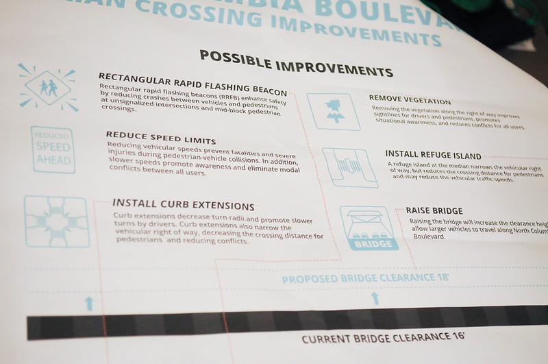
PBOT offered six possible “improvements”: rectangular rapid flash beacon, reduce speed limits, install curb extensions, remove vegetation, install refuge island, and raise the existing, non-motorized bridge overpass. (Noticeably absent from this list were things like a road diet, a roundabout, or a full traffic signal.) According to the amount of dots next to each one, reducing speed limits was the most popular improvement, followed by flashing beacons.
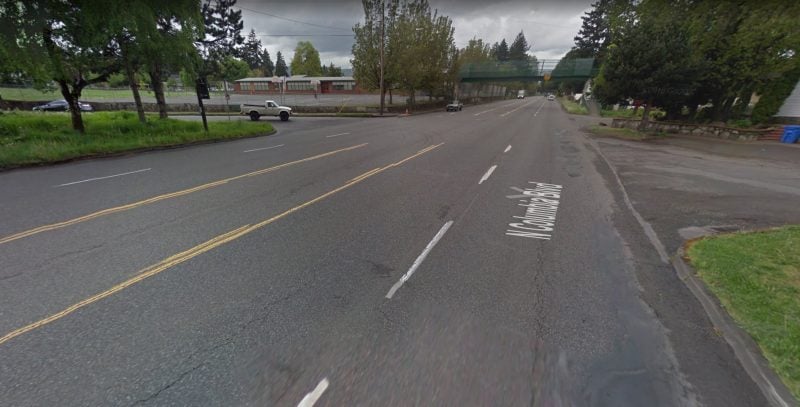
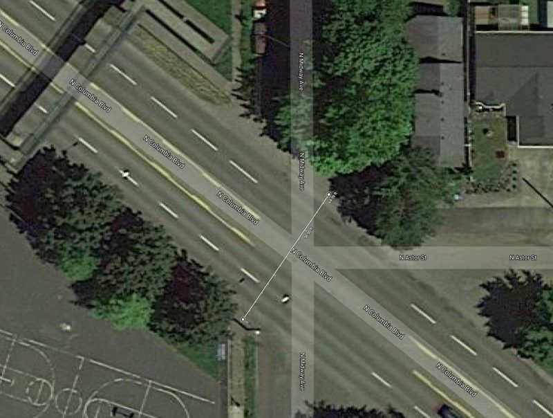
Columbia at Midway is a challenging intersection for many reasons: Depending on where you cross the five daunting lanes, it can be anywhere from 60 to 75-feet from one curb to the other; ibuirgardt’s a major freight route which means the State of Oregon controls much of its fate; Columbia crosses Midway at a diagonal and North Astor (a small residential street) also intersects with it.
I spoke to several people last night who have live north of Columbia. They told harrowing tales.
“One of my friends found a human ear in his yard, and mailed it down to city hall.”
— A man who lives north of Columbia
“It’s a free-for-all,” said one man who has lived in the neighborhood since 1979. He recalled two occasions where he found body parts in the road after a collision. “One of my friends found a human ear in his yard,” he said, “and mailed it down to city hall.” He was very frustrated that nothing has changed with the intersection despite its gruesome history. He and an older woman in her 60s told me the place they’ve lived for over 40 years is often referred to as, “The grey area.” “They don’t know what to do with our streets,” the woman said angrily. “I’m 67 and I have a disability, and I have to walk across Columbia there because I’m too old to use the overpass and there aren’t even sidewalks for me to get to safer crossings.” “There are always meetings like this, but that’s as far as it goes,” the man standing next to her chimed in, “Nothing is going to come from this.”
Trinity Gibbons lives right at the corner of Midway, Columbia and Astor. Gibbons told me she responds to crashes outside her door about twice a month. “It takes seeing someone crash to really understand this. It’s crazy to me.” When she sees kids out in the street, she feels an obligation to tell them to not cross there and use the overpass — but they almost never listen to her. Then she shared a story:
“One weekend there was a whole family out there on bikes. They were lost and looking for Kenton Park (several miles away). I told them to not cross there but they did it anyways. And then there young daughter crashed in the middle of Columbia. I thought, ‘What are we doing here?! This is crazy!’ So I just had to come to this meeting tonight.”
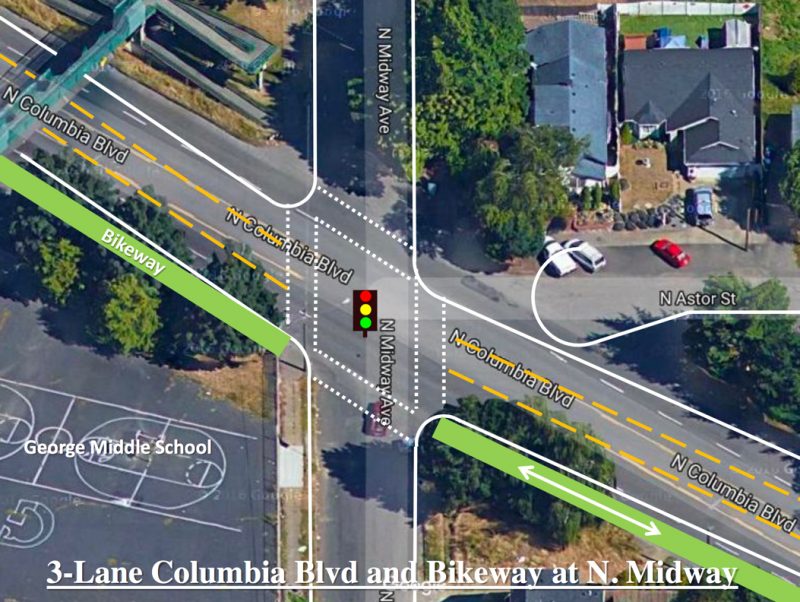
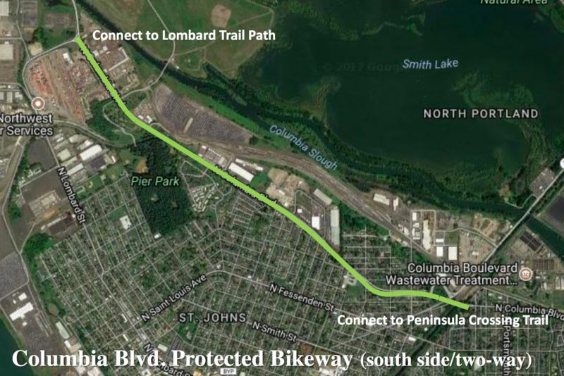
One of Portland’s best transportation thinkers, Jim Howell, was also there last night. He’s shopping around an idea that would tame Columbia for the entire two mile segment between Burgard and Portland Road. Howell’s “Columbia Blvd Safety Plan” (PDF) would: reduce the speed limit to 35 mph (from 40); restripe the road from five standard lanes to three and add a protected, two-way bikeway along the south side; install a traffic signal at Midway (make Astor a cul-de-sac); and improve TriMet bus service. Howell thinks Columbia is “overbuilt” with just 6,000 average daily trips. A high-quality bikeway on Columbia would connect the existing Peninsula Crossing Trail to Chimney and Pier parks and the multi-use path adjacent to Lombard in the Rivergate industrial area that gets people to Kelley Point Park and the 40-mile loop path (see below).
At this point, PBOT is just taking input and it will likely be many months — hopefully not years — before a design is chosen and constructed. And whatever happens is likely to boil down to a persistent nemesis for safer streets throughout Portland: ODOT. The state agency will stand up for “freight interests” if any proposal dares to substantially tame the motorized menace on Columbia.
Stay tuned for more opportunities to get involved as this project moves forward.
— Jonathan Maus: (503) 706-8804, @jonathan_maus on Twitter and jonathan@bikeportland.org
Never miss a story. Sign-up for the daily BP Headlines email.
BikePortland needs your support.


Thanks for reading.
BikePortland has served this community with independent community journalism since 2005. We rely on subscriptions from readers like you to survive. Your financial support is vital in keeping this valuable resource alive and well.
Please subscribe today to strengthen and expand our work.
They already have a drag strip 1/2 mile away at PIR, Columbia doesn’t need to be one too!
I am truly shocked that no one is advocating for sidewalks along Columbia! The pedestrian bridge is very poorly poorly connected to any sidewalks. There are huge stretched of road without sidewalks or with sidewalks on only one side (not very useful if one cannot cross the road!). Jim Howell’s plan is a great start- the bike path should extend a couple of blocks to the east so the Peninsula Crossing trail also connects tothe signal at Portsmouth and the Columbia Slough Trail. A road diet seems like a critical first step here!
Neighbors are advocating for sidewalks.
Yes, people have and do. BDS and PBOT seem to care little about it. I guess they are overwhelmed by the miles of missing sidewalks in this city to ever get to work fixing a few gaps.
Would someone post some of the existing traffic data for this location to make this discussion a bit more grounded:
– ADT (and bike / ped counts) / 85th percentile speeds / crash & fatality rates / enforcement data
[I assume such was collected for last night’s meeting.]
If the current ADT is only 6000 vehicles per day then this 5 lane roadway can very easily be modified by a road diet…our West Fourth Plain Blvd. This is the old primary arterial to Vancouver’s Port/ xSR-501 and was road dieted in ~2002 and it still carries 15,000 to 20,000 cars and trucks per day with 3 lanes + bike lanes…is posted at 25 mph…and has traffic signals with crosswalks etc. (Truck operators still tend to choose it over the 5 lane primary truck route called Mill Plain for many trips.)
Jim Howell must have been looking at the data for only a single direction of travel. The real number is roughly 12,000 ADT if you add up each direction of traffic. Data point was collected in 2016, available to the public here: https://pdx.maps.arcgis.com/apps/webappviewer/index.html?id=7ce8d1f5053141f1bc0f5bd7905351e6
That is still well below the usual 20,000 ADT threshold for being able to do a road diet with no real impact to traffic or freight travel times. Definitely a promising idea! Love the bike path on the south side. Running it from Burgard to Portsmouth would create a continuous bikeway trail connection from Rivergate to Kenton.
a bridge connecting Chimney Park to the former landfill, now Metros ‘St Johns Prairie’ may well provide connection possibilities. I was unable to attend last nights meeting, but I believe the bridge is currently in the design phase, and funding is in place. Not that this would be a complete solution, it might well, with good connections, provide some better access through the parks.
Yes, the project is funded and being constructed by Metro.
It’s absurd to me that a dedicated traffic signal for people who walk or bike wasn’t even presented as an option by PBOT. Far too many drivers speed right through the flashing RRFB signals regardless of whether someone is crossing.
From what I remember, RRFBs were first presented by PBOT as a low-budget option for safety improvements. In this case, they have the budget. If Vision Zero means anything then they should be going with the safest option, full stop.
“Remove vegetation”. Does that mean another war on trees? I thought that removing trees only speeds up the traffic.
Weeds. Grass. The area is not maintained; overgrown; littered; a war zone.
Yes, good idea. I wonder how many planning and listening sessions will be held before someone with a mower, weedwacker, and loppers spends a few hours out there maintaining some of these problem spots.
The risk of severe injury after being struck by an SUV (light truck) at 35 mph is in the ~70-80% range (depending on the study).
Put a full signal at Midway, and make Astor into a cul-de-sac. (Like in Jim Howell’s drawing) And, road diet and bikeway, like Jim’s drawing.
I’d like a road diet and Jim’s plans.
$1.5 million isn’t a lot of money for Portland, especially for a major street like Columbia. Signals are $200,000-$300,000 in Portland (but half that here in NC), while “standard” sidewalks are $5 million/mile without curbs and $1 million/mile with curbs. The road diet idea is probably the most cost-effective, especially with buffered bike lanes, while the side-path bikeway that Howell is proposing is probably cost-prohibitive.
However, a modern roundabout corridor might gain freight route funding due to the reduction in delay. For such a major freight route, time is money, so a center median with modern roundabouts at regular intervals and reduced speeds would likely have less delay than the hurry up and stop model the truckers currently deal with (trucks are more slow to get back up to speed due to weight after a stop). And medians at every minor intersection, along with a road diet, would significantly improve crossing opportunities for pedestrians.
Remove vegetation ? Street trees help with traffic calming.
Where?
Columbia/Midway intersection needs a full signal with curb bumpouts to narrow the road, pedestrian refuge island, really good lighting, and well marked cross walks. Surely $1.5MM will pay for that.
Woah there Jonathan, slow down for a second!
Am I seeing that one of the ideas is to RAISE the pedestrian bridge, to allow bigger trucks on Columbia? I don’t mean to be demanding of my favorite blogger, but WHAT!? This is a pedestrian safety idea? Please help me.
(Or don’t bother, because obviously that’s the one ODOT will do.)
Seriously, can anyone explain this idea?
I am strongly advocating for reducing the speed limit to 35mph, sidewalks to connect our isolated neighborhood to the trails that surround us but we have no access to. I want to se a signal light at Midway and Columbia Blvd. Small median islands in the turning lanes and sidewalks on both sides that actually connect to the trails.
The islands would prevent cars passing on the right while trying to make a left turn in the center lane.
Our 1-1.5 mile stretch needs to look like a real neighborhood exists there and get vehicles to slow down
Thanks to everyone who values safety over trip times.
I live near Columbia and Fessenden and Lombard. I could not make the meeting.
Allow me space to debunk the lawmaker lies.
First do not believe Speaker Tina Kotek. She will lie to get anything passed.
Kotek and every Democrat is playing a game. Every democrat cares 10,000 times more about pavement than this project.
Why do I say they care 10,000 times more?
See below. You can measure their lies in dollars. It’s data.
Kotek has told me to my face that safety questions were answered. These are safety questions from thousands of activists. They were never answered in fact.
Let me quote Kotek: “they didn’t like” her answers. We did not like what she said because it was a pack of lies. You see lying answers are no answer at all. As MLK said: an unjust law is no law at all.
Listen to what North Portland resident and state rep Lew Frederick said:
https://youtu.be/lC3R2IKKGVI?t=2m49s
“real alternatives were frozen out…more of the questions asked should have been answered… I urge a no vote”
Listen to former Metro Council member David Bragdon…. “It(CRC) did not add up..They continually stonewalled” https://youtu.be/Pk1rW5S-S5A?t=1h5m29s
The state is run by Democrats and they instantly pulled out their wallets to spend $5 to $10 Billion. It was a near unanimous yes! They care 10,000 times more about pavement than humans.
Again….Why do I say they care 10,000 times more?
here’s the answer about why they care 10,000 times more about pavement.
Answer. They voted to invest on a freeway just 2 miles from this deadly spot. YES TEN BILLION DOLLARS. That is ten thousand times the cost of this North Portland Project. Ten billion was the total cost according to an economic analysis by safety critics like Joe Cortright. You could have 5,000 to 10,000 safety projects all over Oregon for the cost of adding a few lanes to the freeway near Jantzen Beach. Did they spend years answering questions? NO. – Was there a “lengthy public process”? No. Did they spend years with public votes on the 10 billion? no. Did voters know beforehand how their reps would vote? NO. Did it “solve the problems in the area?” No. Did Kotek lie and say it solved problems? Yes Kotek lies. There was a public hearing Feb11th and Feb18th in Salem and then Feb 25th the house voted yes. The public was told the cost was just a few Billion, but that cost was just the cost to start construction.
http://electjoerowe.com/crc
Watch Kotek lie over and over again about this $10 billion CRC freeway.
Keep up the good work everyone. When I say everyone I mean everyone who cares about safety over trip times. Stop your friends who suffer from the Stockholm syndrome of giving thanks to their lying oppressors.
The same tricks are being used to sell cement caps to cover the freeway near the Rose Quarter at the cost of 450 Million. That means they care 400 times more about cement caps than this project.
Peace out. Safe streets! Joe
They’d have a lot more money for projects like this, if the politicians would reduce / limit the use of studded tires !