The day has finally come: You can now ride your bike in legally-protected, cycling-only space between Davis and the Steel Bridge on Naito Parkway.
Nine years ago (nine!) I lamented this gap after the City of Portland celebrated a $10 million rehab of Naito. All that money and they couldn’t manage to stripe a few tenths of a mile to connect our waterfront bikeway! I wasn’t happy. Here’s what I wrote back then:
While I’m thrilled to see these new bike lanes, and it’s great to have an option off the crowded, multi-use waterfront path, PDOT and/or ODOT should put their heads together and find a way to connect this new bike lane with existing ones just north of the Steel Bridge.
This connection is imperative if the City wants to encourage cycling and it’s the type of thing that can add teeth to their claims of wanting to build a “world-class” bike-friendly city.
Once they close this gap, we’ll really have something to celebrate.
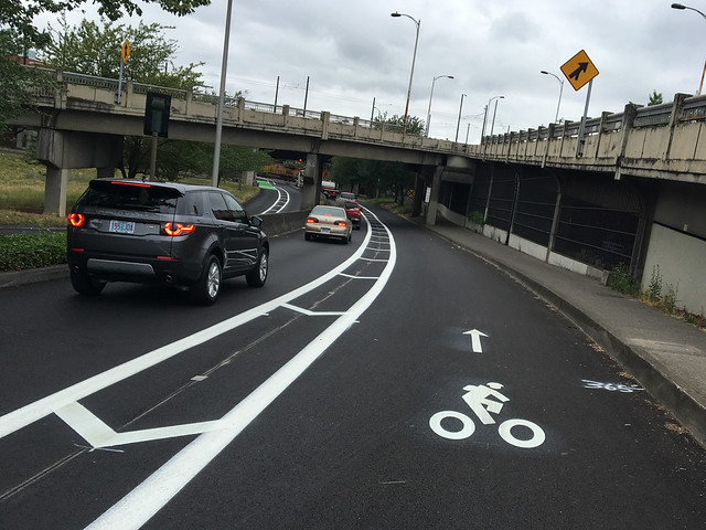
After riding the just-installed bikeway this morning I can finally say it’s time to celebrate. The design isn’t perfect and we’d still prefer physical protection — but this is a huge improvement (and the protection will come later).
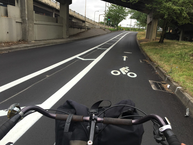
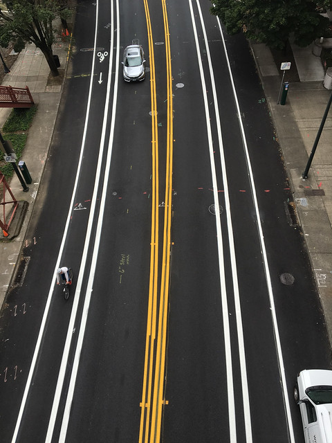
As we reported last week, a repaving project helped the Bureau of Transportation finally get this project done. What we have now isn’t merely a narrow standard bike lane, it’s an entire lane that’s just as wide as the adjacent standard travel lane.
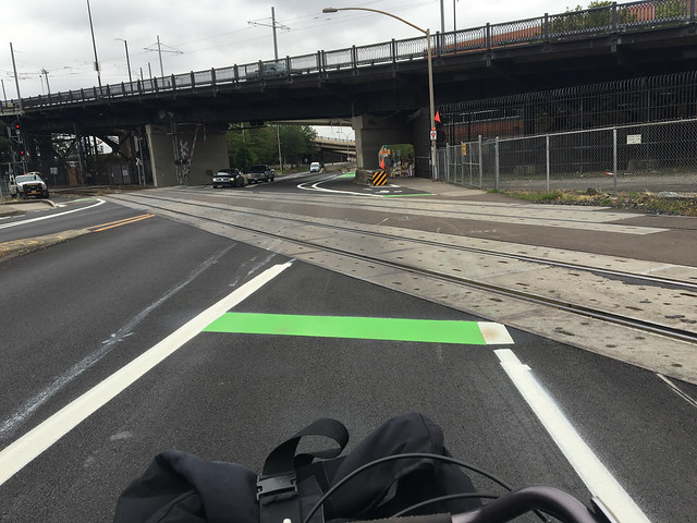
Check out the video below to see what it looks like from a bicycling point-of-view. (Keep in mind that the video is sped-up (for your viewing convenience) and there is a lot more auto traffic than usual because a train had just passed by.)
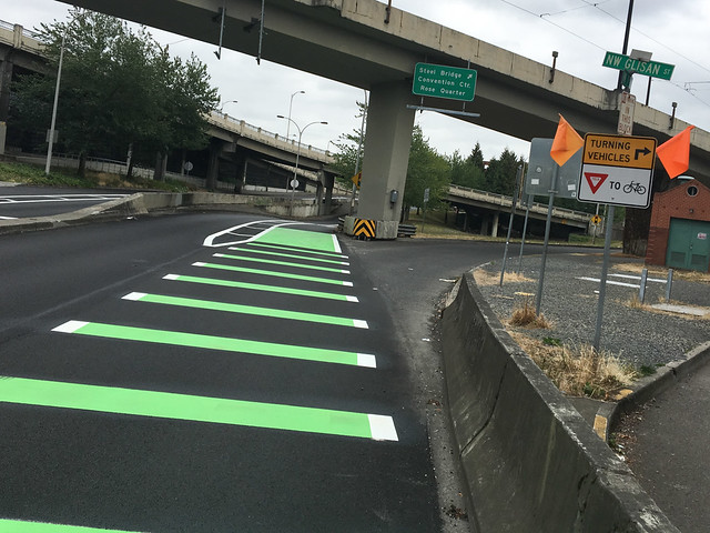
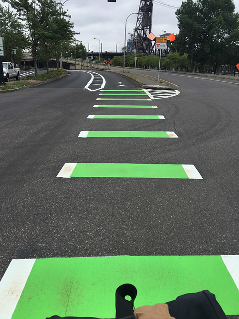
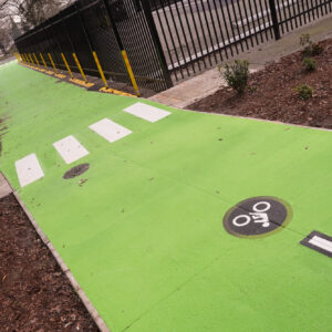
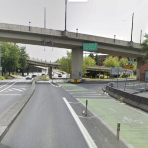
And here are a few photos for closer inspection:
One question people have immediately asked is why there isn’t physical protection to separate car users from bicycle users. We haven’t got the official answer from PBOT yet, but recall that this bikeway was completed as part of a routine restriping that’s taking place after a repaving project. That means the budget and the outreach process is much more limited than if it were approached as a separate project on its own.
The right hook concerns we reported on last week will likely remain. At two locations (one in each direction) people driving on Naito have an option to take an off-ramp that crosses right over the new bikeway. For now these concerns are mitigated by a lot of green-colored paint and yellow caution signs. Given the width of the lanes the visibility of other road users is very high. This distance between users should decrease the chance of collisions.
It’s also worth noting that in addition to these new lanes through the gap, PBOT has widened and bufferized the bike lane on both sides of Naito from the Steel Bridge all the way north to NW 9th.
A few other thoughts:
– I’m still puzzled by PBOT’s reluctance to lay down more bike lane symbols in bike lanes. This is a citywide problem that leads to people driving and parking in bike lanes. With this project there’s only a few bike lane symbols the entire length of the restriping. I’d like to see them every 75 feet or so to really drive the point home that the lane is only for cycling — especially with the lack of physical protection.
– Even with this wide new lane, there’s unfortunately still no safe way to cross Naito (on foot or by bike). Many people make a risky dash across the street to connect from the popular Waterfront Park/Steel Bridge path to Flanders and Old Town. Having only one lane for driving vastly increases the crossing safety, but we must address this in a more comprehensive way someday.
– With people now used to the two-way bikeway “Better Naito” configuration to the south, the sudden one-way of this new section might be confusing. I can envision people dropping in from the Waterfront Park path at the Steel Bridge and going southbound (the wrong direction) in the northbound bike lane.
– Speaking of Better Naito, this improved bike lane should add to the political momentum to keep Better Naito beyond its demonstration phase. The quality of bike networks are only as good as their weakest link and to return Naito to its pre-Better Naito form would be a major step backwards.
Roll over and give it a try. We’d love to know what you think.
— Jonathan Maus, (503) 706-8804 – jonathan@bikeportland.org
Our work is supported by subscribers. Please become one today.



Thanks for reading.
BikePortland has served this community with independent community journalism since 2005. We rely on subscriptions from readers like you to survive. Your financial support is vital in keeping this valuable resource alive and well.
Please subscribe today to strengthen and expand our work.
Keep it up PBOT! Thank you!
This is a great start! Hooray for NW (and anyone North of Downtown)! Can you explain the differences in ROW jurisdictions along this stretch for PBOT/ODOT, etc.? How does it differ from implementing the same concept along the Barbur Bridges where ODOT has Barbur & PBOT has Capitol Hwy? BTW, for anyone who experiences Barbur it’s interesting to see the already crumbling asphalt less than 2 years after the bridge rehab/repave. And finally, how is that conversation w/ ODOT going?
hi phil,
from what I know PBOT owns the road the entire way… But ODOT rail is in charge of the rail crossing. That’s been a hurdle because this project has always had to figure in the railroad discussion and get sign-off from ODOT. As for your question on Barbur. Michael has an update on that coming up soon. We had to do some information requests to get what we want from ODOT and PBOT but hopefully we’ll be able to report something soon.
Not enough bike vinyls, really needs some sort of physical separation, and there’s a misplaced vinyl:
Or someone has a clue afterall regarding parking protected bike lanes…
I thought that too at first but realized it’s an old one they haven’t removed yet…
It’s new pavement, so doesn’t make sense for it to be an old one. Plus it appears there wasn’t one at that specific location anyhow:
https://goo.gl/VqPdib
I can answer to this stencil, as I live on NW Naito. When the city repaved Naito, they only “penciled in” the lane markings on chalk or some such thing until their thermoplastic crew could get out to permanently stripe the lanes.
So, for a couple of months, the new pavement was laid down, but no permanent striping, only little chalk looking lines laid down to show where the striping would go.
HOWEVER! The chalk lines laid down were for the OLD lane configurations without the new bike lanes. I guess the city hadn’t yet gotten signoff to install the new bike lanes, and so was planning on just restriping the road as before.
The ONE bit of thermoplastic they laid down after repaving was the bike lane stencils. So, even tho the lanes themselves were only chalked out, they did lay down permanent bike lane markings.
That lane is too wide to not have physical separation. It needs plastic bollards or some other kind of vertical deliniation. If the lane is wide enough to fit a car, you’d better believe people will drive in it.
Agree, it is way to wide for one way travel and no protection. Seems they split the buffer area between the two travel lanes. Would have been more appropriate for the entire buffer to be taken from the right lane only (so bike lane and buffer area combined is same width of motor lane).
It’s not your
spacelane to own or saywhat color bike racks are installed in it.how it should be striped.The NIMBYs are everywhere!
I rode this yesterday for the first time. Even though the entire bike lane was mine, I kept close to the right for fear vehicles behind me would not realize it was a bike lane.
9 years? I thought people have waited for this since the Harbour Freeway was first plowed through downtown.
Well, 9 years since Jon wrote about it. But yes, we’ve been waiting for it a lot longer than that. I commuted to outer Naito (then Front Ave) from 2000-2003 and was always frustrated by this gap – as well as others that still existed the, but this one was pretty bad.
Yesterday I watched frustrated drivers waiting in line in the southbound car lane. Some of them decided to use the new wide green bike lane to continue under the bridge. I’d encourage you to check it out during rush hour and see if you have the same pleasant experience.
It does look like a very nice “shared” bike/HOV lane. Perhaps the police can use it as a sting trap?
This will become quite common, I guarantee you. I travel to L.A. a lot and it is the ‘rule’ there for cars to make a turn lane out of bike lanes. You see dozens of cars per hour bypassing blocks of backed-up traffic to make their turn. I see it starting to happen in Bend now, where I live. Bend’s traffic has surged dramatically the past two years, so cars are taking the path of least resistance. Since enough cops will never be available to enforce the bike lane protection, the only solution is bollards.
I noticed this in West Hollywood in LA last weekend, and then again in Portland yesterday around 5pm on NE 15th with folks in cars driving north and getting into the nice new big bike lanes just before Halsey to make a right turn onto Weidler.
That being said, I prefer the big bike lanes to small bike lanes. And I suspect I’ll prefer physically separated bike lanes to big bike lanes.
Part of it is just common sense and human nature. In L.A., I ride in the South Bay and you might see one bike every 10 or 15 minutes in the bike lane, as opposed to 10-20 cars/minute. If I was a driver, and I had the choice of waiting 1 or 2 minutes to make my right turn, or take a virtually unused bike lane, I would probably do the same thing, even though 95% of my commuting is by bike. I’m not defending it, just reality. Unless police were to give tickets for such behavior (never going to happen in L.A., doubtful in PDX), this will become the norm. It’s hard to defend a single-use lane that rarely gets used, when cars are backed up with frustrated drivers, polluting the air. This has always been my objection to bike lanes.
it’s a catch-22. bicyclists ride on the sidewalk on Wilshire because they are too scared to take the lane (which is now bike+bus+car right turn only). Or they’d take the nearby sharrow street, which hit a tee and disappears.
‘polluting the air’ is the argument against HOV lanes. not gonna touch that.
For better or worse (I think better, but some may disagree), that is the rule just about everywhere.
It sounds like bollards here would be needed?
I hope you passed on this concern to engineering at the City? Preferably with a photo.
Yeah, honestly this lane is too wide. If it’s wide enough for a car to fit in comfortably, people will drive in it. I actually think it would work better to stripe one wider car lane and than a narrower bike lane that clearly couldn’t accommodate a car…
Seems like the rail crossings promote crossing at a safer angle but at the expense of having to immediately avoid hitting curbs / barriers. Hopefully people will use their own judgement here and not focus on “staying in the lines” at all costs.
Also missed a good opportunity to have the bike lane be parking protected and against the curb north of the rail crossing. And of course the buffer area is between bikes and traffic and not in the door zone as it should be.
Where there is a landscaped median, the street isn’t wide enough for parking-protected bike lanes. Hopefully in the future it could be modified.
And I think I agree regarding where to place the buffer space.
Rode it for the first time Thursday, and a truck apparently did not understand it was a bike lane (he drove the whole length of the new bike lane). That said, it’s a good addition and I’m happy PDOT has done something.
Guess it was one of those old dumb trucks;-) I rode through there yesterday. As Adam and various other people commented above, in America this plays as a car lane weirdly seperated by fat white stripes. Those bike symbols must be new kind of share-thingy. Roll the hilarity.
Yikes, that northbound exit only lane crossing looks about a sketchy as I imagined…
Especially with those bollards between the motor lanes essentially forcing cars closer to the bike lane.
By bollards you mean the temporary better naito cones closing the right lane to cars.
Doh!
Forgot about that. Assumed the cones were being used to help signal an exit only lane until more pavement markings were put down.
On right hook risk, you said “Given the width of the lanes the visibility of other road users is very high. This distance between users should decrease the chance of collisions.”
As an semi-unreconstructed vehicular cyclist, I cringe at that second sentence. Doesn’t more distance between a car and a bike (still close to the curb) increase the right hook risk in an unprotected lane?
Also, the sped-up video seems to portray the viewpoint of a not that rare 15mph cyclist.
While there is a still much research going on in the world of bikeway design, the evidence seems to indicate that increased separation between the bikeway and the roadway can improve safety over immediately adjacent bike lanes. Separating the bike lane by 6.5 to 15.5 ft through an intersection allows drivers to yield to people bicycling during a right turn movement.
If you want to dig in, see Paul Schepers Road factors and bicycle-motor vehicle crashes at unsignalized priority junctions, 2011.
Personally, the more room I had as a cyclist the greater the chance I could avoid a right hook.
Of course, if I was paying attention I wouldn’t be in a bike lane at a dangerous intersection anyway.
So, in the 2035 plan, the ramp from Naito to the Steel bridge is marked as a “Major City Bikeway” which requires that they “should be designed to accommodate large volumes of bicyclists, to maximize their comfort and to minimize delays by emphasizing the movement of bicycles.”
But the bridge sidewalk is not wide enough. Will that require getting rid of the auto lane and making the top deck of the Steel bridge public transportation and bike only (Eastbound)?
This relates to this project, because the ramp could be closed now, with no big issues (and it would make it safer for people biking)
The rest of the description of major city bikeways:
“Build the highest quality bikeway facilities. Motor vehicle lanes and on-street parking may be removed on Major City Bikeways to provide needed width for separated-in-roadway facilities where compatible with adjacent land uses and only after performing careful analysis to determine potential impacts to the essential movement of all modes. Where improvements to the bicycling environment are needed but the ability to reallocate road space is limited, consider alternative approaches that include property acquisition, parallel routes and/or less desirable facilities. On Major City Bikeways developed as shared roadways, use all appropriate tools to achieve recommended performance guidelines. Where conditions warrant and where practical, Major City Bikeways should have separated facilities for bicycles and pedestrians.”
>the ramp could be closed now
Has a careful analysis to determine potential impacts to the essential movement of all modes been performed?
Speaking of the ramp, I have yet to meet any humans who have actually driven on one of the Steel bridge ramps. I certainly haven’t, and have lived here for over 15 years.
I personally have (once or twice), and I know plenty of bus drivers who do 😉
The “careful analysis” is happening at the same time as the explanation of why this new bike lane was not protected – so, never.
Looks like quite an improvement.
I’d like to see on the NB side, a ramp that goes from the bike lane to the sidewalk. It seems to me that the angle is a tad too shallow, and a person experiencing a problem after crossing the tracks *MIGHT* need the extra room to recover. That curb prevents that from happening.
That curb is a ramp from the sidewalk to the bike lane.
Please point me at the kickstarter to pay for some rubber curbs and flexi-posts. Also the south end.
Checked it out yesterday during PM rush hour. Cars now limited to one lane were not at all backed up leading to the northbound railroad road dip under the bridge and great that cyclists can now easily attack the tracks at a right angle. Yes, thanks PBOT!
I love that race pace video! I cringed every time you did the wiggle on the train tracks. 🙂
I’m unimpressed as can be. The substandard right-hook lane is a death waiting to happen, likely to someone newly-relocated to PDX.
I’m trying to imagine dealing with that curb that’s less than eight feet from the tracks on my tandem. Admittedly, that one might be doable by using the entire buffer space, but why did someone make the buffer such that it puts a cyclist on a collision course with the overly-all curb after crossing the tracks? Don’t the folks designing these things even ride? Yes, for now they claim to not have the funds to remove that curb and part of the sidewalk to make that crossing safe, but that’s coming off as just more of the same service to motorists while active transportation gets leftovers and should be grateful.
I’ve thought for a long time anyone with right hook concerns would be wise to have a rear-view mirror, they may look “dorky,” but better dorky than injured/dead. They also don’t eliminate the risk, but they sure to help with full roadway awareness and can help enhance communication with others using the road.
What works even better than a mirror is roadway designs that don’t put through lanes to the right of bearing-right lanes, creating inherent conflicts and ensuring approaching cyclists are in the blind spot of drivers.
How much of the sidewalk do you think needs to be removed? Just the ramp for bikes coming off it?
http://imgur.com/G8iqM3D
PBOT should have a quarterly group ride of their designs with all of their engineering staff, managers, and directors. At a minimum 15mph pace, electric assist. Managers and lead engineers must ride cargo bikes, box trikes, etc.
Hey Jonathan, thanks for the video ride of this new segment. This plus still images Illustrates the changes perfectly. Much appreciated.
drove next to it today and saw a few bikes and no cars in it…
agree that it needs more stencils, like every other bike lane in the city…
I love all that fresh green paint. Thanks, PBOT!
Huge improvement. Big thank you to PBOT. Safety will depend a lot on how vehicle speeds are thru there. Posted 40 mph a stone’s throw north (!) doesn’t help. Word on the goofy little ramp with the nasty curb you smack NB after the tracks is it will have to wait for $. Also I’m told the current ped/bike path east of the bridge footing will be ELIMINATED (?!) with the upcoming Flanders project. If so it’s very unclear to me how peds could possibly mix w/ bikes in the bike lane there. Keep your eye out for that as a possible big step backward soon.
It’s not being eliminated. It’s being relocated closer to Naito Parkway so that the crossings can be consolidated as part of the future improvements.
http://bikeportland.org/2015/12/08/169829-169829
I wish there were more bike stencils in the bike lanes. They are wide enough to look like car lanes.
Also, why no striping across the railway tracks? Without that, people who don’t know to ride perpendicular will wipe out by the dozen.
The “Turning Vehicles yield to bikes” signs need to be much larger. With all the distractions a MV driver has to deal with, I would think these are something for bikes to read,at a quick glance up from my texting, eating, knitting etc while driving, and thus ignore them.
Great job. Goes to show how much work it is to realign a road.
I think they should preserve the usable right-of-way for first responders here, so maybe we could have some retracting bollards to permit only bikes in this lane but can be dropped on command for special needs. You see these all over Europe and is an excellent solution for maintaining the integrity of the network while allowing only bikes to pass thru. Much better than permanent diverters and barrels eg: Clinton and Akeny now.
I believe most diverters are low enough that a fire truck can pass over them unimpeded. Since a fire truck is a first responder vehicle (they typically will get there before police or ambulance), they’re really not a problem.
Plus, bikeways with diverters are NOT emergency responder routes by definition. If they were on emergency responder routes, a diverter would not be allowed (see NW Overton as an example. A frustrating example, but an example nonetheless).
The barrel diverters now being installed are certainly fixed obstructions. I am just suggesting that we preserve the network integrity. Someday we may need that access
If we really want to improve “network integrity” then what we really need to be doing is removing the utter gridlock of motor vehicles on our streets. This poses WAY more of an impediment to emergency responders than a diverter.
The irony of course, is that a diverter is really one of the ONLY ways to tackle that gridlock by getting people out of their cars and onto bikes. Most people will not ride bikes on roads with car traffic, period.
k,
test diverters are usually not designed for ER access like the permanent versions, and PBOT will stop using the tall planters for future tests.
Look at that width… and hashed buffers the whole way? Man, you Portlanders are spoiled!! 😉
I was going to add that the lane is actually too wide so that drivers will frequently use it as their own private lane, but some comments seem to confirm my suspicion is right.
It looks very wide, but maybe for better protection they could’ve made the lane another color like red. I’ve seen that a lot in the netherlands where the lanes are alot smaller.
Red is not allowed in the US. Green is the bike lane color.
In the US, red is for bus lanes.
Wide Lane:
I get the potential confusion — especially for tourist. If the bike lane markings are to look so similar to sharrow markings and there is a precedent for two lanes/one shared (the St. Johns Bridge)… What’s clear to us, is not always clear to even daily drivers in Portland.
RE: width, this same discussion is probably archived somewhere on BP after the Vancouver bike lane was widened. 2 meter bike lanes – 6 feet, 6 inches – is the current preferred minimum for PBOT.
I like the new lane at the Naito Gap and agree they should put more symbols in bike lanes as people driving/parking in them is an issue, but am I the only one here who actually prefers the pre Better Naito configuration?
In all honesty I felt considerably safer the old way. Under the Better Naito, a lot of cyclists treat the bike lane as a through lane and go against lights at speed without even looking for peds or cyclists who have right of way. With only one lane of slow moving traffic, I also see a lot of cyclists not sweat waiting for a light before zooming in, often without paying attention. Meanwhile, some of the oncoming cyclists meander like stray chickens. It amazes me that I haven’t witnessed any collisions yet.
With the old configuration, the cars are very predictable on that particular stretch and it was a very decent section overall.
Frankly, I’d never had any safety concerns until it was Better Naito and won’t be at all sad if they flip it back the way it was.
I enjoyed riding south-bound on it yesterday in order to get to the Steel Bridge.
how about the traffic calming, though?
Shout out to the properly hashed buffers!
Makes a HUGE difference. Thanks PBOT!
I have noticed an unintended consequence of the new Naito Gap bikeway. When a train is blocking the roadway, some drivers are now backing up into the bikeway and driving in reverse to get to Couch Street, so they can avoid the backup caused by the train. This is an illegal and highly dangerous behavior. Drivers can’t see as well out their rear window. It is hard to judge speed if the driver is backing up while a cyclist is riding towards them. The bike lane is as wide as a car lane, so it invites this kind of behavior.
PBOT needs to put something in the buffer area to prevent this. Either flexible bollards, a tuff-curb installation (like on the Hawthorne viaduct), or poured concrete. Anything that will prevent or highly discourage drivers from entering the bike lane will suffice.
All in all, I think the Naito gap bikeway is a huge safety improvement over what was there before. It just needs a bit more to be world-class.
Yep. Wide bike lanes look like a great spillover car lane. That’s the problem with only having paint.
I do love riding on it, though. I have skinnier tires so I have to go fairly perpendicular to the tracks, commanding a lane from drivers and then swerving was always confusing.