(Graphics: Multnomah County)
Multnomah County announced today that the new multi-use path being built as part of the Sellwood Bridge project would open on Tuesday, June 14th.
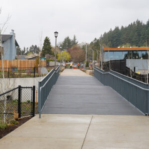
The new path on the west side of the bridge will be 14-feet wide and head north to connect with SW Miles Place and Willamette Park. This will come as very welcome news to everyone who has experienced the detour that put bicycle riders on a narrow sidewalk of SW Macadam.
The new path currently connects only to the north side of the Sellwood Bridge. A connection to the southern path of the bridge remains closed until the County finishes a new bridge that will take riders and walkers up to the deck.
Here’s more from the County:
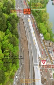
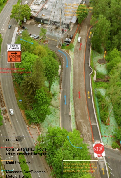
Signs will direct trail users to access the trail from SW Miles Place. At first, some southbound trail users may access the trail from SW Macadam via the Macadam Bay driveway, because the current path is on the SW Macadam sidewalk, which will now end at the driveway. Eventually, trail users will get used to the new alignment from Willamette Park to the bridge.
Users of the new trail will need to yield to construction vehicles where the trail crosses the construction road just north of the bridge. There is also four-way stop where the trail intersects with the Macadam Bay driveway. When the historic trolley service returns in 2017, trail users will need to yield at the trolley crossing.
Advertisement

The northern terminus of the new path is SW Miles Place, a small residential street. In 2012 there was discussion about restriping the street to accommodate the increase in bicycle riders expected with the new path and bridge.
Before the new bridge opened about 300 people per day used the westside path. A consultant hired by the County in 2013 estimated that that number would increase to 900-1,200 users perday once the bridge opens. That same consultant said bridge crossings by people on bike and foot could reach 9,000 per day by 2035.
According to Pullen, there are no changes planned for SW Miles Place. Concerned about collisions and safety, people who live on the street successfully lobbied the City of Portland to not install any new pavement markings such as striped bicycle lanes or sharrows. The Portland Bureau of Transportation will monitor traffic on the streets and will reconsider design changes if warranted.
This is the second bit of good news this week for the Willamette Greenway Trail. On Monday we reported that automobile manufacturer Tesla agreed to pave a path across a parcel they’ve purchased for a new showroom in South Waterfront. Because of a code exception, the company wasn’t legally required to do so.
The new path opens Tuesday and the bridge from the path up to the south side of the main bridge deck will open by the end of October.
Update 6/13: It’ll be open by noon on Tuesday 6/14.
Update 6/14: It’s now been re-closed for a few more weeks due to remaining cleanup work.
— Jonathan Maus, (503) 706-8804 – jonathan@bikeportland.org
Our work is supported by subscribers. Please become one today.


Thanks for reading.
BikePortland has served this community with independent community journalism since 2005. We rely on subscriptions from readers like you to survive. Your financial support is vital in keeping this valuable resource alive and well.
Please subscribe today to strengthen and expand our work.
This is great – I wish it could be extended down to Lake Oswego on the rail line.
Yes!
Lots of people wish that would happen.
http://bikeportland.org/2015/01/22/lake-oswego-city-council-revives-concept-bike-path-old-trolleyway-131280
Yes!
Full details of the status of the Sellwood Bridge project can be found at the Multnomah County website sellwoodbridge.org – including work on the removal of the old bridge, which is rapidly gaining momentum.
I’m glad Miles Place will remain much as it was before this project started–a true, shared street, and about the closest thing Portland has to a “woonerf”.
While this path will be a nice alternative to Macadam on a sunny day in the summer, ODOT/Multnomah County is not providing this as an “alternative” to Madacam. It will be the only way.
Previously, there was about 1/4 mile of sidewalk on Macadam south of the Macadam Bay driveway, along Macadam itself. While the walk did not lead clear to the bridge, it provided a place the project could have improved clear to the bridge, as well as providing the path down below Macadam along Miles Place.
But, the project is, at the last plans I saw, removing all that sidewalk south of the Macadam Bay driveway along Macadam.
As we’ve seen with the Springwater, an isolated path through the woods is sometimes not the safest choice at night, or at other times when there are not a lot of users, nor any “eyes on the street” courtesy of passing motorists. As you can see by the construction of the ramps just north of the bridge, the project tries it’s best to force all non-auto users to the path down by the railroad tracks.
I wonder how long it will be before we see the sort of unsafe interactions down there that we are now seeing on the Springwater. It wouldn’t have added much to the cost to allow both alternatives, but the “get cyclists and walkers safely out of the way” mentality may end up putting them in a different danger.
The path will likely be more busy than ever, especially with the added businesses and housing in South Portland. There are more logical reasons than ever for a rails-to-trails project for the rusting Willamette Shore Trolley.
Here’s a view from the Freeman Motors/ Macadam Bay driveway looking south along Macadam, with the existing sidewalk leading toward the bridge, which is slated for removal.
https://goo.gl/maps/EFEYGPjLhx12
Can’t wait to ride on this!
Great news, but why the opposition to markings on Miles Place? There’s no incentive to “trap” people there, so you might as well guide them through.
Why would not having sharrows trap people?
The idea of not striping at the outset is that there’s no need to “guide” people through this short street, and the stripes confusingly try to segregate users into lanes according to mode, on a street that’s too narrow for that to work, and isn’t necessary or desirable anyway. If it’s determined after the trail opens that some striping or markings would be helpful, then they can be added.
What a bizarre thing to say– I must admit that I have not yet experienced this flavor of mental gymnastics. Sure, it’s a short segment, but it feels like an apartment complex driveway, not a continuation of a recommended bike path. Wouldn’t be surprised if users are confused and turn up to Macadam to try and continue southward.
And I’m curious as to what the residents’ concerns were. Rejecting a few harmless shadows kind of suggests NIMBYism, unless you’ve got another creative interpretation for us to consider.
Well, if it’s bizarre, it’s a bizarre idea shared by lots of people involved in the project, included the County and PBOT.
And as I said, the striping and signage weren’t limited to way-finding. Most of it was devoted to dividing the narrow street–barely over one lane wide– into separate lanes for different modes. Each “lane” was too small to accommodate the use designated for it. So, for example, if two cars were passing, or even a car and a bike, one would have to drive into the “pedestrian lane”. And the pedestrian lanes were so narrow groups of runners or walkers wouldn’t fit in them, even if people restricted themselves to running or walking at the edges of the street.
The reality is all modes will be on all areas of the street, so any pavement markings should acknowledge that, rather than pretend it’s not going to be true.
Also, there are already directional/informational signs with arrows showing people which way to travel. Even without them, at the point someone would be able to turn (at Miles Street) to make a wrong turn towards Macadam, they are literally two houses away from the park entrance straight ahead, which itself is getting two large entry pylons and new signage to highlight it. Given that, plus the new signage that’s already there, you’d have to be almost blind to make a wrong turn.
Finally, nobody is even saying the striping and pavement markings are certainly wrong, they’re just saying why not wait until the trail is open before spending all the money on markings that may not be right? The street has functioned as a heavily-used trail for decades without any pavement markings at all, and there won’t immediately be thousands of bikes coming through, so why not wait a bit to observe the actual use, before spending all the money on a design that may not be right?
I don’t see why any of that is “bizarre” or requires “mental gymnastics” to think it makes sense. And neither does the County or PBOT.
And I have no idea what you mean by, “Rejecting a few harmless shadows kind of suggests NIMBYism”.
FWIW I think the current no-markings setup on Miles Pl works perfectly fine as it is.
Yay! I’ll be on it tomorrow.
Glad this is finally going to be open. The Macadam sidewalk is pretty sucktastic, although I’m still not thrilled to hear that it will be removed.
So the Willamette Shore Trolley is going to start back up next year? Glad to hear it. I was disappointed when it stopped running (maybe 8 years ago?), because I enjoyed taking my young child on it, and watching it run past my front “yard” when I lived in Johns Landing.
Obviously I’m torn about having the trolley back, because it probably precludes that ROW turning into a path to Lake Oswego. But given how resistant property owners along the route have been towards resumed rail service, I’m guessing it would take 20 years to get that path built, if it even happens.
SW Miles Place only has ~20 home and very low motor vehicle traffic so it will essentially serve as a 20ft wide multi-use path extension of the Sellwood Bridge MUP into to Willamette Park/SW Idaho Street.
I’ve encountered a car almost every time I’ve been through there. It’s more like a parking lot, which is about 1/Nth as safe as a multi-use path.
That rail line would sure be a nice flat, straight line into the moody bikeway if we could bypass the south waterfront parking lot (aka the “bike lane” on bond.) Until the hill starts climbing toward I5, macadam would be a nice connection.
Traffic count on Miles Pl. has been measured by the bridge project at 1 car every several minutes, so it’s a pretty quiet parking lot.
Are there any plans to improve the bike path through Willamette Park as well as along the river? I’ve ridden that part a couple of times and the path is very rough compared to the Springwater.
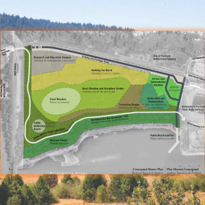
Yes. Parks has a new design ready to build. As you enter the park from Miles Place heading north, you will make a sharp left turn onto a new, much wider path going along the west side of the grass field. Then at the new pump station, you will go onto the existing road northbound past the tennis courts. Bikes will be discouraged from using the trail along the waterfront.
FINALLLLLLLLLY
Just got an update from the bridge project that trail opening is delayed 2 to 4 weeks:
The westside regional trail between the Sellwood Bridge and SW Miles Place will not be opening for two to four weeks. The trail was scheduled to open today but an inspection revealed there is still some clean up work to be done on and near the trail. To ensure safety for the public and workers, the trail will need to remain closed during this work. Due to the number of subcontractors involved, we estimate the work will be done in two to four weeks. The old trail detour route along the east side of Highway 43/Macadam will remain open during this time. We regret the delay.
Oops. The county just announced a delay. Here’s what Mike Pullen sent out Tuesday afternoon:
“The westside regional trail between the Sellwood Bridge and SW Miles Place will not be opening for two to four weeks. The trail was scheduled to open today but an inspection revealed there is still some clean up work to be done on and near the trail. To ensure safety for the public and workers, the trail will need to remain closed during this work. Due to the number of subcontractors involved, we estimate the work will be done in two to four weeks. The old trail detour route along the east side of Highway 43/Macadam will remain open during this time. We regret the delay.”
The trail was scheduled to open in April. Then April passed, and May, and on June 10th it was announced it would open today. Then today it’s announced it will be 2 to 4 weeks from now. Announcing on opening day, “Oops, we’re off by maybe a month” is sloppy. It seems like project management isn’t very good, or maybe the trail just isn’t a priority for the project.
And yet the bridge opened early to Lake Oswego car commuters despite the roadway not even being completed.
Well, these are hard-working people who spend $1.25 or more on every gallon of gasoline. They also have to pay some hundreds of dollars per year of tax on their cars, so they’re entitled to unfettered use of 99% of our rights-of-way. How you pay a tax on bike tires to demonstrate that you’re playing the game just like everyone else? (This tax would need to cover around 10% of the damage done, just like the car use fees… so cough up your penny or get off the road.)