
people at the entrance to SW Miles Place.
(Photo © J. Maus/BikePortland)
Tomorrow night, Multnomah County will hold a public meeting to discuss the future SW Miles Place Regional Trail. As part of the Sellwood Bridge Project, the County has decided to connect the path on the west end of the bridge to the existing Willamette Greenway Trail from the Macadam Bay houseboat community just north of the bridge, to Willamette Park.
Currently, SW Miles Place is a quaint, quiet, potholed and under-developed street that consists of a few dozen single-family homes nestled between Highway 43 and the Willamette River. Back in June, residents successfully stopped the County from routing auto traffic from the houseboat community down the street. Now the big question is: How should the County re-design the road for the increased bicycle traffic expected once the bridge opens?
Miles Place resident Roger Robinson said he and his neighbors are worried that their quiet street might turn into a thoroughfare for bike “commuters”. Robinson sees “commuters” as distinctly different than “pleasure bikers”. He’s worried that if Miles Place gets repaved and has sidewalks and sharrows added to it, people on bikes would zoom through too fast.
Instead of encouraging all bike traffic to use Miles Place, Robinson says he and a group of residents will urge the County to also build a bike path on the Willamette Shoreline Trolley right-of-way. “We’re going to push for that,” Robinson told me on the phone today. Robinson would like to see the County provide separate paths for “pleasure bikers” and more A-to-B minded bike commuters.
“The neighborhood would like the commuters to slow down just like the pleasure bikers do, as speeding through such a small neighborhood can be extremely dangerous.”
If the County does route all bike traffic through Miles Place, Robinson said they’ll ask that everyone obeys the 5 mph speed limit the neighborhood urges all auto users to observe. “Everybody in our neighborhood is concerned about safety,” he says, “… at times commuter bikes try to come through the neighborhood with no respect for the slow speeds necessary to navigate the neighborhood safely. We want to insure that any increase in commuter traffic must slow down to the 5mph that all cars now observe.”
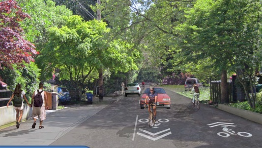
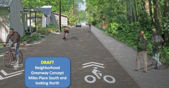
So far, exactly how Miles Place is redesigned is up in the air. Will it get minor repaving to smooth out a few rough spots? Or will it get a full re-do, with new sidewalks, lighting, paving, stormwater collection features, and so on? If a significant redesign happens, will residents maintain the existing on-street parking they enjoy? Will trees have to be removed? Should different modes be separated or would a more mixed environment (like a “woonerf“) be more appropriate?
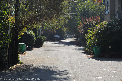
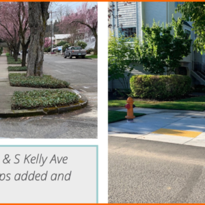
Here’s Miles Place today, looking south:
And here’s a draft mock-up from the County showing what new features would look like:
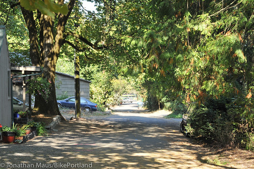
And here’s Miles Place today, looking north:
And the draft mock-up:
Not mentioned much officially (at least so far), is Robinson’s idea of pushing for the Willamette Shoreline Trail. That project was once considered by Metro as part of the Lake Oswego Streetcar project. Ultimately Metro “punted” on the project due to cost and right-of-way acquisition concerns (read more at PortlandTransport.com). Is now the time to resurrect that idea and push it forward?
Come to tomorrow’s meeting to learn more about this project and share your input.
-
SW Miles Place Regional Trail Public Meeting
October 17th from 5:30 to 8:00 pm
Easter Seals Building (5757 SW Macadam Ave)
More info contact Mike Pullen at mike.j.pullen@multco.us




Thanks for reading.
BikePortland has served this community with independent community journalism since 2005. We rely on subscriptions from readers like you to survive. Your financial support is vital in keeping this valuable resource alive and well.
Please subscribe today to strengthen and expand our work.
riders can go slow, sometimes the biggest factor is ppl not paying attention and getting spooked eazy, or walk out into path without looking.
bells,horns,hello’s sometimes help but the 2 modes sometimes have issues with eachother.
Can firetrucks get through there?
I’ve never thought about that on my occasional walks through that area, and I usually think of worst-case scenarios all the time. Most days there are a lot more residents parked cars on the street than the picture indicates, so it’s even tighter than that.
But can a fire truck get through there? Maybe, if it’s a small one, and the residents cars haven’t blocked the street. But it could take time, and then it’s a full blockage of the street after the truck stops.
I certainly hope that Mr. Robinson’s complaints of bikes riding too fast on the road will be considered with the same gravity given to my complaints of cars driving too fast on the road.
While I know it would be a different project, I really wish they’d improve bike access north of Willamette Park. The Willamette Greenway is a total mess: the paving is uneven; it twists and turns; it’s too narrow; and starts and ends with blind right angles. I put up with it because the only alternative is cycling on Macadam.
Yep. More than once I’ve encountered confused newbie bikers heading back over to Sellwood to take Springwater, because they could not figure out how to loop back downtown through this area. Is a shame.
I commute that route, and I just ride on the sidewalk along Macadam. This also has its own problems, but I feel it’s more direct and faster. And I feel like the conflicts with cars are fewer than the conflicts with other path users.
The Willamette path is too narrow for the number of people who want to use it – parents with strollers, joggers, dog-walkers, power-walkers groups, bicyclists, (all legitimate activities on the path) etc, not to mention the infrastructure problems you mentioned.
It wasn’t just “residents” who stopped the Macadam Bay through-route. Several “commuters” came out in support. In fact the residents put up signs all but begging for help from us hotrod commuters. http://imgur.com/Bv0FQ
Glad we could help there.
Anyway if Riverview closes its gates to bikes there won’t be much “commuter” traffic to worry about.
The trolley ROW connects S Waterfront to Lake O in a straight line, that would be an AWESOME addition to the city’s infrastructure.
This street is ripe for a Woonerf type thing. It’s one block long with car access in the middle, its only connections are for non-auto traffic. Practically a parking lot already.
If they really want to control the speed of cyclists here they are going to have to make the road surface annoying and unsafe: rounded top cobblestone.
Not the flat smooth surfaced papers but something that makes riding faster than 4~5 MPH jarring like an out of balance wheel on a car that goes bonkers at exactly 61 MPH.
Signs, outreach and enforcement will achieve little; it has to feel unsafe above 5 MPH.
you’ll just have to ride faster in order to stay on the crest of the bumps…
Exactly. The correct way to ride cobbles is “as fast as f-ing possible” so you float over the top.
Amen to that!
Still mad that they paved flat paths over the cobbled streets in NW…
Also:
Why do we have 4 way intersections in this neighborhood and expect that people that don’t live there will know that they exist and negotiate them safely?
I enjoyed charting a course SE through this neighborhood from the MUP towards Clackamas that had the fewest stops possible. This entails going through at least 2 uncontrolled 4 way intersections. Depending on the time of day people commuting and living here are on the road asleep blazing through these uncontrolled intersections with narry a thought to other users.
Psychological memory selection states that people only remember unique events; tense emotional events even better.
Is it any wonder that locals only remember the near future misses in their wacky neighborhood?
If the Trolley doesn’t run then the county loses the right of way, they can’t tear out the tracks and use the land underneath for another purpose.
The county will not lose the ROW, Metro and Trimet are now controlling those tracks.
Citation needed
fo` reals.
What’s the present speed limit? And, does “gritting” my teeth produce more speed?
Miles is absolutely perfect the way it is! Whenever I’m biking on the Willamette Greenway I always look forward to the quaint little stretch along Miles. I’ve always thought of it as Portland’s version of a woonerf. I don’t know how you could design a better environment for bikes, cars, and peds to all safely and comfortably share the same space. Miles, in its present state, already does that perfectly.
“I’ve always thought of it as Portland’s version of a woonerf.”
Well said.
SAFE=BUMPY. The bumpier the safer. I’ve been through here on bike and on foot. It is a very pleasant stretch and speed would ruin the quiet neighborhood atmosphere. I’d vote for the 5MPH and obey it…
Do most cars even fuel inject as slow as 5 MPH? That is ridiculous slow for almost any form of travel, except walking. ie. I can run at a solid 8-9 MPH pretty easily.
I would have to agree with q’Tzal’s comments on speed management if set at 5 mph. Cobble stones …or rail ties or aluminum grates would keep most riders at that speed unless their tires were super wide and cush.
I hope the project design does not sink to limiting riders to 5 mph…10 mpg (ave Dutch city bike speed) would be a better balance of utility and safety.
There might be a good education opportunity to take a radar gun out to a local trail (Springwater) and show the different between the “feared” commuter speed (>15 mph) and more appropriate path speed. There could be limited 5MPH zones where visibility issues exist, etc.
Google “Paris-Roubaix” and get back to us. Experienced cyclists and racers will big ring cobbles as fast as possible, newbies and the tentative will crash more as they tense up and stiff arm their bars.
What it does is make the distinguishment of law abiders and blatant law breakers plainly obvious and more easily ticketable.
I think what this community wants is reasonable and to advocate law breaking for the sake of law breaking is insulting to those of us who don’t ascribe to the Riot Punk Anarchist way of life yet will be treated as such because we are on a bicycle.
I can’t stop you from doing anything illegal, unsafe and honking off the people living there.
I can’t make you believe that your behavior reflects on all cyclists (even though it shouldn’t) and contributes to hostile behavior towards law abiding cyclists.
But don’t delude yourself in to believing that an illegal act is anything but an illegal act.
Riding faster over cobbles is safer. As a poster stated above, faster speeds create a floating effect that smoothes the ride and allows the rider better control. Slower speeds result in more jolting and a greater chance of losing control. Fast is safe on cobbles and not a statement of rebellion.
Faster is safer for cyclists only.
If you are on a cyclist only facility whatever speed is okay.
This is public road and thus “share the road” applies to cyclists too, especially when they endanger pedestrians.
that’s an incorrect generalization…
commuter bikers like to go to work and back home…
fast bikers like to go fast…
I go faster when I’m going to the store than I do when I’m going to work…
I really can’t believe that some are seriously considering a 5 mph speed limit. Will this speed limit also apply to kids playing or joggers?
“they’ll look to enforce the same 5 mph rule on riders like they do on auto drivers.” Why would they NOT? Bicyclists are SUPPOSED to follow the rules of the road, just like all vehicular traffic. This includes speed limits and stop signs.
I think there is an unstated issue with the proposed improvements (including sidewalks), is that they will increase the roadway width, thereby reducing the perceived setback from the roadway.
If you look at the City’s quarter section,
http://www.portlandonline.com/shared/cfm/image.cfm?id=55553
SW Miles already has a designation for a ‘recreational trail’ going right through it. Residents will have a tough time arguing to put the trail somewhere else, but I think their idea has merit to add a commuter trail on the Willamette Shoreline Trolley ROW.
The problem with that idea is that even though Lake Oswego bailed out on the extension of the rail line all the way to Lake Oswego, I have heard that Portland wishes to extend the line down to the Sellwood Bridge (as they did when they extended it to the SW waterfront). This will make the right of way unavailable to bicycles.
This is unfortunate, as a railroad ROW is perfect for conversion into a bikeway. Even without removing the rails, imagine the granduer of installing a bicycle boardwalk!
Oh no, bikes are invading our quiet little streets…..oh my, what will we do????
If they want a MUP instead of using that quiet street which is perfect for a greenway connection then they should pay for the path. They can create their own little “Local Improvement District” to pay for the “Bike Commuter By-Pass.” There are other areas of the city that need the money for a MUP connection WAY more than this little stretch of road. Sorry residents, but get used to the bikes or pay for the upgrades, this is a public street. As the city grows, uses of public streets will change. It has always been that way, it always will be that way.
Yeah I’ll take a quiet dead-end street with throngs of bike commuters over the people who drive like maniacs through my neighborhood to avoid traffic lights, including the person screeching their tires around the corner that woke me up last night around 1-2 am.
The neighborhood is fine with the trail running down Miles Place, and people from there have supported it over and over again at hearings. Most people there would prefer to keep the street just as it is. It’s not them pushing for expensive upgrades to Miles, it’s the City.
The neighborhood’s idea to use the rail r.o.w. as a alternative route would be a win for everyone. It would make Miles safer for walkers and recreational bikers. The city WILL do something to slow bikers on Miles even if the neighbors didn’t care, and the alternative trail would allow bikers who want to go fast to avoid that. Runnng the alternative trail past the south end of the park would extend those benefits, allowing fast bikers to avoid the meandering paths in the park, saving those for walkers and recreational bikers.
It’s not an us-vs.-them situation at all. The neighborhood’s ideas align with biking interests.
Unless something has changed, the ROW for the railroad can not be used for anything except for rail uses or the ROW bounces back to the adjacent landowners. At least that is the way it was during the discussion of the streetcar extension, and the subsequent killing of it by Lake O, was occurring.
If this has changed and the ROW is there and can be used, and the construction of a new MUP will:
1 not cost much more than the street upgrades
2 not have as much tree removal/ impervious surfaces
3 Still allow for a future streetcar extension without moving the MUP
Then, by all means fight for the Path Bike-by pass. However, If these three conditions can not be met then the neighborhood should embrace the street upgrades and get used to cyclists. There is a park right down the street for families and children to play in, so the need for quiet open space is already taken care of.
Under what designation/ordinance does a 5 mph speed limit apply?
I’ve never heard of such a beast, and I want one for my street.
I vote Woonerf! I’m a commuter, and I don’t wear Lycra…
The woonerf concept for MIles would be great–keeps the street functioning as it does now.
The bigger issue is that the Willamette Greenway trail from the Sellwood Bridge to downtown is doomed to fail. The idea of using the rail right-of-way makes perfect sense, not just to bypass Miles Place, but to continue on at least north of Willamette Park, and even beyond towards the tram. The alternative route on the rail r.o.w. would give people who want to ride fast a direct route that’s much safer and convenient than going down Miles Place and winding through the park, only to end up on the 8′ wide trail clogged with walkers and recreational bikers and a low speed limit for the couple miles through the Johns Landing condos.
Everyone wanting to use Miles Place and the park still could, but people wanting a faster, direct route would have that, which would relieve pressure on Miles Place and the park trails.
The ONLY thing stopping this is the Consortium owning the rail r.o.w. wanting to preserve it for a streetcar project that is years away at best, and may never happen at all. Plus, the streetcar is proposed to go down Macadam instead of in the rail r.o.w. for much of the route, and could be moved from the rail r.o.w. onto Macadam in other places–or just replaced with enhanced bus service. It’s the “potential” streetcar that’s stopping Portland from turning the rail r.o.w. into a bike route that would be as wildly popular as the Burke-Gilman trail in Seattle.
It’s very likely that the bike use on the rail r.o.w. would exceed ridership on a streetcar.
So, woonerf on Miles, alternative route for fast bikes on the rail r.o.w. to bypass Miles and the park, and continue north to the South Waterfront and south to L.O.!