Portland Mayor Charlie Hales released his final proposed budget this morning and it includes funding for a project we’ve been hoping to see materialize for several years: improved access for biking on Naito Parkway. $1.46 million to be exact. It was one of 14 infrastructure projects and over $42 million in new spending he’s put on the table.
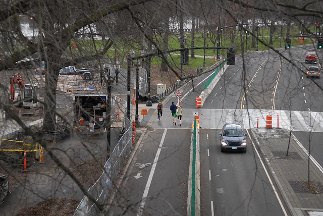
Re-allocating roadway space on Naito is a much-needed step for Portland. Waterfront Park is too crowded to be used as a transportation corridor and Naito Parkway’s existing bike lanes are outdated and inadequate. And it’s not just bike advocates who’ve been talking about this.
Hales has talked about it several times. In August 2014 during a bike tour with fellow dignitaries he told me the Naito Parkway idea “is a slam dunk” and that it’d be “a very compelling project” that could be done, “fairly quickly.” “What if we just took that east lane on Naito and went ahead and made it into a bikeway?” he wondered out loud, “You know we really don’t need all those lanes.” Then, during his brief romance with biking to work before he dropped out of the mayoral race, Hales said making “Better Naito” permanent was “The next thing on our list.”
Speaking of Better Naito, a politician couldn’t ask for a better way to float a bold idea before putting real funding behind it. After a highly successful partnership with volunteer urbanist group Better Block PDX last year, the City of Portland has doubled down by bringing back the temporary biking and walking lane to Naito for three months this year. The “tactical urbanism” demonstration is the largest and longest-lasting project of its kind ever deployed.
Advertisement

(Photo: J. Maus/BikePortland)
Redesigning Naito also makes sense from a planning and engineering standpoint. Its current configuration of two standard bike lanes and five auto lanes (including a parking lane) is an embarrassment for America’s most bike-friendly big city. When the Bureau of Transportation spent $10 million to repave Naito in 2007 the design was outdated and inadequate for cycling day it opened. Even PBOT’s longtime bicycle planning coordinator Roger Geller acknowledged (at a meeting of the Bicycle Advisory Committee in 2012) that, “By the time we implemented it [Naito paving project], we would have been ready for buffered bike lanes or cycle tracks.”
And going back in further, the City of Portland’s 2003 Waterfront Park Master Plan (link) called for several biking and walking improvements that have never materialized: a 10-15-foot path (“The Promenade”) that would wind through the park from the Hawthorne Bridge to NW Couch; and a new 6-8-foot wide sidewalk that would have run the full length of the park.
So far the technical details of this project still need to be ironed out. The Oregonian reported this morning that, “The proposed funding would provide for a permanent barrier in a configuration similar to the pilot program [Better Block], but the design is still in early stages.”
Perhaps as a starting point we could look at the design of one of London’s cycling superhighways we highlighted last year. And of course anything major improvement to bike access on Naito would have to include a fix for the notorious “Naito Gap” where the bike lane ends under the Steel Bridge. If we can fix that gap, we’d be tantalizingly close to connecting to the thousands of new residential and commercial units being built further north and the vast biking potential of the industrial area.
Imagine a safe and efficient bikeway from the Hawthorne Bridge to NW 26th Avenue.
With less than a year to cement his transportation legacy, Hales has put forward his most interesting bike project yet. If this proposal makes it through the budget process (not a foregone conclusion by any stretch) it would be the very first protected bike lane to be built during his tenure. And it’s far from a “slam dunk” unfortunately. Hales hasn’t made transportation projects a priority and his last budget is clearly focused on other pressing needs like affordable housing, homelessness, and police staffing. But at least we’ve got something on the table. We’re eager to see what happens next.
— Jonathan Maus, (503) 706-8804 – jonathan@bikeportland.org
Our work is supported by subscribers. Please become one today.



Thanks for reading.
BikePortland has served this community with independent community journalism since 2005. We rely on subscriptions from readers like you to survive. Your financial support is vital in keeping this valuable resource alive and well.
Please subscribe today to strengthen and expand our work.
WOW!…I will have to read more after work. Way to Go Mayor Hales (and Better Block)!
The London photo is closer to a $3M-$5M project. Better Naito needs several signals modified as well as those center islands that need to be trimmed back for large trucks to be able to make the turns onto northbound Naito.
The usual suspects are having a field day with this in the comments of the Oregonian article.
(I changed the T word to “suspects” because my initial comment was flagged for moderator review.)
Thanks! I really dislike the word “trolls”.
naito parkway is not hard to use. the pavement itself kind of sucks but other than that its pretty bike friendly. the biggest obstacles are or were, the easternmost section from overton to the steel bridge where the pavement is terrible but it looks like they are in the process of repaving as we speak and obviously the gap over the tracks and below the bridge. there’s just a lot of other construction happening right now and the hobo gauntlet underneath the burnside bridge can sometimes be tricky. but the bike lane is fine. don’t mess with it. want to add a more friendly environment down there? increase police foot patrol in waterfront park so pedestrians and normal Portlanders can use their space again…that’s it.
This will be much appreciated when Biketown floods the waterfront with riders who will learn there is precious little space for safe cycling downtown.
It is partly paid for by eliminating the PBOT “Out of the Mud” program, much of which was for building narrow asphalt roadways on existing gravel streets, such as on the HOP in East Portland, the 100s greenway, and various SW bike projects. Cut a million from bikes to pay for bike lanes on Naito. Not a particularly good bargain.
IIRC, there was a survey that went out to people in East Portland, and contrary to popular belief, paving unimproved roads was not a high priority. Sidewalks were #1 on the list. I tend to agree with this: paving gravel roads only helps people driving and makes those streets less friendly to people walking because drivers then drive faster on them.
You are correct. I helped with that survey. Given a bevy of other needs, paving gravel streets was a relatively low priority in East Portland; but so was any sort of bike improvements as well, alas. Sidewalks, crossings, and transit were much higher priorities. However, it will be 2070 before East Portland has sidewalks at the level of inner Portland, given Hales’ priorities.
I agree that Naito is a good project, as are most of the housing ones, but the $11 million for police could be better spent on sidewalks for East and SW Portland, not to mention TDM diverters city wide.
I agree, the gravel roads are a bit of a red herring. They are much safer than the dangerous arterials, so we should be fixing those instead. At most, a gravel road is annoying, while people are getting killed on the over-engineered stroads.
In my opinion, direct “safety” is not the biggest local benefit of transportation improvements – better health from physical activity and better air quality is. In that context, the ease and dignity benefit for walking and biking that comes from paving and/or adding sidewalks to a few important gravel connections is worth the money. e.g. 87th to the Springwater.
How much of the improvements you see from paving 87th could be had by instead paving the cow path from SE Henderson to Springwater? How much would that smaller project save vs paving 87th? Enough to put in continuous sidewalks on SE Flavel from 82nd to 92nd?
I live near a number of unimproved roads, and would hate to see them paved. I get enough North/South cut through traffic on my street between Powell and Division. Paving these roads would only make the problem worse if better car access from 82nd was available.
And I’m glad ODOT is currently improving 82nd, but there is part of me that hopes SE Mill east of 82nd remains pretty much as is, it’s one of my favorite parts of the entire Greenway system. Even though I know it desperately needs sidewalks, removing the trees to do so will completely kill the couple blocks of the countryside feel to it. But don’t think I’m getting all NIMBY, cut em down and build the sidewalk. I know it needs to happen, there is so much school foot, bicycle, and car traffic since it is a thoroughfare for Bridger, Harrison Park, and even the Creative Science School. But I admit I’ll miss the narrow street and tall trees.
But I regress, sometimes the best infrastructure is no infrastructure.
The “Out of the Mud” program had a 18-foot model street more-or-less based upon the very street section you are writing about, on Mill between 82nd and 87th, with the beautiful tree canopy.
I agree that unimproved streets with giant puddles are an effective way to keep speeds down, but am I right in my assumption that you can’t build sidewalks without paving the street?
It seems like I read that somewhere.
It depends. As long as there is a grass strip between the sidewalk and street, then there is no need to pave the street. For example, there are sidewalks along a few gravel streets in the Woodstock area, built 50 years ago. There are also sidewalks along part of Yamhill in Gresham (between 90th & 97th) where the asphalt street has no gutter. Such streets are common in the Wedgewood neighborhood of northern Seattle, for example. One can easily imagine that the PBOT-neglected and crumbling streets of inner Portland eventually returning to gravel, while the existing sidewalks are maintained by homeowners.
However, if a street has a sidewalk flush with a concrete gutter, you might as well build the rest of the street, as the sewers and gutter are the most expensive part of any street. Similarly, if a street is built with asphalt, the best way to prevent cracking at the edge is to lay a concrete gutter and sewers. If you are going to pay for that, you might as well pay a bit extra and have a concrete sidewalk poured in at the same time.
David,
Out of the mud doesn’t build anything, at least, hasn’t built anything. It was basically an appeal process for developers to see if they could get by on a lower standard of improvement than the 50’s era half street (a standard we can’t afford to maintain anymore). Reviews of requests have devolved into e-mail voting.
That’s too bad. It seems like $1Mil/yr. could fund at least a block or two a year of connections with city-wide or at least neighborhood-wide significance getting paved and/or sidewalked largely at City expense. An adjoining property owner contribution is appropriate, but the fact is that most of the benefits would accrue to people other than the adjoining property owners, which is why most blocks haven’t opted for LIDs to date. I would think something like 90% City / 10% property owner would make sense.
One of the issues is that adding an improved street in a sea of unimproved area means it will start getting all the traffic. This issue was identified in Cully. The city has run several scenarios on funding mix/proportions. I was in favor of the City funding the design portion, with only construction costs financed by fronting property owners.
The “Out of the Mud” program was developed by PBOT for multiple purposes, including the ones you correctly outlined. However, one of the purposes was for PBOT itself to build cheap, “temporary” asphalt streets on existing gravel roads for the HOP (Holladay-Oregon-Pacific) greenway between Gateway and 132nd. There are existing gravel sections on Oregon at 110th-111th and on Holladay at 120th that the PBOT was (is?) reluctant to rebuild as full “complete” streets at a cost of $5 million/mile, when they could pay less than $500,000/mile with a substandard street. They were also considering it for parts of the 150s greenway (for example, 157th from Couch to Glisan).
I fully expect the next mayor to reinstate the program, or something very like it, especially if the gas tax fails.
Re: the first photo – you calls those bike lanes “outdated”? Wow, I’m jealous – you should see what we get to ride in!
Barbur to Naito has to be addressed. It would be nice to get on the “protected” area before you get killed….
I second this. The ride from Barbur Boulevard to Front Avenue requires guts, timing, and luck.
Great idea, but I want to see the details. Will he allow camping on it?
OK, this is neato to improve the bike lanes we finally got only a few years ago, but could we also do something to fix the long stretches of Naito that have no bike lanes at all? Obviously the “gap” is the absolute highest priority, but there’s still an awful lot of Naito where it’s freaking scary to ride.
My thoughts exactly. The southern section between where the ODOT section ends and the Hawthorne Bridge have ZERO infrastructure for biking (the sidewalk is not a bikeway). I fear we’ll end up with a stretch of Platinum Level Superhighway where there is already a bike lane, with an empty desert on either end.
The section to the north should be getting a buffered lane with the pending resurfacing, but the southern section is not being looked at.
They need to fix the south end FIRST. The bike lane on Naito is just fine. Getting to it is the problem…..
D,
Doesn’t that depend on which direction you’re approaching from?
I am talking about riding from south to north, which is the direction of most travel (and all travel on the east side that we are discussing).
The ride from the Barbur exit onto Naito is one of the worst stretches in the city. A lot of people have to take it if they use Barbur to commute.
It is ridiculous how dangerous it is really, I go over Terwilliger and through downtown to avoid it a lot of days.
I ride in the Naito bike lane about every day, it is easy, I have no idea why this particular stretch is getting so much attention. Kids, etc, can ride on the waterfront.
Commuters who use Barbur (and there are a lot) are completely ignored in all of this.
No it’s not. It’s too small and too close to heavy motor traffic. I won’t ride in it.
You have a 20 foot wide concrete MUP path about 50 yards away….
We can spend the money a dozen other ways where there are no options.
Naito and the waterfront are two.
I personally think the waterfront path is fine except when summer festivals take over the park and shoehorn everyone between the river and large chainlink fences.
Obsolete when it opened — I think that describes everything Portland has built in the past decade. If only we had some way to travel into the future and see what a bikeway should look like. Try this: put a colander on your head and look at our 2030 mode-share goals with 25% of trips by bike and significant transit + walking. See a street with one bike per car on it. (Sometimes two cars but the second is often a carpool.) Families in box bikes/trikes, grannies, and hurried commuters are sharing the bike lane — how wide is it? What happens when everyone in the bike lane has to stop? How wide and how many car lanes do we need for those 1 or 2 cars? A third of the trips, so a third of the space?
Now, we have maybe a dozen years to build that. everywhere. as a connected network. Are we going to build it all twice because we poured concrete like it’s 1999 for the first one every time? Remember Not Everybody Can Ride a Bike All the Time. Also: “Freight!”
Oh, say a positive thing… Slowclap.gif for the easy overdue budget line item showpiece with obvious sauce.
Ok, this is great and all if we were doing it everywhere, but we’re not. We’ve invested a TON of money in making downtown Portland super nice (though, not for biking) and now Hales wants to spend more? Is that how we want our city to work, make the tourist areas great before we make other areas even OK?
There would be very low-budget ways to improve Naito in the short term that would leave at least $1mil for other priorities. Like, don’t move any curbs, just stripe a walking lane and a biking lane with planters between the lanes. And change the signal timing so people can walk across it without waiting for an eternity. It feels kind of crazy to be spending a good chunk of change on Naito when outer Foster doesn’t have sidewalks on either side of the road (and isn’t planned to in the near future), when people continue to die on outer Division on a regular basis, and lots of roads in the West Hills are still utter embarrassments too.
It’s not just tourists – lots of regular Portlanders live and work and recreate in Downtown. When ODOT is spending $139 million on Phase I of the Sunrise Corridor I think your anger at the possibility of the first (the first!) physically protected bike lane in Downtown is misplaced.
I’ve used outer Foster and Naito a lot. It’s difficult for me to “choose” Foster over Naito, since the potential effect is so much greater given change in the latter. Mac’s point is well taken. It’s unfortunate we have to make these sacrifices. Plenty of funds exist. They’re just used for primarily irrelevant and antiquated ideas. Alex has a good rule of thumb for projects in general. But Naito deserves this. It exemplifies the process from temporary demo to fully protected lane. Our first protected bike lane downtown. Finally.
That’s true… they have us where they want us, fighting over scraps. How do we gain enough political power to disrupt the road-widening/industrial complex?
Alex,
What do you think about sharrows at the start of every block, in every lane, downtown, including the streets with bike lanes already?
I don’t hate that idea, but implementing some protected bike lanes in the already-funded downtown bike infrastructure project seems like a more 8-80 solution.
Agreed.
Another nuance recently brought up at a design seminar is that protected bikeways in CBD’s need to be 8 feet wide so that through riders can go around local visitors. Cycle tracks in busy commercial locations may not be the best place for through cyclist to ride (Hawthorne, Belmont, Lloyd, Fremont), and the parallel greenways may be the better option for the non-local trips.
Downtown is not just for tourists. People who live throughout the metro region go downtown too. For recreation, shopping, work, etc. I work downtown, as do many others. I used to live right next to downtown too and would frequently walk there. The city actually wants to build good bike infra in a heavily-bike-trafficked area; we should not be opposing this because of an outdated notion that “downtown is for tourists”.
I work downtown too. I know lots of people do. But, I really do think that tourism and the concentration of politicians and politically powerful, high-wage workers downtown leads to a greater share of the city’s investments going there than is morally right. If we had a higher overall transportation funding level and we’re working quickly to make everywhere else good, I’d say, heck yeah! Keep making downtown great! But we don’t. Not yet, at least (vote “yes” on the gas tax to get us 15% of the way there!)
“a greater share of the city’s investments going there than is morally right”
What do you think the right share would be, from a moral perspective? Nothing? Here is a slide showing the City’s planned distribution of transportation investments for the next 20 years, compared to number of users:
http://imgur.com/kBB05Fj
The Central City is one of the areas of the city where the share of investments proposed is lower than the share of users. (The Better Naito Walkway / Bikeway is one of the investments included in that planned spending.) If we’re going to meet our climate goals, bicycle mode split goals and vision zero goals then there does needs to spending on infrastructure in the Central City.
As we’ve seen again and again in Portland, there are “plans” and then there is what actually gets allocated in budgets and completed. If we keep taking planned money from East Portland and Southwest Portland to spend in the Central City, then our actual spending will look like it has for the last X decades (which is close to the reverse of what is shown in that slide).
I must have missed all that money that’s been spent on building out a network of bike infastructure in the Central City.
Not bike infrastructure, but there have been millions upon millions in transit. I’m not saying any of this is “bad” – I agree that both great transit and a great bike infrastructure network is needed in the Central City – but funding it by removing funding from East Portland and Southwest Portland is not the way to go. It needs to be new money.
Do you have evidence that Central City transit projects have been funded by “removing funding from East Portland and Southwest Portland”?
I wasn’t trying to say that about that past (although, the fact is that a ton has been spent in the Central City over the past few decades and not so much in outer areas), but this budget includes an addition of $1.5M for SW Naito, a removal of $1M for “Out Of The Mud” which is almost entirely for East and Southwest Portland, and no transportation additions that I can discern for East or Southwest Portland.
The city has also poured millions into Lents, trying to create a new town center with nice sidewalks, businesses, and now, affordable housing. The Foster Streetscape project is another high-profile investment for an underfunded area. Improvements are slated for 122nd. The Green Line runs along East Portland, too, as does the I-205 path. Powell-Division is meant to serve East Portland and Gresham.
There are plenty of examples of high-profile investments for underfunded areas. On the other hand, why shouldn’t the city invest more into the densest part of town? There are tons of jobs downtown, high wage and low wage. Why shouldn’t we invest in transportation for people to get to those jobs, from wherever they live? Ideally, we’d have more job centers than just downtown, and the city is working on this (much of Foster is zoned Mixed Employment in the comp plan), but downtown still serves as our best chance for car-free transportation, and it would take a lot less investment to get there.
The most expensive parts of the MAX system are outside of the downtown core, so transit capital expenditures are pretty well spread out. You have a point when you look at the streetcar costs, though.
East Portland already has over $60 million in transportation projects already lined up, with another $40 million being requested through various grants with the Feds, not including the possible BRT project on Division. The problem in East Portland is not a lack of funding.
The real problem is getting PBOT off their lazy butts and actually build stuff that is already paid for, on time, and within the prescribed budgets.
Paid-for East Portland projects include:
Outer Powell cycle-track, 119th to 136th (and maybe up to 162nd), plus sidewalks.
130s greenway, Springwater to I-84
100s greenway, Main to I-84
150s greenway, Powell to Halsey
122nd buffered/protected bike lanes, Foster to Airport Way
Division infill sidewalks and buffered bike lane, I-205 to 148th
4M greenway – Market, Mill, Millmain, & Main – 92nd to 176th
I’d love to chat more, but I’m off to testify at our local city council for more bike infrastructure this afternoon – something y’all should considerin’ doin’ in your neck o’the woods!
Ok, I don’t have all the facts to argue about X amount of money. I do know that the conditions in East Portland are just bad. There are a ton of busy streets with no sidewalks – Foster, 112th, and Holgate come to mind in southern East Portland. Comfortable, safe pedestrian crossings are few and far in between. There is I think *one* greenway east of 205 and a number of bad bike lanes, and the I-205 and Springwater paths, and that’s it for bike infrastructure (and your average side street doesn’t go through).
I don’t understand how anyone can think that we haven’t underinvested in East Portland relative to the central city over the past three decades given the facts on the ground.
And it’s not like we’ve disinvested everywhere since annexation in the ’80s – we’ve built two new streetcar lines, a tram, a fancy transit mall, and three MAX lines through downtown just in the past 15 years. East Portland got… A MAX line built on the cheap in a prebuilt 80s “transit way” on the side of a freeway that almost completely kills the potential for transit-oriented development.
Good to be reminded by David that a significant amount of funding has finally been allocated. Having not heard anything about 122nd lately, I’d begun to fear that the money had been taken away.
Alex— I’m not denying that East Portland has huge needs. I’m also not arguing against investment there. You can read through every comment I’ve ever made on this site, and you’re not going to find a single one where I suggest we shouldn’t be building sidewalks in East Portland. The current Financial Year 2015/16 budget has PBOT spending $91 per user on capital projects in East Portland and $40 per user in the Central City…. and I’m fine with that. (As an aside, PBOT is spending $136 per user in the Southeast Uplift Area).
But I do get extremely annoyed that every single post on BikePortland about a Central City project has to have a “but what about East Portland” comment on it. I can’t remember ever reading that comment on any of the posts about the 20s Bikeway Project or the Sellwood Bridge, which are the two main reasons PBOT is spending the largest amount of money in Southeast this year.
The Central City has real needs, that need to be addressed. We’ve barely started the process of building out a genuinely useful (let alone world class) bikeway network in Downtown. Any equity strategy that says “let’s not ever invest anything in Downtown Portland again” is very dumb equity strategy indeed.
We are all chasing crumbs – there is simply not enough to go around. Raise the gas tax, then raise it again. Grow the pie. Build the 2030 Bike Plan.
>I don’t understand how anyone can think that we haven’t underinvested in East Portland relative to the central city over the past three decades given the facts on the ground
Shouldn’t you consider the baseline infrastructure levels at annexation? And if investments are spread over 6(?) times as much area, would you expect the same facilities to be built?
>disinvested
Are conditions in East Portland really worse than before annexation?
Most of Lents was annexed in 1913, over a century ago; parts of Pleasant Valley were annexed in the 1960s, especially around Powell Butte; the vast majority of East Portland (and Cully, Sumter, Brentwood-Darlington, & easternmost Montevilla) were annexed between 1986 and 1991; the last slivers were annexed in 1992, supposedly to build storm sewers, but more to add to the property tax base of Portland, to pay for downtown projects. Portland more-or-less suddenly stopped annexing after the property tax roll-back in 1992, when it no longer paid to annex.
For the area annexed after 1986, nearly all the streets (and all the bike lanes and multi-use paths, for that matter) were built by the county before annexation. The blue MAX was from 1986, during annexation. The main exceptions are 102nd, which was rebuilt by the city, & Cherry Blossom. I-205 was completed in 1990 by ODOT.
In the ’90s, yes, the baseline infrastructure levels were a reasonable argument. But it’s been 25 or 30 years since annexation. The City has had time to redo the worst roads of East Portland. It has not done so, so far. Allocated funding percentages moving forward are much better (which played into my choice to move to East Portland) but East Portland residents are rightfully skeptical that the City will follow through on its promises without continued pressure. Hence, skepticism over any movement of money from East Portland to areas closer in.
The issue is that population has increased significantly to the point that East Portland is almost (not quite, but almost) as dense as inner eastside Portland, yet the infrastructure has not been improved to match. On a per capita basis, it’s disinvestment (more traffic, same facilities that aren’t appropriate for those traffic levels).
FYI: The chart is “per household” not “per person”. On average, East Portland has households twice the size of Central City (1.43 people/household in Pearl vs 3.10 in Powellhurst-Gilbert). The per-person distribution shows Central City getting much more than any other district, followed by NW, then East Portland & Central Northeast; Southeast Uplift and North Portland get the least.
However, your ensuing back-and-forth argument is a bit pointless, as the TSP is a projection of 20-30 years into the future. The actual distribution of resources is purely a political question, from Council, PBOT, Metro, ODOT, the Feds, and the success of community activists such as yourselves.
” chart is “per household” not “per person”.”
No, it’s not. It’s “per user”, which is a combination of people who live there and who work there.
Read it again.
I did. I also listened to the whole work session, back in November. Here’s the slide showing projected share of investment per user (singular) by coalition:
http://imgur.com/9gQPa6Y
The Central City gets $901 per user over 20 years. East Portland Neighborhood Office gets $1,761 per user.
Is it really per user (person or job)? If so, why does it say “households+jobs” instead of “people+jobs”?
Thank you. You’ve explained it better than I could.
I’m really not sure why they used the word “household”, but every single time I’ve seen the city use the word “user” in the context of spending decisions it means residents + jobs. Here is an explanation from the City Budget office:
“The eight areas used to describe the City vary significantly in size, number of residents, and many other characteristics. In order to increase comparability between the areas, spending has been described in terms of spending per ‘user’ (residents + employees).”
http://www.portlandoregon.gov/cbo/article/569325
It’s otherwise called “fudging” the numbers, an attempt by bureaucrats to compare apple to oranges, like comparing bike commuters to recreational riders.
Alex,
The $1.4M is mostly signals and signal contingency. the capital work for the lane is about $0.5M.
Oh – OK. Phew, that seems a little more reasonable way to spend the money than street reconstruction. What’s included in the signal work? Is it mostly to add bike-specific signals on Naito southbound in order to avoid conflict with turning motor vehicles?
mostly.
A funding commitment by Hales can pretty easily be undone by the next Mayor. Depending upon the vote in May, his budget may be null-and-void by June. It’s happened before.
On my ride Sunday I learned that there IS a protected intersection in the Metro region: River Road where it turns right onto Glen Echo in Oregon City. I’m actually not a big advocate of separated infrastructure, but that right turn with the big physical buffer was amazing! Jersey barriers on Naito would be a game changer.