Two months ago, we made an unfortunate error: We ran a post observing that the new Tilikum Crossing was simultaneously boosting bike traffic and reducing bike congestion on the Hawthorne Bridge sidewalks.
Trouble was, the source of our data — the Hawthorne Bridge’s automated bike counter — had been malfunctioning, so the findings were bogus.
Now the better data has arrived … and it shows pretty much the same thing that the fake data had seemed to.
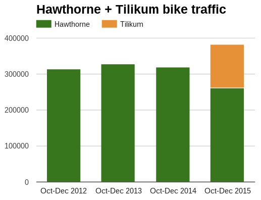
Combined bike traffic over the Hawthorne and Tilikum bridges since Oct. 1 is 20 percent higher than bike traffic over the Hawthorne in 2014.
And thanks to people shifting their trips to Tilikum, bike counts on the Hawthorne are down 18 percent this fall. That’s a welcome change on a bridge where crowding often worsens tension among people biking, skating and walking.
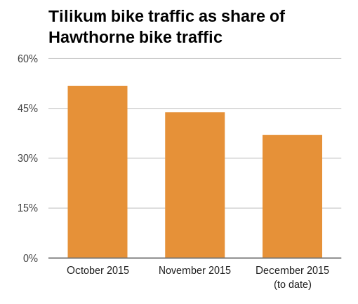
However, the first few full months of Tilikum data also show another trend worth watching: during the rainy season, Tilikum bike traffic has been falling much faster than Hawthorne traffic.
What’s going on here?
It could be that Tilikum users are disproportionately likely to switch to a different mode or skip a nonessential bike trip in nasty weather. If that’s the case, we’d expect this ratio to climb back up next summer.
It could be that people are souring on Tilikum for some reason and switching back to Hawthorne. If that’s the case, we might expect this ratio to keep gradually leveling off.
Advertisement
It could be that Tilikum was still seeing a surge of “curiosity rides” in October. If that’s the case, future ratios will probably keep hovering around 40 percent.
Whatever the case, this is clearly a sign of something that ought to be obvious: just like new auto lanes, useful new bike infrastructure attracts users.
In engineering jargon, bike infrastructure induces demand.
Back in 1999, skeptics of the Hawthorne Bridge’s sidewalk improvement argued that wider sidewalks were a costly boondoggle — more space for biking than the bridge would ever need.
Over the 10 years that followed, bike traffic across the bridge tripled.
All of which means it’s especially important for us to keep looking for ways to improve the connections to Tilikum. If we can learn anything from its northern neighbor, it’s that if you build it and people come, more people will be on the way soon.
— Michael Andersen, (503) 333-7824 – michael@bikeportland.org



Thanks for reading.
BikePortland has served this community with independent community journalism since 2005. We rely on subscriptions from readers like you to survive. Your financial support is vital in keeping this valuable resource alive and well.
Please subscribe today to strengthen and expand our work.
It is going to be difficult to get good longitudinal data as the opening of the new Sellwood in Feb is also going to change things. Do we care if the rides are commuter or recreational? We may need to do some intercept destination survey data in late 2016 to see.
I know my looping patterns downtown have changed significantly recreationally, but only minimally for commuting……I use every one but the Burnside.
I wonder if they are putting a bike counter on the new Sellwood bridge.
I’d be very surprised if there wasn’t!
I’m still having trouble thinking that a lot of people will use the new Sellwood to commute towards downtown. It’s a pretty rough way to get downtown, esp. when compared to the Springwater to Tillikum or Hawthorne.
You don’t really have much choice in the matter if you live SW-ish of the Sellwood bridge, the only other crossing to the South is in 9 miles away in Oregon city. On top of that, the Riverview cemetery which has long been the de facto route for lack of a bike lane on any nearby arteries, dumps you out right at the Sellwood. So, don’t worry, plenty of people use the Sellwood now and will continue to use the new one.
So you think people in SW Portland and West Linn are biking east across the Sellwood to get to the Springwater, and then back across another bridge downtown?
Or did you mean people that are SE of the Sellwood Bridge?
And I agree that people use the bridge (I am one). But my experience is that it has mostly been recreation riders, L&C students, and a few families from Sellwood. I guess if your destination wasn’t downtown, but somewhere in the S-SW, the Sellwood makes sense. I just dont’ see it as a viable route for downtown commuters.
i for one actually use this route to go SoWa (OHSU) and i live in Sellwood. I like this route because it connects directly to the Tram rather than the Springwater Corridor: dealing with the odd path to get on the right side of Tilikum Bridge then bike south to get to the tram.
safer or convenience? in this case, convenience wins.
Actually, yes! That’s exactly what I do. I take the cemetery to the Sellwood, and then cross the Hawthorne (and now the Tillikum about half the time just for the views). It’s faster than using the network of trails on the West side of the river. Actually, our office just moved to the East side so now I don’t even have to cross over, and it’s going to be a breeze with the new Sellwood.
Like you said though it does see a higher-than-average proportion of recreational riders because everyone on the East side can just take the Springwater and once you get into LO, West Linn, Tigard, etc, biking to downtown is quite an endeavor. Still though, I’m confident the new bridge will see plenty of bike traffic.
One of the things that irritates me about the Tilikum Crossing is the traffic signals where it crosses SW Moody St. These signals can take several minutes to change, even when there is no opposing traffic. My guess is that some cyclists are sufficiently annoyed by this to change back to the Hawthorne.
Actually, I notice irritating traffic signals mostly on Saturday and Sunday mornings between 6 a.m. and 8 a.m., when I take a recreational cycle. Frequently, traffic signals along N Vancouver and N Williams will cycle when there is no traffic, and I catch the red about 50% of the time (as one would expect). I’ve also experienced an issue at N Rosa Parks and N Interstate when it will skip a green because there is no detector for bikes. If PDOT/ODOT want to encourage biking, they need to think about how traffic signals work, even when there are no cars around.
Imagine a world in which pedestrian advocates succeed in getting all crossing buttons replaced with continually cycling walk signals at deserted intersections.
it would be awesome… the speeding cars would be tamed and peds wouldn’t have to beg to cross…
You beat me to it. In a pedestrian-oriented area, lights should be pre-timed. It’s worth the small amount of delay to bicyclists and drivers.
All the signals on SW Moody should default to red (traffic) lights. Car drivers should expect to hit a red light at every intersection.
There is way more transit/foot/bike traffic on Moody than auto traffic, nearly always and in most weather. In the summer months it’s funny (but not funny haha) to see twenty people on feet/bike waiting patiently at the Gibbs/tram ped crossing for one or two cars to crawl through their unquestioned green light.
I’ll start dreaming about that right after I hear about the big Air Force bake sale…
“…all crossing buttons replaced with continually cycling walk signals at deserted intersections.” oliver
The technology for that type signaling may be available…the money to have such signals installed and maintained on city streets, may not be available for awhile, at least.
I just use the sidewalk when I’m heading to the CHH off the Tilikum bridge.
There is a lot of transit infrastructure that also goes over the Tillikum bridge – so maybe it is easier for folks on this route to switch in bad weather. I’m sure its not the whole factor but could be a factor
I’d agree, for many south of the Tilikum the MAX option would likely be an alternate in rainy/cold weather. Would be interesting to see if there is a jump in MAX ridership that compensates the drop in Tilikum bicycle traffic – though it’d be hard to prove one way or the other.
A BES sewer wetlands project by the Sringwater Corridor near Oaks Park will close that trail and it will shift bike and pedestrian traffic to both SE surface streets along with the multi-use trail on westside of the river to historic levels once the Sellwood bridge opens in late winter.
Historic levels on the westside MUP will quickly result in dead terriers and/or stabbed bikers. We need a bikeway along macadam.
Just think how amazing it would be with flyovers on each end that avoided signals, multiple turns…etc. There is also the added bonus that anything you do on the bridge is filmed and archived forever. How incredible would it be if every major intersection in Portland were filmed and archived forever…and drivers knew that?
Just curious.
you want a video documented police state here?
If it means people act appropriately when operating heavy machinery in public. Honestly freedom and privacy are overrated in a society of people who can barely tolerate each other and treat each other as disposable and meaningless.
The primary effect would be to catch the roadraged motorist that targets the cyclist. I would not mind it but I enjoy picking them up out of the masses and while they are chasing me I can sometimes direct them into other oblivious texting drivers.
Well…kind of, yes. Slippery slope, I know, but I’m all for police wearing body cameras because I think it will cut down on misbehavior. Seems intersection cameras would have the same effect.
If cameras in public are the true definition of a police state, I don’t agree. We are already in a society where every electronic action we take online is recorded forever. Who we call is recorded forever…etc. Why would cameras or speed cameras be a problem when we are out in public?
We already have that on the bridge..as the Oregonian proved so well. Yes, a camera is a low cost device to alter bad behavior. You can film me driving anytime.
We were forced into that, against our will. Many of us still take efforts to negate at least a portion of this tracking – usually out of sheer principle.
That a majority gave away their rights willingly is not justification for stepping it up.
We understand the police and the DA are unwilling or unable to hold a driver accountable for their actions. The unspoken (or spoken) rule is “take it to civil court”. That requires evidence and often..video evidence is what is needed. So yes…video busy intersections and make it available to the public. Heck..stream it onto the internet.
yes please! cameras on every corner watching everybody…
I live in SW a little past Multnomah Village and find that riding into inner SE utilizing the Tilikum makes sense. Using the Tilikum for my route home is not conducive. The route up to Terwilliger is terrible and I don’t like riding Barbur southbound. I either take the Hawthorne or I take the path down to the Sellwood. Once the Sellwood bridge is open, I’m certain that will be my preferred route going home.
Multnomah Village is the only destination in my normal monthly routine where the commute HAS switched for me. I used to take Hawthorne-Tewilliger-Capital now I take Tilikum-Corbet-Barbur-Multomah.
Imagine how people would use it if it went anywhere…….
Use what?
like the biggest employer in the entire city?
Just because you don’t find it useful, doesn’t mean it’s useless.
I mentioned the word “beg button” to my local engineer. He honestly didn’t know what I was talking about. He had some other long fancy word for it. Beg button is exactly what it is. A ped or a bike begging to cross and begging not to get run down by a car.
“…Beg button is exactly what it is. ..” mark
Sorry…but that negatively contrived term is not what pedestrian crosswalk signal buttons are. Actually, pedestrian crosswalk signal buttons are traffic control devices. Literally, just one person wishing to use a crosswalk to cross a busy street, can stop dozens of people driving motor vehicles in the street, to stop so people can cross reasonably safely in the crosswalks.
Of course, the city’s traffic engineers likely have options that would enable people using pedestrian crosswalk signal buttons, to have more extensive control over the stop of go of vehicle traffic. This is something engineers likely are routinely considering. What adjustments can reasonably work for traffic needs that must be met, are probably among deciding factors.
How many bef buttons actually stop all traffic? You might be surprised how many do not. Basically it’s usually a device that makes Peds feel safe even when other traffic is moving.
yet they’re not called “beg sensors” in the street for cars and bikes?
If pedestrians had the same “rights in practice” as vehicular traffic it would cease to make any sense to call them “beg buttons”. Instead, we have the current situation where every pedestrian entering the roadway at a corner has a crosswalk with abysmal compliance by vehicles. It takes flashing beacons and paint in the road to give peds the ability to safely cross while there has been literally zero change in their ROW status.
From the pedestrian legal perspective, every time an intersection becomes signalized they have actually lost ROW…or maybe a better way to say it is “their ROW has become conditional”.
The whole dynamic is silly. The only way to get motorists/cyclists to stop for pedestrians results in pedestrians ceding the ROW they had all along.
I’m impressed by the combined uptick, especially when factoring the weather. Last year, I didn’t even put fenders on my bike!
One reason for the foul weather popularity of the Hawthorn bridge is the heat generated by the motor traffic. It must be 3-5 degrees warmer than the open and breezy Tillicum.
Tilikum Crossing is a lot like the old 5xxx+ series Trek: after the honeymoon, you really start to notice where they cut corners.
Fixing those connections won’t be nearly as easy as popping out junky Cane Creek S-2 headsets and installing a Chris King.
There are two ways to look at this:
(1) While the new bridge is relatively close to downtown it is not close to the highest of the city’s density and thus the majority of origins and destinations. A travel path closer to the center of a city will see more traffic than one further out no matter the number of lanes or quality.
If you have a thousand points of origin and destinations distributed matching a city’s real density the travel path intersections will actually reinforce and exceed the physical density. (*)
(2) People who use a bridge further from downtown are also those more likely to have a longer daily bike ride.
Of the whole set of seasonal bicycle commuters (those that defer when weather is inconvenient) it is reasonable to assume that those with the longest rides are also those most likely to stop riding during the winter.
Therefore the further away from downtown a bridge is the more proportion of seasonal riders it will carry and the more cyclical its bicycle counts will be.
(*) I have this sneaking suspicion it is a ^2 or ^3 power rule. This would seem to explain why traffic is always so much more unreasonable that common sense tells us it should be.
Away from Downtown, the city gradually is acquiring greater population density. The Tillikum is well situated to help meet travel needs arising from that increasing population growth.
Of course it is.
At the same time however density downtown will continue to increase against all common sense.
From a pure economic utility of public services standpoint downtown still has more to offer than the areas at each end of the Tillikum Bridge.
Trying to guide commercial development with infrastructure spending is like buying cat toys; they’ll play with the box it came in to spite you.
I ride past the Tillicum twice daily during the work week. Past, not over! My general perception is it’s too inconvenient to get on/off the darn thing compared to my older but tried-and-true route. And also, once you finally get on the Tillicum it’s a bit of a grind getting up and over the beast… It all adds up along the way so I avoid it.
And on the “grind getting up and over the beast”, I’ve been perplexed by the number of slower cyclists who insist on riding on the far left (inside) of the lane, rather than the right side of the bike lane. Shouldn’t the norm be for slower traffic to move right and faster traffic always pass on the left?
If they are slow..probably inexperienced. I bought a $5.99 bell from Amazon. It works wonders to move people over.
Well, in theory, you would ride on the far right to allow for passing on the left. But, speaking from experience, there doesn’t seem to be enough room to allow for a comfortable pass by hugging to the far right. It seems a lot easier on everyone involved to be taking the far left with my baby-loaded Fred sled and letting anyone with the stamina to pass have sufficient room on the right.
It’s sad that we blew our big bridge-building opportunity on a design / placement that only makes sense for OHSU employees. How many times will we build the infrastructure they’ve demand while treating everyone else’s needs as secondary?
It’s primarily a rail/bus bridge and there are ~5 new buildings in construction or in planning nearby. Like it or not the south waterfront is becoming a real neighborhood.
and with plenty of parking.
To be fair…this was trimets bridge. We now see how they would treat other users in their fantasy world.
This totally makes sense- – If offered an alternative to the Hawthorne bridge, where one misstep could land you into traffic and grave injury, the Tilikum is a great, safer (albeit kinda awkward) option, especially for OHSU and PSU employees/students, and South waterfront folks. It’s also a great option for new/rookie bike commuters, which is key in bringing in the “interested but concerned” demographic to cycling on a more regular basis..
That’s a very good point. For a more cautious cyclist, the Tilikum is a far better option than the Hawthorne bridge.
I’ve certainly noticed (not counting) way more people bike-commuting this December than any December in past memory. Lots of people on bikes out there, even in bad weather. It used to be pretty lonely out there.
The Tilikum drop seems sensible to me because Portland State’s classes end at the beginning of December and OHSU’s taper off shortly thereafter. (Tilikum also has the alternative of dry, heated light rail and streetcar.)
9 blocks are slated for new buildings in South Waterfront. I think that will have the biggest impact on this bridge’s traffic.
Side note: Kudos for keeping a busy publishing run through the holidays!
I’ve walked over Tilikum a few times and it’s always frustratingly crowded. I told my wife I wish they’d made it wider to handle all the people walking and biking.
I’m curious about the 1999 arguments against sidewalks along Hawthorne bridge. How much money has been spent on that vs how many trips were displaced or what it would have cost in maintenance of auto lanes if those users were driving?
I’m surprised no one mentioned the slope of Tilikum as a deterrent to ridership. This could be true for those who are not strong riders, nor reading blogs like this, or otherwise average riders who could perhaps just as well take the Hawthorne B without a significantly detrimental impact on their commute time or leisurely ride time.