(Photos J. Maus/BikePortland)
Next week the City of Portland Parks & Recreation bureau will start a project that aims to solve serious safety issues at an intersection on the Springwater Corridor path. As we reported back in January, the parks bureau has said they’ve been “aware of some challenges” at the intersection and were considering changes.
Now they’ve moved forward and the changes are likely to be completed by the start of May.
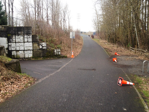
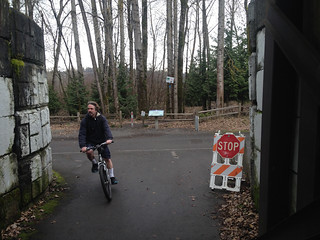
Where the Springwater path makes a “T” with the Oaks Bottom path (that connects to SE McLoughlin Blvd Milwaukie Ave.), PP&R will add a permanent stop sign, a series of pavement markings, and plastic “delineator” posts to sharpen the turning radius and encourage slower riding.
The changes come after a collision last spring when a woman riding west on the Oaks Bottom path rolled out onto the Springwater path, causing another rider to stop suddenly and fly over her handelbars. The woman who was riding on the Springwater suffered major injuries and had to be taken to the hospital by an ambulance.
This intersection is tricky because of bad sight lines on the Oaks Bottom path due to a tunnel just before it pops out onto the Springwater. Add in the downhill on the Springwater that leads to high bicycling speeds and you’ve got a recipe for disaster.
Here’s more about the project from a PP&R statement:
Portland Parks & Recreation is committed to taking special care in the planning and design of such paths to encourage a satisfactory experience and safe sharing of the facilities for the full spectrum of trail users, regardless of differing ages, speeds, interests, and abilities. The intersection of the Springwater Corridor and the Oaks Bottom Wildlife Refuge Trail poses potential challenges for the various users that converge on the intersection.
Advertisement
PP&R crews will be installing a number of signage and striping improvements to enhance user safety. The improvements include new painted traffic control striping, highly visible flexible safety delineators and signage including a stop sign from the Oaks Bottom spur trail (where people access the Springwater from city streets) onto the more highly-traveled Springwater Trail. The improvements intend to provide clear right-of-way assignment to trail users, to provide guidance for trail users to ensure full awareness of the intersection, and to minimize conflicts and clarify the intersection to separate conflicting movements.
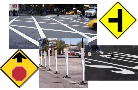
PP&R could not supply us with a detailed design drawing, but they did share stock photos of the type of signs, bollards, and pavement markings they plan to use…
The diagonal-grid crosswalk stripes will be painted on the Springwater to encourage downhill riders to use caution. The new stop sign and painted stop bar (on the pavement) will be placed on the Oaks Bottom path right where it enters the Springwater. The plastic delineator wands will force riders to make a slower, right-angle turn into — and out of — Oaks Bottom.
We’ll update this post tomorrow with the budget estimate for this project; but it will likely be less than the $10,000 roundabout solution we shared back in January.
The project is set to begin next Monday (April 27th) and last about a week.
UPDATE, 12:38pm: The cost of this project is approximately $3,200 and it was funded through the General Fund.



Thanks for reading.
BikePortland has served this community with independent community journalism since 2005. We rely on subscriptions from readers like you to survive. Your financial support is vital in keeping this valuable resource alive and well.
Please subscribe today to strengthen and expand our work.
I’m eager to see the actual plans. Diagonal cross-hatching is not a uniformly understood pavement marking that causes riders to slow down. Delineator posts placed on the pavement seem like they will simply create additional obstructions.
Has Parks & Recreation developed this on their own or have they sought advice from the specialists in the Bureau of Transportation?
I still think the solution I offered some months ago is better: widen and/or shift the path to the west toward the river. That would allow cyclists and pedestrians coming through the tunnel to have reasonable sight distance.
As someone who rides this area often, thanks for the update. Another, lower cost solution would be to open up the trails between the Springwater and river to decrease rider conflict. Those trails could be fun for commuters, people riding to trail networks, and children. This would extend the “singletrack” from the North that abruptly ends when the woods begin.
Honestly are people’s self-preservation skills so poor that they can’t slow down and look both ways before pulling out onto the path?
It would seem – based on a small sample size – that they are that poor. Northbound in the evening I’m amazed at the aggressiveness of the southbound Cat 6 commuters (HT to Bike Snob). Friday evening someone came screaming out from the underpass and came “this close” to causing a nasty pileup.
I doubt that lot reads this blog but still, a plea to slow it down a little . . .
I commute through that intersection just about daily (plus some bonus weekend trips!) and haven’t seen any incidents. The dangerous action is really from the user coming out from the trestle with out yielding, and fortunately folks seem to be quite cautious. I think this has to do with the connection point being an odd one, seemingly serving a pretty small set of neighborhoods and regular commuters. It is pretty apparent to anyone there for the 2nd time how to handle the intersection.
There really aren’t many noobies swinging down off the road there at all. Seems like slapping up a couple visual warnings will be a simple and cheap fix. Works for me!
Most people don’t drive very well, do you think they’d ride a bicycle any different?
if they’re a bad driver then I’d rather see them biking badly than continuing to drive badly…
Can’t argue with that.
Do we get stop signs at a discount? That’s the only reason I can figure we’d want to put one here. I can’t imagine the intent is for every single person on a bike to come to a full and complete stop. People surely need to use caution, but you don’t have to come to a full and complete stop to be safe. Over-using stop signs dilutes their meaning and teaches by example that you don’t really need to stop at them. Stop signs also don’t apply to people walking – it’s just not what they’re for. Why not use a yield sign here? Or something that says “Use Caution – Cross Traffic Does Not Stop”? Or…maybe we stop compromising designs to save money and install that already-pretty-cheap roundabout idea.
+1 on the roundabout.
The roundabout is not a feasible solution, nor would it simply cost $10k. Installing a roundabout would mean encroaching on Oaks Bottom land, which would instantly trigger an EIS, which is not cheap.
Not of you engineer the geometry small and tight enough that it performs the primary function of a roundabout: slowing users down.
An increasingly tightening series of serpentine curves going in
A VERY small diameter circular road
Narrow entrance and exit gates.
Lack of imagination ≠ impossibility.
Roughly 1/4 to 1/3 of reported bicycle injuries are from collisions with stationary objects. Riding down hills is also a major contributing factor to injury incidents as well.
Putting objects (roundabouts, pylons – what ever) in the middle of the convergence of two (3 if you count the springwater both north and south) downhill trails we might just end up swapping one type of incident with another.
And honestly, not sure which scenario I’d prefer.
and an unlit trail at that.
If the roundabout is small and tight enough to cause typical cyclists to slow down to the speed you seem to desire, that will preclude (or at least make it really difficult for) tandems, cargo bikes, and people with trailers from negotiating the roundabout safely. I’m certain I can manage it on my tandem even pulling a trailer, but beginners or intermediate riders on those conveyances won’t manage.
The solution is to increase sight distance by shifting the path a little to the west toward the river.
Can you elaborate on this? I’m familiar with federal NEPA law, which, if this were a federal action, would definitely not require an EIS. As I understand it, the Oaks Bottom wildlife refuge is city land. What are the EIS requirements there? I’m not even sure where to look for the (state or local?) rules.
It may depend on whether federal funding were involved in the acquisition or in construction of the Springwater Path.
Roundabouts are great for some situations. It would be overkill here.
Just to play devil’s advocate for a moment: perhaps someday the law will be corrected to make stop signs work as a yield for people on bikes. In that case, stop signs might make sense.
Can hardly wait for the Ladd’s style stop sign sting here. 😉
Have you ridden this path?
You pretty much do have to stop coming through that tunnel out to the springwater. The sign lines are terrible in both directions (again you’re passing through a tunnel).
I think you might be confused about the new set up. They’re only putting in one stop sign. Traffic on the spring water will not have to stop.
I have no issue with slowing down a little the minority of users at this intersection (spring water is by far the busier path).
Traffic devices don’t have to be different just because they’re used for bikes.
Thank you, davemess! I was frustratedly reading down that little string of comments and thinking this very thing. I always come to a full stop under that trestle (westbound to the T)–you really have to, and it’s no big imposition. Visibility is poor and not conducive to a yield-and-go situation at all! In fact, I’d wager it’s people who think they can glance, roll and go under that trestle that cause the most trouble in this spot. When I’m on the north/south section there heading into the dip I always ring the hell out of my bell and yell, loudly, “COMING THROUGH!”
no, actually, a stop sign will still mean you have to stop, no matter how many of them there are out there.
Wow, what a waste. I hope the plastic wands are knocked over as fast as they are when they install them in car lanes.
By the way, no part of the Springwater or Oaks Bottom path connects with SE McLoughlin Blvd.
“By the way, no part of the Springwater or Oaks Bottom path connects with SE McLoughlin Blvd.”
I intersects between SE Clatsop and SE Moores…
https://www.google.com/maps/@45.4606443,-122.6404721,16z/data=!5m1!1e3
Nope. That’s a bridge over SE McLoughlin.
Every problem can be solved with more signs. /s
Again with the installation of vehicle control signage on a multi use path where it doesn’t mean anything. Why are they doing this?
Correct me if I’m wrong, but is this not a place where bicyclists have the rights and responsibility of pedestrians? Are pedestrians expected to come to a full and complete stop at the stop sign?
I understand that they are trying to address a safety problem, but there has to be a better solution than to use a half-assed, muddled analog of road signage.
For the record, bikes are defined as vehicles by state law.
So? What does that have to do with the MUP?
Just install some signs: “Fast bikes use McLoughlin”.
Yes. I’ve seen bikers coming out of that tunnel and turn onto the Springwater at full speed without looking. I witnessed a near-accident about two weeks ago where a biker did just this. Fortunately, the biker on the Springwater (who had the right of way) had slowed down a bit as a safety precaution and was able to avoid the biker that cut her off with inches to spare.
“add … highly visible flexible safety delineators” AKA “Candlestick Bollards.
I just rode through there last night. After dark. It’s already challening enough navigating the route without needing to worry about running into “highly visible flexible safety delineators.”
As per the 2011 Oregon Bicycle and Pedestrian Design Guide, bollards are only to be used as a last resort, as they themselves can cause serious injuries to trail users.
“Bollards
“Bollards may be used to limit vehicle traffic
on paths. However, they are often hard to see,
cyclists may not expect them and injuries result
when cyclists hit them. Overuse of bollards is
a serious hazard to bicyclists…”
&
“Bollards should only be used when absolutely
necessary.”
See pages 7-15 and 7-16 http://www.oregon.gov/ODOT/HWY/BIKEPED/docs/Appendix_N_BikePedDesignGuide_Web.pdf
Please — follow the ODOT design protocol and put in stop signs and pavement markings. But no bollards.
Ted Buehler
If I feel the need to blast past the intersection in order to maintain momentum up the hill, I blast my bell in case any Cat Sixers are coming out of there. Or ducks with a string of ducklings.
Holy Ducks!! This morning at about 5:30, heading north, just as I sped up to maintain my momentum on the other side of this intersection, a duck took flight from the side of the path, struggling to gain elevation right in front of me. I could hear it’s wing beats and felt the feathers brush my face. Scared the bejezus out of me.
Yikes…we could have had another senseless mallard slaughter. Glad you and the duck are O.K. !
Are you sure the duck was not harmed or traumatized by this? Probably should call your friendly parks department to report this incident.
Good to see “our” version of I-5 get the engineering work and funding it so justly deserves.
I really hope the City has thought this through… the fact that they’re considering the installation of plastic posts indicates (to me) that they haven’t. (It just seems that installing posts will raise other safety issues.)
In my opinion, a simple solution would be to widen the north/south path to the West a few feet. As far as I can tell, this is still in the right of way (it’s primarily gravel right now and on the path side of the fence). This extension would allow riders on the north-south route to move further from the tunnel, away from cyclists coming out of the tunnel. Most northbound riders already move over to the west (left), but you can’t currently do this if there is southbound traffic.
I’m interested to see the final plans.
The rumored cross-hatched pavement markings don’t seem to be the usual way to communicate that riders should slow down. Placing wands or delineators in the path might simply be obstructions.
I wonder if Parks and Recreation developed this on their own or whether they got help from the bicycle and traffic specialists at the Bureau of Transportation.
Agreed on the cross-hatch – I believe those are used to emphasize not to “block the box” i.e. stop in the intersection. Not sure why that was selected for this situation.
“I really hope the City has thought this through… the fact that they’re considering the installation of plastic posts indicates (to me) that they haven’t. (It just seems that installing posts will raise other safety issues.)”
I would not expect a great deal of thought OR expertise since this this is coming from Portland Parks and Wrecks. This type of transportation/rec. facility falls outside what they should be doing. They should get a consultant to help them our, or ask PBOT to take a look.
Talk has been that a change to the trail alignment (such as would be required for a bike roundabout) would automatically encroach upon Oaks Bottom and trigger an EIS.
What about the strip of land between the trail and the rail line?
If you could create (on the rail side of the trail) a sort of on ramp and off ramp that is physically separated from the regular traffic flow by solid bollards the intersecting traffic would have some time out of the fast cross traffic of the main trail while allowing the Springwater trail users to SEE users coming out from under that bridge/tunnel before they have the opportunity to jump in to traffic like idjits.
48″ width should do for these single lanes and I honestly would stripe them with rumble strips (shallow ones that increase in frequency as they near the intersection) no matter how people complain because it would slow bikes down while providing audible feedback to vision impaired users. Sort of a mash up of ADA tactile markers and those speed/horizon lines that fool our eyes in to thinking we are going faster than we actually are.
“48″ width should do for these single lanes…”
Not for pulling a cargo trailer with a 42″ wheelbase.
Just sayin,
Ted Buehler
Obviously you’ve never ridden that part of the Springwater either. It goes over SE McLoughlin there. One of the 3 bridges in that section.
widen the Springwater to the west, up to the wooden fence… then give people coming from Oak’s Bottom their own turn lane coming and going on the east side of the path, as well as an extended “stop” line which allows visibility both ways while stopped…
City of Portland owns the land to the west, and Metro owns the path… they should be able to work together to lay down 50′ of pavement and some lines…
Yes! Very simple solution.
Agreed! Glad to see this. Very little intervention but still a clear message sent. Well, hopefully.
Might this be a good place for mirrors? A little visibility goes a long way.
The solution to this potentially dangerous and problematic intersection is to open up Forest Park to MTBers.
Yep.
Is it really not possible to widen Springwater to the side, where the bike rack is, to increase sight lines?
Is that really worth the expense (that will be a heck of a lot more expensive than putting up a stop sign)?
Is it really that much of an inconvenience for the minority of people coming off this side path to just stop and make sure it it is safe to cross or merge onto Springwater? Is that really too much to ask?
How will this project address safety concerns regarding flying bricks?
…plastic wands?
A couple of well-placed, fixed benches would be enough to force people to yield when they turn off from one trail to the other.
Extended merge ‘lanes’ to segregate the traffic until sight lines are restored, would be best. Plastic delineator wands would work best.
The best solution, imo, is a bike bridge for through traffic; but greatest cost.
If I recall correctly, the original design called for a bridge (like the one at Oaks Amusement Park), but it was canned due to a shortfall in funding. I really, really don’t like the idea of plastic wands, someone is going to get tangled up in them at speed.