
(Photos by J. Maus/BikePortland)
I hope everyone enjoyed our coverage from Southwest Portland last week. We’re not done yet! We’ve got two more posts we’d like to share: The first is a wrap up photo essay from my final two days of observations and explorations. Then we’ll recap the week and share what we learned from the smart people who showed up to our Get Together social event Friday night.
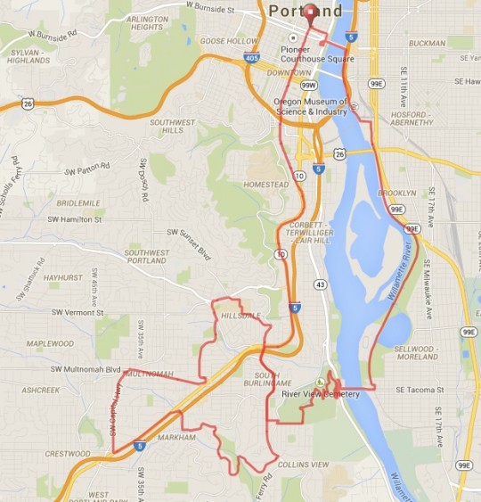
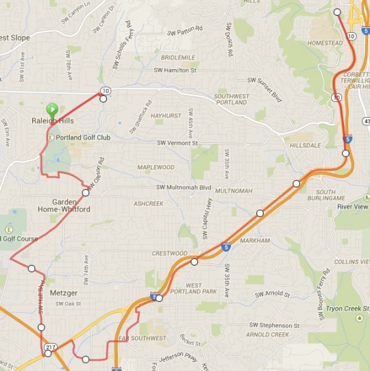
Let’s start with a bit more exploring. Here’s the route I did last Wednesday…
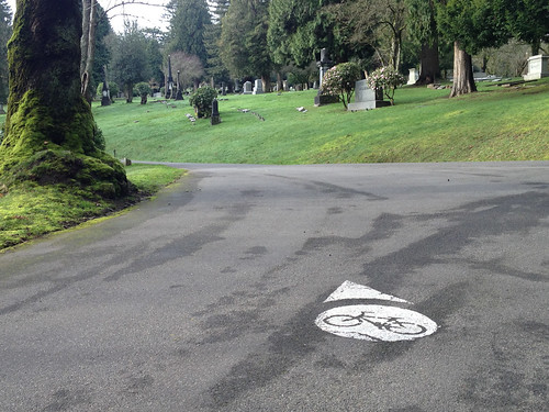
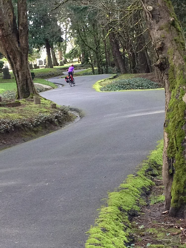
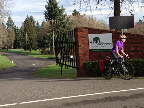
On Wednesday I decided to use the River View Cemetery approach. I headed south from downtown, connected to the Springwater Corridor path, crossed the Willamette on the Sellwood Bridge, then shifted into an easy gear and pedaled through the cemetery. After riding through Washington Park the day before, it dawned on me how crucial these off-highway routes are. Given the sad state of bike connections between southwest and the rest of Portland, that area of our city would be even more isolated without Washington Park and River View Cemetery.
Especially the cemetery. After all, unlike the park, it’s a private business that graciously allows bicycle access through their hallowed grounds. And it’s a very nice ride to boot, as long as you don’t mind the 1.6 mile, 377-foot climb.
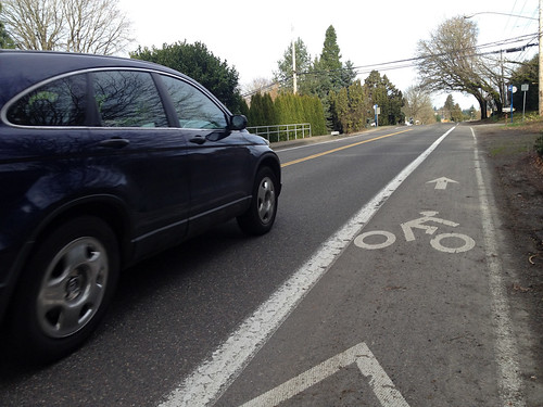
The end of the marked bicycle route (which you must follow in the cemetery) dropped me onto SW Palatine Hill Rd and from there I continued west and connected to SW Terwilliger. The bike lane on this section of Terwilliger is narrow and it doesn’t instill much confidence.
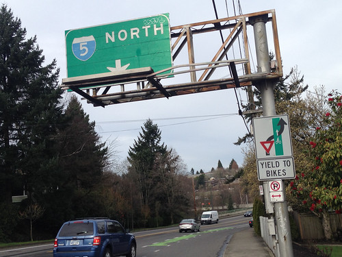
Speaking of confidence, you need quite a bit of it to merge left across Terwilliger at the I-5 freeway on-ramp…
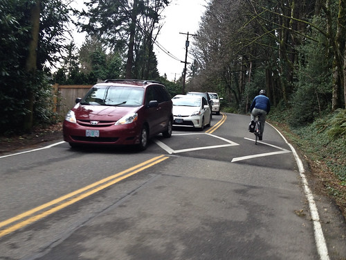
From Terwilliger I decided to check out some neighborhood streets, so I decided to try and reach the Hillsdale shopping center via SW Vermont Street. From a biking and walking perspective, Vermont is one of the most important streets in the entire southwest road network. It’s a straight, three-mile long east-west neighborhood collector that connects several schools, parks, and residential and commercial destinations. In southwest Portland, a straight neighborhood street that’s relatively flat is as precious as gold.
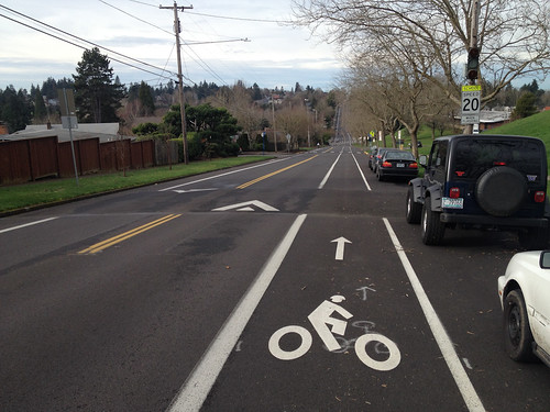
Because of that, Vermont has been the focus of attention from the City of Portland. PBOT has added speed humps, bike lanes, and sharrows to some parts of Vermont. Here’s how it looks at its eastern end outside Wilson High School and Rieke Elementary School…
Later in the day I met up with southwest Portland resident and uber-advocate Roger Averbeck. He gave me a guided tour of what he and many others feel is the highest priority active transportation project in the entire quadrant: A redesign on SW Capitol Highway between Multnomah/Garden Home and Barbur.
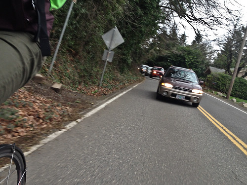
On our way to that future project site, Averbeck showed me SW Capitol Hill Road, what he calls a “classic southwest neighborhood collector.” It’s got speed humps, but there’s absolutely no shoulder (even though there’s plenty of unused right-of-way) and — with infill development on the rise — the auto traffic volume is ever-increasing.
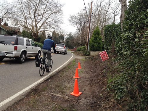
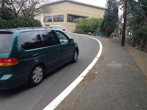
At the southern end of Capitol Hill Rd (where it meets up with Barbur), Averbeck showed me how the street was impacted by a new Safeway development.
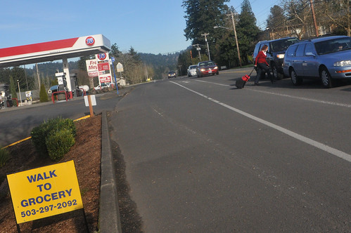
Averbeck and other activists pushed Safeway to build a sidewalk, but they said it would be too expensive. Fortunately they compromised and installed what he refers to as a “widened shoulder.” It’s not a full-fledged sidewalk, but it’s much better than nothing.
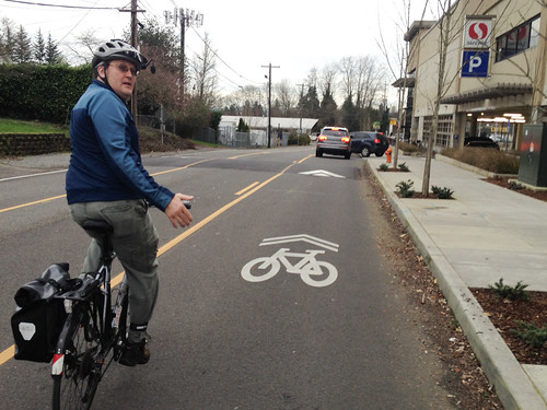
Then, as we approached Safeway, Averbeck somewhat disgustedly pointed out that the grocery giant declined his request for a bike lane to access the store and instead merely laid down a few sharrows.
Advertisement
After I parted ways with Roger, I headed north on Barbur Blvd. I don’t usually venture this far down Barbur, so it was a good reminder to see and feel just how auto-centric and stressful it is to bike on.
I wanted to get east over to Terwilliger, and using my trusted PBOT bicycle map, I turned off Barbur at SW 26th and followed some of their recommended routes: Taylors Ferry Rd to 18th Place to Maplecrest to 12th. As is usually the case in southwest, taking side roads meant lots of curves and hills. The bad news with these type of roads and topography is that it adds time, distance, and lactic acid to your ride. But the good news is that it’s quite beautiful.
Just a few minutes away from the roar of Barbur Blvd, I was riding next to the roar of Tryon Creek through the lush green trees of Marshall Park.
This little cut-through popped me out on Terwilliger just a few blocks south of Palatine Hill Road where my loop began.
On my final day of explorations in southwest Portland I decided to trace the rim of the Portland city limits.
After waking up early to join Ali Reis for her daily commute, I rode into Raleigh Hills. From there I headed south on SW Scholls Ferry Road and (once again) used the Fanno Creek Trail to connect to SW Oleson Road. Both Scholls and Oleson have bike lanes, but they are standard width and you’re sharing the road with people driving 35-45 miles per hour. It’s not terrible for someone like myself, but it’s not exactly pleasant either. As for walking, that’s another story…
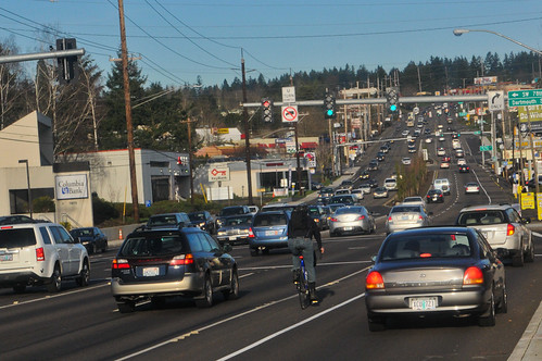
At the southernmost point of my entire week, I rode in the bike lanes on SW Hall Blvd to Barbur Blvd. This was a Barbur I had never known prior to last week. I think I was actually in Tigard at this point. Looking north at the intersection of Barbur and 76th, I got a great view of the roadway cross-section…
I did a little sidetrip onto SW Dartmouth through a big-box shopping center (was looking for new location of Western Bikeworks store but couldn’t find it). I wanted to get back onto SW Barbur but it wasn’t as easy as I hoped. I found myself on steep curvy roads with little to no room for a bicycle rider and an auto user to coexist. At one point on a narrow road I looked down and saw a massive open drainage culvert off my right shoulder while people revved their engines while driving past me on the left. In some ways I was relieved when I re-connected to the bike lane on Barbur.
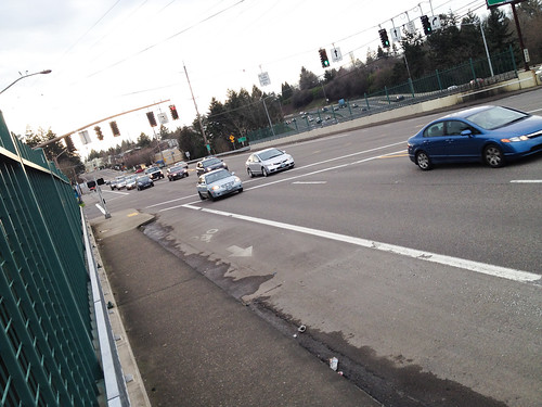
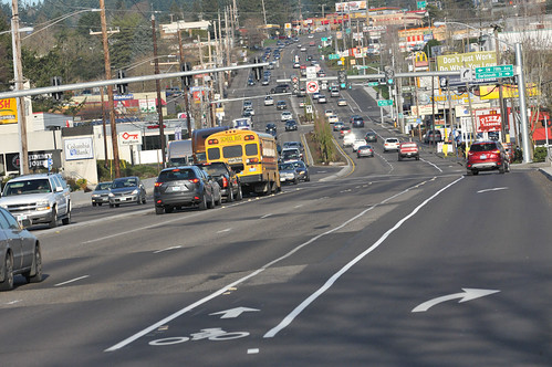
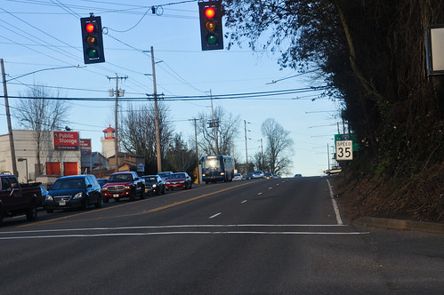
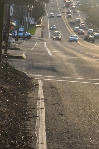
But then this happened. I was happily pedaling in the bike lane when, at the intersection with SW 24th, it just completely dropped me. Here’s what I saw at the red light…
Then I pulled over and looked back (south)…
How can we so wantonly eliminate a lane of travel dedicated to a certain type of road user and then provide no other place for them to go?! This is what we’re up against all over southwest Portland — and especially on Barbur. So infuriating.
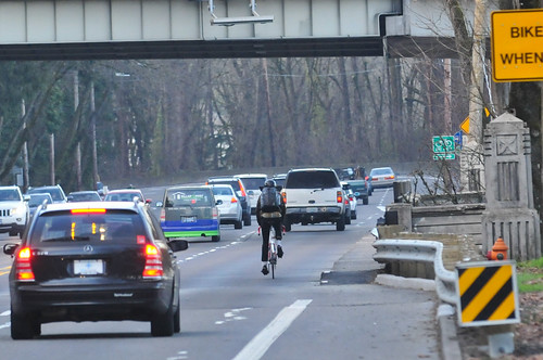
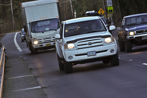
As I got further north and into more familiar stretches of Barbur, I decided to stop and do some observations. I finally got some good photos of the oft-talked about Vermont and Newbury Bridge pinch points in action.
Would you want to share a lane here?
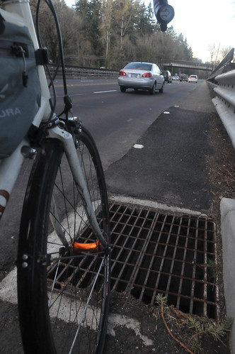
And since ODOT recently improved the sidewalks on the bridges, so they could potentially be used by folks who don’t have the confidence to take the lane, it was pretty sad to see this storm drain grate right at the bottom of the new ramp leading up to it…
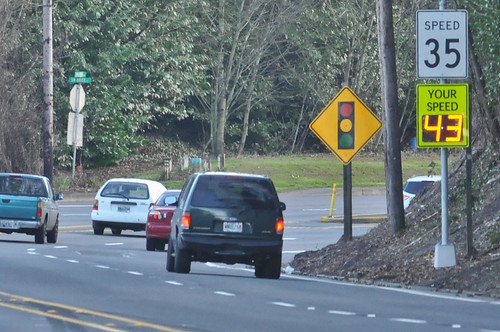
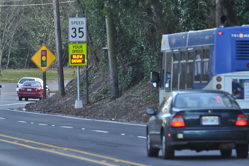
I also did the same thing Michael Andersen did when he was here earlier in the week. I photographed the rampant speeding that takes place all the time on this crucial bike connection (you can’t see it, but there’s a bike lane right underneath that speed reader board)…
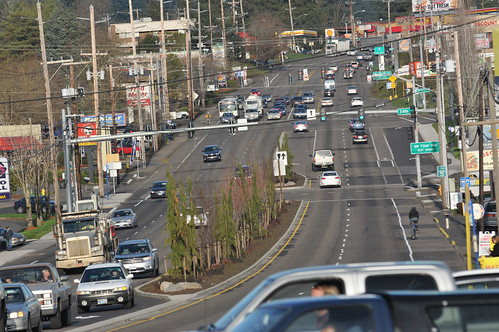
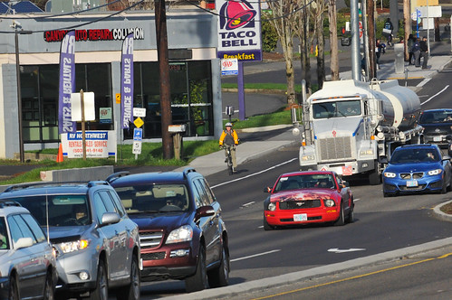
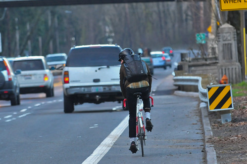
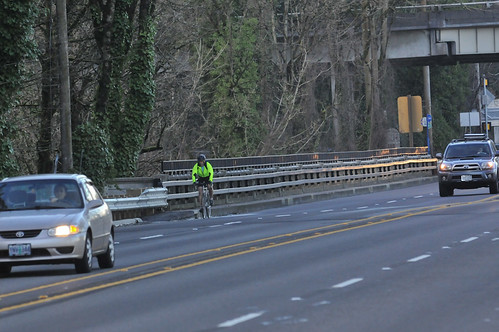
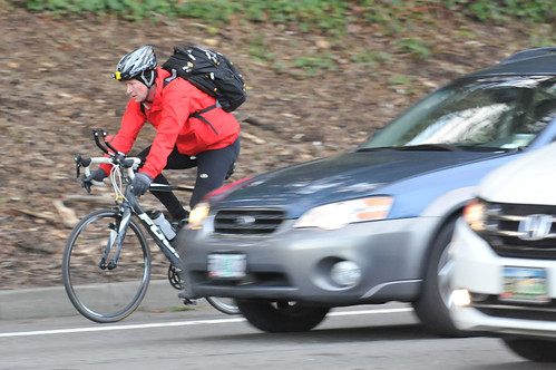
Speaking of this being an important bike connection, here’s what the bike riders look like on this stretch of Barbur…
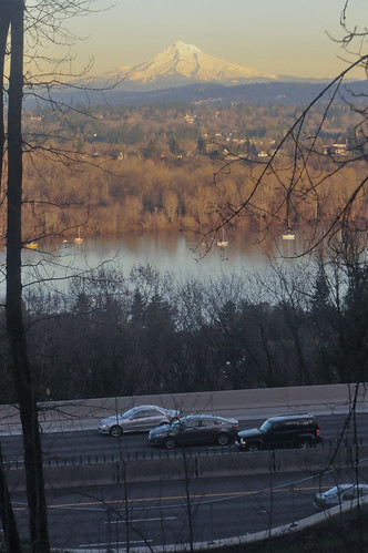
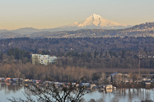
Unfortunately, I bet some of those folks who have biked here for many years, have never felt like stopping and taking in the views. I don’t blame them, given that the human instinct tells us to flee danger as quickly as possible. But I was there to observe, so I pulled over and took in the view…
It was a reminder that this is still a beautiful place — we’ve just allowed it to become dominated by motor vehicle traffic at the expense of everything else.
— Stay tuned for our final wrap-up post that will summarize everything we’ve learned after our week in southwest Portland.





Thanks for reading.
BikePortland has served this community with independent community journalism since 2005. We rely on subscriptions from readers like you to survive. Your financial support is vital in keeping this valuable resource alive and well.
Please subscribe today to strengthen and expand our work.
Love it when you and others post clear ride directions, esp in areas I’d not otherwise wander off to, like the SW. Thanks. Oh, and a flea *could* be dangerous (just a paragraph or so up) 🙂
This post perfectly describes the frustrations with SW (to be fair, a lot of other areas too). Adequate to good infrastructure that suddenly disappears, even for just a few hundred feet. In the 1800s, we didn’t build railroad tracks from East to West coast, only to leave the 50 feet right in the middle of the country unfinished because that last bit was too hard to build. If you are a parent considering taking your kid to preschool by bike with great lanes the whole way there EXCEPT for 20 feet of certain doom, that short section decides whether or not you ride of drive. That reference above is a personal one for me. The photo just after “Then I pulled over and looked back (south)…” is the short stretch that holds me back from taking my kid to St. Clare’s just off that next turn on Barbur.
good way to put it really… it’s either a bike lane or “20 feet of certain doom”, which makes it very stressful… like every day even after the 300th time, you dread it.
The Transcontinental Railroad was completed in 1869 but lacked a connection across the Missouri River between Council Bluffs and Omaha until 1873, so it had a small–and more significant!–gap. Nonetheless, of course, your point still obtains.
Thank you for visiting our oft-neglected part of the City. The other wrinkle with those old timber bridges on Barbur is that they represent the two areas along that corridor between Terwilliger and Hamilton where the roadway lacks any illumination. Right as we are asked to merge into 45+ MPH road traffic at those pinch points the roadway light levels drop to zero at both locations. Ugh…
Thanks for the great shots and tremendous coverage throughout the week. FYI, bike/ped gaps between SW 19th & SW 26th should be completed along Barbur as part of the “Barbur Demonstration Project” to be built sometime in 2016. You might verify with the city, but I have been repeatedly told this project is funded and “in the works.” The gaps north of the Safeway and just beyond the Golden Touch restaurant on either side will presumably be “fixed” by virtue of the fact Natural Grocers is planning a development with several hundred apartment units and underground parking in the present Golden Touch location. Again, ODOT and the city need to be held accountable for making this an active-transport friendly development.
A few last questions on the ODOT speed reader: Why is there only one in the Southbound direction, but not Northbound over the bridges? Assuming speed data is recorded does ODOT have statistics on what percentage are breaking the law in the form of going over the limit? Based on what I’ve witnessed is has to be over 80% are exceeding the limit into that uphill speed reader. What might they expect in the downhill direction?
Thank you for joining the infuriation.
I loved the articles. It has been pretty great going from the feeling of being one of the only die hard bike commuters in 1995 to being one of many bike commuters in SW today. The numbers drop significantly in the winter, but so does the volume in rest of the city.
Thanks for visiting our woodsy neck of the woods. If nothing else I hope BP readers gained an appreciation for why we see so much potential in Barbur Blvd.
I have thoroughly enjoyed the reporting all week. Thanks for taking the time, and biking out there every day this (last) week!
“we’ve just allowed it to become dominated by motor vehicle traffic at the expense of everything else.”
Can I nominate you for quote of the week? 🙂
That shot of the lane drop on Barbur at SW 24th is why my ride home from PCC now involves a big ‘S’ curve following Capitol Hwy, backroads, Multnomah Blvd., the ramp complex connecting NB I-5 and Terwilliger, followed by a left onto Terwilliger back to Barbur.
I haven’t lived in SW in years but seeing the picture of that dropoff put the terror right back in my belly. Many a time I pedaled and prayed as hard as I could in that little stretch when late to class at Lewis & Clark.
Build the Red Electric Trail!
Disappearing bike lanes are a problem EVERYWHERE in the city.
We had to fight to get the new bike lanes on Foster continuous out to the 205 path (because it completely makes sense to stop bike lanes for 10 blocks before a major multi use path). Even still we didn’t get bike lanes all the way to 52nd, and have the funky neighborhood jog.
I think it becomes clear that many transportation folks view bike lanes/routes as a luxury and that cyclists should just be happy with what they get, rather than actual, continuous routes to get places. As you described in the article and pictures. What are cyclists supposed to do when a lane ends? Just stop and turn around? Or go searching for some random side street route this is rarely ever well marked? No, we’re expected to just merge with the traffic and deal with it.
I don’t think they understand that it devalues every section of bike lane when you have it just dead end into nothing.
“No, we’re expected to just merge with the traffic and deal with it.”
Correct. Not great but also not the end of the world.
“I don’t think they understand that it devalues every section of bike lane when you have it just dead end into nothing.”
It does communicate unequivocally where bicycles fit in our transportation landscape, how much of a priority it is to complete this network. But I think it is also worth remembering that some of us have been merging with traffic, biking on the shoulder if there was one, all our lives. It does work. Practically speaking there isn’t even all that much difference between biking in the right sixth of the lane (for fifty yards, as in the photo) vs. in a bike lane. I biked that stretch with my nine year old daughter a few weeks ago, and I did notice the abrupt end of the bike lane, but we dealt with it. It didn’t ruin our overall experience, or make us not want to bike there ever again.
there’s more people now though, and one anecdote does not make a trend.
On some levels I agree with you, and I’m definitely one of the kind of people on here who often wonders why people complain so vehemently about bike facilities in this city and don’t stop and realize how great we have it (Almost all our bridges have bike and pedestrian access, that’s awesome!). But I don’t get the idea of spending the money on making a bike facility and then not making it continual. If that’s what they’re going to do, i would almost have them just not build it all together.
and as DMV pointed out, there are a ton of lower confidence riders out there who will only take greenways or who will only take bike lanes. Discontinuous bike lanes are a big deal for them.
by more people, I meant more people driving… so when you talk about how it was back in the day, it’s not really a good comparison. Stuff’s different now with phones and huge SUVs, a certain sense of bitterness and intolerance, and just really… too many people who have already made the turn onto the highway in their minds 300 yards before the fact.
Good point!
There is something like the Vermont-Illinois bikeway amd the city made a Neighborhood Greenway out of SW Illinois (you reported) and added bikelanes to the section of Vermont between Capitol Hwy and Terwilliger. However, a crucial missing link is still Vermont between 30th and 34th westbound. The city just finished a sidewalk on the soutside (eastbound) and it is a good example how a sidewalk project improves biking as well. We went from just the fogline for bicyclists and goat trail through the brush for pedestrians to a nice wide siewalk and bikelane. Due to money restrictions the city only built the sidewalk one side and promised an extended shoulder with a MUP for bikes/peds on the north side as part of said Illinois-Vermont Bikeway. So far this hasn’t happened and it is a scary section where Vermont goes from two lanes to one with a little bit if gravel shoulder and parked cars and heavy traffic. So just paving that gravel shoulder and prohibit parking for a few blocks would make a huge difference and close the gap on the bikeway. We have to go through this section on our Hillsdale to Hayhurst biketrain and it’s very scary with the kids (as well as for more seasoned bike commuters, especially in the dark).
Nice coverage of bike issues here in Southwest. I’ve seen quite a lot of progress over the last couple of decades, but there’s clearly still a long way to go.
One thought that occurred to me recently as I sat on my bike and watched car after car go by with only one driver: Virtually every policy-maker and agency profess that we need to move away from people getting around by driving alone in their cars. Yet the vast majority of our transportation planning and infrastructure aim at accommodating precisely that mode of transportation. Why? If we making it safer and more pleasant to move by bike and foot and public transportation, people will continue to change their transportation behaviors.
I would answer:
“Virtually every policy-maker and agency profess that we need to move away from people getting around by driving alone in their cars. Yet the vast majority of our transportation planning and infrastructure”
is conceptualized, voted on, built, and maintained by people who got to work driving alone in their cars.
To me that is the answer to your question.
Welcome to Tigard! We’re getting better, really. Slowly but surely.
New boardwalks to finally connect SW Johnson Street to downtown Tigard.
And lots of sharrows on Main; wish they’d add two more on Burnham, the ones that they put on that street are improperly placed (not immediately after you turn onto the street on either end or at the Ash St intersection, and then periodically on the street surface).
Like I say, Tigard’s trying…. but are sometimes hampered by ODOT. And sometimes helped, as was the case on 99W in the new construction zone between Freddies and 217.
I have to say that while I appreciate the in-depth look at bicycling on the west side, the reports and photos confirm why I basically spend almost no time or money in SW Portland. Without a car, and with transit access more limited and infrequent than on the east side, there’s basically no compelling reason for me to stick my neck out by riding my bicycle in such an unwelcoming — and too often, unsafe — part of town.
Not even for Oregon’s only Velodrome, and the expanding and new bike stores, the new Sellwood bridge, removal of parking on Oleson to make new bike lanes?
Bus 56 and 54 on Scholls Ferry and BH Highway are among the most frequent and most-used TriMet buses. Plus, TriMet has proposed and has gotten good reception to have the 56 go all the way up Scholls Ferry to the Washington Park area.
Beth…I’d encourage you to not come to a negative conclusion based on the motor vehicle traffic heavy photos in this story, about riding in the SW area. On other roads in the area, there’s good, enjoyable riding. The Barbur Blvd-Pacific Hwy route happens to perhaps the worst route for biking in the entire area. Avoid Barbur on your bike, and some of the other major roads like Beaverton-Hillsdale if possible, and you’ll be fine.
BH Highway has gotten better with the wider bike lanes.
We have actually excellent transit access in Hillsdale with 8 bus lines that stop here, 3 of them (45, 54, 56) frequent service. We have wonderful local stores, restaurants and cafes here. Come check it out! Mulnomah Village does not have as many bus line, but is still easy to reach and has more great local stores and restaurants.
Love the shots of Mt. Hood with the funky yellow haze hovering over the landscape. Shows exactly why I commute by bike everyday.
With Mt Hood 60 miles away shown in crisp relief the yellow haze is actually faint. We live in an city that actually has good air quality. Anyone who exercised in LA in the 60s or 70s and could not see mountains merely 5 miles away would relish this air like it was a fresh crisp apple. The alternative transportation accommodations in SW are terrible as this article clearly shows, but cycling in this area is pretty darn good.
Thanks to Jonathan for another good article
“…How can we so wantonly eliminate a lane of travel dedicated to a certain type of road user and then provide no other place for them to go?! …” maus/bikeportland
Check with ODOT to see if, at that point on the road, the bike lane was actually eliminated. Could be, but I doubt it.
Barbur Blvd and Pacific Hwy, are roads on which, not so long ago, there were no bike lanes…at all. Over the years, bike lanes have not been eliminated from the road, but instead, added to it.
Some of the pictures give an indication of the steepness and length of climb that people riding this road have to deal with. These roads get huge amounts of motor vehicle traffic usage through many hours of the day. People riding alongside that traffic, breath the foul exhaust, hear the loud traffic noise, and have to fight off the stress of being in such a heavy motor vehicle use setting. Not healthy conditions to be riding in.
Capitol Hwy: definitely continue and expand efforts to keep increased motor vehicle usage of this road from making it an unhealthy route for walking and biking. On area livability, infill can have both good, and bad results. Dramatic, overwhelming increases in motor vehicle usage on roads accessing infill areas, are often one of the bad results.
Thanks so much for covering it! SW Portland (and the west side in general) have their car dependency issues, but some of the routes are amazing and need to be shared.
Here are some of my favorites:
Climbs: Kingston, Montgomery, Patton, and Hall (just for the view)
Rolling: Fairmount, Hewitt, Humphrey, Hamilton
Descent: Broadway (and there’s nothing even close)
Best for commuting: Montgomery and Hewitt
Do you mean SW Hall Blvd? Did you hear about the possible trail for SW Humphrey blvd?
“…possible trail for SW Humphrey blvd?” Andy K
rick…got details?
The is a property near SW Humphrey Blvd that is possibly being considered for redevelopment of homes and some planners / neighbors want a north / south trail because it is not currently a walkable neighborhood:
http://swtrails.org/?s=humphrey
Clicked on the link you provided, which leads just to the minutes for the SW Trails group. Down from the top quite a ways, is mention of a Humphrey, Greenhill Way trail, though no map of a proposed route. Humphrey isn’t so good for walking, or biking. Too much traffic, shoulders aren’t consistently wide enough to allow people on foot somewhere to get away from motor vehicle traffic.
Though a north south trail in this area may be a good thing.
Also would like to bring up the more or less off topic subject of remaining undeveloped lots on Fairmount Blvd south, gradually being sold off to have houses built on them. These undeveloped lots allow, still from a number of points along the road, views out over the valley, and in some cases, down into lush ravines along the road.
Each additional house built, blocks those views to the many people using this road for recreation by means other than motor vehicle. I wonder to what number, the city may have in mind to allow viewpoints along the Fairmount Blvd south side to be reduced to. Too much money for the city to buy up the remaining undeveloped lots, I suppose.
The trail, at those meetings wasn’t opposed by the possible developer. I don’t think the lot has been redeveloped. Portlandmaps.com shows many unbuilt public right-of-way in the upper hills in SW.
Jonathan, how did you get from the end of Ali’s route to the start of this route? Did you go through the Beaverton-Hillsdale/Oleson/Scholls intersection? The intersection the locals call “Crash Corner”?
That’s part of my bicycle commute to work. Westbound is the more “interesting” direction, which is how you must have went.
How was that intersection for you?
The maps from the SW bike week shows he went on SW Laurelwood to Scholls to 86th to the Fanno Creek Trail.
This ride stopped east of crash corner by Parr Lumber. There is an alleyway with nasty speed bumps behind the shoe store / Noodles Restaurant.