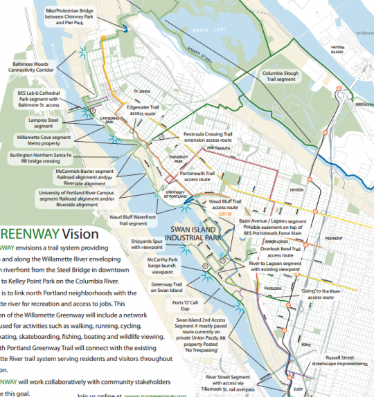
The 50-year-old vision of a continuous mixed-use path along the east bank of the Willamette River, connecting Kelley Point Park, on the tip of the St. Johns peninsula, to the Steel Bridge, has made it on all the planning maps.
Now, the little nonprofit that has brought the concept this far is preparing for the last stage: getting it on the ground.
Thanks to a $50,000 capacity-building grant from Metro awarded last fall, the nonprofit North Portland Greenway organization is preparing to hire its first dedicated staffer, a consultant who will spend up to 10 hours a week preparing for a transition on npGreenway’s volunteer board.
“I think this grant will be the tool to take our organization to the completion of the trail.”
— Joe Adamski, npGreenway board member
“In 10 years we’ve done an awful lot, but we know there’ll be another 10 years before that trail is completed,” said Joe Adamski, a longtime npGreenway board member, in an interview Tuesday. “We’re now at the point where we’re pushing and agitating for building and finding the money and the support. And we couldn’t put a website together if our life depended on it. Twitter? We’re all 60 or 70.”
Adamski said most of the existing board consists of people with experience in planning rather than in political action.
Key political challenges for the group include lining up enough money to build the path and to secure the building rights from landowners like Union Pacific Railroad and Ash Grove Cement, two companies that control the crucial segment between the Swan Island industrial area and the Broadway Bridge area.
Advertisement
In 2013, we reported that the city, UPRR and advocates were discussing an inland route just south of Greeley that would avoid the contentious Cement Road, an existing private road near the shore that is crossed by rail tracks and used by Ash Grove cement trucks.
“The connection to Swan Island is going to be the crucial place that’s going to drive the whole trail,” Adamski said Wednesday. “We will support that alternate line [south of Greeley], but we still have a preference towards the Cement Road alignment. The reality is that if it’s going to happen, probably it’s going to be that alternate Greeley alignment.”
UPRR’s concession to allow an off-road path on the south side of Greeley, rather than forcing it to be built into a hillside north of Greeley, came out of a 2013 meeting attended by UPRR, U.S. Rep. Earl Blumenauer and Mayor Charlie Hales.
npGreenway has already retained Bill Weismann of Grassroots NW to complete the first phase of their 18-month project, which is to develop a strategy that’ll be carried out by the board and its part-time staffer during the longer second phase.
Adamski said the group aims to be ready to bring on its second-phase staffer by late March.
“I think this grant will be the tool to take our organization to the completion of the trail,” Adamski said.


Thanks for reading.
BikePortland has served this community with independent community journalism since 2005. We rely on subscriptions from readers like you to survive. Your financial support is vital in keeping this valuable resource alive and well.
Please subscribe today to strengthen and expand our work.
A pedestrian / bike bridge is needed over the Willamette River in order to connect the University of Portland to North Channel Ave.
Moving the bike lanes on Greeley and Willamette to be bi-direcitonal on the west and south sides would go a long way to making a nicer cycling environment in NoPo
I agree that this is good solution for Willamette from U of P to Rosa Parks, but I disagree with putting a recreational facility along Greeley. I believe there is room for a very pleasant trail down the bluff, through the forest, with river views, from just south of Ainsworth to Going Street. This would have the added benefit of connecting a lot of neighborhoods to the river in a meaningful way.
An improved Greeley may be acceptable for commuters, but it would never be a pleasant place to experience the river
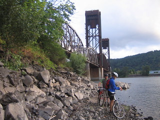
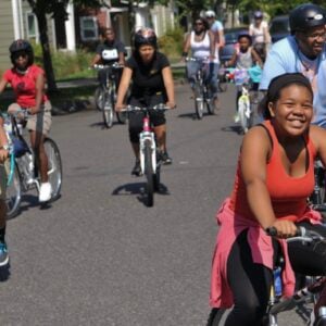
>Photo: npGreenway
Oof, people need to stop going to the beach at Willamette Cove (where that photo is from). There is quite a bit of contamination there that has not been addressed.
Thanks for mentioning this, I found this OHA report when googling “Willamette Cove” —
Good to know. I understand this part of the upper Willamette has some of the worst contamination, makes me wonder if the Swan Island beach has similar conditions.
Page 279 of this BPS report seems to indicate that the Swan Island beach is not a priority, though other parts of the area are of concern. https://www.portlandoregon.gov/bps/article/158903
Just wear some sandals. I cut my foot after 1 minute on a piece of broken glass on the Swan island beach. No fun.
“The highest lead level from this area was 13,400 ppm”
YIKES
Yes that’s me in the picture. Luckily, I didn’t put any dirt in my mouth and survived unscathed.
This is great news! I attended a number of the meetings led by PPR and I hope their report does not set this project back too far! The Parks plan took the path of lest resistance at the expense of advocating for a trail hat could a safe AND pleasant route north along the river that is river-focused! I believe a very crucial piece of this plan is between the Steel Bridge and the traffic signal at Larrabee. I believe the recommended plan shows a route using the Larrabee viaduct and shunting bikes behind the back of the MODA center- this is a terrible idea that drives people away from the river and forces bikes to climb a lot of unnecessary grade! I would love to see a plan illustrating the Larrabee Viaduct being used for ALL motorized vehicles (retaining a bike land and adding a sidewalk to access the Broadway Bridge). The southbound lane of Interstate Ave could then be closed from Tillamook to the signal at Larrabee adnd converted to a 2-way MUP for bikes and peds! South of the Broadway Bridge, the path route could swing west to the top the bank and continue there to the Steel bridge. At this point, the most exciting option I see is create MUP viadcut under the Steel bridge, but over the railroad gravel access road; the viaduct would tie in to the Esplanade.
At Tillamook, the connection to the proposed route along the east edge of the railyard is difficult to access. Either the MUP could head down the south side of Tillamook and then cross the tracks at Albina, Lewis, Clark or Harding, or a new signal would get the MUP across Tillamook and a new ramp would take bikes and peds down between Interstate and the railroad.
The Cement road was preferable because it allowed users to travel near the river and kept track crossings to a minimum. It also brought users to one of the prettiest stretches of the route along the beaches of Swan Island! If this route cannot happen, then the Swan Island section becomes an important spur, but a part of the main trail. I would advocate that the main trail stay at the base of the bluff, or on the bluff. The route could pass under Going and I could see 2 great options here: The first option would gradually climb the bluff, joining Willamette Blvd just south of Ainsworth. To create a pleasant safe route, Willamette Blvd could be converted to one way northbound, and the southbound converted to greenway between Rosa Parks and University of Portland! At the Waud Bluff Trail, the path would descend, but after crossing the bridge over the RR tracks, the route would descend (not stairs!!) and continue along the water’s edge to Cathedral Park! The second option would continue on the bluff to the Waud Bluff Bridge.
I am a very enthusiastic supporter of this idea, and I cannot resist an opportunity to push for excellence. The last planning project operated on an assumption of “what will cyclists tolerate?” and we got a route along Greeley, and behind the MODA center. Going forward, I would love to see the beauty of the river and the escarpments considered as well as the potential value of this as a recreational amenity for a broad range of users including children. Way to go NP Greenway folks, and thanks for the update Bike Portland!
I am a web developer and would be able to offer some of my time to build a website and Twitter presence for free. Michael, do you have a contact with the project I could talk to about this?
Hey, Adam, the npGreenway website is http://www.npgreenway.org/. I’ll email you Joe Adamski’s contact info.
Thanks!
Timely question, yes and thank you on behalf of the npGreenway board! Shoot me an email and we’ll get this on the next Board planning meeting.
(Hi Adam, see my post below…)
Great news! Congrats, Joe, and best wishes!
I’m not sure how well it applies to this project but I like this philosophy from a comment on Seattle Bike Blog about the new Kirkland trail:
The thing that really sticks out is how fast Kirkland moved on the basic improvements along the whole thing, presumably without spending all that much money (around here spending money takes time). This stands in stark contrast to their intention to master-plan the hell out of the final trail and spend a lot of time and money doing it.
So please believe that I understand fully why the preference is there for the cement road connection, especially given the existing path near daimler that is intended to tie in there. However, I would like to present one distinct advantage a greeley based alignment would have. You have to get to the top of the hill by the time you reach U of P whichever way the greenway would be aligned, and currently there is a set of stairs where a cement road/swan island based path would connect. By taking Greeley, you can actually ride up the hill, avoid the industry of swan island and pass by it on willamette instead.
I know that a path alongside greeley would be noisy, but perhaps some noise reducing shrubs could be planted between? It would be off street anyway, so at least the 55+ mph traffic wouldn’t be such a concern.
Anyway, I just don’t like having to get off my bike and carry it or push it around, especially if loaded with heavy panniers. Is there some other plan to avoid the U of P stairs?
Ideally, the Greeley parallel alignment will serve N-S commuters, take them off Greeley AND provide safe access that’s critical to Swan Island’s 11,000 and growing employment base. This would be an engineering feat (and not cheap), but a cantilever off the Greeley overpass at N Going could achieve this provided a long enough approach for grade reduction up to this point.
resopomok,
I share your opinion that avoiding the dangerous industrial roads/driveways on Swan Island may be desirable for the main path (although it is so cool, and so beautiful there needs to be a spur!). However, I disagree that Greeley is a viable option. I believe a very nice trail along the bluff from Going to either just south of Ainsworth or to the dead end of Basin. I outlined this in my post above. When PPR planned this route, they took the position “what will bike commuters tolerate?” and came up with the Greeley route (and the diversion around the MODA). I hope that going forward, people will set the bar higher and work to create a path that is beautiful and connected to the river, a path that is safe and easy to follow and inviting for parents, kids, dog walkers, and a path that offers meaningful connections to the river. The bluffs are a a unique topographic feature formed by the river and containing a lot of great native oaks and other cool plant communities. I see a lot of value in running a path up or along this bluff with great river views. A separated path along Greeley will simply never be nice or safe or attractive and is only connected to the river in that it very loosely follows its course
I would like to thank everyone for their interest in npGreenway. Connecting North Portland to the jobs at Swan Island , the east bank, downtown and the esplanade is an exciting idea with tangible results. One point I would like to make that I don’t see expounded upon is that the goal of the grant is building board capacity. We need to learn to operate as a board that can translate its goals into action with communication, fundraising ,political action and other goals we have prioritized.
Building a website is a short term goal: providing ongoing content and communicating our successes, our calls to action, our concerns is a tougher piece. We would like to LEARN to engage our supporters, achieve our goals with their support, and develop the next cadre of leadership who will take their experience and lessons to everything they do. I use a website as a ‘for instance’ but the same needs apply to all we seek to do. We will, in short time be asking many to help us do those things that will support the realization of the npGreenway. But our immediate goal is to build the leadership core that will take on that task. You may know you want to take on the challenge, and I would want to have that conversation with you also.thanks again!