After we posted a story yesterday about a Milwaukie real estate owner who plans to demolish his retail building on Main Street and build a parking lot, we heard from a few readers who worried their hometown was getting a bad rap.
Truth is, there is a lot of positive momentum for bicycling and livable streets in Milwaukie. Reader Matt Menely has been advocating for bikes in Milwaukie for many years. He got in touch to tell us about tonight’s city council meeting — which has an agenda that’s chock-full of bike-related projects.
Advertisement
Here’s Menely’s email:
Tonight (Thursday) City Council is meeting at 5pm for a study session to discuss some of the good stuff. They will be discussing the following bike related projects that are currently underway. Feel free to show up and learn more about these important projects. This is happening at the City Hall Conference Room (10722 SE Main Street).
5:00 p.m.- 17th Ave Multi-Use path. This will connect the Trolley Trail to the Springwater Trail, and we have secured the money to build it! (Read BikePortland story on this project.)
5:30 p.m.- Street Surface Maintenance Program: Railroad Avenue Project. A multi-use path and/or bike lanes will likely be part of this conversation. This is a much needed connection that would get people out to the Aquatics Center, and to the Clackamas Regional Center beyond.
6:00 p.m.- Safe Routes to Schools Program – There is plenty of overlap between the Safe Routes Program and the improvements that will be proposed as part of the Monroe Neighborhood Greenway plan, as well as a future Stanley Ave Neighborhood Greenway.
If you want to stay abreast of these projects and all the other great bike stuff in this cool city just south of Portland, check out the Bike Milwaukie Facebook group.


Thanks for reading.
BikePortland has served this community with independent community journalism since 2005. We rely on subscriptions from readers like you to survive. Your financial support is vital in keeping this valuable resource alive and well.
Please subscribe today to strengthen and expand our work.
Related to this, here is something that was sent out on the Sellwood-Moreland listserv a few days ago:
An emerging transportation issue in the neighborhood is a bicycle-pedestrian trail that the City of Milwaukie is planning to extend along the west side of 17th Ave. from the City of Milwaukie to St. Andrews Drive (the exit from the Garthwick neighborhood). While most people consider the trail a positive development for the neighborhood, connecting the north end of the trail to the Portland trail system (primarily the Springwater Corridor both west and east) presents some problems. Below is an email from the City of Portland explaining the issue and a proposed interim route for connecting to and from the Springwater Trail to the west and north.
I will have this issue on the agenda for the Transportation Committee meeting Jan. 21 (separate announcement coming soon on that). The issue also will be on the agenda for the SMILE General Meeting beginning at 7:30 p.m. Wednesday, February 4, and I hope to have some public officials at that meeting to explain their perspective and hear comments.
Here is the email from the City:
Hi Brian,
I had a field meeting with a City of Milwaukie commissioner yesterday at the intersection of SE 17th Ave and SE Ochoco St. The City of Milwaukie is currently designing a new multiuse path which will extend north from their existing Trolley Trail up the west side of SE 17th Ave to the Portland city limit. They would like to formally connect their facility with our network. Unfortunately, due to the existing rail crossing at SE 17th Ave/Ochoco St as well as our future pedestrian improvement at SE 17th Ave/Linn St, it is very difficult for us to make a reasonable connection from the City of Milwaukie facility to our own. As an alternative, I am hoping we can use SE Andover Pl as our connection at least until we are able to fully extend the Springwater Corridor’s missing link (which will take care of this whole situation). I have attached a couple of diagrams showing the concept. The key features are as follows:
· The design converts SE Andover Pl back into a two-way street [east] of SE Exeter Dr
· The design retains the existing DO NOT ENTER condition for motor vehicles at SE Exeter Dr
· Two parking spaces must be removed to create the contraflow lane
Do you think this is something the neighbors on SE Andover Pl would find acceptable? Thanks for looking into this. Let me know if you have any questions or concerns.
So excited for the 17th ave path!
And the riverfront park is being rebuilt. the boat ramp is relocated, open space is reallocated for both active and passive recreation, and the confluence of Johnson Ck. and the Willamette has gotten restoration work so nature viewing makes this a great destination for cyclists. Few of us remember Vic’s (dive bar) which used to occupy the space, but with only 2 of the 3 phases underway for the park project the improvement is already significant.
I was a little bit of a smart aleck on the last Milwaukie article, but I truly am impressed with some of the bike related projects I see going on there, and I especially like the Trolley Trail as a connector between Milwaukie and Oregon City. Keep it up, and we will be playing catch up here to your south!
I’m excited for the 17th trail, esp. if they also keep (and hopefully improve) the current bike lanes. nice to have both options on a bike for different kinds of uses (commuting/training vs. families/cruising/runners/walkers/etc.)!
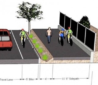
It looks like it will retain the northbound bike lane, but the southbound bike lane will go away when the project is built. There is not enough right of way to fit everything in.
So that picture is just wrong?
Yes, that picture is out of date. It was from the original grant proposal in 2011, and the project has ‘evolved’ since then.
I would also add that my big concern with this project is that there are large/fast group rides that head south on this section of 17th as they head toward River Rd and other places farther south. The multi-use path is 10-11.5 feet wide (not that wide) and it will be used by all kinds of folks. Those fast group rides will either need to slow down on the path, or take the lane because there will be no bike lane heading south.
That is not wide enough, it would be better to add the bike lane space to the MUP and just super-sharrow the lanes so they are legally a “Bike facility” under state law to avoif the mandatory sidepath problem, narrow paths are sometimes worse than on street facilities…ie, springwater at night.
A number of local cyclists have spoken with the staff on this project asking for them to remove the northbound bike lane, and move that width into a wider MUP. We were given two reason why they won’t do this:
1.They are considering the northbound bike lane also to double as a auto break-down lane because there is no shoulder.
2.There is also something called a “shy distance” of approx 2 feet that would still need to be built into the northbound auto lane, if the northbound bike lane was removed. Shy distance is basically an amount of space that a motorist will distance themselves from an object (guard rail, curb, etc.).
Most of us want a wider MUP and table-top crossings (raised crossings) at intersections. However, it doesn’t look like those are going to happen which is too bad because this route is going to make a really nice connection between the Springwater and Trolley Trails.
This project seems to be hitting some bumps along the way, which keep eating away at the amount of money that will be available when they go to build it. Many of us in Milwaukie hoped this would be a world class piece of infrastructure, but ODOT’s rules and other constraints may be starting to take a toll on what we see as the final result.
Thank you Jonathan! Very kind of you!