


(Photo: J.Maus/BikePortland)
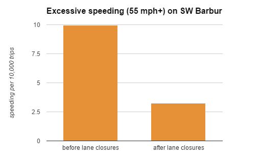
A few times each day on the wooded four-lane stretch of inner SW Barbur Boulevard, state data released last week suggest, someone decides to hit the gas and zoom through at an average 55 mph or more.
And about a dozen times each year, Barbur’s crash history suggests, someone on this part of Barbur loses control of their vehicle and hits something. Once or twice a year, someone dies.
Since narrowing the road in this stretch to one lane in each direction appears to make many fewer people choose to hit the gas, a redesign that would replace one of the northbound lanes with a bike lane and walking path in each direction could be seen as a perfect test case for Vision Zero. That’s the principle, endorsed by Portland’s transportation director, that safety is always a higher priority than convenience when it comes to road design.
But even if you don’t subscribe to that philosophy, a local traffic engineering analyst has sent us an interesting email making the case that redesigning Barbur would also pay off using the current U.S. system that estimates the economic cost of injuries and deaths.
Here’s the unabashedly back-of-the-envelope calculation from the analyst, Brian Davis of Lancaster Engineering (disclaimer: this the same firm that has sponsored BikePortland in the past and who we share our office with). He’s drawing on two figures:
- 68 seconds of additional average travel time on Tuesday, Wednesday and Thursday during the period when northbound Barbur is congested (7 a.m. to 9 p.m.)
- A 37 percent drop in collision rates observed on other Portland streets that were narrowed from four lanes to two plus a turn lane.
Advertisement
Here’s a lightly edited version of Davis’s email, explaining his calculations:
The 68-second figure is probably an overstatement (even given that, as you discussed, delays the other two weekdays will be much lower). The travel time between April (2 NB lanes) and June/July (1 lane steadily closed for construction) is only 12 seconds. It increases another 56 seconds during the October period, when you have “intermittent lane closures.” As ODOT states, “This is likely attributable to the combination of seasonal variation (school being in session) and a more intense construction period in which the lane closure configuration varied from day to day.”
Well, that’s a factual statement, but I’d bet it’s far more heavily the latter than the former. In Portland proper, we simply don’t see all that much seasonal variation. The decrease in traffic from school being out is more-or-less cancelled out by an increase in tourist and recreational activity. The construction there is mattering greatly.
Still, even using the 68 second figure, we get an annual loss to the regional economy of only $442,000 due to the increased congestion.
Assuming the system is below capacity the rest of the day and there’s no significant delay from the lane reduction as a consequence (I think that’s what the report implies), then the 3,000 vehicles travelling in the morning will each experience that but few other cars will be affected.
If I then assume an occupancy of 1.5 people/vehicle, the daily added delay from the lane reduction is 85 people-hours. So let’s assume a cost of the delay to be something like $20/person-hour. With 260 work days per year (and don’t forget, the delays will be lower by ODOTs estimation on Monday & Friday, so now we’re overstating things), that means the lane reduction (if the observed effects were permanent) would result in a loss of about $442,000 in productivity.
Davis is only counting the productivity costs in the northbound direction. If we assume that narrowing Barbur in both directions would create a similar delay for southbound traffic, we’d be up to $884,000 in lost productivity. But even that, Davis said, would be dwarfed by the economic advantages of a safer street.
I pulled the last five years of crash data for the affected segment of Barbur between Hamilton and Bertha. The data show that the road is every bit as deadly as we suspected, with 6 fatal crashes, another 62 injury crashes, and 53 non-injury crashes from 1/1/2009 to 12/31/2013. Using the 2009 Highway Safety Manual’s crash costs, I can calculate the annual cost of crashes along the segment to be $5,596,000.
The PBOT study that you wrote about a few weeks ago found a 37% reduction in crashes along road dieted segments. While I think this road diet would be pretty different in character, it certainly seems reasonable that we might see similar reductions in crash numbers and severity given that we saw speeds pretty significantly reduced. That would save a little over $2,000,000 each year in crash costs.
I asked Davis if it was really fair to assume a 37 percent reduction in crashes, since that figure was based on more urban streets in east-central Portland that have lots of intersections.
It’s a good question. Without considering the PBOT study findings, if we can say that if the road diet reduced crash frequencies and severity by at least 8%, then we’ve outweighed the cost of the additional delay. Certainly, we would exceed that.
So even from a cold actuarial perspective where time is money, lives have prices, and money talks, the road diet would represent an overall benefit to the region’s economy.
I’m sure this is only one of many ways to look at this problem, and it’s admittedly a pretty rough estimate. Even so, let’s put it on a chart:
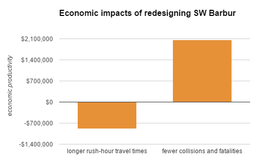
For a redesigned Barbur to not have economic benefits, these rough estimates would have to be pretty far off.


Thanks for reading.
BikePortland has served this community with independent community journalism since 2005. We rely on subscriptions from readers like you to survive. Your financial support is vital in keeping this valuable resource alive and well.
Please subscribe today to strengthen and expand our work.
Didn’t someone from PBOT tweet at one point that there was nothing they could do about speeding on Barbur? I remember people calling them out on that defeatist, and wrong attitude. Seems if you work for PBOT, you wouldn’t want to claim that a major part of your organization’s job description doesn’t do anything. Design makes a difference.
I think you’re thinking of ODOT, which wrote last year on its Twitter account that it was not sure how road design encourages speeding.
We really gave ODOT a proper tongue lashing for that poorly thought out tweet. So much so that Jonathan even wrote that story about it.
so what you’re saying is that ODOT is wasting everybody’s money and killing people when they delay these road changes…
We deliver coffee by bike and to clients in Sellwood and on the West side of the river. Having a fast safe route along this corridor might have additional economic benefit beyond what has already been discussed. It’s a car-centric view to not also consider the plus of additional bike traffic because the route is not only safe, but pleasant.
If Barbur truly is going to be safe for all, the bike lanes need to be separated cycle tracks or even the raised bike lanes a la Cully/SW Multnomah. Just paint on the ground isn’t enough for the Vision Zero goal.
i’ll take the paint for now.
As long as it’s clear that it’s just Step 1 in the process, and a clear timeline is spelled out for when a cycletrack would be installed.
Don’t take paint. Putting paint on the ground tends to be the only thing done here in the US. Basically whatever kind of infrastructure changes you get in favor of bicycles tend to be the last changes you get in favor of bicycles. “Here’s your infrastructure, now shut up.”
Speaking of economic impacts. A lot of focus is rightfully on the bridge death-traps. But of course it’d be odd to go from one northbound lane to three at the Capitol merge. The other piece of a potential road diet (north to Hamilton as has been suggested, but why not all the way to the Naito split??) could be big for economic development.
I live in the Barbur/Hamilton area, and going to 2 lanes each way with legit bike/transit facilities would be massive for the “neighborhood” I think. In quotes because maybe with such improvements there actually could be a real neighborhood there, with, of course, all the economic development that comes with it. I assume as a state highway that development on Barbur itself would be limited, but the neighborhoods surrounding it could really stand to gain.
Hype, that is, with reference to the road and the bridge being described below, respectively, as “deadly”, and “death-traps”:
“… A lot of focus is rightfully on the bridge death-traps. …” Gary
“…I pulled the last five years of crash data for the affected segment of Barbur between Hamilton and Bertha. The data show that the road is every bit as deadly as we suspected, with 6 fatal crashes, another 62 injury crashes, and 53 non-injury crashes from 1/1/2009 to 12/31/2013. …” brian davis/lancaster engeering, in comments to this bikeportland story.
Unless of course,data shows that the approaches to Barburs’ two bridges, not having bike lanes on the roadway across them, has been the cause of collisions, injuries and death to road users. Somebody besides Brian Davis, and bikeportland’s Michael Andersen, reading here, must have looked at the data, to know whether any of those collisions, injuries and deaths occurred on, or say, within a hundred feet of the bridges.
It may turn out that the road diet could get at least a trial run on
Barbur, but trying to sell people a load of hype to get them to support the road diet could spoil chances of that happening.
This is my “hood” and I will definitely be paying attention and involved in the out come of this possible project!
I think we need to push hard to have them recognize this is not a “bike lane” situation it should be a fully separated path with more than just a raised curb type path!
then my other concern is what will they do at the Capitol Hwy intersection? whether it is a bike path or lane they will need to confront the heavy interaction between bikes and cars turning to go up Capitol hwy… right now the speed for that turn is 30mph and most drivers do it faster.
the only true solution is to do an over pass for cars and under pass for a bike path with an option for bikes to go up capitol hwy…which is also a complete nightmare to ride in that bike lane!
I won’t ride barbur to capitol hwy now because it is just to dangerous, I take Broadway to Terwilliger which is the lesser of two evils as it is!
I will definitely be on the edge of my seat and involved with this as much as possible!
I recall a group of modern roundabouts to reorganize the area. Low speed intersections, like modern roundabouts, are much more friendly to cyclists and pedestrians.
it’s an advisory 20 MPH…
but yes, people are going much faster than that… faster than is safe because they’re driving beyond their visibility around that blind corner…
When riding or driving on Barbur I’m often struck with the thought that, if it were a mere city street with regular traffic speeds, much of the land, particularly downslope, would become attractive to developers.
This is even more true if the city could somehow annex the east-most lane and shoulder — that’s like 20+ feet of flat, buildable surface x 1.2mi — which is what, 50 half-size city lots? Each with a Mt. Hood view. Talk about an economic win…
Or it would be a kickass linear park, something like what we have along Terwilliger. That would dovetail nicely with the Red Electric/Slavin Road trail the SW Trails folks have been working on for so long.
So much potentially useful land going to no use at all, except as a (theoretical) shortcut for people commuting by car from a sliver of SW Portland (I admit I’m one of those people).
Barbur bugs me on so many levels: as a driver, cyclist, neighbor, taxpayer.
“…buildable surface x 1.2mi — which is what, 50 half-size city lots? Each with a Mt. Hood view. …” souders
There goes the view for people using the road. Not enthused. The obsession with acquiring view property to construct above grade buildings on, has blocked many a view for people out to enjoy the view as they ride, walk, or drive. Vista Ave, Skyline Blvd, and gradually on Fairmont Blvd.
I’d rather driving people were watching the road and not the view… they can pull over to a vista viewing area if they wish…
the slow ped/bike people already have plenty to look at with their slow pace and can look between the buildings at the view as they pass…
“…the slow ped/bike people already have plenty to look at with their slow pace and can look between the buildings at the view as they pass…” spiffy
You say that looking between buildings at the view would be just wonderful. Wall off another of Portland’s scenic view routes, to make some more money, no problem. Corbett is another street nearby where in the last six or seven years, the city permitted construction of a huge, connected apartment complex, replacing existing buildings that between them, afforded some view out over the river and beyond. The new complex blocked out even the limited view between buildings.
The view out over the city, the river, and the scenery beyond, is one of the best possible incentives to have people slow down. A willingness to discard the scenic view with the idea that doing so will somehow have people driving, watch the road more, is not commendable. Almost certainly, the scenic view this road affords at points along it, has not been the cause of collisions on the road.
PJ, I saw your suggestion to retain the scenic viewpoints, and think it’s important to do that. The city most likely can find some slivers of land elsewhere to meet growth needs and make money.
I’m actually with you, wsbob, I was making a point about the economic impact to the city of having approx 1mi of lightly-used state highway running through some of its most desirable views. Personally I’d rather see a Terwilliger-style linear park along Barbur.
SW Trails has had some positive news lately about the bridges for the Red Electric Trail.
This is a dangerous line of thinking guys. Taken to it’s extreme, our streets will all become calm, safe places, lined by economically prosperous businesses and surrounded by healthy households rich with transportation options.
ODOT’s worst nightmare, apparently.
Don’t worry: thousands of people will be put out of work in the industries of auto body repair, towing, auto insurance claims processing, automobile sales, ambulance services, EMS and emergency rooms when our streets are safe.
.
If you want to start a productive rumor tell your friendly r1ight wing conspiracy nut that UNsafe streets are a plot to redistribute the income of hard working Americans to (whomever) by making using roads so unsafe that collision and hospital costs are guaranteed.
You might also wanted to consider the travel time cost for trucks, which is $86.81/hour based on TTI’s Urban Mobility Report for the PDX Metro. Then apply the truck percentage on Barbur.
Regardless, I bet the numbers will still result in an overall economic benefit if improvements are made to Barbur 🙂
Regardless, I bet a human life is worth more than the cost to transport goods.
Yes, there is a standard $value for a human life, and if they can cut the number of deaths in half then they need to include that on the benefit side of the equation.
If it reduces SOVs, you also have to account for reduced delays in rush hour and increased fuel economy from steadier traffic flow. And the bus would run on time.
Nobody has mentioned the overgrowth of invasive plants all along this corridor and into the park (erosion, runoff, sign/lane maintenance, trees falling on the road…)
There’s probably no data—‘cuz, who cares—but I wonder what the time savings would be for people traveling by bike who would use a safer Barbur instead of some longer, hillier route to get to/from town?
Also, we should be careful with these kinds of calculations of economic impact; Anyone who decides to quit driving on Barbur and starts riding instead is dragging down the economy with all that lost productivity (assuming riding would be slower than even driving at 24 mph).
These were also my thoughts when we were arguing about the road diet’s implications for future travel times on Foster. Cora Potter et al. were up in arms about the aggregated, hypothesized delays for those in cars, but no one was tallying the time benefits for people not in cars, who can now (when it is done) use Foster in a manner they might not be comfortable doing today.
As Zaphod said above, more bias when all we’re counting is the changes the car bound are experiencing.
I don’t dispute the positive impacts, but the negatives ($20/hr? really?) are probably understated enough to convince me of a net effect closer to zero.
Making several trips a day, a plumber/locksmith on that corridor may have to drop one (not-inexpensive) appointment from their day or work longer hours. A truck with a crew is even more unproductive labor. The freight or machinery they carry is idle capital. It isn’t about OLive cranks who drive downtown from Tigard, it’s the livelihood of working people.
Even with that perspective, we can’t just shrug our shoulders when people are injured or killed. What are the higher-priority projects kicking this SW Corridor can down the road? What will this project even look like after every suburb assumes veto power?
You can assume any values you like, including some estimate of truck traffic as Jesse described above, but the $20/hour is actually rather conservative. FHWA methodology** ascribes a value of $11.89 per person-hour to local, intra-city travel, which is what the vast majority of NB travel during the morning peak hour will be (people commuting to work, basically…this is considered personal travel).
You can assume some percentage of trucks at a higher rate, and some percentage of business travel at the FHWA’s rate of $29.75 per person-hour, but I’d bet your average is something close to $20/hour, which is a common rule-of-thumb estimate.
** Link (see section 2.2.2) http://ops.fhwa.dot.gov/wz/resources/publications/fhwahop12005/sec2.htm
The current delay in the SW Corridor Plan is due to Tigard and Tualatin ballot measures that now require a vote on any high capacity transit. The planning committee has begun an 18 month reset to figure out what to do about them. Following that – assuming Tigard/Tualatin agrees to HCT – there will be a lengthy environmental impact study. Then, assuming there is funding, construction can begin. So, I wouldn’t expect anything significant happening from that project for, oh, 10-20 years.
The Powell/Division HCT will be fully implemented and SW will still be talking about it.
“Making several trips a day, a plumber/locksmith on that corridor may have to drop one (not-inexpensive) appointment from their day or work longer hours. ”
Several trips a day, even assuming they were all during the rush hour when travel times occasionally might increase by a minute, would hardly equal a service call/appointment. Can you elaborate on your math, Champs? I get ~six extra minutes for three trips, and that would be generous since it is nearly impossible for them all to be during the rush hour period we’re talking about.
And what about the bicycle plumbers & locksmiths? Don’t they count? I’ll bet their time saved would be greater than their van-bound equivalents.
makes cents to me!
Interesting analysis and some good ideas to think about. I suspect the economic benefits would go far beyond this, however, just by increasing the livability and, consequently, the value of properties. If people are comfortable biking and walking in an area, I imagine local businesses would profit, as well. And there are the economic benefits of increased biking and walking to healthcare, road maintenance, etc…
That Fred’s does have comically underused bike parking
There is no bike lane or even a walkable shoulder between SW 19th and SW 17th Ave on the northbound part of Barbur. This is right by two big schools and the new Safeway which wasn’t built with bike lanes on SW Capitol Hill Road.
The future Red Electric Trail is greatly needed.
The strength of this bikeportland story’s bean counting exercise is debatable. Attempting to use long term, hypothetical cost analysis benefits to leverage approval of plans to reconfigure and reduce the number of Barburs’ main lanes, is a less effective strategy than looking simply at negative aspects arising from how this road has come to be used, and doing something about that.
On condition that money is in hand to reverse the configuration if it doesn’t pan out within six months or a year of its debut, give the road diet an actual trial run. Personally, I have doubts that taking out one of the road’s main lanes will much slow down the late night speed freaks that push the pedal to the metal and lose control of their car. Taking the main lane out to create room on the road for bike lanes allowing a continuous transition past the roads two bridges, would offer some improvement for biking though.
A speed between twenty to thirty miles an hour, is all the faster anyone should need to travel, regardless of their mode of transportation, except emergency vehicles, on the section of Barbur Blvd between Terwilliger, and where the road flattens out before entering town. Better, more effective ways of keeping speeds traveled, consistently down to somewhere within the aforementioned speed range likely will be required, if that truly is one of the objectives people seek for this road.
And that is one of the demonstrated benefits of road diets, the reduction in speeds along the route.