(Photos: M.Andersen/BikePortland)
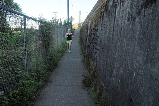
A 0.7-mile bike detour between Willamette Park and the west landing of the Sellwood Bridge that steers people from a riverside trail to an unbuffered sidewalk along a four-lane state highway will probably stick around until late 2015, county communications show.
But at least the route, which includes several long street-facing curb cuts, a narrow dip into a ditch and various lightposts in the middle of the sidewalk, may not stay in use as long as project managers had until recently planned, thanks to pressure from biking and walking advocates.
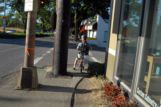
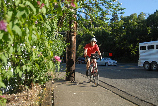
Here’s the route, which takes people up from the riverside path onto the east sidewalk of Macadam.
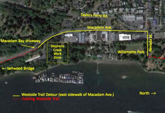
As costs piled up on its $308 million Sellwood Bridge project, Multnomah County decided this spring to save $70,000 by scrapping plans for a temporary walking and biking bridge across Stephens Creek, just north of the bridge landing on the west bank of the Willamette River. As the county noted in its explanation for the decision, the 70-foot-long bridge would have required environmental permits for in-water work and been in use for only three to six months.
The catch, however, is that the new path between Waterfront Park and the bridge (which will, it’s worth noting, be awesome) won’t be built until 2016. The beautiful, bike-friendly new Sellwood Bridge will open in late 2015.
As Bicycle Transportation Alliance advocate Carl Larson put it, “Picture the grand opening of the new Sellwood Bridge: throngs of people walking and biking, excited to cross the new bridge, only to be dumped onto this.”

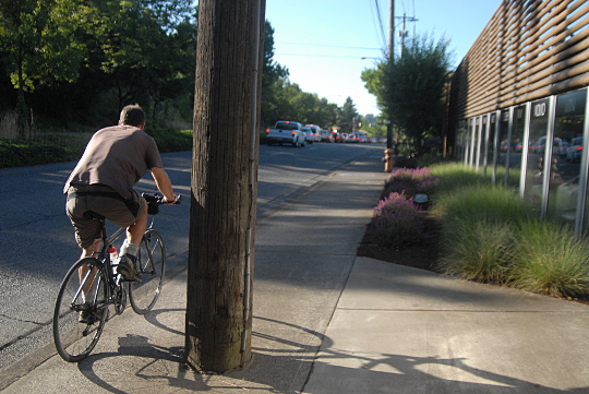
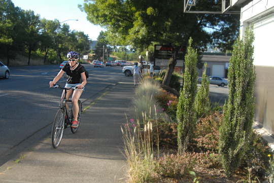
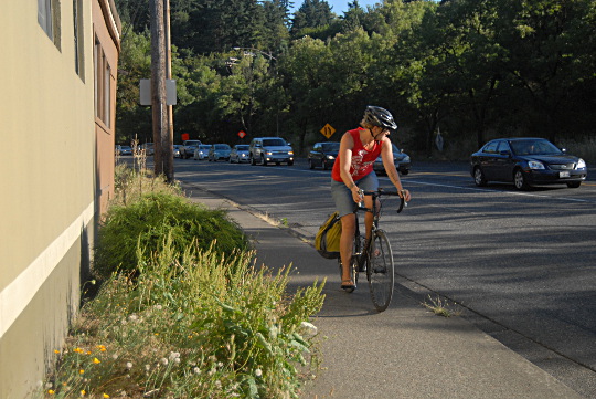
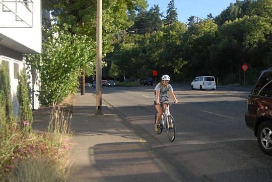
Embarrassing photo ops aside, the detour is a daily route for many bicycle riders (as you might recall from our ride-along with a Sellwood family back in May), and will continue to be for at least another year, maybe two. Note that each of the photos below comes from a different point along the route, with bike traffic headed in both directions. They’re from between 6:10 and 6:40 p.m. on Thursday.
Advertisement

Larson and members of the Multnomah County Bicycle and Pedestrian Advisory Committee have been pushing for, if not a temporary bridge, some other solution that will end the detour sooner.
According to a letter from Sellwood Bridge Project spokesman Mike Pullen, forwarded by Larson, committee members floated these ideas (emphasis mine):
- Converting a northbound lane of Hwy. 43 to a bike lane
- Narrowing the two northbound lanes of Hwy. 43 to create a bike lane
- Widening the sidewalk
- Add zebra crosswalk striping in driveway
- Shift detour route to haul road
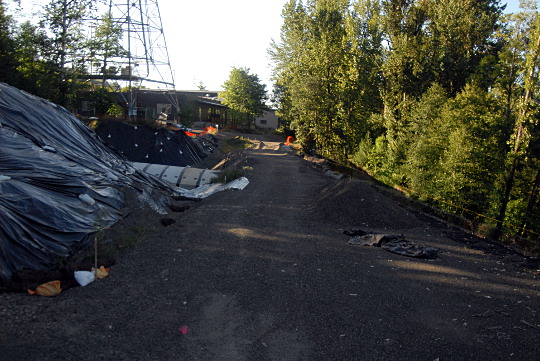
The vehicle traffic counts and merge zones on Hwy. 43 [editor’s note: Macadam] eliminated the first three suggestions. PBOT recommended re-striping the stop line in the driveway instead of the zebra stripes.The committee’s suggestion to shift the detour route onto the haul road/new regional trail as soon as possible does have support from PBOT and the project team. We are working on a plan to shift the detour onto the new regional trail as soon as the new bridge opens in late 2015. The bridge that will carry the trail under the west end of the new bridge will not be completed in 2015, but we do think it is possible to open the trail to the north of the bridge at that time.
Here’s the “haul road” that will presumably become the future regional trail, currently in gravel and fenced off at both ends. The metal culvert visible at left carries Stephens Creek into the Willamette.
Until this connection opens, be it in 2015 or 2016, don’t expect the comparatively tiny number of Portlanders who use bikes to get between Southwest Portland and the rest of the city to change. Here’s the best news for people on bikes, though: after it does, they probably won’t have to roll on this sidewalk again. People in wheelchairs won’t be so lucky.
 one hotel on Broadway that embraces the bike lane and those who use it")


Thanks for reading.
BikePortland has served this community with independent community journalism since 2005. We rely on subscriptions from readers like you to survive. Your financial support is vital in keeping this valuable resource alive and well.
Please subscribe today to strengthen and expand our work.
$70,000 seems a drop in the $308 million dollar bucket, (my math isn’t what it should be…%3 or so?) *and correct me if i’m wrong, but aren’t there allowances for how much of a roadway project budget is allotted for bike/ped ‘in-line’ construction? Like rules/law that demands it? This is the epitome of ‘let them take what we give them and like it’ mentality. The bridge over Stephen’s Creek and safe bike/ped access to the Sellwood itself and beyond should have been the first things done. If automobile drivers had to withstand the dangerous and limited access we as ‘other than auto’ users have had to because of this project, i’m sure by now it would have made the front page of every local paper and t.v. news broadcast…but whatever, we’re just menial ol’ bike riders….what difference does safe, convenient access matter? When two riders have to cross on the narrow shared sidewalk and one dumps onto the road and gets squished or someone clips one of those poles and the same things happen, i hope every contractor, city agency and O.D.O.T. gets sued right the hell out of business.
70,000/308,000,000 x 100 = 0.023%
thanks…
70,000 / 308,000,000 = 0.00023 = 0.023%
(23 parts per 100,000, or a little over two hundredths of one percent)
I would rather spend $70k on some permanent bike infrastructure instead of a 3 month band-aid. I know the budgeting doesn’t work that way, but it is a lot of money to spend for a temporary facility.
As I understand it from this article, and maybe I’m wrong or maybe there’s more to it, but the new Sellwood Bridge won’t open until late 2015 and the Waterfront Park and bridge, which will be the bike route to replace the terrible conditions shown, won’t open until 2016. Now, it’s also not clear whether the EIS are on top of the $70k, but either way, amortizing that out over a year and a half and comparing the mortality risks of the present route and that money sure starts to look cheap compared to human life.
Would the DOT assume an equal probability of a motorist’s death for that price?
Like this?
Interesting that if drivers who drive too fast are consistently crashing, it must be a roadway defect. If cyclists (or pedestrians) consistently have crashes (non-auto-involved) or close calls in a location, it’s because they’re stupid to travel there or weren’t being careful. I’m reminded of the MAX/Streetcar track “discussion”, the result of which is “cyclists: be more careful or don’t ride there”. Meanwhile, drivers that crash on an unfriendly piece of roadway sue the State DOT. It almost seems like we think that the DOT “owes” drivers smooth and safe travel, but has no such obligation to cyclists or pedestrians.
My son and I took this route almost every day on our way to school this past year. It’s super hair raising with a trailer or tagalong — too narrow for two-way traffic at many points. The traffic lights at the cemetery are also poorly planned & leave dangerously little space for folks waiting at the SE corner between signals. (With better planning this could have been a single crossing signal, I’m baffled that no one on the planning team realized this). Altogether it’s clear that non-motorized traffic on the west end of the bridge is an afterthought at best. I have the same thought as Jolly Dodger, that if motorized traffic had to endure something so janky and dangerous … well no one would tolerate it for even a single day.
Also, the “official” detour on the Macadam sidewalk is much longer than necessary. If you’re going North you can turn right/east onto Miles St. and then left/north on Miles Pl. to reach the south end of Willamette Park. You can even cut through the (gravel) parking lot between Autowerks and the kids backyard store/Gorge Performance, which bypasses the curb hop & stoplight at Taylors Fy. (This shortcut was suggested to me by an employee of one of those businesses BTW)
This is crazy, that detour is something out of a third world country, and 70k is TWO HUNDREDTHS OF ONE PERCENT of the 308 mil.
Who can I contact / pressure to have them open the gates to the gravel haul road and just let us ride on that?
Ugly as these pictures look, the takeaway from this article is encouraging: the county will have a vastly-improved detour in place in time for the new bridge opening (maybe even sooner?). Phew!
Forget about bikes, those sidewalks aren’t even ADA compliant… How the hell is a wheel chair or a walker supposed to get through there?
^”other than auto users”…my point exactly!
it is terrible, terrible, terrible and awful. many thanks to Larson and members of the Multnomah County Bicycle and Pedestrian Advisory Committee if they can do anything to relieve the difficulty through there.
Not only bikes, pedestrians have a horrible time here.
But don’t enforce the cars going 15-20 mph over the limit with 4 lanes rushing to the red lights at Taylor’s Ferry. Not a priority at all.
Anyone know why they don’t install a traffic Circle at the West end of the Sellwood? That right there is a perfect location for one…
I would guess a combination of not having any modern traffic circles as of yet and the constrained space. A significant cost of the project is a massive retaining wall and hillside stabilization project. The west end is part of a giant slide that has been moving since the end of the ice age.
There are actually modern traffic circles in SW by Lewis & Clark College.
https://maps.google.com/?ll=45.452815,-122.676584&spn=0.000853,0.001206&t=h&z=20
Modern Roundabout.
The FHWA has a video about modern roundabouts that is mostly accurate (http://tinyurl.com/6v44a3x).
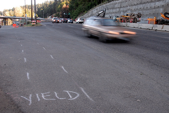
The detour is dreadful, but your contention that there is no motor vehicle speed enforcement is wrong. Motor officers have been ticketing speeding cars with frequency and zeal, and vans with radar have also been ticketing speeders. This is not so much because bicycle riders are second class citizens, but because project workers are in VERY dangerous conditions.
I see the motorcycle officer(s) there ever once in a while, and I am very appreciative ( I wish I had a way to communicate my appreciation to them while they’re less busy ), but it’s not nearly enough. I wish I saw one every day. Today I saw someone who thought it would be appropriate to blow through that construction zone at nearly 45mph. That would have been such an enormous ticket had the officer seen it. Wouldn’t a little extra enforcement pay for itself?
Macadam is such a shitty street… thanks for writing this article to expose its horrors!
The greenway on the west bank of the river is a viable alternative. It is old, heaved by roots, narrow by multi-use trail standards, trafficed by dog walkers and pedestrians and it is rather curvy, but there is no traffic or noise and I always delight in riding right next to the river. Seeing an eagle is not uncommon.
I’ll wait until I read about the opening of the new bridge/parh until I head to the west side of the river again….riding under the Sellwotd is scary enough not even talking about tne detour. That narrow sidewalk next to the cement barrier has been the route since the beginning of time it seems….or at least the 50’s…..
What?! I’ve been assuming all along that once the new Sellwood Bridge opened up, that unbelievably crappy detour (which I ride about once a week, on average) would finally be gone. I can’t believe they were even THINKING about not opening up the haul road/new path until the following year. Sheesh.
By the way, I haven’t measured, but I think that spot shown in the top photo must qualify as the narrowest paved sidewalk in the city. It is no more than 8 inches wide. Based on sidewalk work I’ve had done in front of my own home, I’d estimate that some of that gravel could have been replaced with concrete for about $308. That is, about 0.0001% of the total budget.
I run and bike this regularly, and the detour route is appalling.
There was an elderly gentleman biking ahead of me, who was clearly very nervous to be on his bike on this stretch. It is so narrow in places, I worry if my bike will fit between the streetlights and stop sign poles that litter the sidewalk. Every twenty feet, he had to stop his bike, nervously get off, and walk his bike through the narrow sections. Which is to say – most of it.
Oh! And let’s talk all about the sidewalk shall we! All THREE FEET WIDTH of it!
If you meet somebody coming the other way on the detour, you are screwed.
It’s just awful. I can’t believe I have to wait until 2016 for somebody to get off their ass and fix this.
Just curious, does anyone know when Macadam was built in its current configuration – 4 lanes and too-narrow sidewalks? Wasn’t it back in the 1980s?
I take this route every day commuting to work. While not ideal by any means, that still doesn’t give bikers an excuse to ride in a way that endangers others. I often see near misses and sometimes even collisions between bikers and pedestrians. My plea to anyone taking this detour path is to slow down and yield often. If you can’t pass the slow walker or biker in front of you safely, don’t. Just plan for the fact that it may take you that extra two minutes, which is less than the motorized traffic regularly encounters during construction.
Is there something wrong with the multi-lane road that prevents cyclists from using it instead of the sidewalk?
There’s rarely anything wrong with the road, I think it is fear of driver behavior on a road that prevents cyclists from using it. If this stretch is posted at 35 (I don’t know, I haven’t ridden or driven here, just looked at the online maps), and drivers here are like drivers other places (where I do ride), then 50 mph would not be an uncommon speed, and passing within the narrow lane would likely be a frequently attempted stunt. Taking a lane here (to prevent unsafe passing) would likely draw the ire of so many motorists, who would be tempted to (and likely would) act out in aggressive ways, that most bicyclists would be intimidated right back onto the sidewalk. Besides, haven’t we been assured that the sidewalk is “safe”?
My girl is still hurting (months later) from a sign that blew over (it had been placed in the bike lane) just past OMSI.
It was a warning sign from the contractor that the bridge would be closed. They are in the process of total denial that they had any fault, and attempting to get her to agree to that. This of course will not do.
If anyone else has had problems with the signage or detours, or anything caused by the Sellwood bridge construction please contact me. The only way to make it really safe is to show how truly unsafe the scenario is now, and has been.
Also, riding directly on Macadam in the area this article speaks of is safer than using the sidewalk, or even the path.
For contrast, see http://bikeportland.org/2014/07/16/bikeped-belong-question-states-funding-bike-projects-108871
“How does a bike/ped project displace a project that benefits multiple regions and benefits numerous businesses? Bike/ped does not belong.”
“There is real concern about spending scarce transportations dollars on bike paths,” said another unsigned comment.
In the first picture I see two power poles. The closer one looks old/faded and the farther one looks new/brown. It would be good to know if/when the old pole will be removed, since it is a violation of the Americans with Disability Act that requires 3-4 ft of clear path.
It also seems to me that IF they had closed the bridge during contruction, they could have saved some construction money and repurposed the northbound curb lane for bike use. There are lots of alternative ways northbound into Portland from the south.