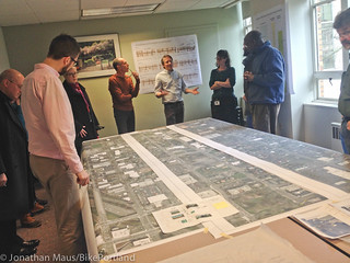
committee members answered questions
at their Tuesday meeting.
(Photo by J. Maus/BikePortland)
If all goes according to plan, your experience riding north on N Williams Avenue will be much different by the end of this summer. After a long and winding public process, PBOT is close to finalizing a design and going to construction on a significant re-design of Williams Ave between Weidler and Killingsworth. At a meeting Tuesday, city staff and members of the project’s stakeholder advisory committee shared details and answered questions on both the Williams project and a companion project that emerged as a priority during the public process — a neighborhood greenway on N Rodney.
As we’ve covered recently, there are two basic cross-sections PBOT will deploy on the 40-feet of right-of-way available on Williams.
For most of the length of this project, the new design for Williams comes with a generously-sized bikeway on the left side of the street, one standard vehicle lane (there used to be two), two lanes for on-street parking, and several upgrades like a new traffic signal (at Cook) and new curb extensions and crosswalks. Specifically, the dominant cross-section will be an eight-foot parking lane, then a 12-foot bicycle lane (which consists of a three-foot buffer for car doors, then a seven-foot bike lane, then another two-foot buffer to the adjacent lane), then a 12-foot standard vehicle lane, then another eight-foot lane for auto parking.
To put it another way: Of the total 40 feet, 16 feet will be dedicated to parking cars, 12 feet is set aside solely for the operation of bicycles, and 12 feet will be used (mostly) by cars, trucks and buses.
Here’s a visual I mocked up using Streetmix:
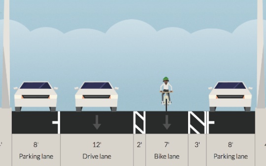
Compared to the current five-six foot bike lane that exists now, the new design will make for a more pleasant riding experience — even if it’s not the curbside, protected cycle-track some hoped for at the outset of this process.
However, in the blocks of Williams with the most restaurants, housing, and other destinations, PBOT drops the one bike lane/one standard lane configuration in favor of two standard lanes and no bike lane. PBOT’s rationale (a.k.a. what the national level-of-service guidelines tell them) is that two standard lanes are needed in this section in order to maintain expected auto capacity. This change begins between N Fargo and Cook, just south of the new New Seasons Market. North of Fremont, the bike lane buffer is removed, then north of Beech, the bike lane is gone completely and all that’s left is a sharrow marking. This shared environment continues for about four blocks (until N. Skidmore Ave.).
Here’s how that shared environment will look:
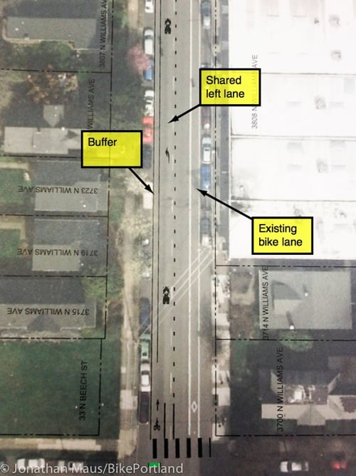
At first this design had me very concerned. I felt it was another example of PBOT bowing to outdated, auto-centric level of service guidelines (which many feel should be repealed entirely). But upon further examination and discussion with PBOT staff at the meeting, I’m a little more positive about the design. Here’s why: Yes, these 3-4 blocks through the busiest, most interesting section of Williams will not have dedicated space for bicycling and people on bikes will be in a shared environment with people driving cars. And yes, PBOT’s design was influenced by auto capacity standards that run counter to every planning goal we’ve adopted; but there are reasons to expect (and hope) that the left (shared) lane will be primarily for cycling traffic and will be only sparingly used by drivers.
Several PBOT engineering staffers at Tuesday’s meeting said they will try to use signage, pavement markings, and other design cues to clarify that people driving cars should only be in the left lane if they intend to park or turn left.
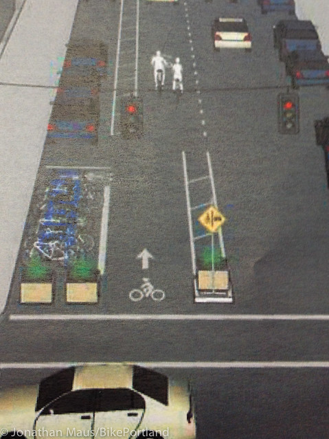
At the start of each block in these shared-lane sections, there will be some sort of median similar to what’s shown in the mock-up below…
This physical infrastructure (it will be either a paved and/or planted median) should provide a strong visual cue that the space beyond it is not a standard lane. PBOT is still finalizing exactly how to “beef up the look of that throat” (in the words of one engineer), so if you have ideas, feel free to share them. There will also be sharrow pavement markings and some sort of signage to drive the point home. It’s also worth noting that the left lane in the two-lane sections is a left-turn only lane. In other words, while technically it’s a second lane that you can drive on, PBOT says they’ll do whatever they can (design-wise) to limit auto traffic in the left lane.
While I’m hopeful the design will work, just how people behave in this busy four-block section remains one of the largest and most important unanswered questions of this entire project. If people drive dangerously and inconsiderately in this section it could vastly undermine the central goal of the project — which is to improve safety. Given the dense land-use, the left-turn only stipulation and design cues, I hope/expect auto traffic will be very light and tame in these sections — but we’ll have to wait and see how people behave in real life.
Another thing to keep in mind is that there are hundreds of new residential units and thousands of square feet of retail frontage being built/planned in this section (near Skidmore), so it’s absolutely crucial that we get the street environment right.
And this design could have ramifications for how PBOT handles bike traffic in other dense commercial districts. Thus far, they have been very reluctant to use shared-lane markings (a.k.a. sharrows) outside the safe confines of neighborhood greenways. Sharrows on busy streets, the thinking at PBOT goes, could send the wrong message to families and novice riders who expect them to symbolize low-stress conditions. Putting sharrows on a major road like Williams is a big step for PBOT and — if it goes well — could influence other projects in the future.
One last thought (for now) about the new look of Williams is that left-side bike lanes are new to Portland. This will be one of the busiest bike streets in the city with one of the most unique engineering treatments. That could lead to chaos until folks get used to it. Stay tuned.
Speaking of chaos, the crazy traffic situation on Williams is what spurred PBOT’s plans for a neighborhood greenway on Rodney, a north-south street just a few blocks to the east. On Tuesday, PBOT shared its plans for Rodney for the first time.
Once the project is complete, Rodney will have the same features — speed bumps, bike network wayfinding signage, 20 mph speed limit, and sharrows — that we’ve come to expect on neighborhood greenways. In addition to those standard elements, six intersections will get special attention: Russell, Fremont, Shaver, Skidmore, Alberta, and Killingsworth.
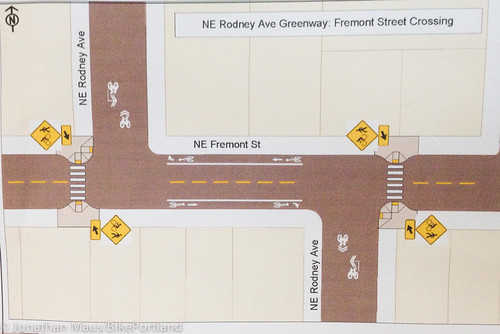
The most significant crossing treatment will happen at Fremont, where PBOT must grapple with a tricky off-set intersection. They’re currently looking at two options: adding curb extensions, bike lanes (on Fremont) and a new crosswalk;
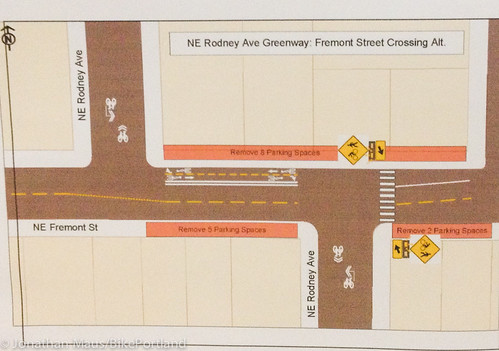
or adding a flashing beacon and a two-way cycle-track on the north side of the street (similar to the Going/33rd intersection).
According to project manager Rich Newlands, there will be an open house in April to garner more public input on the Rodney plans.
Both the Williams and Rodney projects are funded and are expected to be fully completed by the end of this summer.
We’ll have more coverage as plans and construction timelines become finalized.




Thanks for reading.
BikePortland has served this community with independent community journalism since 2005. We rely on subscriptions from readers like you to survive. Your financial support is vital in keeping this valuable resource alive and well.
Please subscribe today to strengthen and expand our work.
And then years later, people will say: why didn’t we just do what Copenhagen did?
In the third paragraph you reference a “then a 12-foot bicycle lane”. I think you mean “drive lane”. Right after that, you mention the “(which consists of a three-foot buffer for car doors”, which should go with your mention of the 7 foot bike lane.
browse,
Thanks, but I think I have it right. I’m trying to say that the bike lane is 12 feet wide and that it is made up of a 3-foot buffer, a seven foot riding area, and another 2 foot buffer. Does that make it more clear?
Yep, I think I was trying to match the text to the graphic, looking at the lanes from left to right. When I looked at the lanes graphic from right to left, and read your parenthesis more carefully, you have it right. Sorry for the confusion.
That clears it up! I saw “seven-foot” buffered bike lane in a previous story and thought that was the entire lane width including the buffers. I take back what I said in the previous story about this being a door-zone facility. It is wide enough and has a wide enough door-zone buffer that I think it’s reasonable to call it a “door-side” bike lane like Nick Falbo was saying. I feel way better about this project now!
So what I, and what most other people, get from this is:
1. PBOT again puts parking curbside instead of creating a protected cycletrack
2. PBOT decides to completely leave out a bike lane where there once was one
anyone who believes that transportation planners in the netherlands and denmark would propose a cycle track “protected” by a buffer of parked cars is uninformed.
1) in the netherlands this type of infrastructure was discarded as unsafe a very long time ago. (see hembrow’s blog for more details)
2) safety studies commissioned by danish transportation authorities have reported that this type of infrastructure is less safe than facilities protected by a median or curb. building this type of facility is now discouraged in denmark.
example of a danish cycle track (the kind often built on busier arterials):
http://ramblershighway.files.wordpress.com/2010/10/dsc06020.jpg
close up of the very gentle curb or barrier that is typical for danish cycle tracks:
http://ramblershighway.files.wordpress.com/2010/10/dsc05972.jpg
http://ramblershighway.files.wordpress.com/2010/10/dsc06089.jpg
I actually didn’t mention either Denmark or The Netherlands in my post…kind of confused about what you’re referring to. In any case, I’ve biked around Denmark quite a bit and have a good understanding of how their infrastructure works.
My main point is that whatever you want to call the new configuration, newer, less confident riders will probably look at this design and their takeaway will be that for 4 blocks, they don’t even have a bike lane at all. I don’t see this as a way to appeal to the 8-80 crowd or increase ridership. But it doesn’t seem like that’s what PBOT was going for.
i mentioned denmark and the netherlands because i think it’s important to learn from the mistakes they made. and i doubt you will find many people in these nations who are supporters of parking-protected bike lanes.
“newer, less confident riders will probably look at this design and their takeaway will be that for 4 blocks, they don’t even have a bike lane at all. I don’t see this as a way to appeal to the 8-80 crowd or increase ridership.”
it sounds to me like you prefer this type of infrastructure and are simply assuming that the “interested but concerned” would agree.
interestingly, jennifer dill recently polled the “interested but concerned” and found that there was little difference in their perception of a standard door zone bike lane and a protected bike lane. this result makes one wonder whether buffered bike lanes might even score higher than protected bike lanes.
http://docs.trb.org/prp/13-5213.pdf
Figure 2.
I too lament the loss of the protected cycletrack, however this idea was tossed aside a while back in the process… Given this is a catalyst project that will indeed influence other busy commercial corridor projects, it would have been nice to see something a little more radical (protected cycletrack) developed the first time out.
One can only hope that in the future, the new plan of the buffered bicycle lane will be retrofitted to continue all the way through.
“One last thought (for now) about the new look of Williams is that left-side bike lanes are new to Portland. This will be one of the busiest bike streets in the city with one of the most unique engineering treatments. That could lead to chaos until folks get used to it.”
I won’t get used to it – my helmet mirror is on my left side. A left-side bike lane renders that useless. I feel less comfortable not knowing who’s immediately behind me, and who’s approaching me in the adjacent lane.
This is nice, but I’ll probably just take N Rodney instead. It’ll take a few extra minutes, but I don’t ride a bike to get around quickly.
At first blush I thought this whole restructuring would be a mess. However, now that I see how it flows I really like it. I especially like the filtering down of the bike lane to a left hand lane that is shared. With the bike traffic as it is there, that lane will fill up with bikes, and if you happen to be going alone in there at some time, you can leisurely just take the lane.
Are there changes to this at bus stops, or will the bike lane and a long load/unload cycle on the 4 completely halt the movement of cars?
bike lane moving to the left – that might have been unclear
I think that’s his point. There’s only one lane of car travel (for most of Williams) now and if a bus stops in the lane, will it impede travel for all the cars.
Answer: provided the bus driver pulls into the bus stop (just like they usually do now) then the answer is NO they will not block car travel, but more importantly bikes and buses will no longer play a dangerous game of leapfrog.
This post helps me a lot, in understanding the plans for Williams.
Is there a plan afoot for Vancouver Ave, the southbound partner to Williams?
This has probably been discussed quite a bit, but what was the rationale/preference for a left-side bike lane? (Reducing the potential for right hooks, I’m guessing?) If one of the goals is to have bikers stop and engage with the businesses on Williams, a lot of them are on the right (East) side of the street…
Steve,
There were several reasons the left side bike lane emerged as the winning design. Bus leapfrogging on the right is a huge problem and unfortunately TriMet wasn’t very flexible in allowing various solutions to happen. They essentially killed any right-side design by mandating large bus stop islands that PBOT couldn’t afford. Once it became clear that dealing with TriMet would be difficult and expensive, the left side became very appealing. Of course this is just my recollection, perhaps someone on the SAC can add more.
This design is very similar to 8th and (9th? or 7th…can’t remember) Avenues in lower Manhattan. They work fairly successfully in my experience, I found that left turning cars primarily yielded.
Great explanation Jonathan! I share your optimism about this plan overall, and I have some real reservations about the disappearing bike lane. As a precedent, look at Interstate ave between Killingsworth and Rosa Parks. There is space for a bike lane through the corridor, but they did paint one for similar reasons given for not including it on Williams. The result is sometimes ok from a cycling perspective, and frequently terrifying! I have honked and swerved at by car drivers while biking through here with my kid in a trailer! The sharrows may help, but I fear that the “end of the bike lane” will imply to motorists that bikes do not belong and provide justification for appalling behavior that I see routinely on Interstate. However, if this sharrow treatment gets adopted, I hope it paves the way (no pun intended) for using these markings to increase safety for places like Interstate Ave or Hawthorne.
I have concerns/issues with the shared lane as well. I understand the logic of it from a design standpoint, but mostly what I’ve seen on Williams is dangerous behavior exhibited behind the wheel of cars. Many people travel Williams at 5-10 MPH above the posted speed limit. Where I live on Williams, it is sometimes 15 MPH above.
When it’s evening commute time (northbound), I think there are enough cyclists to fill the left lane that they’ll be a force to be reckoned with. However, when there is less cycle traffic (outside of the commute time), then I think conflicts between cyclists and motorist are not only possible, they are inevitable.
I think the medians will help send a message if drivers are paying any attention. On the other hand, I don’t think sharrows do that much simply by virtue of motor vehicles being bigger and drivers so often having a greater sense of entitlement as a result. There’s nothing to prevent a driver from sharing space with other modes of transport on any road, at any time. I feel the only way to prevent this sense of entitlement is to create the space on the road for cyclists. Sharrows, to me, sends a mixed message… it’s like “share if you feel like it”. What percentage of drivers even know there is a vulnerable road users law.
Another concern I have with the design, is the uniqueness of the design. While drivers who are on this road with some frequency will get used to all the instructions through signage, if you’re new to the road, it’s not going to make sense. That’s why punching the bicycle lane all the way through is the best option IMO. Keeps things consistent and easy to read/understand whether you’re on Williams everyday, or there for the first time.
Many motorist travel that fast because there are two through lanes. Those wanting to go faster can pass the slower ones. This plan changes that dynamic.
I get this, yet there is the chance of the two lane section (for four blocks) ending up functioning in a similar way to how it does now. Motor vehicle drivers jumping into the “open” lane to pass (perceived) slower motor vehicles. At least, that’s how I currently see it.
I like how the left-side bike facilities gets rid of the bus conflicts with bikes. Will the bus stops be curb-side in the parking zone, or will the bus stop in-lane?
Four blocks sans bike lane means Northbound cars turning left at every intersection. Turning just one of those streets between Beech and Skidmore into a one-way Eastbound would make this section a lot safer.
People driving cars can still turn left in the areas with the bike lane, right? They’ll just be sweeping left across the 12ft. bike lane, rather than merging into it.
Sounds good. I nominate Failing Street, with a westbound contraflow bicycle lane. See NW Marshall in the Pearl for an example of this treatment.
The Rodney Quiet Street looks promising. I prefer the bike lanes on Fremont over the 2-way cycle track. I really dislike how that works on Going/33rd- I find it counter-intuitive on a bike and in a car. The ideal from my experience would be to simply add a 4-way stop here. PBOT seems reluctant to use these, but they work pretty well and do not require pressing a “beg button” . People drive like total jerks on Fremont, so a little calming would be appreciated. My second preference would be a signal timed to pace cars at 20 mph between the new siganl and fremont; include ped-heads that do not require beg buttons. In lieu of that, just add the rapid flash beacons (you will need 2!) and forgo the mini-bike lanes which are completely useless.
Given the unique nature of the 4 block section I’m wondering if any consideration has been given to use of concrete, color asphalt, or other color treatment for the entire left lane width? This would visually differentiate the ‘mixing zone’ lane even more from the main through lane and may help to slow motor vehicle traffic further when merging.
I was recently in Santa Cruz, and they have a really nice “rubberized” divider between auto lanes an their two directional bike track. It actually looked like a really good idea. It would be relatively cheap, not permanent, but still provide a bit of a barrier to physically warn cars not to cross (although in this case it would be fine, because turning cars would just go over it like a speed bump (it was only a couple of inches high in the middle). I’m surprised more places aren’t using it.
http://www.omnilexica.com/?q=bidirectional
Picture of the divider at the bottom (though it doesn’t currently look as nice, and the lights were gone.
If this change starts at Weidler on the south end, I am curious about a couple of things. First, I am wondering about the transition from a bike lane on the right to a bike lane on the left if you turn north onto N. Williams from Wheeler, a block before Weidler. Second, how will the bike lane on the left work with the entrance ramp to the highway on the left off N. Williams just north of Broadway?
Which is exactly how sharrows were intended to be used in the first place – and then PBOT starting using them more for wayfinding than to alert drivers to the likely presence of cyclists using the full lane legally.
Is this designed to slow bikes to the speed of cars at rush hour?
It will be a brave soul indeed who “takes the lane” in the shared sections during evening rush. As soon as drivers see a free lane, they immediately race to fill the void. Running into bikes with poor illumination on a rainy fall night.
Over the past thirty years PBOT has sent a clear message to drivers and bikers on busy arterials: bikes go in the bike lane, cars go in the car lane, and the two shall not meet. If you don’t believe me try taking the lane around a stopped bus while going up Williams today. Pray that some raging cager headed home from work doesn’t run you down. Hell, they even appropriate lanes specifically set aside FOR bikes, like SW Stark.
I really hope I am wrong on this, but this is how I predict it will go down.
regardless of your feelings about this facility there will be no “rushing to take the lane”.
1. the shared lanes will be blocked to vehicle traffic at the beginning of the block.
2. the shared lanes will force motorists to turn left at the end of the block.
I agree. I find the 33rd and Going St. cycle track to be difficult. East going people on bicycle using Going St. are forced to look back over their shoulders to watch for traffic going north on 33rd. If I had a magic wand I would duplicate the treatment on both sides of 33rd and make the cycle tracks one-way.
The buffered design is a failure. People driving cars will inevitably use the bike lane as a extra driving or standing lane, as is the case in other cities with wide buffered lanes. This will force people on bikes to swerve and merge into moving car traffic.
This needs to be a cycle track, not a dangerous buffered lane. I’d expect better from the US’s top bike city.
if you lived in portland you would know that the current williams/vancouver bike lane couplet (warts and all) is the biggest cycling infrastructure success story in portland. how does it make you feel that mere paint on the road is associated with about 5000 daily bike trips. and all this on a road that only saw a few hundred trips about a decade ago.
Do you have a pny data to back up these numbers? Again, I’m not sure what not living in Portland has to do with this bike lane design. I’m afraid that this design will set a new unsafe standard for the city.
It’s mid-July. I see no indication that this project has started. Are they still on schedule to finish by “end of summer”?
This post helped explained a lot of confusing “grey areas”. Thanks