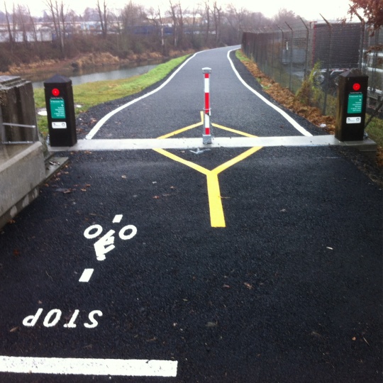
(View looking west from Vancouver Ave.)
(Photos: Portland Parks & Rec)
Portland’s newest section of paved off-street path is now officially open. Back in October we jumped the gun a bit with our story about a new, 1.2 mile section of path along the Columbia Slough. Today, Portland Parks & Recreation and the Oregon Department of Transportation announced the opening of the Columbia Slough Trail, a “major new biking and walking path”.
The new path winds above the Slough between N. Vancouver and Denver Avenues. According to Parks, it cost $610,000 with $460,000 of that coming from an ODOT Community Enhancement fund (leftover from their I-5/Delta Park highway widening project).
Parks says the path, “Offers bicyclists and pedestrians an off-street alternative while providing amazing views of surrounding scenery, birds and wildlife from the shore of the slough.”
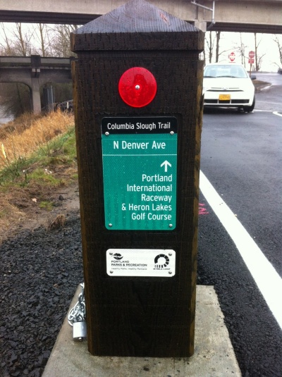
Also in today’s announcement, Parks Commissioner Amanda Fritz said, “I am glad to hear this valuable project is complete and can begin further enhancing Portlanders’ quality of life. I appreciate the extensive work of both our PP&R staff and ODOT to provide these improvements with enhanced bike and transportation options for everyone to enjoy.”
The path is a welcome addition to north Portland’s transportation network. It offers a much-needed and safer alternative to riding on Schmeer Road and provides a direct connection between many north Portland neighborhoods, Portland International Raceway, the Hayden Meadows Shopping Center (which includes a Lowe’s hardware store, among other things). You can enter the new path from Vancouver (map), Denver, or Whitaker Road.
While you’re out enjoying this new path, keep in mind that ODOT is cooking up big changes in the area. As we previously reported, this new path will soon make a direct connection across Denver to an existing piece of the Columbia Slough path, a new bikeway adjacent to Denver Ave., and more.



Thanks for reading.
BikePortland has served this community with independent community journalism since 2005. We rely on subscriptions from readers like you to survive. Your financial support is vital in keeping this valuable resource alive and well.
Please subscribe today to strengthen and expand our work.
Ha ha, the first picture made me think of a metered onramp.
Do you have a picture of what is looks like going under denver to continue west? Basically right where the post is in the second picture. I thought this project was supposed to address that section, which is super sketchy having to go against a one way street to continue on the path.
The Denver ave underpass/Schmeer Road is currently a one way street/exit for traffic coming from Denver Ave southbound.
See the previous post Jonathan linked in the last para; major changes coming to the Schmeer/Denver intersection.
Yes, that’s why I was curious if the changes had already happened. From that post: “That’s Schmeer Road in the foreground, which will eventually be closed to auto use by ODOT and connect this path with others.”
This is just a perfect example of a small gap completely screwing up a pretty long bike path.
I think I was pretty hard on Jonathan for jumping the gun, but the trail looked very open and usable a few weeks after that. Vancouver-Slough-Whitaker immediately became my new favorite route to points north of Kenton.
I’m not sure the Slough Trail will ever be “North Portland’s Springwater” but that’s not necessarily bad. It’s very direct, you don’t have to detour through Kenton, and it isn’t broken up every half mile by difficult intersections with 9000 lanes of traffic or blind, downhill corners. You’re also not likely to happen upon any sketchy customers at night.
Definitely. I was riding on it at the beginning of November.
Nice.
Yes…I have been enjoying this trail connection for many weeks now…though I wonder if there now will be the “missing” signage (advance warning of bicycle/ ped crossing) on the north to west bound movement from the Vancouver bridge path to the new path…plus any marking for this crossing? A marked refuge island here would be best too.
hope they plan on resurfacing the existing slough mup. It is really rough.
I relish the rough section south of PIR.
For the fresh section, you might wanna tuck your water bottles in your jersey or get some of those water bottle condoms.
Plenty of Canada goose poop on the path. 🙂
This has been a long time a coming. So glad its done. I believe the next planned segment of the Slough Trail going eastward toward 33rd and North to Marine Drive is in the works.