– More photos and video below –
(Photos © J. Maus/BikePortland)
As we shared last month, the Bureau of Transportation has been working on their NE Multnomah Street Pilot Project through the Lloyd District. They’ve made some exciting progress and I finally got out there to see it this morning. I shot video and photos and here are my impressions…
This is an unprecedented project for Portland. PBOT has taken an ugly, 1970s-style, wide and forgotten street and they’ve reduced the number of standard lanes and introduced a protected bike lane. This is a big deal folks. Not just for the street design itself; but because of how this project came about. Instead of a nasty fight with real estate developers and other interests, PBOT was able to actually work in partnership with Lloyd District power brokers to make this happen.
After these same business interests flexed their muscle and squashed the NE Holladay project, PBOT was able to pivot from that contentious atmosphere and come away with a transformative project on a main street that is poised for serious growth and development. On NE Multnomah, bike access has gone from a narrow and seldom used bike lane to a much more appealing protected bike lane. Now, as the street grows up and becomes more vibrant, it will have quality bike access from the start.
PBOT is still not finished; but there’s enough on the ground to get a good sense of things. Let’s take a quick tour…
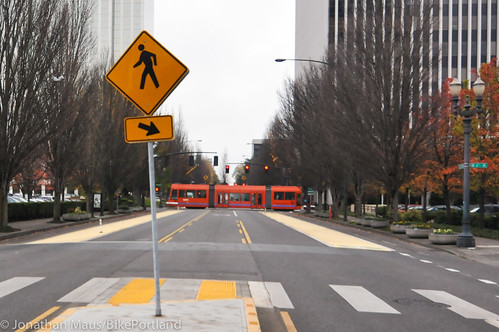
Here’s a (not so great) photo of the general cross-section (with a streetcar passing by on NE 7th)…
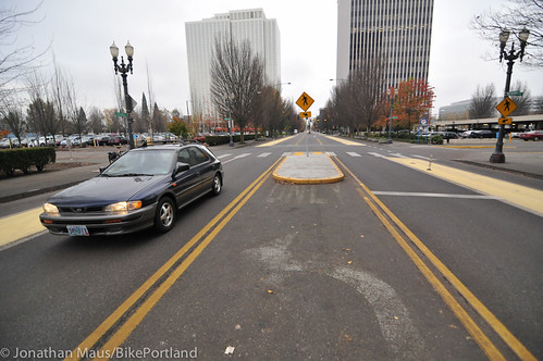
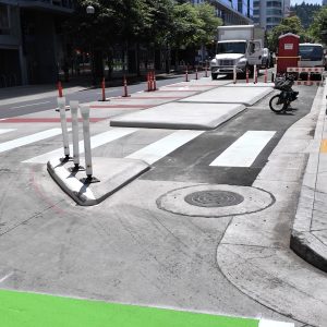
And another wide shot of the cross-section. Note the old, left-turn lane markings where a new median now stands…
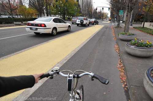
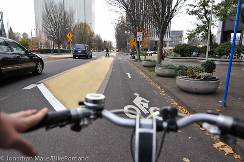
Heading east from Grand Ave, you can see where the old bike lane stripe used to be (just to the left of my stem)…
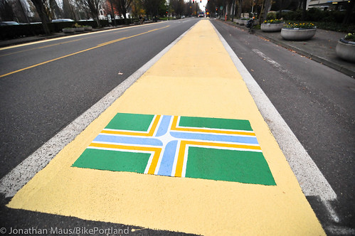
One very cool feature are the Portland flag symbols PBOT crews have placed at the start of several intersections. Remember the “bike lane characters” PBOT used to create from leftover thermoplastic? These flags are done in that same spirit (they also appear on speed bumps on the N. Michigan Ave neighborhood greenway)…
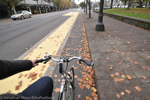
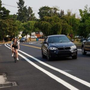
Continuing to head east (now at about 7th), you can see how much wider and more pleasant the bikeway is compared to its old self…
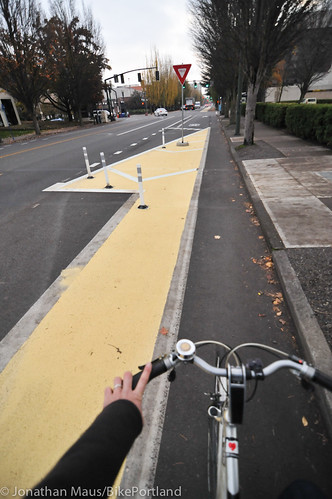
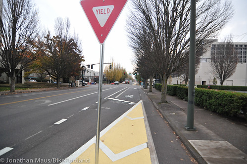
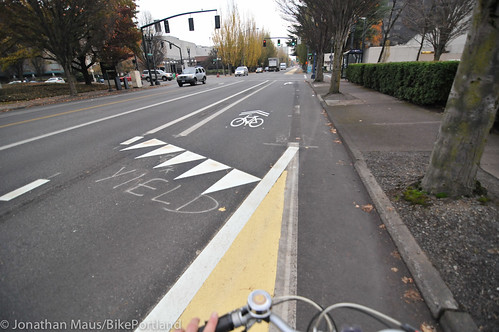
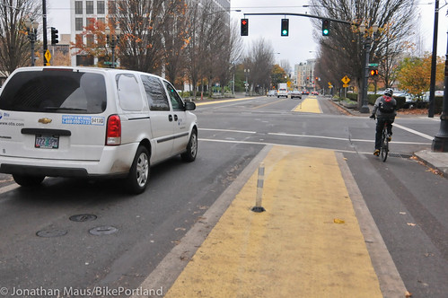
To deal with right-turning vehicles at intersections, PBOT has taken the “mixing zone” approach. After seeing much of this in New York City, I think it’s the right design. It’s not ideal; but given the much higher costs of other options (new transit stops on median islands, new bike-only signals, and so on), it’s not a bad way to go. Keep in mind that, because of all the features of this road diet (some yet to come), auto traffic should not be too high. The mixing zone will cause some stress for some; but I think it’s a good enough design to start with. Let’s see how it turns out…
Heading further east, here’s how the bikeway looks at Holladay Park…
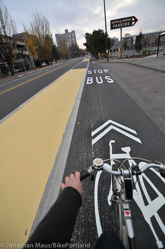
Coming up to Lloyd Cinemas, note how PBOT has handled the bus stop. A sharrow denotes that people must share the space…
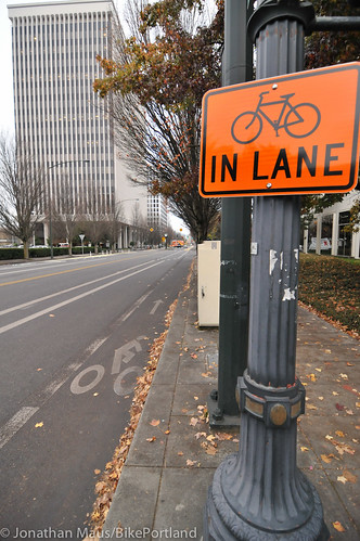
PBOT has also added “Bikes in Lane” signs along the route…
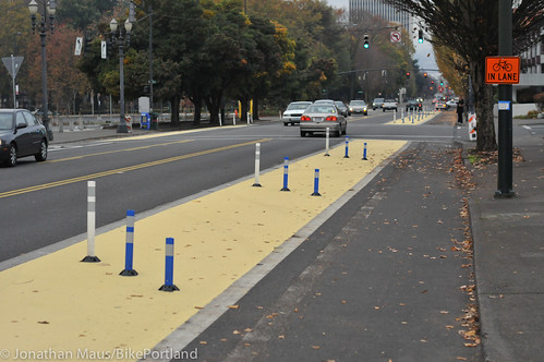
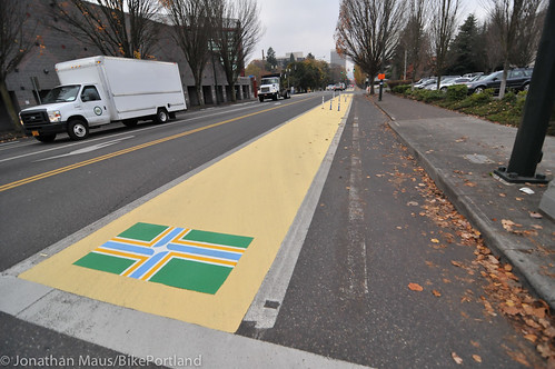
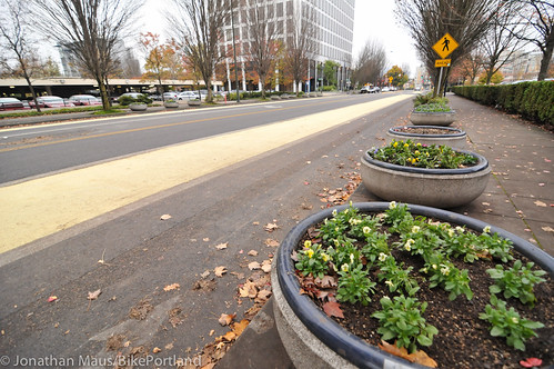
Here’s another perspective, looking west (toward downtown) at NE 7th Ave.
And it’s worth noting that PBOT intends to move these planters (re-used from the old transit mall downtown and currently on the sidewalk) over into the yellow-colored areas in order to create more physical separation and calm traffic…
To give you another look at what it’s like to ride, I shot the video below headed westbound from NE 15th all the way to Grand Ave…
PBOT is still working on this project. They are out there right now tweaking the signal timing to favor bikes. It also didn’t look like they’ve done much between MLK/Grand and the Rose Quarter Transit Center yet. I’ll get back out there when it’s done. But so far, I like what I see! And I especially appreciate how PBOT went back to the drawing board and improved the bike access after the initial designs were heavily criticized.
Now, we need to improve NE 7th (and make a bridge over I-84!) so we have an equally excellent north-south route. And of course, seeing this street evolve makes me wonder what other locations we can do similar things (Burnside Bridge comes to mind). Stay tuned.



Thanks for reading.
BikePortland has served this community with independent community journalism since 2005. We rely on subscriptions from readers like you to survive. Your financial support is vital in keeping this valuable resource alive and well.
Please subscribe today to strengthen and expand our work.
The planters will be a nice touch. Someday, I expect a permanent meridian thick with green plants will really add color to the neighborhood.
Very happy to hear they’re tweaking signal timing. My commute just got 1000x better. Thank you, PBOT.
A couple questions for those that have ridden here:
Can two people ride side-by-side?
Can faster riders pass slower riders, while still staying in the cycle track area?
In some spots, probably. In others, barely. That will be something I’ll be watching closely. Obviously, it will be relatively easy to enter the yellow-area and/or leave the protected area completely, but I don’t think that’s ideal.
Not being able to move into the buffer lane because transportation planners decided to plonk large circular planters and rows of bollards in the middle of perfectly usable passing space is extremely irritating. Move the bollards to the outer edge of the buffer zone and create a fast lane.
“create a fast lane” == awesome.
Right now, “buffer lane” is an oxymoron, as “buffer” != “lane”
I’d be surprised if the city’s intent is for allow for routine encroachment into the buffer, whether by people in cars or in bikes–it will happen, of course, but likely not by design.
I have never heard the term “encroachment” being used to describe a motorist passing slower moving traffic.
It’s not encroachment when you use an actual (unoccupied) traffic lane for that purpose.
The buffer does not equal “wider bike lane”. The buffer is not a traffic ane.
Perhaps you would if motorists routinely began using the left turn lane as a passing lane. A buffer is a shield intended to offer protection from some hazard. Ride in the buffer and you’ve removed the protection that it is intended to provide.
Can a street sweeper fit through the bike lane?
Nope. Saw them out there recently blowing all the leaves from the new bike lanes into the street where the street sweeper could get to them.
Absolutely love the Portland flags in the buffer area. Awesome idea.
This looks like a huge improvement! I do have two questions though.
1. Why are there bollards in the middle of the bike lane? http://www.flickr.com/photos/bikeportland/8169975817/
2. Why’d they go with yellow instead of green? This seems like it’s another change that’s unnecessarily confusing for drivers. Eg. “Can I drive in the yellow lanes but not the green lanes?”
David, the yellow part is the buffer zone. The bike lane is curbside and it’s unpainted.
Wow. Looks a lot better than before, at the very least. Let’s keep projects like this rolling, and make unprecedented projects the norm.
Impressive.
Oops. I get it now–I had to actually watch the video. So NOBODY should be in the yellow part, the bike lane is to the right of that, right?
it will be easier to know to stay out of the yellow lane when it is filled with planters
Looks good! It does look a little confusing. Downtown the green area of the street is the bike lane but here it looks like the bike lane is to the rignt of the green paint. I would think the city would try for a little more uniformity.
the bike lane is to the right of the YELLOW paint…
LOVE IT!!
Will there be bicycle stencil markings added in the lanes, I wonder? It does not look like a bikelane to me at the moment, and I am a daily cyclist.
ooohhh… Is that what they have planned for Barbur Blvd?
http://www.flickr.com/photos/ufobike/sets/72157631803220884/
Yield as you enter the bike lane? Bikes and cars suddenly sharing the road? I understand this is a shared zone? Just seems a little disconcerting to more timid cyclists. Otherwise, love what I am seeing.
When a repaving occurred on SE Woodstock I noticed a drop in the right and left shoulders. About 4 feet. It looked like a small cycle track was being implemented to me. I already thought it odd the st was being replaced as it seemed perfectly fine, there must be other access improvements for cycling being added. Nope.
But if you take a look it appears as if some space is being considered (and it would be a great addition!)
I think the confusion of the paint will go away when the planter boxes get moved. Then it will be obvious. We have to keep in mind that this is still unfinished.
Overall through I would say this is a 100% improvement and really goes to show how far a little bit of compromise can make things better for everyone. I’ve come to appreciate in the past year how much better riding a bike is when there is a physical seperation between myself and car traffic. This goes to show there are many opportunities to do this with relatively minimal cost so long as we are willing to think outside the box a bit.
I agree that the “mixing zone” is not the best but given the cost it is far easier to ride with and safer than what we had before.
That looks great!! That Lloyd Center area needed this SO badly!
FTFY
Looks to me as though those right-only lane merge points are the worst of both worlds. The big advantage of having dedicated right-only lanes is so that there can be a crossover/merge zone that extends for 50-100 feet, allowing right-turning drivers and through cyclists some negotiating space where nobody has to stop. With this arrangement, safety-minded cyclists will often end up stopping at these points, not trusting that drivers will actually yield, and yielding drivers will end up stopping (and backing up auto traffic) to let bikes proceed. Those are just the scenarios where nobody gets hit.
What is the section (ending at about 2:00 in the video, I think) that looks like a double-dashed bike lane that ends in a wall of yellow paint and bollards? Is that a parking lane? Doesn’t appear to be as it starts in a bus crossover zone…?
Keep in mind that the design isn’t 100% complete… But that being said, that section shows a truck/service/pick-up-drop-off zone in front of a building, so I assume that’s why PBOT has not put any paint/bollards in that section. Teh “wall of yellow paint” you see is simply the design picking up again after that loading zone/pull-out.
That is a metered 15 minute parking pull-out, and it’s been there from before. The double dashes represent the continuation of the buffer through the pull-out zone–it’s expected that people will maneuver their cars in and out of that zone all day, so dropping the paint there should be an indication to bikes that the buffer lapses there and that cars will be crossing over to/from the parking area.
watching the video a few questions come to mind…
Is the paint non-slip? that guy flying around you at the start made me worry about sliding…
you rode into the buffer area to go around a car in the turn lane… will they be painting that thin strip next to the turn lanes?
why do they have to grind the old bike lane line down leaving uneven pavement? can’t they blast the paint off without damaging the road surface? it’s nice that it’s wider, but now there’s grooves in the middle causing issues for skinny tires…
It should be fairly unslippery, if the city’s using the new paint (different colr) that they also used down on Oak & Stark, reference Jonathan’s earlier story.
That’s my route to the Blazer games, I rode it last night, I felt very safe. I hope it encourages people to ride to events at the Rose Garden & Memorial Coliseum.
The city’s plans are at their website:
http://www.portlandoregon.gov/transportation/article/417214
Everybody–this is a low-cost two-year pilot, meant as an experiment to inform the district and the city how different measure work/fail in the implementation of the road diet. After the pilot, the city intends to implement more permanent and construction-heavy feature changes for a more permanently defined “main street” streetscape.
There’s nothing to stop the city & property owners converting it back to a five lane auto arterial once the pilot is done…
…nothing, except probably demand from the community in the form of (1) increased use by people on bikes and on foot, and (2) citizen input. Tell the city what you think of the changes and how they work for you, once all the pilot changes are done (before Christmas). Let them know again in six/twelve/eighteen months.
Also, for the “main street” vision to be realized, there need to be more reasons for people to want to visit and use that street on bike or on foot. Right now the Lloyd TMA’s pedestrian committee is pushing an initiative to bring more food carts into the district (right now there are just 3 or 4), and possibly a real food cart pod. If you want to support this, contact the TMA, contact the city, contact your favorite food cart owner, and help push this vision closer to reality.
So if it’s a pilot … get out there and use it! We want more. 🙂
Are those Portland flags MUTCD compliant? Nah, seriously — this is a great achievement for Portland. This is the kind of thinking-out-of-the-box style we need to apply to our city’s odd collection of variously sized right of way. Thanks to everyone who stepped up and asked PBOT for improvement on their initial design.
Please take 2 minutes and send a short note of thanks to Mayor Adams and PBOT Director Tom Miller. Heck, consider CC’ing Charlie Hales & Steve Novick while you’re at it. Let’s make sure this momentum for physically separated bikeways continues over the next 4 years.
Those emails:
sam@portlandoregon.gov,
tom.miller@portlandoregon.gov,
charlie@charliehales.com,
novickforportland@gmail.com
Agreed! I would like to think that one very worthy interpretation of the mayor-elect’s platform slogan “basic service” is a return to the pre-auto-boom error — oops, I mean “era” 🙂 — in which city planners focused on accommodating people> on the city streets, rather than machines. Thanks Jonathan for that terrific piece this week on Mark Gorton.
Great idea.
How does the mixing zone work if right turn on red (RTOR) is allowed? I imagine drivers will be annoyed if they want to turn right on red and a cyclist is stopped in front of them because they are continuing straight. In NYC and in most places in Europe this isn’t a problem because RTOR is banned, but that’s not the case in Portland and most US cities.
No different than when a bike box is at a light or a bike lane is to the right of a vehicle lane at the intersection. Right turning drivers in vehicles routinely wait for me at red lights along NW Broadway on my way toward and beyond Burnside.
Thanks for the info. I’m not from Portland, but when I biked there, I felt that people were a LOT more patient and careful around cyclists than they are here in NYC.
I should also add that this is a huge step for Portland.
When protected lanes like this were implemented in NYC, there was an adjustment period as people got used to the design. There will likely be a similar period in Portland, so give it some time before judging it. Good luck!
Now if something gets built on all those Lloyd District parking lots! I hear some things are in the works. And of course, it time to really push for the 7th Avenue Bridge!
Its a big improvement, and it helps that TriMet redid the 70 & 73 and reduced the number of bus lines along most of the way. “Playing tag” with four different bus lines used to get old pretty fast.
I can see this from my window. I ride to work nearly every day, but I actually don’t ride this road. I ride one block over where the original location was going to be. I am extremely excited about this even if I won’t be riding on it much. I do walk on the street often. I think this street has a chance to become something very special when you take into account the new bike lane, the road diet and the new street car.
My criticisms
1a) While bike lane width is mostly satisfactory, at 1:14 bike lane and buffer seem to get unpleasantly narrow. If the bike lane anticipates high volumes of bicycle traffic, it seems perhaps just a wider, colored bike lane may be more appropriate.
1b) Wide buffers are absolutely necessary for subjective safety, but wide bike lanes are also pleasant. I do not know the exact measurements here but perhaps a foot could be taken off the buffer to make a wider bike lane without sacrificing the comfort provided by the buffer?
2) Seemingly zero accommodation for 2-stage lefts, which is crucial if this is to attract and accommodate the 8-80 demographic.
3) Bike lane maintenance could become an issue if the city neglects the need to keep the bike lane clear
4) Bus stop design isn’t optimal
All in all, it’s a good draft but could be improved before the final design is implemented.
I think it is worth noting how quickly this seems to have come to fruition after Ashford Pacific jerked PBOT’s leash on Holladay. It would be nice if the public were able to get PBOT to work this fast on other projects. I guess you need to have a huge amount of property waiting to be developed to get a City agency to fire up the construction trucks. Maybe if we get Ashford Pacific on-board and convince them that removing I-5 from the eastside will make their proposed super-block development sell better, we can actually get it done.
Sorry, maybe I need to drink more coffee before I can lose my cynacism; Great work covering this story Jonathan! I’m actually excited to ride to work tomorrow so I can see it for myself.
Okay, more coffee comsumed; Thanks for shooting the video Jonathan, it makes it all come alive. Have to admit it looks a little confusing at first, I’m so used to the paint being where I need to ride. Two things I noticed: 1) At the mixing zone, bikes need to go left into the (traditional-looking bike lane to clear the way for right-turning vehicles.
2) I’m thinking PBOT needs to get those leaves blanketing the right half of the bike lane or it’s going to get slippery when wet. This would be a great opportunity for PBOT to show that they are serious about being able to keep the lane clear.
in holland average cycling speeds in urban areas are 9 mph (really). at this speed wet leaves are not a problem.
at 1:58 was an okay opportunity to yield to a pedestrian
i noticed this too.
I disagree. The guy wasn’t at the curb yet and he was distracted by his phone. The law clearly states the person operating the vehicle must have time to react and stop and notice the person waiting. I was there. I didn’t feel like that guy needed to be stopped for and I stand by my decision.
i said it was an okay opportunity. people talking all the time about how each of us is an ambassador to whomever. stopping for an oregon walker even when it is not strictly necessary can earn a point or two.
the guy may have been “distracted by his phone,” but he did not break stride until you rang your bell. you can stand by your decision, and no harm no foul as they say, but i would have made a different decision in the same circumstance.
in fact, i would either not have blown by the aramark truck at full speed or i would have given it a wider berth, which would have set up a different scenario anyway.
but these are perhaps questions of style.
russ,
I hear what you are saying. You were not there. Let’s not make this out to be more than what it was. I am extremely courteous to people on foot… almost to a fault of getting rear-ended by other people on bikes when I stop for them. I feel like I made the right decision in this situation. Thanks for the feedback.
through the magic of youtube i almost felt like i was there. i almost felt like it was one of those times when i blew past a pedestrian who had in fact stepped off the curb and then immediately thought, damn, i should have stopped. or at least mumbled “sorry” instead of ringing my bell. but then i didn’t have to deal later with anyone second guessing me on a blog.
I walked down this street today, and having seen the new changes in place, am NOT impressed.
1) There is nothing to let drivers know it is a bikelane. Up close and in person, it looks like a row of parking bays.
2) Drivers were driving in the bikelane for entire block lengths, especially when they wanted to make a right. Especially taxi drivers. Car drivers were illegally driving in the bikelane and squeezing between the bollards and the curb to turn right.
I am not happy with the outcome of this project at all. It needs –
1) Solid concrete barriers or planters of some kind in the yellow painted section to PHYSICALLY prevent motorists from driving in the bikelane, like those for the cycletracks in Vancouver BC – http://www.flickr.com/photos/sfmtabike/7726598014/
2) Bicycle stencils added to the bikelane. FOR THE LOVE OF GOD.
The planters are allegedly coming. I would assume the stencils are too since this project is “not yet finished.” I agree that it’s not entirely clear from the cockpit of a car along the length from Holliday park to NE 16th (this is the only section I routinely drive). But I expect it to improve.
Yep. Planters are staged in the “furnishing zone” (sidewalk) for some segments and will be moved to the buffer when other treatments are done. There’s lots of other work remaining too.
Looks fantastic.
Only problem I see is the 3rd merge area (in the video) which is the merge area in the pictures. Looks like the bike lane is very narrow here, so bikes enter the merge area very far to the right, instead of directly in the middle. Many cyclist will then place themselves to the right of right turning cars, a bad idea.
I would use some of the space before the merge to center the bike lane.
One other issue is the “stop here for pedestrians” signs, located on the sidewalk. Would be best if those, an all auto signs were moved to the new yellow median, as the yield signs are.
Looks like a great start! I may try riding this as my commute instead of Broadway or Tillamook (Tillamook is relaxing, but a longer route).
I love it! As for improving NE 7th….I have lived on NE 7th for the past 16 years, and used to use it every day. That is until the streetcar tracks went in. Now I use NE 9th, which is a lightly traveled 4 car lane road. NE 9th is absolutely the best N/S option available. There is no reason to keep 4 car lanes. There should be 2 car lanes and 2 protected bike lanes until Broadway and then it should become a bike boulevard all the way to NE Ainsworth, with an optional jog around Irving Park. N/S routes are sorely lacking on the Eastside, and this would be cheap and easy.
paving on 9th north of broadway is horrible. and you would have to divert around irving park.
Thanks for the photos and video, Jonathan.
Since I now commute to my job in the Lloyd District on foot more often than by bicycle or bus, I’ve been eager to see how the pedestrian improvements associated with the pilot project will eventually play out. I know going from paper to pavement with projects like this can sometimes lead to mixed results; e.g., think Eugene’s downtown pedestrian mall.
Based on my experience commuting on foot on NE Multnomah over the last two weeks, I’m encouraged. Motorized traffic seemed to be traveling slower and motorists seemed to be more observant of pedestrians and bicyclists. Undoubtedly, some of this could’ve been attributed to the construction underway and/or confusion because of the changes. Hopefully PBOT’s pre- and post-project traffic studies will confirm these as new behaviors though.
On a separate Lloyd District project note, I want to thank the Lloyd Center Mall owners for building the new pedestrian connection (sidewalk) and adding new lighting, landscaping and rain gardens in the Regal Cinema lot. These are welcome changes for those of us that cross the lot every day on our way to/from work.
Nice job on this, though I wish the took the approach I saw in Copenhagen with the bus stop. Buses there do not get off the main traffic lane. They just stop in it and there’s a crosswalk that goes across the bike lane for folks getting on/off.
I don’t know if anyone is still reading these comments – if so, I have a question about the new bike lanes. I’ve been taking this way to communte this week – when I get to the Rose Quarter and want to turn left to get on the esplanade, it seems that I need to turn left where it says No Turns. Can bikes and buses turn here? Or only buses? If only buses, is there another way to go?
Thanks for the feedback – hopefully I’m not being dense and missing something obvious…
greatdane,
You can definitely turn left there. Bikes and buses are the only vehicles allowed to go south through that intersection.
Good to know, thanks.
OT: While surfing Streetviews of that intersection I found found a contemporary picture of Citizen Kane & Rosebud: http://goo.gl/maps/YsY1E
🙂
I use this street to ride home from work almost every day. I mostly consider this to be a confusing mess for all users. I’m not impressed.
o.k. I turned the corner to the right from ne 15th to multnomah st and seen all this crazy stuff….are these going to be parking stalls? whats up with the port of portland flags thats kinda cool wow!!! are we going international or what? then I realized that whoa! they cut a lane out!! Whats really going on. It really does not look like any kinda bike lane and really now that I think about it… I did’nt even see a cyclist! Holy Crap!!! then tonight i drove back through in the pouring rain in the dark and was turning from ne 7th to the left and was more worried about the center median of concrete realizing I swinging way wide headed toward one of those wonderful planters!!! AWSOME!!! I understand the green boxes at stop lights and perhaps we need some at stop signs as well. Maybe we need to have a Cyclist instruction class in public schools these days. And require a License to ride and number plate. I think other counties have that don’t they? I know I did was proud to ride my Huffy with my Toucan Sam!!!
And I see ONE major problem …..
1. If the bike lane is too far off to the right even a driving instructor could run over a cyclist if they were to be turning right because they won’t be in the side view mirror to be seen.
I suggest instead of going through all the wrangling about this that and the other and lets be honest here….we don’t see any other way around this but to build a lighted tunnel that is powered by solar panels and charge a toll booth…. OR!!!! make a pedestrian/cyclist stop light put the road back to the way it was. Otherwise I’ll just cruze around town following cyclist that run stop signs and using the automobile left turns on red and let them know that bad things happen when you do that on my PA.
great story bro