this into a larger road to handle 200
extra cars daily.
(Photo: Multnomah County)
The construction of the new Sellwood Bridge is already having some impacts on the nearby transportation network. As The Oregonian reported last month, a decision to relocate an access road to Highway 43 for the Macadam Bay houseboat community just north of the bridge “ignited a fierce debate”.
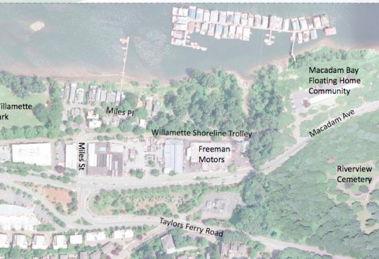
At issue was where to put the estimated 200 cars that go between the houseboats and the highway every day. The county considered a myriad of options, but there was opposition to each of them. Of particular interest to readers of this blog is that the Willamette Greenway trail begins on SW Miles Place and runs parallel to Highway 43 in this same area. Also, as part of the Sellwood Bridge project, the trail will be improved and connected to the bridge.
Here’s an aerial view of the area in question (supplied by Multnomah County):
If the houseboat traffic was put onto Miles, it would have meant that a portion of the future trail would be a shared auto/bike environment. With an additional 200 cars, Miles would be more congested and, due it being rebuilt with full curbs and sidewalk, the traffic would likely have been higher speed as well.
Roger Robinson, who lives in the area and has been attending the Community Advisory Committee (CAC) meetings for several months, began alerting me to this situation back in April. At that time he was very concerned that SW Miles Place would be rebuilt to accomodate the additional auto traffic and that the quality of the future trail could be in jeopardy. Another red flag was raised in The Oregonian article after a CAC meeting last month:
“One group not heard from at the meeting? Trail users. Hundreds of people walk, jog and cycle down the middle of Miles Place on weekends. After the new bridge goes in, that is expected to rise into the thousands.”
Fortunately, despite trail users not speaking up and Robinson’s fears, it looks like a good solution has been found (thanks in large part to the work on the CAC by BTA citizen rep Richard Marantz and PBOT’s bike planner Roger Geller and citizen activist Roger Averbeck — both of whom were involved in the planning.)
The CAC has opted to create a new driveway and access road just south of the Freeman Motors parking lot. Robinson said this is “great news” because it’s the only option that keeps traffic separated from the trail. (Houseboat owners aren’t nearly as thrilled, because they were hoping for a more private, exclusive driveway.)
Multnomah County spokesman Mike Pullen shared a plan drawing of the CAC’s preferred alternative (note the 16-foot “regional trail” and SW Miles Place in the upper left):
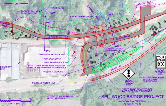
The cost of this recommended option is estimated at around $4 million. From here, there’s another meeting on June 18th and then this will be folded into the final design package that will be voted on by the Multnomah County Board of Commissioners on June 21st.
Now the fun work begins of designing the new segment trail that will connect from the Sellwood Bridge to Willamette Park via Miles Place. Stay tuned and check out SellwoodBridge.org to learn more.


")

Thanks for reading.
BikePortland has served this community with independent community journalism since 2005. We rely on subscriptions from readers like you to survive. Your financial support is vital in keeping this valuable resource alive and well.
Please subscribe today to strengthen and expand our work.
I live in the Miles neighborhood. The article summarizes everything well. The residents here are very supportive of the trail on Miles Place. Some people who live here (me included) first found the neighborhood while biking.
The first priority was to keep the additional houseboat traffic of 200+ cars/day off Miles Place, Miles Street and the trail. 200 may not sound like much, but it triples the existing traffic that comes into the neighborhood. And considering Miles Place is a dead end, the auto count drops down to nothing at each end, so going from nothing to 200+ is a big deal. The other options the project considered actually could have forced yet hundreds more vehicles from the commercial end of Miles Street onto the trail as well. The option “1c” that the staff and advisory committee supports is by far the best one for the trail and neighborhood.
So, assuming the project sticks with that option (running the houseboat driveway out near Freeman Motors) the next step will be to make sure that changes to Miles Place that will be done to accommodate increased bike and pedestrian traffic after the bridge is built are done well. We could get anything from a 1960s design that separates everyone into restrictive, narrow lanes, or we could get a more forward-looking design that mixes modes, but gives bikes and pedestrians priority over cars. With the very low vehicle counts, and residents actually hoping for a solution like this, there’s great potential for a great solution.
Of course, this all hinges on the houseboat traffic being kept off Miles Place. If that gets reversed, all bets are off.
The desire for a more “private and exclusive” public road smacks of over-privileged delusions of superiority.
Of course if they want to pay for it entirely themselves while still not impacting non-automotive use I’m game.
How much room does this leave between the regional trail and the new floating house driveway?