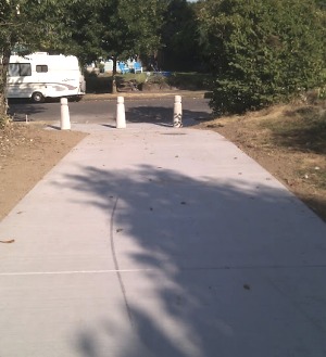
shared-use path PBOT has built between Westanna and Newell
streets in north Portland.
The Portland Bureau of Transportation has just completed a new shared-use path as part of their North Portland Connector neighborhood greenway project. The new pathway connects N Westanna Ave to Newell Ave and to the Peninsula Crossing Trail just north of Lombard.
The pathway is a crucial section of PBOT’s east-west bike boulevard that allows people to ride safely across the north Portland peninsula west of Interstate Avenue via a combination of streets including N. Houghton, Dana, and Terry.
Kenton resident Nick Welch works in St. Johns and says this greenway is exactly what he needed. “Now you can finally get across the North Portland peninsula without touching the abomination that is Lombard Street.”
Welch said he’s already been using the Houghton/Dana/Terry greenway, but before this new path was built, he was forced to take the bridge on Lombard over the railroad tracks. Lombard (as all locals know) is an ODOT-owned freight route and high-speed arterial that doubles as the Highway 30 bypass. It’s a street you rarely see people biking on.
Here’s more local knowledge from Nick about how this new path improves his commute:
“The real problem is getting to/from the Lombard bridge on the east side. Previously it required riding along Lombard for a few blocks between the bridge and Westanna. Riding in the street is miserable, and riding on the sidewalk is probably dangerous (with all the driveways, intersections, etc.) and definitely tense. There was part of a path that took you from the Peninsula trail to Newell, but it was a dead end, and you still had to head out to Lombard to get to Westanna. It was basically a dead end loop that was only useful for the apartment complex on that dead end. Now you can ride from Westanna directly to/from the Peninsula trail and the only contact you have with Lombard is over the bridge itself.
It’s a very nice upgrade to the experience.”
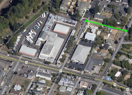
Here’s a map view of the new path:
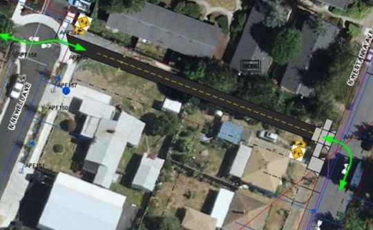
And PBOT’s design drawing:
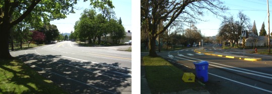
In addition to this new shared-use path, PBOT has also added several crossing improvements, including new crosswalk striping and median islands where Houghton crosses Portsmouth. See the before/after photos from PBOT below.
Learn more about the North Portland Connector project on PBOT’s website and follow all of their exciting work on bike boulevards via the main Neighborhood Greenways site.


Thanks for reading.
BikePortland has served this community with independent community journalism since 2005. We rely on subscriptions from readers like you to survive. Your financial support is vital in keeping this valuable resource alive and well.
Please subscribe today to strengthen and expand our work.
Why does the “after” photo look like a winter scene?
Morning shot.
Google maps show this in green as a bike route, although their bike directions will need updating. I’ve submitted a problem report via their map reporting utility.
I submitted the same report! Strangely, even the pre-existing section of trail between Newell and Peninsula Crossing Trail wasn’t considered navigable by Google Maps.
We need more of these types of connections along our neighborhood greenways, particularly in poor connectivity areas such as outer east Portland. Unfortunately, they are difficult to implement and often face opposition from neighboring homeowners. I wonder what it took to make that connection happen.
– Discussions with 4 adjacent property owners who were using the space for various storage (Kyle Chisek)
– A gap in work at the Bureau of Maintenance (Lee Munson)
– Parks cleared the overgrown space with only a week’s notice.
Nice MUP addition. We got lost riding here once and complained about the lack of greenway signage as to where to go….then I found out they were building this. Hopefully as more of these get built there will be less resistance from private landowners.
Folks can also find progress around Swan Island. Waud Bluff Trail bridge construction is underway at the north end. Speed bumps and sharrows are on N. Michigan and Blandena which will connect the Going Bikeway to the widened Going Street sidewalk down the hill. And work is underway on the Channel Avenue sidewalk to the shipyards and the Ballast St. segment of the Willamette Greenway Trail.
Cool! I’ve been using this way quite a bit recently, and not having to touch Lombard will definitely be an improvement. Cannot wait for all the other greenway stuff to be put in. This new segment sounds amazing! I’ll try it out tomorrow. Thanks PBOT.
Unfortunately, you still have to hit lombard or fessenden to get across the railroad tracks, which is a bit of a pain.
exactly! this path did nothing to help avoid the Lombard railroad tracks…
Ah, yes. I concur. I should have written, “not having to touch Lombard AS MUCH”. Still, a good improvement. Yeah, I’d love a ped/mup bridge over the rail tracks, but I just have no faith that something like that is ever possible.
Yeah,it’s not going to happen, mostly because there is no access on the other side. Houses on Gilbert are all right next to each other, no gaps wide enough for a path of any functional size. (I know, mine is one of them! I’d love better access across the cut! but this is still an improvement.)
I don’t see the Haughton/Dana/Terry greenway marked in Google maps. Those section of roadway should be marked as ‘Preferred’ for cycling in Google Map Maker: http://www.google.com/mapmaker. I’m familiar with the tool, but not that area. Anybody want to mark it up?
I am also curious if smoothing the roadways on these boulevards/greenways is part of the long term plan. I love being able to take a calmer route to some destinations, but a lot of these streets have some really bad surfaces.
I’d really like to use these facilities at night more often, but find that I am more comfortable on a better lit/ smoother and more trafficked route, for fear of not seeing a pothole, uneven pavement, etc etc that might catapult me off my seat or worsse, and will take the busier route instead.
Are roadway surface improvements a part of the plans?
Neighborhood greenways are included in PBOT’s ‘streets of significance’ category that will be prioritized for maintenance in the future.
I live very close to this, and wasn’t aware of it yet; it’s a nice option. Lombard wasn’t that bad for those 2.5 blocks; it’s fairly wide and few cars park there, but I can see how some folks would not be comfortable riding it. I don’t see how there’s a Houghton/Dana/Terry greenway; neither Dana nor Terry go through very far. I’d either take Houghton to Woolsey, or take the shorter route of Houghton/Berkely/Willis to Woolsey, which gives you a light to cross Lombard. Then I’d take Willamette, and if I wanted to continue east, I’d take Bryant, Rosa Parks, or Ainsworth.
You’re describing a different, more southern route, which will not take you to Kenton, as this greenway does. Terry will take you right into Kenton. See the PBOT webpage for North Portland Connector — the map is there in a PDF.
True, but Dana does not connect with Terry, and neither streets are indicated as being a greenway. I’d rather take Willis, and drop down on Delaware or Denver, but that’s just me.
Dana goes south from Houghton to Kilpatrick, which goes east connects to Halleck, then south on Emerald and then east on Terry. Or, just follow the sharrow markings.
I tried it yesterday, and it is well marked. A very odd route, but I guess if you’re looking for a quiet route it works.
I was out riding on Sunday and found the new pathway, and it was great. Keep it up PBOT.
I can’t agree w/ Nick Welches assessment that N Lombard is an abomination. Certainly not for the fearful, but between SJ and Columbia Park,its wide enough for comfortable riding, and not the 5 lane divider like SE 122nd or Sandy. In short, this new segment will be welcome to some, but Lombard ISN’T that tough of a stretch.
The larger goal is to encourage the ‘interested but concerned’ group to use cycling for local trips. I believe the new segment will be a nice piece, esp combined with the new ‘Neighborhood Greenways’ like Central and such. That is where its utility lies.
And hopefully, more use for the Penninsula Crossing Trail. More users make a better,safer trail.
Looking at the city’s Bike Map,
http://www.portlandoregon.gov/transportation/article/322407
it looks like this link connects the “Central” bike blvd and the “Willis” bike blvd. And it crosses the railroad trench on the sidewalk of the Lombard St. bridge?
Looks like a great addition. A continuous bike blvd from downtown Kenton all the way to NW St. Johns.
Nice work PBOT, I’m looking forward to taking this new route to go shopping at the Grocery Outlet.
Ted Buehler