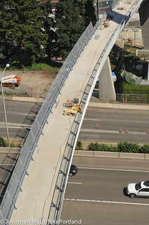
The Gibbs Street Pedestrian Bridge — a bridge built solely for people to be able to safely walk and bike across I-5 between the Lair Hill Neighborhood and the South Waterfront district — is now set to open on July 14th.
When I last reported on this project, the opening date was late May.
To celebrate the completion of the $12 million project (PBOT paid $2 million for it, the feds paid the rest), the City is hosting a ribbon-cutting party from 10:00 am to 2:00 pm.
While project consultants Alta Planning + Design say they expect traffic on the bridge to be evenly split between people on bikes and on foot, it remains to be seen what it will be like to ride on the new bridge. The steep stairwells leading from the eastern end of the bridge down to SW Moody Ave (connecting to the south end of the new cycle track) have wheel gutters off to one side. In addition, PBOT project manager Jean Senechal Biggs says bikes will be allowed in the elevators. In fact, she says, “The elevator was designed to fit a bike with a trailer attached,” (which means bakfiets and other cargo bikes should be fine too).
John Landolfe, who works with Oregon Health & Science University, commented in April that he’s looking forward to the project; but sees it as a byproduct of the vast barrier of I-5. “I’m pretty excited about it, but when you consider that it’s technically a highway mitigation project — and our urban core is only going to become more dense with walking humans — it’s also a great argument for why we really should bury I-5 on the east waterfront. Or else we’ll be building many more of these bridges in the coming years.”
Stay tuned for photos and thoughts after I get a chance to take a closer look. Learn more at GibbsBridge.org.


Thanks for reading.
BikePortland has served this community with independent community journalism since 2005. We rely on subscriptions from readers like you to survive. Your financial support is vital in keeping this valuable resource alive and well.
Please subscribe today to strengthen and expand our work.
I’ve long wondered why pedestrian and bicycle bridges over freeways like this aren’t made of large diameter clear plastic tubes. Much lighter, and thus surely much cheaper, no?
In any case it’ll be fun to see how well this fits with the other bits of related infrastructure in the vicinity.
On a related note, one single clear plastic tube with a walkway inside it, might have a Jetsons-like appeal, and of course it would keep the rain off. Though making it would be quite a manufacturing feat.
If plastic hasn’t caught on as a building material, I suspect it’s because the more traditional materials are stronger and can accomplish the same thing with less material, which means a smaller cross-section, smaller members, and a less bulky appearance. Although who’s to say a “bulky appearance” couldn’t be used to artistic/architectural advantage?
With plastic you would also have to look at slow long-term deformation (creep), ultraviolet degradation, and for the more brittle grades of plastic, cyclical loading and fatigue might become an issue as well. STRUCTURAL ENGINEERING NERDFEST.
As for cost, I wouldn’t even know, but the costs of a plastic bridge would probably include a lot of high-value professional labor costs (engineers & lawyers) to solve the problems above, and to demonstrate to the satisfaction of permitting authorities that the new material (one not as readily accepted by building codes) can be used safely.
Affordable plastics are not strong enough in a tube/pipe configuation.
Current plasics are still prone to “creep” where by they fail to maintain a rigid shape in the face of gravity’s pull.
As well plastics, especially clear plastics, are prone to ultraviolet damage causing embrittling along its entire exposed structure as well as any parts of the structure that the clear plastic refracts caputured UV at shallow incident angles. This causes very unpredictable areas of hyper advanced fatigue.
What you are looking for is transparent aluminum.
Who can start the buzz? Stop the CRC so we can afford to bury the I5! I have not idea what that would cost but that might be something I could get behind.
I am very excited about this bridge. It gives me another cycling route to get to work and another running route from the house. Awesome!
This would pay for itself twofold:
(1) in the initial sale of acreage. I-5 is 150ft wide just north of the Rose Quarter interchange. This works out to just over 18 acres per mile covered, more where it is wider due to interchanges and ramps.
(2) property taxes on such prime real estate. It seems such a waste, from a greedy politician standpoint, to let all that potential income go to waste in the hands of a DOT.
“Stop the CRC so we can afford to bury the I5! I have not idea what that would cost….”
The tunnel to replace the Alaskan Way Viaduct in Seattle is costing about $3 billion for something less than 4 miles of road.
It looks like burying I-5 would cost about the same as the CRC and the Alaskan Way project, around $750 million/mile — or about $1 billion/mile if we’re rounding….
A cut and cover tunnel would be cheaper. If it were a bored tunnel, they could also go under the river, getting rid of that horribly ugly freeway bridge in the middle of our city.
“While project consultants Alta Planning + Design say they expect traffic on the bridge to be evenly split between people on bikes and on foot,”
I would be surprised if even 10% of the traffic is by bike. There is an alternate route just a few blocks away (Sheridan) that does not require carrying your bike up/down 50 steps.
Where?
https://maps.google.com/maps?hl=en&q=Portland&ie=UTF-8&hq=&hnear=0x54950b0b7da97427:0x1c36b9e6f6d18591,Portland,+OR&gl=us&ei=1UL7T7K2J8LMqgHxlKGLCQ&ved=0CKQBELYD&safe=on
Sheridan St: http://goo.gl/maps/EMEJ
An alternate bike/ped bridge across I-5? Just a few blocks away? Really?
“alternate route”, not alternate bridge. It’s an under-crossing on terra firma with graded access. No steps or elevators. Sheridan street, by the old bus terminal. An area that could use renewal, and ties into the new Moody Street project.
how are we supposed to safely bike up and down all those stairs when the elevator isn’t working?
I wish they had taken a more simplistic approach and created ramps with all the room they had…
even a zig-zag set like the Hollywood transit center is better than carrying your bike up stairs or waiting for and tolerating the urinator (urine-soaked elevator)…
Hah, urinator!! Perfect…
I agree completely that the elevator was a stupid idea, just like the stairs on the Waud Bluff trail seems to be a waste of money. If you can not afford to build a real ramp, than why do it. Elevators go bad, are expensive, create bottlenecks and yes have urination problems. Stairs are just impracticable with all the new forms of bike transport/ trailers on the market now.
Example of a waste of an elevator….has anyone EVER seen anyone use the electric wheelchair elevator/lift to the Burnside bridge from the Eastside Esplanade? I have never seen anyone use it, but I remember that it was expensive……they should have used the money to create a better ramp than the stairwell/ keyed electric lift option.
And I am assuming that it is a 24 hour operation elevator? That just lends itself to all sorts of secluded late night debauchery….but it needs to be open 24 hours for transport……
They had plenty of room to build a ramp there. For 12 million we should have gotten a much better bike friendly product. What would have been wrong with an architecturally interesting spiral like on the Morrison bridge access from the eastside esplanade?
I have no problem with an elevator for ADA purposes, but I would have liked a ramped treatment much better than the stairs.
From what I’ve seen of it from the aerial tram, that elevator looks too small for a cargo bike.
Hey ramp people: do the math! ADA requires no greater than 1:12 grade so if the east side of the bridgehead is just 30′ above ground you would have a ramp over 360′ long not including landings every 30 linear feet! I don’t know how high it actually is, but it would quickly become exceedingly unwieldy to do ramps. I wish this law was more sensible.
This is a half ass (half completed) bridge. There is no crossing for the 99-E (Naito Parkway) though it was in the original plan. So You still have to go way out of your way or risk crossing the 99-E with no crosswalk if you’re on the West side of Lair Hill. This is just stupid and shows how much of this project was for show and how little care and thought went it to actual usability.
The Community Liason says as 99-E crossing is a “high priority.” So why was it dropped from the plan? Why, after YEARS of development, do they still not even have an agreement for a cross walk from ODOT? (let alone the under street tunnel in the original published plan).
People WILL cross Naito/99 near Gibbs St to get to the new bridge at rush hour. There WILL be close calls every day.
And someone is going to get hurt. But Sam Adams will have his flashy Grand Opening July 14 regardless.
You make a good point. For clarity, it’s 99W, not 99E.
99 is due for a major road diet. It is way over capacity for current and future traffic levels.
Adams gets to cut a ribbon and his Alta cronies got paid! Isn’t that the story on nearly every bike project in this town?
I know that ODOT, PBOT and TriMet all have additional improvements planned in that area. I’d recommend dropping your feedback into the Gibbs Street comment form and PBOT can forward it from there. http://www.gibbsbridge.org/Comment.aspx
July 14th: Woody Guthrie’s 100th birthday, …if he were still alive.
“This bridge is your bridge, this bridge is my bridge, from the Lair Hill bungalows, to the waterfront condos…”
that was sizzling satire.
ADA rules are clear for a good reason. There has to be an elevator.
But there is going to be a huge bottleneck… and if a group has two or bike+trailers or cargobikes in it, it gets even worse…. who made the decision to have it be seamless with ramps on both ends? Did Alta Planning tell them it was a bad idea to only have one side with ramps?
A ramp was originally planned but was cut for budget reasons. Guess they figured it was redundant.
On a loaded tour I easily climb those stairs in the Gorge with panniers, tent, sleeping bag etc in one trip every year. It would be harder going down.
If there were an elevator I wouldn’t wait for it anyway.
Doug, Google “8-80 cities”. Thanks.
“Reconnecting Neighborhoods – A Gibbs St. Bridge Celebration Bike Ride”
Saturday, July 14th, 2012: 12:15 pm – 2:00 pm (Low to medium difficulty)
Hosted by PBOT Transportation Options and SW Neighborhoods, Inc.
Come along on this easy-paced ride showing off transportation improvments for people on bikes and on foot in South Waterfront and historic Lair Hill / South Portland neighborhoods. We’ll tour improvements already made, like the Moody cycletrack and the Gibbs Street Bridge, look at areas where improvements are being considered: New crosswalks on Naito at Whitaker; New bike lanes and crossings on SW Kelly Ave; and discuss the issues and opportunities of the Barbur Concept Plan.
Meet at base of Tram at 12:15 pm, near “Go by Bike” valet & shop, roll by 12:30 pm. Loop Ride ends at 2 pm.
Free Tram Rides from 9 am – 12 Noon!
https://www.facebook.com/photo.php?fbid=3522564786704&l=31d53e431e
“It’s technically a highway mitigation project ”
I like this definition. It seems like all biking and walking infrastructure are essentially mitigation. It would be nice to work that into the debate. Bicycle projects are not roadway “extras” they are required because of the destructive nature of highways on mobility by any source other than private automobile. This is why they should be paid for with highway funds.
Thanks. Glad that made sense. I think it’s a beautiful project but bike/ped projects often come under fire for their price tag. I meant only to point out that its cost is not because it’s generally expensive to move bikes and people a few city blocks; it’s expensive to move motor vehicles underneath.
I’m glad this will be opening soon. My afternoon commute takes me within 12 feet of the west end of this bridge, and from that end it’s appeared complete and ready for about 3 months.
Now that this is almost done, can we go directly across the river and finally start working on Brooklyn’s connection to the Willamette? We’ve been promised a similar route across 99E for at least 20 years, with no apparent progress of late.
Forget burying I-5 on the eastside. Rip it out, and tear down the Marquam! With better lane configuration, the freeway currently known as I-405 could be rechristened as I-5, and could handle the volumes without ridiculously expensive changes.
Ramps are nice, but because (as pointed out above) they are so long they need to be built in addition to stairs, not instead of them. To get across Powell from my neighborhood, I have to take the 9th ave pedestrian bridge, which has corkscrew ramps on both ends. Recently I paced the length of the ramps, and discovered that they add nearly 500 feet to the distance I’d take I were allowed to cross the road directly. No big deal on a bike, but when I’m on foot I absolutely despise that thing.
Here is the link to the study by Alta, mentioned by Jonathan above: http://www.gibbsbridge.org/ProjectLibrary/BikePed_ProjectionsReport_8.26.08.pdf
Needs outdoor escalators ala Barcelona. 5 stories of stairs is a lot to ask, and with only one elevator, you’ll be waiting 5 minutes or so for each trip.
It’s official! The Hooley Bridge (aka Gibbs Street Bridge) is bakfeits compatible. Fits in the elevator with six inches to spare either end (and I own one of the really long ones). Way to go PBOT!