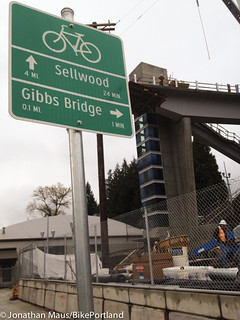
done, and the bridge itself is
coming along nicely.
-More photos below-
(Photos © J. Maus)
It’s been just about 16 months since the Gibbs Street Pedestrian Bridge broke ground. And lo and behold, it’s set to open late next month.
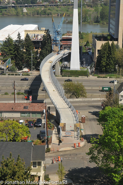
I took a ride in the Aerial Tram yesterday and snapped a few photos of the new bridge (scroll down). I didn’t realize this project was so close to completion.
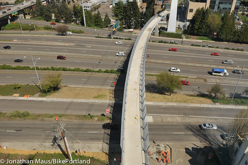
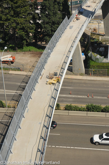
Once open, the bridge will connect the Lair Hill neighborhood to the South Waterfront District. The west end of the bridge is at the intersection of SW Gibbs St. and Kelly Ave. From there, the bridge winds over I-5 to an elevator and staircase that stand at the southern end of the new cycle track on SW Moody. The stairs are expected to be bicycle-friendly but I have seen them up close yet. I imagine most folks would just take their bikes on the elevator.
Here are a few more shots from above…
According to an analysis by Alta Planning + Design, usage of the bridge is expected to be evenly split between people on bikes and on foot. The cost was about $12 million, with $2 million of that coming from PBOT (their share of a 10% federal match). PBOT says we can expect a big public grand opening in late May or early June.



Thanks for reading.
BikePortland has served this community with independent community journalism since 2005. We rely on subscriptions from readers like you to survive. Your financial support is vital in keeping this valuable resource alive and well.
Please subscribe today to strengthen and expand our work.
It’s an interesting design for sure – too bad the end near OHSU couldn’t have had a ramp system to allow people to get up to the bridge without stairs or an elevator, but the amount of space needed to make the grade reasonable would have probably been prohibitive.
It’s really a shame that such a neat little neighborhood has been so chopped up by major roads/freeways running through it.
I took a few up close this weekend.
http://www.facebook.com/media/set/?set=a.342388469158586.81198.100001623066825&type=1
Just a reminder that the bridge is NOT complete and NOT open to the public at this time. It is a construction site with many dangerous hazards. It is trespassing to welcome yourself onto the bridge just because you “couldn’t wait for the ribbon cutting.” I strongly recommend removing all pictures that were taken from within the project limits. We all can’t wait for it to open, but we all must wait. Its too dangerous to allow anyone to take the liberty of giving themselves a self tour. If you have a difference of opinion, we can let the police sort it out….but please don’t spray it all over the internet and entice others to trespass, just as you did. Thanks.
Don’t tell me what to do.
seems like it would have been a lot cheaper to just remove I-5
Very profitable after selling the newly available real estate.
You think it’d cost less than $12 million to completely rip out I5? What do you do with the Marquam Bridge? What do you do with all of the traffic that travels I5 and I405 every day?
The funny thing about tearing down freeways, suddenly the traffic evaporates. We don’t need the I-5, we already have the 205 and the 405. Close them all down, I say. Use the money you save repaving them to build high speed rail from LA to Vancouver BC.
I love HSR, but HSR does not make sense between Eugene and Sacramento. The distance is around 500mi, which is about what they recommend as a maximum for HSR to be competitive with air travel. The problem is terrain and population. The terrain is very rugged, so achieve HSR speeds would be very expensive.
http://www.oregon.gov/ODOT/RAIL/docs/Publications/2010_PCC_High_speed_rail_report_final.pdf?ga=t
Our goal should be 110 or 125mph diesel or electric service in Cascadia, and 80mph, higher frequency connections to Northern California. If a train could average 70mph from Portland to Sacramento, the trip would take about 8.5 hours, making it perfect as a night train, similar to the ones common in Europe. Passengers could then connect to the Cal HSR system in Sacramento (hopefully).
Hans-Joachim Zierke, a passenger rail guy, has a nearly complete website with detail on what would be needed to upgrade the route between Eugene and Sacramento, for moderately-high speeds: http://zierke.com/shasta_route/
With moderately expensive improvements (much less than HSR), night trains from SF and LA to Portland and Seattle would be possible, and day service to Chico, Redding, Medford, Grants Pass, Roseburg, and points in between would be useful.
But HSR from Sacramento to LA and SF, and from Vancouver to Eugene, would be much higher priorities, and are necessary to make the Shasta/Jefferson segment more useful.
I would definitely do it as a night train. Currently, the 20 hours or so that it takes is… prohibitive.
Loaded like a freight train
Flyin’ like an aeroplane
Speedin’ like a space brain
One more time tonight
I’m on the nightrain
And I’m lookin’ for some
I’m on the nightrain
So’s I can leave this slum
I’m on the nightrain
And I’m ready to crash an’ burn
Nightrain
Bottoms up
I’m on the nightrain
Fill my cup
I’m on the nightrain
I-405 is essentially worthless without a connection to I5 on both ends, Kiel suggested we remove I5 altogether instead of building a ped bridge, but the removal of I5 would erase the link between 405 and 5 at the southern end. You could argue that all auto and freight traffic should run out to 205 and then head south, but I’m guessing all of that traffic isn’t just going to disappear, and that the total cost of the project would cost well over the $14 million that the ped bridge cost us. Which is the point I was making in the first place.
won’t work for the freight companies, sawmills, steel mills, roofing companies,
Sweet! Between the new cycletrack on Moody, & this new bridge, this area just became infinitely less ridiculous to navigate.
Now, we need exactly the same bridge again times twice more – one to go over Naito at Gibbs, and the second to go over Barbur Blvd at Gibbs. Let’s get cracking, yo.
I agree completely that I-5 is just one of several barriers to pedestrian and bicycle transport in this neighborhood. There already is a new pedestrian island at Gibbs & Barbur and at one time there was one planned for Naito as well – http://gibbsbridge.org/ProjectLibrary/NaitoPkwyCrossingFinal.pdf is this one still in the works?
The at-grade pedestrian crossing of Naito and Gibbs was originally part of the Gibbs project but was eventually nixed by ODOT for two reasons: safety concerns on Naito, and an “acceptable existing alternate crossing” under Naito, adjacent to Grover. It’s a really good spot for creepers and bums.
I don’t know anyone who had a problem with the bike lanes that pre-dated the cycletrack. In fact, I hear quite a bit of bitching about pedestrian conflicts that were created by the new cycletrack. Instead of building cycletracks on dangerous arterials, PDX “experiments” on low-traffic streets with existing infrastructure and no record of safety problems.
PS – I’ve never seen a bridge end so abruptly in the air at one end. I know there is an elevator, and stairs, and yadda….
…but seriously…. they should have just carried on & built the downward curve half of it too, going towards the river.
How else would we hold a west-side Minibike Winter Cupcake Challenge? 😉
Never mind mini-bikes.
That steep staircase is going to be overrun with nearby condo-dwelling yuppies hogging it to do their stair-run exercises every morning & evening faster than you can say “$200 LuLuLemon Outfit”. You saw it here first 😉
But seriously. This is awesome.
every time i go over it on the tram, i can’t figure out where one is expected to go after crossing the bridge into lair hill. it looks like heading north you’re cut off by the ross island bridge, west is cut off by naito. the only direction is south. and gibbs itself is a one-way street heading east. am i missing something? because i want to be excited, but i’m just confused.
You can cross under Naito at Grover St., but your point is valid. This is precisely why this bridge was put in. This neighborhood has been a pedestrian island ever since I-5 was rammed through. This provides them with an important connection to South Waterfront and the tram.
PBOT, ODOT, and TriMet all have their eyes on that area and will be doing work this year to try to partially undo a long history of anti-people design elements. So I’d say try it out and send them detailed feedback about what they can do. ODOT’s starting work in November on the Ross Island pedestrian connection. PBOT built the Gibbs bridge (and oversees most of the streets). And TriMet, of course, is working on the bus stops.
You could go to, for example, my house, a few blocks from the West landing of the bridge… Currently, the only bicycle routes from here to South Waterfront (despite it being 1/2 mile away) are either far out of the way or “sketchy”. This will change all that. Also, it provides an alternative to Barbur boulevard – also somewhat sketchy in places, particularly crossing I405 – for getting to downtown or the Hawthorne bridge.
oh, i see. so it’s a way OUT of lair hill, not a way in?
er, i mean the gibbs bridge is a way in & out of lair hill, but not -through-?
If you’re not going “INTO” that particular neighborhood, it would probably just be easier to plan your route to circumvent it all-together.
Still I wonder how or when the street crossing improvements on Naito/Kelly/Barbur will be done. They have plans for that, but I’m not sure if it will done right away or later. OHSU always touts this as a connection to Barbur (e.g to catch westbound buses there instead of going downtown first), but right now it’s just a connection to Lair Hill. It’s a great bridge and Lair Hill badly needs this, but I would still like to know how it will be connected to a wider area on the westend.
100,000 BC to 1940 AD was the Golden Age of Walking, when a human could walk one hundred yards for less than $12 million. The Gibbs Bridge is a great project, and I’m pretty excited about it, but when you consider that it’s technically a highway mitigation project–and our urban core is only going to become more dense with walking humans–it’s also a great argument for why we really should bury I-5 on the east waterfront. Or else we’ll be building many more of these bridges in the coming years.
If we don’t bury or tear out I-5 on the east side, I wouldn’t worry about too much development. People won’t pay very much for housing and office space in that area with the freeways and viaducts all over the place. Kind of a catch 22.
Good point John Landolfe — this is basically a highway mitigation project.
Now while we’re looking at next steps, how about a similar bridge on the other side of the river, leapfrogging 99E and connecting Brooklyn (my neighborhood) to its waterfront? Hasn’t the Brooklyn-to-the-River project been on the shelf for, oh I don’t know, 20 years or so?
I would disagree that we should bury I-5 on the eastside,though. I think we should remove it, and reroute the traffic around the other side of downtown on a reconfigured 405.
+1 Remove I-5, don’t bury it.
A viable scenario includes routing I-5 traffic onto the Fremont Bridge and continuing south on 405 (to be renamed I-5 after the old eastbank segment is demolished). Then we can tear down the hideous Marquam bridge which is set to fall into the Willamette when the next big earthquake hits anyway.
Then another 50 years or so we can look at downsizing the West-side I-5 into an arterial and the unicorns can have their day in the sun.
Actually, the Marquam Bridge is the only one of the bridges currently rated to *survive* a major earthquake, thanks to the seismic upgrades done in the last decade. Sure, it’s ugly as sin, but it’s reasonably robust.
I’ve read that the Sauvie Island bridge us the only bridge up to current seismic standards. The Marquam is supposed to be a higher risk than the current CRC bridges. I imagine that very few spans, including the Marquam would survive a 9.0+ Cascadia Subduction quake.
The Marquam Bridge itself is fine, but the ramps will fall down, so it will be a bridge to nowhere…
Both the Sauvie and Marquam bridges are up to seismic standards. They would probably survive a 9.0 subduction quake, because that fault is more than 100 miles away in the Pacific Ocean – local forces would be a lot less. (perhaps magnitude 7) The real hazard is a large quake in the Tualatin-Sherwood fault or other local fault lines.
It’s difficult to say what will happen to the bridges or their approaches, since it depends greatly on both magnitude and epicenter. All we can be certain of is that much of what we think is up to standard will fail, and many substandard structures will remain intact.
Whoops – let me correct myself – a subduction quake could be right under us, but a number of miles down at the crustal boundary. From what I’ve read, it’s not clear whether the forces that would generate a 9.0 would be that magnitude at the epicenter or at the surface above it. If at the epicenter, that’s not as bad – but if that represents the magnitude at the surface above the epicenter, that’s a far more serious scenario.
What a joke……how many miles of paved trail could have been built instead?
Not as much as you’d think. The local match was $2 million, meaning $10 million came from federal funds. Usually, federal funds have a specific purpose, and the $10 million couldn’t be repurposed for other things. This bridge serves an area of the city that’s seen a lot of recent development – one which only has 2 main access points, neither of which are particularly friendly to bicycles and pedestrians.
hardly a surprise that on bp any storey that has anything to do with freeways results in arguements to tear them out. imposing your ideology on others in that you vrs me, i’m good-you are evil, attitude really doesn’t get anything accomplished in the *real world*. but you folks never get tired of kicking that dead dog egh?
what i see here is that we will now have 2 publicly owned elevators in the area (the other is in oregon city) that i’m welcome to take my bike on! this i like!
i’ll now turn the soapbox over to you so you may rant on about how much a pavement hugger i am. time for me to go for a ride, it’s pretty decent outside….
I don’t see how it’s “imposing our ideology on others” to merely discuss how nice it would be to decommission a freeway, especially when we’re discussing a freeway mitigation project on a nearby section of the same road.
BTW I know of at least two other publicly owned elevators you can use, and those are at the ends of the pedestrian bridge over the railroad tracks by Union Station. IIRC these are glass, which is fun.
Oh, and also Sunset Transit Center. I used to use that one several times a week.
Oh … and, of course, the ultimate publicly owned elevators that welcome bicycles would be those at the Washington Park MAX station.
Back from the dead…
I rode by the base of the bridge yesterday (mid-June, well past the expected opening stated in the post) and there are still gates up. Any rumors on when this might open up? I’m curious to give it a try.
June 23 is supposed to be the opening ceremony.
Bridge opening has been delayed until July or August, with a specific date to be determined in the coming weeks. The elevator has not received certification yet. http://gibbsbridge.org/