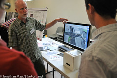
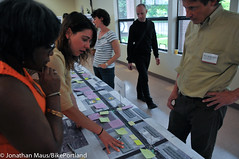
answers questions at the open house.
(Photos © J. Maus/BikePortland)
After 16 months and countless meetings, PBOT has revealed how they plan to improve bicycle access and traffic safety on N Williams Avenue. And much to the surprise of Stakeholder Advisory Committee (SAC) members, part of those plans include maintaining two full lanes for auto traffic in the busiest portion of the road.
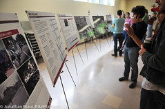
At the “final” open house for their North Williams Traffic Operations Safety Project, held Saturday at a church on Williams, PBOT rolled out new posterboards explaining the project, a 3-D simulation of the proposed changes, and they had project staff, SAC members, and traffic engineers on hand to answer questions.
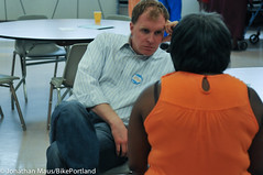
The event was well-attended, with a mix of people showing up to learn more and to leave feedback. In a nod to how political and important this project has become (Mayor Adams has been involved as have both former and current Oregon state representatives), mayoral candidate Jefferson Smith showed up. I noticed that he sat down and had conversations with SAC member Michelle DePass and SAC Chair Debora Hutchins.
As many of you know, the 26-member stakeholder advisory committee (SAC) for this project has played a major role in shaping the plans. After some neighborhood residents and activists spoke out with concerns of racial insensitivity, a lack of respect from PBOT for the neighborhood’s African American history, and an SAC that was not diverse enough; the City paused the project and added nine new faces to the committee.
Last month, the SAC made their final recommendation to PBOT. That recommendation included a left-side, buffered bike lane and one standard vehicle lane between Broadway and Killingsworth — except for one section between Fremont and Skidmore. In that busy commercial area*, the SAC recommended a “shared left‐turn lane/bikeway.” (*Note that removal of on-street auto parking to create more space for moving traffic was never really considered during this process.)
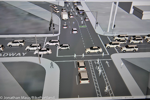
On Saturday, some members of the SAC were alarmed to find that PBOT had changed their recommendation and the designs they saw at the open house were not what they had agreed to. I’ll share more about that below. For now, let’s take a closer look at the proposed designs (thanks to Fat Pencil Studio for the simulations)…
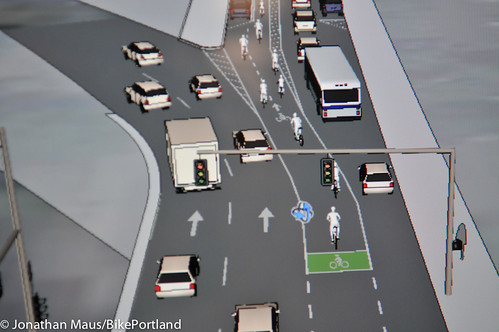
PBOT will begin to merge the bikeway over to the left just north of Weidler. As Williams approaches Broadway, a new, bike-only lane will between two standard lanes. The lane on the right of the bike lane will be for through traffic and the lane to the left will be for traffic entering I-5…
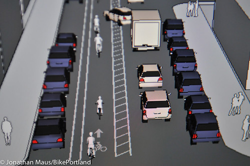
Just near the freeway entrance PBOT will include a passing lane in the bikeway that will merge into a seven-foot wide bike lane buffered from parked cars on the left (by a two-foot buffer) and moving traffic on the right (by a three-foot buffer)…
Here’s the cross-section showing the left-side buffered bike lane that will run from Broadway to just north of Fargo (except for around N Graham, which I’ve shared below this image)…
The buffered lane ends briefly at the intersection with Graham where the road splits between a median. At that point, we’re left with a standard bike lane (on the left of left-turning cars no less):
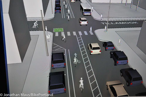
With much of the bike traffic on Williams Ave heading east (turning right), some folks have wondered how they will go from the left side of the street, across a lane of auto traffic, to turn right. There’s always the simple merge; but for folks that want help, PBOT has a design at intersections to facilitate crossing to the right. Here’s how it looks at Tillamook…
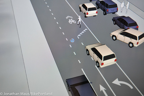
Leading up to Fargo, the design begins to transition away from the buffered bike lane configuration and into the shared environment. The markings to communicate this transition would include left-turn arrows and triangular yield strips just ahead of sharrows. Here’s an up-close look at it…
Then something interesting happened (and this is where things got a bit testy at the open house).
The SAC recommended that, after a transition area, the design should be a shared left turn lane/bikeway beginning at Fremont. But that’s not what PBOT brought to the open house. Instead, they showed a two standard lane configuration next to a standard (non-buffered) bike lane (essentially, exactly what we have now, just with bikes on the left side).
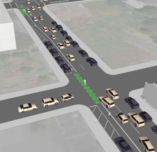
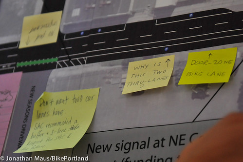
According to PBOT traffic engineer Rob Burchfield, they “refined” their previous traffic analysis (which showed one standard lane for the entirety of the project would be feasible) and came to the conclusion that two full standard lanes would be required between Cook and Fremont. Here’s how that block would look (Note: This is the block where the new New Seasons Market will be built):
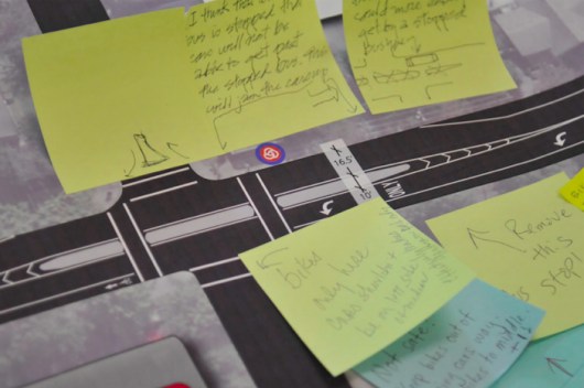
Suffice it to say, some folks — including SAC members — were not happy to see this design. And they were even less happy to see it revealed at the open house without any prior warning. Note the feedback via post-it notes in the photo below…
Here’s a closer look at the cross-section in the plans between Cook and Fremont (in addition to a half-block leading up to and after that section):
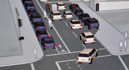
PBOT’s Rob Burchfield said the city feels two standard lanes are needed in this area to avoid auto congestion due of the volume of car traffic coming off the I-5 freeway onto Williams via Cook combined with all the new trips and auto circulation that is expected to come with the New Seasons Market on that block. Without two two lanes, the city feels, there won’t be enough green time in the traffic signals to “service the traffic” to the extent they feel comfortable with.
“I think we need to recognize, that with New Seasons coming, you’re going to get people circulating in and out of that intersection,” said Burchfield.
and Deborah Hutchins express concerns to
PBOT project manager Rich Newlands.
At the open house, PBOT project staff got an earful from SAC members and others. They wanted to know why PBOT decided to show this two standard lane configuration. “It doesn’t match up with our adopted stated outcomes for the project… This is not what we agreed to,” one of them pointed out to PBOT.
“Neither congestion nor parking is on the list of outcomes,” said another person looking at the plans, “and yet we have two lanes and parking on both sides of the street at the expense of having a safe bike facility throughout.”
It’s true. Of the top 10 outcomes adopted by the SAC for this project, none of them include maintaining a specific amount of capacity for autos (although, before the SAC even began to meet, the question of removing parking in this dense commercial area seemed to be, for some reason, off the table):
While some SAC members were flummoxed after seeing these designs, PBOT was open to their input and they are already planning to meet to iron out changes that need to be made. We’ll keep you posted on how/if the design changes.
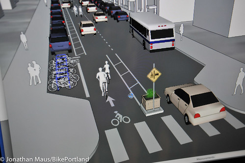
Beyond Fremont, the idea is to make it clear that the left lane is only for through bike traffic and left-turning auto traffic. To help drive that point home, PBOT will place a small median with a sign attached to it at the start of each block. Here’s an example (at Beech) where the shared left lane crosses a street…
And a close-up of the entry to the block…
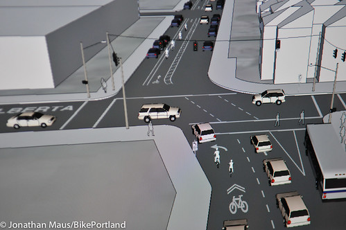
This shared environment will continue all the way up to N. Alberta, where the left-side buffered bike lane will return…
I hope that makes the plans a bit more clear. Of course, the devil is in the details on this one.
Since much of these plans rely on a buffered bike lane, a design that PBOT has acknowledged is not working as planned on SW Stark Street downtown, some people wonder how PBOT will make sure cars stay out of it here on Williams. Others are concerned about the shared-lane concept, and whether or not it will feel comfortable.
Open house attendee Emily Guise said she already avoids the busy commercial section of Williams because it’s “so stressful.” Her friend Erik Soltan said he doesn’t like the shared lane idea. “I don’t like the idea of being in a shared lane,” he said. In particular, he’s “nervous” about cars accessing the on-street parking on the left side of the shared lane. “They need to eliminate the left-hand parking, because cars will be cutting over the bike lane to get to it.”
Then there are the funding issues. PBOT currently has just $250,000 for this entire project. They could get to work on much of the lane reconfiguring with that budget, or they could add just one of the three signals asked for by the SAC. Hanging over that decision is that the request for signals is strongest among the area’s older residents and the lane reconfigurations would likely be seen as the thing most wanted by people who bike.
In other words, it could be politically risky if PBOT were to reconfigure the lanes first, and put off — once again — adding the new traffic signals that many in the community have been clamoring for for decades. On the other hand, PBOT and City Hall are feeling pressure from some corners to do something soon to improve traffic safety and better handle the crowded bike lane (after all, this project began 16 months ago).
Given the design details that still need to be worked out, the funding issues, and the politics around the project, unless more money can be identified (and the City now says they’ll apply for a federal Transportation Enhancement grant to help pay for it), I could see us waiting quite some time before anything moves forward. I hope I’m wrong.
If you missed the open house, please consider commenting on these designs to PBOT project manager Rich Newlands at rich.newlands@portlandoregon.gov. Stay tuned for updates.






Thanks for reading.
BikePortland has served this community with independent community journalism since 2005. We rely on subscriptions from readers like you to survive. Your financial support is vital in keeping this valuable resource alive and well.
Please subscribe today to strengthen and expand our work.
Please someone take away our Platinum rating. We do not deserve it.
Be easy y’all. Portland is the World’s beta site. We’ll get it worked out someday.
Here is my plea sent to Rich,
The current plan to develop North Williams raises concerns regarding safety and usability for both autos and bikes when approaching and navigating intersections, the problem of cars crossing the lane in order to park, the risk of door collision when loading and unloading a vehicle, and for the lack of consistency in standardized national design for cyclepath and road sharing.
The foreign design of the proposed plan will confuse local bicycle riders and drivers for some time, at the very least will be a source of frustration and at the worst cause deadly collisions.
Please redesign to encourage drivers and riders to share the roadway at reasonable speeds, keep the lanes open for everyone to navigate and respond to the dynamic of traffic, finally, please search for a standard design that will hold up over time and be recognizable and intuitive to even a first time user.
Sincerely,
Jake Cummings
andy@bikeleague.org is the email of Andy Clarke, Executive Director of the League of American Bicyclists. LAB isues the Platinum rating.
After seeing this, I hope they don’t find funding for the project. I would not feel safe riding this ‘improved’ street.
Put a parked car buffered bike line on the left of Williams like they have on SW Broadway!
Can anyone tell me why this common sense solution is not what PBOT came up with? They’ve already acknowledged that the buffered bike lane configuration above doesn’t work, and that most of the bike traffic will be turning right off Williams. I’m REALLY confused about why they chose the current design.
I agree… can anyone provide some links/info why this option was thrown out?
Not liking their design I had the same though and brought that up at the hearing. One of the PDOT folks told me they could not buffer the bike lane with parking like on SW Broadway because there are too many driveways that must cross the bike lane. When you think about it it makes sense. In order to safely turn out of a driveway a car would need to pull across the bike land to the edge of the parking to see oncoming traffic, effectively blocking the bike lane until they could turn. There are no driveways on SW Broadway. I still think there has to be a better plan than the one they presented. The shared bike lane/car turn lane feels like no bike lane at all.
If they can never do a separated bike facility because there are cross-streets, then we’re screwed, they might as well just go home, because we’re never going to progress from here.
What if we remove one parking spot from either side of the intersection (which would improve general visibility for people walking and driving, too), and then EXPECT people to pay attention when turning right (and hold them to it)?
I think it could work.
“If they can never do a separated bike facility because there are cross-streets, then we’re screwed…”
As far as I can tell, separated bike paths can only be made “safe” at intersections in a few ways:
a) Make cyclists stop/yield at driveways and cross streets
b) Put over/underpassess at crossings
c) Signalize the intersection and move the stop line back so drivers don’t need to creep across the bike path to see anything, and so that drivers aren’t turning right at the same time cyclists are going straight.
a) is already in widespread use, but is extremely undesirable for cyclists who find themselves stopping much more frequently than parallel auto traffic.
b) is too expensive and makes turns really hard.
c) is very expensive and requires that drivers never attempt a right on red at any such intersection, which is unacceptable for drivers. It is also highly unlikely to be employed at driveways.
If Cynical Me were to place any bets on which technique would get “tested” first on any new separated bike path, I’d go with a).
In the Netherlands, they make the cycle path and sidewalk continuous through the intersection, so that the person in the car, turning or crossing the road, has to go over a bump, which means they naturally slow down and look at what they’re doing.
I also tend to be fairly cynical about these things (they’re not giving us a lot of reason to think otherwise), but it wouldn’t take all that much brain work to do it well, it would just take some willingness to change the paradigm a little (and by that I don’t mean making painted bike lanes that go all over the road and disappear at some points).
Of course, that’s for a grade-separated cycle path, doing the parking separated one is different, but I think it would be reasonable to do it with the parking removed at the intersection, so that there is some buffer of visibility. I don’t know, it would certainly be better than the proposed option.
I suppose intersections could be handled somewhat like RR Crossings, where drivers stop behind and ahead of the tracks without ever stopping on them, but it doesn’t seem like the space used for parking-buffered lanes is enough for that.
Yes. No one is willing to give up the few on-street parking spots at the beginning/end of each street such a design requires.
16 months and they can only come up with a glorified bike lane painted down the street. Kudos PBOT, kudos…
Because it takes a lane away from cars.
I don’t think that’s true. Did it take a lane away on Broadway?
I think it has indeed to do with the loss of parking spots at the beginning and the end of each block. That would actually be a great way to accomplish their “increased visibility of pedestrians” goal (something that is much needed all over Portland).
What worries me the most is that by moving the bike lane to the left, cyclists are now jockeying for position with car drivers who are in “highway mode” – trying to make their way over to I-5 – not to speak of large commercial vehicles heading for the freeway.
I definitely hope that the reactions here will make PBOT reconsider the idea of a parked-car buffered bike lane on the right side, possibly with bike only-signals where it makes sense.
yes.
Part of the reason why the PSU cycle track works is that there are no right turning cars. It is basically a long a big T-intersection.
This is not the case on Williams. Cyclists are going to be hidden by the parked cars and will make the right hook probability much greater. Maybe making right hand turns illegal on Williams was part of that plan. Admittedly, the only time I will ever ride Williams is during non-rush hour times and it’s pretty much smooth sailing then as far as I’m concerned.
Have you even ridden the entire length? The terminus is a text book example of bad design: a wall of parked cars that hides the cyclist as they enter an intersection with right-turning vehicles (PSU students and staff).
Notice that I put *works* in italics. It is far from a perfect design and you are correct that it does end at a right hook trap. The point I was making is that you have several blocks that do not have the right hook hazard. With N. Williams it would not be the case–there would be several right-hook hazards.
I don’t know a single commuter who is happy with the “cycle track” on Broadway. After numerous near misses with kamikaze pedestrians and almost getting run down by a right hooking truck at the terminus I now just take the lane and avoid the entire mess.
I like it. There are the occasional absent minded pedestrians, but all in all it works pretty well, and allows for a quick ride past PSU.
What’s with the car pulling into the bike lane in the third image down?
For the most part it looks like a confusing mess. Well done, well done indeed.
That’s what happens when you have a long, drawn out, decision by committee process. Or: “if you try and please everyone, you’ll end up pleasing no one”.
I like committees to take their time and get it right – a “drawn out” process is fine if it produces a desired result. Having impatience for the process is understandable when it starts to take a long time. The problem of impatience is compounded when you have a drawn out process that results in a questionable result. This may be a decent example of, as you intimated, trying to please everyone. Some of that parking should probably go.
“What’s with the car pulling into the bike lane in the third image down?”
Looks like it’s going to park on the left of the bike lane. Reality might be worse than that rendering suggests, as normally one backs into parallel parking spaces, so the car would drive forward into the bike lane, stop, and back into the parking slot.
Since maintaining on street parking here and in other business/shopping districts in the city is vital, when is the city going to begin charging for these parking spots? If it’s so necessary and you just have to drive to businesses paying for parking shouldn’t be a big deal.
“…drive to these businesses…”
Quote fail.
And I totally agree.
Occupy the lane – NOW!
So disappointed that bikes will still be stuck between parked cars and moving cars – with or without a buffer zone. I was really hoping Williams would look more like SW Broadway at PSU.
This way, the bikes protect the parked cars.
Words cannot describe how terrible this plan is. But I am curious what role New Seasons ownership played in the decision to maintain two car lanes at its new location. They, like PBOT, talk a good game of bikes and sustainability, but they’re equally stuck in the car century, I think.
I have been watching and complaining as the flower vendor at the Seven Corners New Seasons store appropriates more and more of the bike parking spaces at that store, by my count at least 10 bike parking spaces have been either removed or taken over by the flower vendor without being replaced by store management.
Their right to do so, but clearly there has to be some economic repercussions if they choose to do so. It’s normally what business best responds to. Frankly your dollars are the best voting tools you have. The manager should know that the dollars gained from the additional flower space can be negated by lost business due to protest. The bike spaces were removed only after they assumed the money to be gained was worth the lost bike spaces. Unless people speak up they won’t be proven wrong.
Actually, they are required to maintain a minimum number of bike parking spaces per city code. I’m not sure what that number is, but I would assume that, if they were in compliance when they opened, the continued removal of bike parking spaces to accommodate the flower vendor has dropped them below the code compliance level.
Of course, this is one of the things that the BDS never follows up on once a business has received their occupancy permit.
are the flowers grown locally? the growing of ornamental flowers takes a lot of water that could otherwise be used for, y’know, keeping humans and animals and food crops alive. if these are imported from central america or wherever, new seasons should be ashamed.
I totally agree. The more I look at this the more I get worked up.
From article: “I think we need to recognize, that with New Seasons coming, you’re going to get people circulating in and out of that intersection,” said Burchfield.
With New Seasons coming, maybe we should think about not placing 4000 bicyclists a day between traffic and the driveway, what with all the people (read: motor vehicles) circulating in and out?
Am I missing something? If New Seasons is triggering greater traffic volume, should they not be required to provide additional volume (a lane) ? After all, they have a vacant site that could be narrowed. It is not unusual for jurisdictions to require this type of action.
That’s the way it’s supposed to work… new development triggers System Development Charges that are then used to pay for the impacts that development has on the transportation network. Unfortunately, PBOT says that the SDC pot it dried up and over-committed already to fund light rail and streetcar… which is yet another hidden impact that those extremely expensive rail projects have on our city and on providing a safe transportation system for everyone.
SDC or no SDC this a problem that they have created- it is New Seasons responsibility to solve it. Pulling the ‘money card’ is a refuge of fools. The money can be found. I am not aware of status of the land use approval for the project, but I certainly think, if possible, that the Planning Commission and City Council should withhold approval until PBOT solves this peak hour problem. Remember, this only a peak hour problem.
Don, why do you think New Seasons is not solving this? Are they responsible for all of the transportation impacts, or only their share of them? If they are the last one in, and are the “straw that broke the camel’s back,” are they responsible for all of the costs?
As you know, planning rules in this state are built around the concept as Jonathan describes it – you pay for growth through SDC’s, and the existing zoning is assumed to have adequate transportation capacity available to it. Otherwise, every development proposal that surfaces is subject to “highway” robbery.
Share the Road, Y’all.
Car-heads get what they demand; bike users are asked to share the leftovers.
Platinum leftovers, bro.
I’m fighting the urge to use a long string of expletives. This is just totally insane. This will be way more confusing and dangerous for everyone involved here. Just put in the traffic signals and leave it alone if this is the best thing you can come up with.
Again, we sacrifice *everything* on a project to car parking and automobile capacity, even against the decided-upon outcomes of the ENTIRE advisory committee (which, by the way, should point towards LESS automobile capacity). Maybe we do need to just wipe PBOT clean and start over. This is ridiculous.
They’re union. They’ll have you for lunch.
I am just flat out confused. I think I will continue up Greeley.
I’ve sent my thoughts to rich.newlands@portlandoregon.gov ! Thanks for posting the relevant contact information, Jonathan!
I did as well. There are so many reasonable thinkers in this town. I hope we can flood out this ridiculousness with some sense.
What a cluster. It would be better to leave this as is. This will be just like the Burnside – Couch rework- a total over-engineered mess. If this happens, and once accidents start happening every one who hasn’t followed this will ask ‘Why!?’. The city can’t make everyone happy all the time. At this point, let’s save the money and do nothing.
Um, I’ma just take one of the side roads like Rodney or Cleveland etc. Seems a lot safer.
No – Just ignore the pathetic “bike lane” and ride the center of the Right lane just like there were sharrows and speed bumps. There is enough bike traffic on Williams to just de-facto “take the lane” as a bike line. Drivers will just get used to it.
Now they gon give us the left hook. Turn the other cheek amirite.
Cool BMX track! Can we get some cool jumps over some alligator pits while we’re at it?
Jesus Christ. If this goes into place, I am finding another route. That stretch is stressful enough, this is lunacy.
I’m not confident at all that drivers would be able to handle a left-lane bike lane even in the best of conditions. This is so far removed from any other driving experience. I take N Williams up to Tillamook 99% of the time, and am not looking forward to merging right to take my right turn. This seems like a huge step back to me.
I will do two things—NEVER let my kids bike on this road and since it is my route home every night, i will continue to ride in the right lane and just let the cars deal with it. My safety would certainly not be any worse off.
This is fairly ridiculous. This is left hook heaven. Try and picture an out of state or even in-state driver hitting this stretch and knowing exactly what to do for all these intersections.
I would recommend the city/state/country hold off and standardize on a national plan for bike/car/ped traffic. This is a complete mess, it doesn’t match any other part of the city, let alone other cities that have done this previously.
Better to do nothing at this point and do it right later, than this half-assed mishmash attempt.
Portland has, for decades, spent a lot of time and effort to engineer their streets so that they are unpredictable. This is by design. Have you seen East Burnside? The street meanders left and right the entire length, to “calm drivers down” by making drivers feel psychologically in danger of hitting objects.
It does kinda work – East Burnside has low traffic speeds for its width – but I agree that this is an overworked piece of **** of a plan. PBOT should accept the SAC recommendation instead of using public/community process to “appease” the public and pretend like they care, because they obviously do not!
Fire the lot of them.
“Try and picture an out of state or even in-state driver hitting this stretch and knowing exactly what to do for all these intersections.”
Yes, but not just car drivers, bike riders, too.
The SAT answer format of this issue – ODOT:CRC::PBOT:Williams
Question: How long has the funding issue been known? Is the funding situation something everyone knew about from the start or was it part of PBOT’s surprise package?
I also hope they never find funding for this. We clearly require new leadership at PBOT before we end up with a whole slew of half-assed –not to mention straight-up dangerous– projects like this. We need some Janette Sadik-Kahn!
sadik-khan is always putting bike lanes on the left
Curbside bike lane ON THE RIGHT, parked cars to the left of that, car lane left of that, parking left of that. From Fremont to Cook where another auto lane is “needed,” eliminate the parking on the left. Done, and done. That’ll be $50,000.
This. Exactly this.
Nah man. Have you have been a victim of the Jackson St. Super Hook?
Share the Road. Educate people. Segregation is not the answer here.
sorry, I don’t type well when I’m angry. not mad at u, bro.
No offense taken Jake.
I think cars and bikes “sharing” the same roadway works OK on low-speed residential streets with sharrows. But this is a high-volume thru-street situation with mega-parking. Only aggressive cyclists will thrive here. Segregation in this case is a virtue. Think SW Broadway/PSU.
SW Broadway was easier and safer to negotiate before the cyclepath. Now, pedestrians casually walk across the path without looking, doors partially open into the lane. And Jackson St. at the end is a spot of confusion because the parked cars block visibility. You are asking for an alleyway.
And Jackson St. is at the end of the path on SW Broadway where cars and bikes have limited visibility. After having lived on that block for six years. I can tell you what was put in does not offer a safer option.
Holy crap, my proofreading. is so bad today
I’ve had no problems on SW Broadway, and cycle it daily. Liberal use of a bell helps to keep peds at bay. Oh the hordes of students invading my realm! I’d rather deal with them than a semi-truck or angry Washington cager any day.
I assume you aren’t turning left anywhere.
Don’t three rights make a left? 😉
Umm… Where do you see the bus-stops going? How do we meet one of the first requirements, Increasing the safety of pedestrians? Jumping off a bus into a channelized peloton of Cat-6 racers doesn’t sound like much fun to me.
How about, buses do their stopping in the auto lane. Bus stop waiting areas are on curbed islands that interrupt the right-hand parking and are connected to the sidewalk by mini-crosswalks for which bikes are legally required to stop.
Could be tweeked at spots, but is a cheaper, safer option.
Yikes. I’m all for innovative solutions, but that looks like a LOT of nonstandard designs and potential for confusion on the part of drivers. And confused drivers aren’t good for cyclists.
Especially going north from Broadway — to me the rightmost lane looks more like a parking lane than a traffic lane, and the width of the bike lane will probably invite people to drive on it. At a minimum, that bike lane needs better markings than just a green band across the front to tell drivers to KTFO it.
the only way I see those buffered lanes (anywhere in town) working is with an actual median or curb instead of paint. My guess is cost or fear of such a permanent change is why they are not done? OH wait not, it’s because of the parking… ah yes. =/
Buffered bike lanes with fading markings downtown do not make sense but the Holgate buffered bike lanes is a terrific facility.
At Alberta, bicycles will have to share a lane with cars at the only Northbound I-5 Access between the Rose Quarter and Rosa Parks. So now it’ll be passing stopped cars but instead of parked cars on the right, it will be moving cars negotiating a lane shift.
Good times ahead.
I already switched to Interstate. I’ll take the hill climb over that mess any day. Disappointed. I was cautiously optimistic but.. yuck. The learning curve for *everyone* to negotiate that will be fun…
I think its better the way it is than this bull$#*!. Now instead of trying not to get right hooked it will be right hook danger, left hook, right hook, merge with cars. Cars already have 3 minimum on this entire street. Why is 1 solid bike lane so difficult?
Facepalm.
They came up with a set of mission objectives and summarily ignored them.
Thanks Jonathan for such an in-depth explination of what is planned. I use this route frequently and am not impressed with what they have in the works. Painting a bunch of stuff on the road, from what I have seen, does not impress much upon car drivers. Stark is a classic example of this. Can’t blame them, up till recently all important traffic information has been up on signs where the driver’s eyes *should* be.
I watch cars every day park on the new streetcar tracks even though there are new stop lines painted on the road to prevent this. Good fun for them when the streetcar actually starts running. I don’t really see how this is going to be any different. New lines all over the road don’t really mean much unless it means actual damage will come to the car driver.
Since most of the traffic heading on Williams during peak commute hours seem to be sporting WA plates it seems unlikely that they are going to be interested in investing the time to understand Portland’s crazy antics about supporting bicyclists. They will instead be upset that they have to dodge bicyclists as they try and make their way north to the Alberta (or other) I-5 entrance. They are taking Williams after all to save some time.
Seems to me another street running N-S like NE Going St (bike boulevard) would be welcome over all this craziness on Williams.
signals or pavement markings? if it wasn’t for lawbreakers not yielding to pedestrians then they wouldn’t need signals to make the old folks feel safe…
however, the current legal way of bicycles passing bicycles via the motor vehicle lane is inconvenient and dangerous…
I’d suggest they put the money towards lane striping and dedicate a cop to writing tickets on that stretch for failure to yield to pedestrians… it should pay for itself…
I was hoping for a safer solution for my boys (Ages 6 and 9) for our weekend trips on Williams but this does not appear to be it. They should leave Williams as is and make Rodney a bike boulevard for families and those who prefer the slow lane.
AGREED!
Pretty sure I don’t understand how this meets any of the objectives, or improves the street for any of the users. If this is the alternative, I would rather just leave the street as it is and give the elderly their signal and maybe a couple speed bumps to help slow down the cars. Seems their unstated objective was really to lessen bike traffic by forcing them to all take different streets instead of Williams.
Over the course of this project, PBOT’s automobile traffic projections have been mentioned fairly regularly as one of the driving (*ahem*) factors behind how they are programming the roadway. A few questions\observations:
Question one: can PBOT’s motor vehicle projections be trusted? We’ve seen a fall in traffic volumes on I-5, despite the best projections of the traffic engineers working on the CRC, and a decrease in traffic volume in general. Do their calculations account for more pedestrian- and bicycle-oriented neighborhoods? Or do they assume that most of the traffic generated by new developments will be vehicular traffic?
Question two: have they projected bicycle traffic volume for this project? I have not seen it mentioned, although I may have missed it. Bike traffic on Williams/Vancouver has been increasing steadily over the last ten years, and it’s often too congested for the single bike lane, even as wide as it is in places. (I often ride Mississippi to avoid the mess on Williams, especially in good weather when there are more bikes on the road.) As more neighborhood greenways and other bike-friendly facilities come on line upstream of the couplet, won’t this just exacerbate the increasing bike congestion?
Question three: what’s wrong with a little north-bound car congestion at rush hour? It might help to dissuade some of those Vancouver commuters from using city streets as an alternative to I-5 if the “short cuts” are slower.
A way to refute PBOT’s motor vehicle numbers is to hire a traffic engineer and have him/her write a report that refutes PBOT’s numbers. If we had a functional BTA, that would be something for them to do. A functional BTA would also be vigorously opposed to this plan and already threatening a lawsuit.
how many people expressing their outgrage on this forum are also spending the time to write constructive feedback to PBOT?
Clearly the community on this board isn’t happy with the design so the only way to change it is to LET PBOT KNOW!
and how many showed up at any of the fourteen or fifteen SAC meetings over the last year plus? or at any of the public open houses?
The presentation strikes me as a 20 page tutorial which maybe bicyclists will pay attention to, but combustion drivers? This is a conspiracy to make bicyclists find another route. I will take the lane @ 15 mph every time.
Here is the letter I sent in:
Dear Rich and PBOT….I think you and PBOT staff should quickly provide answers on the North Williams road project.
I strongly oppose any left bike lane lacking a buffer. Your proposed buffer-free left side bike lane is far more dangerous than the current right side bike lane.
a) Help the public understand how your plan meets the 10 goals of the community advisory committee for this project.
b) Help the public understand why your staff delayed your input for 16 months of this project?
c) Help the public understand why 2 standard moving car lanes are needed? You’ve stated these are needed on Williams between Cook and Freemont. What volume are you describing? When and where are the sources of the congestion you’re describing?
rich.newlands@portlandoregon.gov
a) the left side bike lane is for the most part buffered
b) PBOT gave input early and repeatedly throughout the process
c) the only place you are seeing two full motor vehicle lanes is between cook and fremont. traffic count on that stretch of williams is about 10k, public record. adding in the new seasons is not going to reduce that count, nor will it relieve congestion.
early on there was a lot of talk about the problem of leapfrogging the buses. you can do it, and i can do it, but the “interested but concerned” do not believe they can do it, and tri-met is tired of fighting with people who can’t seem to get it right, so there was a consensus on the SAC to move everything to the left. new seasons was a kind of wild card here.
This 2 block section ( Cook St to Freemont ) is currently horrible.
Unless some parking is removed I see no way to allow these 3 factors to co-exisit in this messy 2 block section.
1) 405 exit ramp traffic
2) safety
3) New Seasons foot, bike and car customers
Here is my proposal. Anyone with word and paint skills can share their document too….
http://goo.gl/aox9a
URL above is a crude drawing. I’d like PBOT to do better.
your drawing seems to prevent cyclists from entering new seasons. as far as mitigating the 405 exit traffic, etc. the plan does show a stop light at cook. possibly the only element of the entire plan that will actually get implemented unless they find some money.
also your drawing would appear to preclude motorists exiting 405 from getting to the right lane to head east on fremont. of course, this may be your intention. making the exit at cook essentially useless for anyone heading east would have a dramatic effect on traffic volumes.
congrats PBOT for finding more creative ways to get cyclists run over in portland! your tireless efforts will not go unrewarded.
I’ll add my vote to those who will just ride in traffic in the right lane and avoid that over-engineered mess. I’m going about the same speed anyway at rush hour and I don’t mind the hostility. Water off a duck’s back…
I think it’s about time cyclists organized some sort of formal opposition to this plan.
If we spend enough money on meetings and design can we just get a bike overpass instead?
This is an overly complex, frightening mess. It clearly needs more thought. I have two suggestions:
1) Suck it up and remove parking from the left side of the street. With all the cars, bikes and busses it’s pretty hard to park on Williams anyway. There is plenty of parking on the side streets.
2) Install physical barriers to prevent left turns off of Williams at all but selected locations. Motor vehicles don’t need to turn left at EVERY street.
Make some real decisions, with real changes and we could have a real safety improvement.
PS. The parking needs of the churches are real. Why not simply designate the left motor vehicle lane for parking on Sundays?
precisely the problem, lack of leadership.
I want to say something snarky like, “Doesn’t PBOT realize that Eileen Brady is not going to be the Mayor?”, but I won’t. Instead, I will honesty try to say one nice thing about this proposal: At least the left-sided bike facility takes away the problem with playing “bus leapfrog”. That’s the only think it fixes, though.
First the Multnomah fiasco, now this. It looks like every little gain is going to be a huge fight from here on.
Nice work, PBOT! This makes riding through Beaverton look much simpler and safer by comparison.
Oh my god.
Just looked at the mock-up photos with this article.
Totally confused already, and I’m a bike nerd.
I wonder how on earth motorists will figure this out.
Yes, clearly a poor design. In the third drawing you can see the truck about to rear-end a left-turning (parking?) car right into your loved-one who is riding north. Crunch- Splat!
What the renderings do not show are the many, many signs that would accompany such a shameful design: “Yield to Bikes” “Bikes Merge Left” “No Right Turn” “Traffic Change Ahead” Arrows, Pictures, Share-Arrows, Things with lines through them… and all the poles to hold these signs up cluttering the right-of -way. Look for it;Bad road design is ALWAYS plastered over with “helpful” signage.
It’s going to be dicey trying to park your car, watching the cars you are parking between and at the same time having bikes rolling up on your right where you aren’t watching as well, I hope they stop for the car parking like they should.
What concerns me is that a new business planned at Fremont causes PBOT to redesign the street. How about instead PBOT keeps the street plans as they are, and tells the business they have to reduce their auto traffic generation so their excess traffic doesn’t screw up the intersection, or require them to make some other changes to make the street work (perhaps involving dedicating some land for more roadway width in front of their property, or paying for an added signal?)
I think this is a really, really legitimate point. When more AUTO capacity is anticipated, PBOT will bend over backwards to meet compliance.
But when more BIKE capacity is expected, they do absolutely nothing. Or just create a monumental mess, like this.
Why we couldn’t just have a cycletrack buffered by parked cars the whole way ala PSU Broadway I will NEVER understand.
What a convoluted mess.
There is some irony in New Seasons being used as an excuse to not build a better bike facility.
What a mess.
PBOT came up with this stinker of a plan just so we would forget about how they completely biffed on Multnomah. Great job, guys: it worked!