(Graphic: Trolley Trail Master Plan)
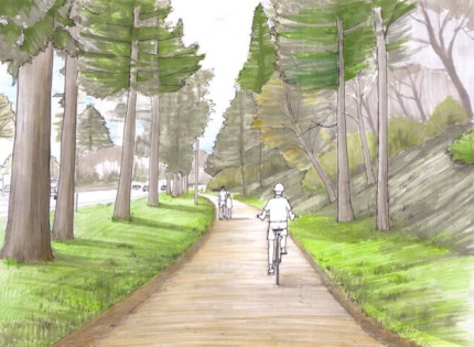
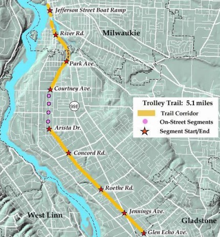
Officials in Clackamas have announced that they’re all set to break ground on the much-anticipated Trolley Trail project. The $4.2 million, six mile biking and walking trail will follow historic streetcar right of way connecting downtown Milwaukie with the city of Gladstone.
Matt Menely, a Milwaukie resident and small business owner who is active in transportation advocacy, says the Trolley Trail will have a huge impact. After I learned news of the groundbreaking today, I asked him to comment about the project…
“Once completed I feel that the Trolley Trail has the potential to become equal to the Springwater Trail in terms of its popularity and it’s ability to draw a diverse range of users. I’m hopeful that in the future we will be able to connect the North end of the Trolley Trail to the Springwater Trail with improved amenities for cyclists on existing roads, or ideally as a continuation of the Trolley Trail through Milwaukie in the form of a separated bike/pedestrian path.”
Here’s a map of the route…

The project is expected to take only nine months to build and work is expected to take place in segments. For construction updates and more background information on the trail, visit the official project website.


Thanks for reading.
BikePortland has served this community with independent community journalism since 2005. We rely on subscriptions from readers like you to survive. Your financial support is vital in keeping this valuable resource alive and well.
Please subscribe today to strengthen and expand our work.
Trails like this aren’t particularly useful for commuters. I ride River Rd and will continue to after the trail is built. On River Rd there are two intersections with four-way stop signs. On the trail there will be dozens of risky street crossings.
Sorry, Greg – I have to disagree. There are plenty of bike commuters who hate River Road, McLoughlin and Oatfield, and will be happy to ride the Trolley Trail, especially since it has the shallowest grade of any of those routes. It’s great to see them finally about to break ground – this has been a long-awaited project by anyone who lives near the Oatfield Hill.
I agree with Matt, River Road is unpleasant, even though it seems suburban/pastoral in parts, the cars still seem to travel at high rates of speed.
I tend to agree with Greg. Other than on its narrow, steep section near Oak Grove Blvd., River Rd. is a very pleasant ride — and will continue to be the faster commuter route. For more casual rides, however, I look forward to completion of the trolley trail.
I ride this trail end to end whenever I can. River Road is nice, the Gladstone trail is nice as well. They go to different places.
But trails like this encourage more to bike, and some of those eventually commute and more commuters make bike commuting safer and leads to more funding for bikes, and so it grows.
So they do help. It just takes a little time.
This is great news for cyclists and especially Milwaukie folk. Now all we need is access to the rail bridge between the River Rd. area and LO we could have a whole new world of cycling possibilities.
Wow!!! This is awesome. This means you will basically be able to get from the Eastbank Esplanade to downtown Oregon City mostly on offstreet bike paths (I couldn’t begin to guess at the percentage…Matt? Maybe 80%?) Throw up a few signs at the south end to connect to the 82nd Ave/205 Path bridge and you’re just about there.
exactly! that will be awesome!
Possibly more than 80% – There’s some off-street in OC itself as well, and actually, if you don’t mind mileage, you could go Springwater-Willamette to the main Springwater to I-205 bike path, cross the bike/ped-only bridge at High Rocks and ride about 500 feet of almost-no-traffic road to another MUP that goes through the park and spits you out onto a low-traffic road with bike lanes for the last 1/4 mile. There’s a tricky jog in Gladstone, but that also has bike lanes. (note that the route I’m describing here goes nowhere near the Trolley Trail – but that also opens up the possibility of a loop)
BTW, the “Sellwood Gap” of the Springwater is currently being constructed. The tracks have been moved, the gravel and wayfinding posts are laid and installed – all it needs now is pavement. Now is a good time to write the Milwaukie mayor and City Council and ask them to fix the bike lanes / shoulder on SE 17th Avenue. (the missing piece of that route) While you’re at it, ask them to please establish a bike/ped citizen’s advisory committee.
Milwaukie has some awesome planners like Katie Mangle and Brett Kelver working for them in Transportation, but what it really needs right now are citizens to motivate the Mayor and Council to pay more attention to Active Transportation issues.
Oh, and with Milwaukie Light Rail, people all over metro Portland will be able to take MAX to the start of the Trolley Trail and ride it – and vice-versa. In fact, with the terminus at Park Ave, I can’t imagine why anyone commuting from far south would take River Rd again unless biking the whole way, since the Trolley Trail will take them straight to the MAX stop without having to deal with 99E.
If anything will get more people riding bikes, it’s increasing the number of grade-separated facilities like this one. Glad to see this link in the system coming to fruition!
Wow, what a great trail this will be. I’d love it if it could be more clearly connected to the Springwater Corridor. It looks like the easiest connection will be along 17th Avenue from Sellwood. Hopefully the county can include signage and some infrastructure improvements to make that happen. And same thing for the I-205 path. That would help make a pretty decent loop.
SE 17th and SE Main will be the easiest connections. Main is a low-traffic arterial leading straight into downtown and has a fairly easy access to the Springwater on the east side of the bridge over McLoughlin (99E).
I’ve already been tempted to ride this as a gravel trail. It’ll be great when it’s paved.
We need as many offstreet paths as we can get. Great for attracting new riders, riding in groups, taking your kids, relaxing.
They’re slowly but surely getting interconnected and better for commuting. The Gresham-Fairview trail is now open from the Springwater to 201st at Halsey. Not sure when but it will later connect to the i84 path, Marine Drive close to Blue Lake.
Great story and information. How about an update on the Gresham-Fairview Trail?
Oh crap, did I miss the window to ride it BEFORE they pave it?
After all, in Portland’s bike culture DIRT=BAD.
I’m (mostly) kidding. This will be (and is) a great addition to our infrastructure.
Awesome news!
I also happen to agree with GlowBoy, however. When are the dirt trails coming?
When next riding on the I205 path, the Springwater, etc, take notice of the margins on either side of the pavement and consider this idea: In the margins along these off-street trails, why not build a 12″ singletrack that parallels the paved? It could meander to and fro along the pavement to take advantage of gradient changes and create an exciting, technical riding experience right in town. If we were to do something along these lines, these facilities can be made to accomodate nearly everyone, while not requiring any more land than what is alread available. …And doubtful any organizations would lobby hard against this. (e.g. friends of forest park, cough)
But if they did that it would cost $8.4 million instead of $4.2 mil! 😉
I see the humor but seriously.
In the artist’s rendition that heads this story, picture a singletrack to the right of the paved trail. The Singletrack can roughly parallel the paved trail while, at the same time, climbing and descending the hillside depicted on the right. ….Weaving in and out of the trees, etc. There are miles and miles of Springwater/I205/Columbia Slough, etc of off-street trails that would lend themselves well to this model.
If this model were followed, folks on mt. bikes would have a better go at accessing the Gateway Green area when it gets developed. …Without driving there.
Material cost = $0
Labor cost = Partner with the NWTA and I bet you’d have a flood of volunteer labor.
I love bikes of every stripe but Mt. Biking is closest to my heart. While I love to see the development that Portland commits to bicycling, consideration for off-road cycling is absent from most of these developments. …Pity.
DK – unfortunately, the hillside is all private property. The Trolley Trail has a lot of constrained and shared right-of-way (ROW) issues, which is a major part of why it’s taken 10 years to get to this point. (the other major part being funding) It would be great to have more singletrack, but the Oak Grove area has nowhere to support it.
I guess I just have a different perspective than most. When I’m commuting I like to get up to speed and roll for long distances without stopping. When I ride paths, like the Springwater headed east, it seems like every time I get up to speed I have to slow to a near stop and look for cross traffic, then accelerate back up to speed, repeat. Those crossing worry me. They are excellent places to get t-boned. Plus it adds significant time to the commute. Don’t get me wrong, though. I’m sure the path will be great for local residents riding recreationally with the kiddos and folks walking their dogs and strollers. It just isn’t my idea of a good transportation route if I’m going any distance.
I think the addition of singletrack would be excellent. I’m all for that. My comment was meant to ridicule the proposed cost of the *paved* trail. $700,000/mile? Sheesh. I’d do it for $500,000/mile.
Most of that cost was land acquisition. The area is close to 99E, and land costs were also affected by Trimet’s advertised route for Milwaukie Light Rail.
Who did they have to buy the land from? I thought it was all trolley right of way allready owned by govt.?
How much does it cost to lay down a strip of asphalt?
Jonathan, Thanks for posting this story!
I’d like to add that folks who want a little adventure should go ride this trail now, before it is built, to get some dirt under your tires. It is a fun, exploratory ride as it stands, if you are up for a little bit of route finding (because there are not a lot of signs).
For the faster cyclists, the project might be able to be improved if some stop signs could get flipped to allow cyclists more flow. If that sounds like an improvement you’d like to see, contact the county and talk with them about it.
Matt Picio is right, there is no available space (ROW) to place any single track in this area.
One other benefit of this project that may not have been mentioned enough is that there are multiple schools along this route. Many students will have a safer, off-street route to and from school.
We all need to keep in mind that each of us has our particular style of riding we prefer (single track, fast,….) , but to move cycling forward as a whole, we should all support projects which aim to get more people on bikes in a safe and healthy manner- regardless of our own personal preferences.
Cool This wasn’t on my radar, looks ilke a great project. Basically extending Springwater on the Willamette down most of the way to Oregon City. With a few gaps, kinda like the Springwater itself.
Thanks to all the planners, bureaucrats, elected officials and citizen activists that have made this happen!
Ted Buehler