The Springwater Trail Repaving Project has begun and so have the closures we warned you about back in March. Since our last update, Portland Parks has released updated detour and closure information (which I’ve posted below).
To recap, this project is funded by a $1.8 million grant from the American Recovery and Reinvestment Act (ARRA, a.k.a. the stimulus bill). The money will pay for repaving eight miles of trail and it’s set for completion by the end of August.
The trail will be closed in four separate sections and the Parks Department has been kind enough to color code them for us. Detour details and scheduled closures are listed below…
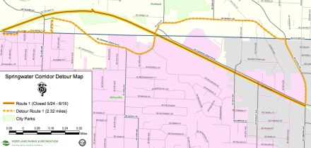
The Orange Route: The trail segment closure from SE 28 Ave to Linwood is scheduled May 24-June 15.
- Exit trail at SE 28 Ave. Follow detour east via Sherrett to SE 33 Ave; north to Johnson Creek Blvd; east to SE 45 Ave & Harney Dr; east to Flavel Dr; south to rejoin trail at Johnson Creek Blvd/Flavel intersection.
The Blue Route: The trail segment closure from I-205 to SE 128 Ave is scheduled June 8-July 6.
-
Exit trail at I-205 bike path. Follow detour north to Harold; east to SE 128 Ave; south to rejoin trail.
The Green Route: The trail segment closure from Linwood to I-205 is scheduled June 16-29.
- Exit trail at Flavel Dr. Follow detour north to Alberta Ave; east to SE 72 Ave; north to Flavel St; east to I-205 bike path; north to rejoin trail at intersection with I-205 bike path. Green Route Detour Map
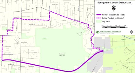
The Purple Route: The trail segment closure from SE 128 Ave to Jenne Rd is scheduled June 30-July 23.
- Exit trail at SE 128 Ave. Follow detour north to Holgate Blvd; east to SE 130 Ave; north to Cora; east to SE 132 Ave; north to Bush; east to SE 148 Ave; north to Powell Blvd; east to Naegeli; south to Powell Butte Pkwy; south to Circle Ave; east to rejoin trail at SE 174 Ave & Jenne Rd. Purple Route Detour Map
Some of these detours look pretty crazy — especially the ones further out east. If you ride one of them, please let us know how the detours work out for you. I know the City would love to hear your feedback.
Check out the Springwater Trail Repaving Project website for more information.
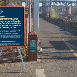
And in related news… The Springwater is set for another closure next summer when a project to enhance and improve the 170-acre Oaks Bottom Wildlife Refuge could close the trail for up to four months.





Thanks for reading.
BikePortland has served this community with independent community journalism since 2005. We rely on subscriptions from readers like you to survive. Your financial support is vital in keeping this valuable resource alive and well.
Please subscribe today to strengthen and expand our work.
Sheesh. Some of those detours are not appropriate for the kind of recreational riders that use the Springwater in summer. I realize the options are few, but I would not want a young child riding on SE Powell between 148th and 166th — that would be scary as hell.
For the non-regular cyclist, the Springwater (as a true transportation corridor) is off limits much of the summer. Or, at least, those folks are going to have to expect to either turn back or risk getting lost in outer SE PDX. I hope the signage is excellent for the detours…not sure I would trust my knowledge of the streets out there.
Maybe they should warn people that the detours are on some high-traffic streets — not the same as riding the trail.
If my memory serves me correct, one better be in great shape or at least have a triple when that “green” route closes as that hill on Flavel Rd looks nasty.
Makes me wish i had a crotch rocket, thinking about getting up that hill. hahahahaha. No seriously, that’s a tough one. A homeless man once jumped right in front of this biker in front of me once here, and we all barely avoided a collision. I volunteer at shelters on holidays, but i still have hard time when a homeless person, male or female, drunk or sober, naked or clothed, rushes out onto bikepaths and almost cause us injury. Once, I almost ran over a cat, but i don’t expect cats to know better. Sorry to be disrespectful, but all the recent talk about signage and policing has gotten me “frazzled.” peace to you.
FYI, the second PDF link is pointing to the same file as the first link.
The Springwater is our Freeway. Yet parts of the route are fully closed. Why can’t the route be redone, as Freeways are, with one lane closed and one lane open. Get some flagers in there I have to get to work and this in MY Freeway!
cyc, it ain’t your freeway anymore, pal.
Yes, it’s a hassle for a while, but I for one am looking forward to riding a much improved surface. Thanks for the rework, Portland parks!
what the Gresham end of the trail isnt worthy of repaving. once again the far east crowd gets left out on bike improvements. guess they think we dont ride out here.
Yeah that hill at Flavel Dr/Linwood is pretty nasty, and will be difficult for a lot of people. At the end of the day, the Springwater won’t really be available for the same sorts of recreational activities when the different sections are closed, but it seems that each section should only be closed a couple weeks at a time, so people looking to walk a couple miles with their strollers, or run a little bit won’t be greatly impacted as I see it. The main impact is for those who use it as a commuting route, but the benefits of repaving for them will be well worth the hassle of the detours in the meantime.
For those looking to bypass the hill at Flavel, you could take Johnson Creek or SE Alberta between Flavel and Bell, depending on whether you want to end up at the bottom or top of the hill. Bell has a bike lane and is a much more manageable grade, SE Alberta is not very heavy with traffic, and Johnson Creek has a shoulder though often traffic moving at speed. If you’re commuting from east of 205 to downtown, I would recommend finding a route that bypasses all these silly detours altogether, likely a busy street with a bike lane, such as Powell or Foster (to Woodstock), Division or Burnside and then connect to other bike boulevards or typical routes as you come in closer from SE.
At the end of the day, this project needs to get done and it’s great to see the time and money spent to do it. Is it an inconvenience? Certainly, but these are the things life makes us deal with.
Glad this is finally getting done. Then I can get all my fillings replaced.
They’re just dumping 2″ of asphalt over the top. Hopefully it’ll last.
Linwood is not “nasty” it is steep, certainly steeper than the graded interurban path. Please reserve the word NASTY for things like riding through fresh dog poo with no fenders, crashing at speed and scratching all the skin off your hip and knee and elbow, finding fungal matter in your water bottle.
So…..I wonder how all this will affect the homeless, er, hiker/biker campers, er, indigenous population along the trail….
djfusion, the last time I rode through Gresham on Springwater, I remember how much better the surface was than it is along points west, the parts that are getting improvements. Has that changed? Maybe they aren’t repaving the Gresham end of the trail because it doesn’t need it?
When was the last time the ST was completely open and not under construction?
Justin,
When the trains were still running.
Portland Parks is paving the trail because it is rough as a cob and as a response to complaints from cyclists. They have staged the work so that at any given time most of the trail is open for use, and provided detours on the nearest surface streets available.
Most of the responses on this thread are yet more complaints. Sheesh people, don’t feed the misconception that cyclists as elitists with delusions of entitlement.
Gresham is in much better shape.
1. They used better quality asphalt.
2. They appear to have worked the old road bed to ensure that the compaction from the ties did not telegraph through the asphalt.
The Portland section of this trail has been in worse shape than the Gresham section since it was built.
+1 for comments by resopmok (#9) and Bob_M (#14).
I ride the Springwater regularly, and the work is necessary. These detours are appropriate in this situation and the results will certainly improve the ride.
Rather than repave what’s already there, why not extend the trail on out to Boring?
Glad to see it is getting a makeover. Ready and excited.
But….I’m still hoping that the trail gets paved all the way to boring.
Why is there no talk of how NON-green asphalt is……..it is made from the bottom of a barrel of oil, which comes from the same source that is polluting the Gulf of Mexico right now…….think about that as we all feel proud ‘being green’ as we pedal along these asphalt paved pathways. And just what kind of fossil fueled equipment is used to manufacture it, bring it to the worksite AND lay it down so smoothly? And then there is the runoff from the ever present rains. More food for those green thoughts. Enjoy your ride!
My suggestion: natural surface trails…..
Three letters for you RWL1776: ADA.
RWL1776:
This is the same argument I saw on Bike Snob’s blog the other day, when people were saying that moving something like 4,000 lbs of tile by car was bad for the environment and it should have been done by bike.
My question is this: where does it end?
You can keep trying to go greener and greener and greener, but you will quickly hit a point of diminishing returns where it just isn’t worth it.
The computer you’re accessing this site on is made from petro-chemicals, silicon, lead, nickle, aluminum, gold, and many other products that are mined in ways that harm the earth. The production process for electronics is hardly clean.
The electricity you’re using is powered by a combination of hydro (killing the fish!), wind (killing the birds and the view!), and coal-fired plants (releasing tons of CO2 and trace radioactive elements when burned).
Where does it end? Can’t you use a more green way to access this site?
Complaining about a bike path not being green enough just seems so counter-productive in the grand scheme of things. At least people are RIDING on the path, and not driving somewhere else.
I tried to talk to RWL1776 the other day on a ride, but found it impossible over the noise of his bike. He really needs to lube that thing.
This is a waste of time and money IMO. …And it closes one of the busiest off-street bikeways in the whole city during the best cycling months of the year!
While there are some spots on the Springwater that could use a little love, I’d much rather see the money go elsewhere in the city to develop NEW bikeways that will give cyclists MORE options to get around our fair city in a safe and timely manner. If it absolutely must be the Springwater, why not add paved miles East of Gresham where there’s currently just a gravel pathway?
We can do a lot with $1.8million. Let’s think about this a bit, eh?
How can Portland lay claim to being a platinum-level bike friendly city? After this project is done, where are people who want to ride on a trail with a crappy worn-down asphalt surface going to ride? All of the bike funding in this city goes to pro-petrochemical projects that result in smooth and safe riding surfaces. What an outrage.
And shame on the commenters that suggest that we pave over some of the precious few remaining miles of the Springwater Trail that are graveled. I cherish being able to ride to degraded railroad trails in the city so I don’t have to drive to them!
With projects like this it is no wonder that Minneapolis is ahead of us. We need to have facilities in the city for ALL types of riders!
And blah blah blah….
I am crazy excited for this project to be done!
Yay! Finally, some parts of the trail are really rough. Yes, the closure will be inconvenient. I ride from St. Johns to my job at SE Foster and 112th, so I’ll probably use the 205 path for a while.
Here’s the link to the 2nd stage of repaving Map #2
Are they re-paving the section between 82nd and 92nd? That stretch was paved a few years ago through some private fundraising and is still the smoothest stretch of the entire Springwater.
Construction information and detour routes have been added to the OpenStreetMap.org data and should start appearing on garmin.na1400.info, opencyclemap.org, etc within a few days.
The only really true way to limit your carbon footprint is to kill yourself. So…let’s get started!
Sheesh…I wonder if they would make drivers go that far out of their way to traverse a workzone…?
But at least the detour route will be sweet – and as safe and comfortable to ride as the trail. (I hope.)
No, that hill at Flavel is nasty. It’s too bad that they don’t think Johnson Creek is a viable alternative. Couldn’t some temporary striping/signage be put in place?
MeghanH @1:
Powell isn’t as bad as Division (no curbside parking on Powell – heck, no curbs!), but you can cut the distance on Powell in half by turning right (south) on 148th, instead of left. Turn left on Gladstone. At 154th you have the option of going left to Powell, or continuing straight on Gladstone and taking the sidewalk on the north side of the street where the street dead-ends. There is a walkway through to the mobile home park, and use its streets to get back to Powell around 158th. From there you have no choice but Powell, but there are only a couple of cross streets to deal with before you reach Naegeli.
For the closure along Johnson Creek Blvd, I’d suggest:
Turn Left at SE 45th Place
Bear right up the hill at SE Harney
Turn left on SE 72nd
Turn right on SE Flavel Ave. (very wide bike lane)
Turn left onto the Springwater at SE 86th
I suppose it depends where you’re headed if you can cut all that out, but going up or down Flavel Drive (not Flavel Ave.) at Johnson Creek will definitely race your pulse.