(Photo: PBOT)
This morning, Portland City Council formally accepted a $1.3 million grant for the 50s Bikeway, a project that was first identified as a priority in Portland’s 1996 Bike Master Plan. Today’s acceptance of the grant is a procedural formality (technically, it’s the signing of an Inter-Governmental Agreement between PBOT and the Oregon Department of Transportation), but it also allows PBOT to begin the final planning and outreach stages of the project.
Once complete, the 50s Bikeway will be a 6.7 mile mix of bike lanes (some exist already) and bike boulevard treatments (like medians and other traffic calming elements). The planned route begins in Northeast Portland at 57th and Thompson and goes south on 53rd Avenue to cross I-84. The route then jogs to 52nd and continues south to Woodstock Blvd.
At the route’s southern terminus, people could connect to the Springwater Trail via bike lanes on SE Woodstock or on Harney Drive (to the south). In addition to new bike lanes and other traffic calming features, the project will include improved crossings to aid people trying to cross major arterial streets like Burnside.
The project was identified in the 1996 bike plan but it wasn’t until June 2006 that the Portland Bureau of Transportation (PBOT) applied for federal funding through the Metropolitan Transportation Improvement Program. The grant was awarded a year later. PBOT project manager Rich Newlands told me this morning that they’ve been waiting for federal funds to “come live” before proceeding. According to Newlands, here’s how the project schedule plays out from here.
In about six weeks PBOT will get an official “notice to proceed.” Then, in April they’ll start a public involvement process that will run through this summer. That “project refinement phase” will likely end in late summer and Newlands says the project could start construction before the end of next year.

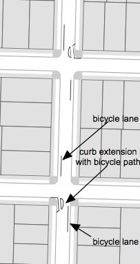
are being considered as a way
to calm traffic on 52nd.
(Graphic: PBOT)
According to the grant application written by PBOT bike coordinator Roger Geller, the goal for the 50s bikeway is to reduce motor vehicle speeds and volume. To do that they’ll use a “range of techniques” including bike boxes, shared-lane markings (a.k.a. sharrows), way-finding signs, and so on. Here’s an excerpt from the grant application:
“On the bicycle boulevard segments of this project, we will use a full range of techniques designed to create world-class, low-traffic volume, low-traffic speed bicycle boulevards… We will fully investigate conditions throughout these corridors and add additional traffic calming, as needed in order to bring speeds as low as we allowably can.”
Also according to the grant application, the most significant design element of the bike boulevard portion of the project will be the creation of “chicanes to create queuing conditions for motorists at alternating intersections, while allowing unimpeded passage for cyclists.” You can see a drawing of that design on the right.
PBOT says chicane treatment “…. will secure priority for bicycles on the boulevard segments of the street, dramatically slow traffic, and divert some existing traffic, without denying access to the street for motorists.”
Newlands says all these design ideas will be put in front of the public for feedback during the outreach process. Stay tuned for ways you can chime in.


Thanks for reading.
BikePortland has served this community with independent community journalism since 2005. We rely on subscriptions from readers like you to survive. Your financial support is vital in keeping this valuable resource alive and well.
Please subscribe today to strengthen and expand our work.
I just recently noticed a curb extension like that on 11th and Clay, near Ladd Avenue, and figured it was for something like this. I actually think that could be really useful, potentially, though I hope the width of the gap in these curb extensions is a little wider if they want it to not bottleneck cyclists – if it’s the same as the one on 11th and Clay, it’s going to slow down cyclists, and only allow them to pass 1 at a time.
..continues south “to” Woodstock.
I’m happy for this project. Good Luck.
Further clarification about the route to go with RyNO Dan’s comment. Since Woodstock Blvd. runs east/west it is basically parallel to the Springwater Corridor, so you’d have a hard time getting to the Springwater if you stayed on Woodstock. What you can do is to continue south on 52nd to hook up with the Springwater just south of Johnson Creek Blvd.(after a right turn (to go west) on Harney at the bottom of the hill). 45th also connects easily to the Springwater and is the way I usually get there.
Going east on Harney is not particularly useful, since it is basically discontinuous around 58th and it doesn’t cross the Springwater until it’s almost to 82nd Ave.
Apart from the glitches in directions, I’m glad to see this project get going. I hope mapping clarifications were helpful.
Dan and Dougonabike,
thanks for catching those errors. I’ve made some edits and I hope it’s all clear now.
From that diagram, I have no idea how the “chicane” treatment is supposed to work. Looks like it would force cars into the bicycle lanes. I must be missing something.
Anything that could make both Woodstock Blvd. and 52nd Ave. safer for cyclists is an improvement I can get behind. I live just off Woodstock but rarely bike that street. The bike lanes are okay, but the traffic moves so fast on the street that even crossing Woodstock is dicey. I’m even more intrigued about how 52nd will change, as it’s not a very wide street to begin with, and is currently dangerous for cyclists. I’ll reserve other comments until we actually see something in the “outreach process”.
Thanks, dougonabike. I was going to write something hurtful, but I hit F5 instead.
Oh, and what does 50s refer to? I’m thinking 1950s everytime I see that in the article.
Finally! Part of the reason I bought my house near Woodstock and 52nd Ave was the anticipation of this project. Between Powell and Woodstock, 52nd and its approaches need a lot of help. Thanks for your coverage.
As another person who lives near woodstock and 52nd I say hooray! if anything helps to reduce the sheer number of cars on 52nd it will help – i’m looking forward to being able to sit on my porch and hear myself think over the oppressive din of the constant stream of motor vehicles (and that one guy on a scooter that wakes me up every night at midnight).
Personally I vote for Foster Blvd. and Sandy Blvd. first. Consult a map of the city to see why.
I know people here want the cars to go away, but you have 82nd, 52nd, Cesar Chavez, and McLoughlin, and maybe Milwaukie/12th that go anywhere. Why not leave these for the cars and commandeer 72nd for bikes? Won’t making 52nd an obstacle course for cars just push more traffic onto Chavez? My feel right now is that 82nd is too small, and that Chavez and 52nd are about right for cars. The trend is for fewer cars, but I do not think it will be drastically fewer in the near term.
I am a little worried about curb extensions with bike path – are they wide enough for bikes with trailers or long bikes? How are they going to be lighted?
I am cycling on the re-done Clay street and sometimes on Lincoln and find the curb extension are hard to see in twilight.
I always thought that both woodstock and 52nd were very nice to ride. There may be a lot of cars, but both roads are wide enough to accommodate a cyclist and a car side by side comfortably.
I used to ride both to work daily.
Considering just the Woodstock neighborhood, I feel what is truly needed is another east-west street paved all the way through. Nothing’s continuously paved between 40th and 52nd south of Woodstock until you hit Rural.
I think paving Tolman would be great. Even if it’s just a strip of asphalt 10 feet wide.
Hey! Another north-south route with stop signs every other block that ultimately feeds you onto a scary, high speed, heavy traffic east-west to get where your job is. Platinum thinking!
I’ll be cheering this project on from my front porch. I’m on 52nd, just south of where the route shifts over from 53rd. This is really good to see.
Certainly this plan is far preferable to that other vision the city had for this particular stretch, long, long ago:
http://bikeportland.org/2009/02/16/picture-of-the-week-the-portland-that-might-have-been/
I just hope nobody wants to improve the bumpy concrete surface of this stretch of 52nd. Hard to say for sure, but the bumpiness seems to provide some degree of traffic calming.
Spencer,
Agreed that the bumpyness of your stretch of 52nd is a calming influence. Perhaps you can get the folks on the corner at Halsey to park a larger SUV there.
Perhaps you could get the entire street north of Halsey to park cars on the street in a staggard fashion ie. east side, west side and all as far from the curb as possible.
astro
I wish to second the version of reality presented by Jacob(#13). I have commuted most of SE 52nd (weather permitting) with an eight-year-old on the back of our tandem from Burnside down into the loveliness of Milwaukie since September. This is a wide, slow moving traffic corridor which I find mostly occupied by other parents bringing their children to school, a fair (and consistent regardless of weather) number of bicyclists and only a few folks hell bent on heading out to The Glory Of The Clackamas Town Center via Flavel Road, with all the urgency that such a destination requires.
I’m expecting to commute to Milwaukie on this route for the next ten years by bicycle and I’m happy with the way it presently is.
But of course…As I have seen over the past four to five years, traffic patterns will change.
astro, I’m on a whole different stretch of 52nd, not particularly close to Halsey. So I’m afraid you lost me there; not sure what’s up with the suv issue.
So, Jonathan – the real question is, since this project is MTIP-approved, and has a concrete funding source and looks to be a go – does that mean that Portland Streetcar is no longer looking to use that route as a N-S corridor? Or are we going to have to contend with streetcar tracks, plus deal with Streetcar construction after this project is completed?
It’s great that this project was approved – I applaud the city and look forward to the public process, and to seeing the city fix some of the current troublesome spots where the 52nd corridor intersects Sandy, Halsey, and others. Traffic calming will make the area safer until car traffic volumes start to decrease.
Matt Picio,
that’s a good question. I’m not sure about how streetcar plays into this (perhaps Chris Smith can chime in?), but my hunch is that streetcar is far enough away that it’s not something of concern yet to PBOT planners.
Good to see more bike infrastructure going in, but when will we focus on improving the east-west route to Downtown Portland west of 82nd? Springwater puts one into Selwood; Marine Drive puts one into St Johns; Nothing puts one into Downtown Portland – unless the Sullivan Gulch Trail becomes more of a priority. It appears that it is approximately 10 years off into the future. What are the best ideas of the safest route today from 82nd into Downtown?
I think this is great- 52 is already my favorite way to get to the springwater (and its 10 blocks from my house) and once they fixed that rut just south of woodstock and 52 it was pretty easy biking because it is wide enough to let cars pass without getting close.
I am all for more improvements (does that make me an IMBY?) but arent there ather areas that need this more?
Why 52nd? It is pretty busy and a better alternative to crater-sized potholes, no sidewalks and prostitutes infested 82nd.
Expect quick passes on the right into the bike lanes … I do it all the time rather than wait for a left turning vehicle in the middle.
Move the damn bike boulevard on 51st or 50th!
The crossing on Holgate (by The Hutch pizza joint) is the most yucky part of my commute home to 52nd and Harold.
Combining the lane in the middle for bikes ala’ Division style, and a light like the crossing on Hawthorne and 42nd should fix that.
I heard there was once a road that went directly across before the business moved in… so that jog was not required…”used” to be there? Curious about whether we might be able to work that in again too?
Crossing Powell on this common bike route via 42nd is also a less than comforting experience. Some bike boxes on either side of Powell and a middle lane might be the best means to create safer crossing.
I hope the crossings at Powell will be safer on all commonly used parts… 26th, 39th, 52nd will receive some attention.
So glad that 52nd is receiving bike lanes. The mornings are especially sketch as cars are racing on and out of streets off the side and moving quickly down to Powell and beyond all the time.
So glad to see improvements heading N.
Our biggest complaint besides some little areas here and there heading downtown, have been the N. to S.
The idea to add a small bike road from W. to E. 40th to 52nd as mentioned by Schroader, sounds good too.
Tolman is a well used bike route from W. locations and the roads are in very poor shape.
Those unimproved roads could be a combination of bike routes, pocket parks, exercise spots, dog agility courses, pocket gardens/community gardens (okay, I am getting off topic;)
A Google walk route between the end points of 57th & Thompson and 52nd and Woodstock is 4.4 miles long. Where are the other 2.3 miles being inserted in this route?
I concur with comments #23 and #18 – 52nd is wide enough (at least from Woodstock to Division) that bikes and cars can co-exist. This is part of my daily commute.
Good going on the 52nd route. We need to make the E-W Sullivan’s Gulch Trail a priority!
82nd to downtown? woodard to clinton through Ladds to Hawthorne Bridge is How I would do it.
For those looking for more information on the 50s bikeway project, I found more information here, some of which seems to be as recent as August 2010:
http://www.portlandonline.com/transportation/index.cfm?a=305344&c=35953