The (very) long-awaited bike and pedestrian improvements to the Morrison Bridge will begin construction next week.
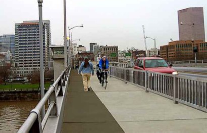
In the plans are a 15-foot wide shared path that will be added (only) to the south side of the bridge (it will be a two-way facility), from SW Alder Street to SW Naito Parkway on west side and SE Water Ave. on the east side. This $1.9 million project will vastly improve biking conditions on this bridge. Currently, the Morrison has only five-foot sidewalks (even narrower at pinch points) on each side.
According to Multnomah County, the Morrison Bridge has the lowest rates of bike use of the five downtown bridges. For comparison, the most popular bike bridge, the Hawthorne, has a 10-11 foot wide bike/ped path in each direction.
If you ride on the Morrison, note that Multnomah County plans to close the south sidewalk during the project but the north sidewalk will remain open.
In addition to the new bike/ped facility, planners say this project will improve safety with the construction of a new intersection. The current bridge off-ramp on the eastside merges with an I-5 off-ramp at SE Water Ave. The new intersection will be about 70-feet north of the freeway off-ramp.
Also improving safety will be a two-foot tall concrete wall with a one-foot metal “pedestrian rail” on top of if. The “crash-worthy” barrier will run from the top of the ramp at SW Naito all the way to the top of the SE Water off-ramp.
Other new features in store with this project include (for reference, here’s a link to a Google Map of the bridge):
- A new sidewalk and bicycle lane on the bridge on-ramp from SW Alder St. that will run from SW 2nd Ave. to the top of the Naito on-ramp.
- A crosswalk and signage will be added at the top of the Naito ramp on the west side of the bridge, to help pedestrians and cyclists crossing between the path and the SW Alder St. ramp.
- The six existing lanes will be narrowed from the current 13 feet to 11 feet. One of the three existing lanes on the SW Alder St. ramp will be removed and replaced with a new bike lane and sidewalk.
The project is scheduled for completion by the end of this year.
— For more details on this project, view the County’s press release issued yesterday (PDF)


Thanks for reading.
BikePortland has served this community with independent community journalism since 2005. We rely on subscriptions from readers like you to survive. Your financial support is vital in keeping this valuable resource alive and well.
Please subscribe today to strengthen and expand our work.
To answer the inevitable question of why a two-way one-side facility instead of one way on each side: in order to keep the pathway from having to cross roadway and freeway onramps and offramps, the project was designed to take you from the innermost onramp of the bridge to the innermost offramp.
On the north side of the bridge, and additional onramp onto I-5 would have made a similar facility impossible (or at least very expensive and difficult).
If anyone remembers the temporary bicycle detour that was built when the Hawthorne Bridge was being reconstructed, this is an upgraded version of the same facility.
“The five downtown bridges” is a great way of leaving out the fact that the Fremont Bridge is the most un-bike-friendly bridge in Portland. And unlike the Morrison, there’s no alternate route that’s even close to aligning with it. Portland needs bike and pedestrian access on the Fremont!
I asked Roger Geller about this once, but apparently the Fremont is ODOT’s bridge, and there’s not much that Portland can do about it alone. It almost seems that ODOT would rather build Vancouver, Washington a new bridge than fix their own existing problems in Oregon.
finally i can bike on the morrison!
“the Fremont Bridge is the most un-bike-friendly bridge in Portland.”
The Marquam Bridge is on equal footing here. You do realize that these are freeway bridges, right? Since you can’t ride your bike on the freeways in the city, why should the freeway bridges have bike facilities?
By Jessica’s logic the Eastbound Hawthorne viaduct bike lane should dump cyclists at SE MLK and Clay instead of crossing the MLK exit ramp and ending at SE Grand and Hawthorne.
You should be able to bike the Morrison Bridge all the way from SW 1st and Alder to SE Grand and Belmont, there’s absolutely no reason to force cyclists down onto Water Ave.
But since that is apparently the case, what plans does the city have to improve road surfaces on SE Water and other streets in the Inner SE Industrial District, and improve crossings of SE MLK and SE Grand, other than the worthless curb extensions that have already been installed?
I’m worried that if I were allowed to bike across the Freemont that I might get distracted by the dizzying heights, stop my Peugeot, gaze into the staggering abyss, and then just dive right off.
Seriously though, I couldn’t imagine riding along a bike lane just feet away from that high of a drop off. Yuk.
“there’s absolutely no reason to force cyclists down onto Water Ave.”
Yes there is, and it’s spelled M-O-N-E-Y.
The Hawthorne Bridge isn’t the same as the Morrison Bridge because of the freeway ramps to and from the Morrison bridge.
The freeway on-ramp westbound would be much, much more dangerous than the widely hated ramp crossing at NE Broadway and Williams because of the absence of any light control on the Morrison Bridge viaduct. Cars are entering the ramp from the Morrison Bridge viaduct at much higher speeds than cars make the turn at Broadway & Williams. Putting a bike route across that ramp would be very unsafe.
The freeway off-ramp that empties onto the easbout Morrison viaduct likewise brings cars at speed into a bike lane crossing situation, but with the cars having a poor sightline for bikes on the viaduct. In contrast, the eastbound ramp crossing on the Hawthorne viaduct has cars and bikes on the same roadway as they approach the crossing point. Also, cars are crossing to a light-controlled moderate speed road rather accelerating onto a freeway.
I think Jessica’s logic is sound. There are critical safety reasons to “force” cyclists onto Water Ave.
Hey, I didn’t make the decision. I’m just explaining the answer to a question I knew would be forthcoming. I think it would be great if they’d figured out the ramp crossing situation and gone farther, but OTOH I just want me an alternative to the overcrowded Hawthorne at this point.
GLV #4. It would not be new for freeway bridges in Portland to have bike facilities. Look at the 205 freeway bridge and the existing I-5 bridge for example. Doesn’t seem like such a strange thing to ask in my opinion.
The Marquam Bridge does not really seem to provide much for bicyclists that the nearby Hawthorne doesn’t already provide–unlike the Fremont…
My 2 cents…
I want a bike tunnel that goes under the river.
“an alternative to the overcrowded Hawthorne”
Gotta love a town where the bike lanes are overcrowded.
What PdxMark said. In order to continue the path all the way to Grand would have required full grade separation. The county looked at that and rejected it because of cost.
And Scott, the main difference between the Willamette vs. Columbia River freeway bridges is there’s a way to access the latter on a bike. I don’t see how a bike facility could be constructed leading to and from the Fremont/Marquam. I’m sure it could be done conceptually, but would likely require new piers and bridge structures, and would cost $$$$$.
Glad to see Morrison finally getting done. It’s been long overdue.
When discussing freeway bridges over the Willamette, it makes sense to add bike facilities to the Fremont, particularly because the next opportunity to cross the river to the north is a lonnnnng way away (St. Johns). I don’t see a need for them on the Marquam, given the proximity of the Hawthorne bridge to the north, and the new light rail bridge to be constructed to the south.
Yay! I live just off belmont, and getting downtown is harder than it should be by bike. It will be wonderful to be able to go over the bridge that most convenient to get to.
I’d imagine the businesses closest to the Morrison will benefit from the added cycling traffic too.
This is exciting news!
Great point Jessica.
The solution may not be ideal and if this were planned for the reality of peak oil it would look much different. But I’m thrilled that this is ready to be built and you must admit, it’s much easier to cross MLK north of Madison than it is to cross the Willamette River north of Madison.
Will the County stripe the new bikeway for dedicated lanes, i.e. cycle track style? I have to believe it will given how much better the (partially) striped Hawthorne Bridge non-motorized traffic flows versus say… the adjacent unstriped (and therefore chaotic and therefore inefficient) Esplanade.
Not providing on-the-ground direction for the three key user groups with distinct spatial needs (pedestrians, westbound cyclists, eastbound cyclists) would be a huge oversight. And the good news it costs next to nothing to lay down a little bit of thermoplastic.
unclear to me whether they have made a decision yet to dump westbound bike traffic onto “little Alder” or onto Naito. the Alder option looks like a mess. all of this (and the exit onto Water) is driven by an absolute refusal to consider dropping a traffic lane in either direction. why not create conditions that will reduce the number of motorists choosing Morrison and considerably lower their speeds, and just let cyclists take the lane. or is that just too “peak oil.”
(at the same time, I am all about improving the pedestrian facilities on the bridge itself.)
re: the Fremont, I’d think a big problem would be getting cyclists up to that height. You’d either need a very looooooong grade or an elevator. Either way is kind of pricey. Although it would be nice to get those downtown views not speeding along at 50 mph.
specifically: instead of narrowing all travel lanes to eleven feet, just do the inside two lanes on each side, leaving about fourteen feet for the outside lane and put down some sharrows. and do the sidewalk thing on the south side of the bridge, but don’t specifically designate it as a bikeway.
are (#20, #22) – please refer to the aforementioned freeway ramps. It’s not safe during most of the day do to that freeway access – there’s no good cost-effective option, and there are alternative crossings. I think it’s great that the city and the county have been committed for so long to putting facilities in place when there is no mandate to do so. The Morrison Bridge unfortunately has some factors which make the ideal facilities for bikes impractical. People will deal.
Keeping bikes apart from freeway accesses in general is a good idea, just as discouraging cars from using bike boulevards is a good idea. Parallel infrastructure is great when there are the faciities or the space to build it.
matt 23, I do acknowledge the problem. on the other hand. the freeway traffic does have to be slowed to surface speeds by the time it gets across the bridge. what is the posted limit on the bridge itself? is there a way to slow the traffic before it reaches the bridge? also. the onramp from MLK feeds into the center lane westbound (as I recall, perhaps incorrectly), and maybe one or more of the other onramps function similarly. could we maybe think of feeding bike traffic into the center lanes instead of across the onramps into the right lanes? and on and on. it just seems that not every reasonable possibility has been considered here.
are (#24) – the posted limit is 35. Cars coming onto Belmont frequently exceed that limit, and it’s a favorite spot for Traffic Division’s radar van. Since they keep going back there, it’s apparent that enforcement isn’t correcting the issue. Also, speaking as a former motorist who used that ramp frequently, it’s difficult to merge in with that road due to incoming traffic.
These issues could be dealt with, but not within the budget allocated to the project. Representatives at the city and county level have indicated that the solution was the best they could do within their budget, and that it could be revisited if additional funding becomes available in the future. They county’s emphasis has been on correcting the problem of ZERO access with some kind of access, even if the method is not 100% ideal.
If you have any further specific concerns, the county bike/ped advisory committee meets on the 2nd Wednesday of the month and would be happy to hear your input and pass it along to the appropriate parties.
(disclosure: I serve as the committee’s Vice Chair)
the bridge is currently marked by the county as ‘no bikes’, whereas the only portions of the bridge that are legally off limits to bikes are the limited access highway on and off ramps; the rest of the bridge including the viaduct, consists of local public streets which are by law open to cyclists.
Does it make sense that this trail is exiting on Water Ave on the east side ?
My experience is that is not a good place, and crossing 99E (twice) is difficult and dangerous, if you need to get to the southeast.
Why does the trail not follow Belmont past MLK/Grand ?
Happy etc.
What a wonderful idea, spend more money on a bike path when the city is crying sour grapes for not having enough money to pay educators…..seems like a bit of a bad allocation of funds at this point in time in this economy dont you think?!