The Portland Business Alliance has just released their 2007 Downtown Portland Business Census and Survey and the results show a 20% rise in the number of people who commute by bike.
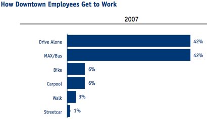
The survey — which included businesses, government entities and non-profit organizations — found that 6% of downtown employees got to work by bike (last year, the same census found that 5% of employees pedaled to work.)
Here’s the breakdown of other modes:

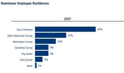
From the graphic above, we see that a whopping 42% of downtown employees drive alone (the same amount that take MAX Bus). Given that the major influencer of transportation choice is the distance from where you live to where you work, I found it interesting that only 50% of downtown employees live within the City of Portland (with 9% living in the City Center).
Here’s the breakdown of where downtown employees live:

This underscores the importance of creating more affordable, bike-friendly housing options in the inner city.


Thanks for reading.
BikePortland has served this community with independent community journalism since 2005. We rely on subscriptions from readers like you to survive. Your financial support is vital in keeping this valuable resource alive and well.
Please subscribe today to strengthen and expand our work.
Given that that was the 2007 data (where gas only hit $3/gallon in November), I\’d be REALLY curious to know what it is now with $4+ /gallon gasoline.
So, that 41% listed as living in the \”City of Portland\” is really for \”City of Portland outside of the City Center\”? Or is \”City Center\” a subset of the \”City of Portland,\” as it is conceptually?
I\’m a little offended. I live in City Center and I am very much apart of Portland.
I believe that PBA\’s report is for the Central City – which here includes the central eastside. Rose Quarters/Trail Blazers are on their top 10 list of largest employers.
a.O, (2)
If you add up all the percentages, they equal 100%. It sounds like City Center is being counted separately from City of Portland.
Well after looking at the demographics…I guess the hords of Clark County workers do not have the higher paying jobs in the city center (5%)…or else they are taking the express bus into work.
Is the city center the Interstate loop? as in, would NW portland be considered Portland-in-general?
Also, When you consider that 28% of employees live in Washington, Clark, and Clackamas Counties, where geography, density and distance has varying limits on access to public transit and safe bike routes, and we still have 6% biking and 41% using transit, that\’s fairly impressive, IMO.
And it looks like most of those cars coming into the city center are from those \’better planned\’ exurban sprawl zones of Washington and Clackamas Counties. ;-0
A teminology comment. Going from 5% to 6% is a 20% increase in the number of people who go by bike. The 1% number relates to the change in the number of bike commuters among ALL the people who work downtown.
\”Going from 5% to 6% is a 20% increase in the number of people who go by bike. \”
thanks for pointing that out pdxmark.
Washington County starts at about west 65th street, so if you work on the west side of the river (downtown proper) you can be just as close to your job as someone that lives on east 30th, but not technically in city limits. Of course, it is a lot harder to ride your bike from there…
Regarding #11,
West 65th st to city center is well over 3 times the distance as 30th st. on the east side. Blocks on the west side are very suburban and blocks on the east are more livable.
the distance from 30th and Burnside to 5th and Burnside is the same as 5th & Burnside and dead center of the forest park boundary.
\”West 65th st to city center is well over 3 times the distance as 30th st. on the east side. Blocks on the west side are very suburban and blocks on the east are more livable.\”
While I agree that the land has been divided differently, there are approximately 18 numbered street \”opportunities\” per mile in the metro area. In some places there are more than 18 streets per mile so there is a \”29th street\”, and then a \”29th place\”, and then a \”30th street\”, and in other places there are less than 18 streets per mile leading to a \”182nd street\” and then \”185th street\” with nothing in between. But in any case, W 185th in Beaverton and E 185th in Gresham are both 10 miles from the river.
Matthew, if you use Google Earth to measure, one would find that, in Portland, there are 20 blocks to the mile. You were pretty close, but 20 works a bit better so far as multiples and divisors go.
In some places in Vancouver, however, it is 18 blocks to the mile before standardizing at 20 blocks. Maybe it\’s the same out west, but I don\’t live there, so I wouldn\’t know.
Generally Vancouver has the 20 blocks per mile address structure too.
20 makes a lot more sense, thank you. I was just kind of eyeballing it. (And then I was trying to figure out where the 18 came from because it seemed like an odd number.)