The Transportation Options division of PDOT has just printed up 30,000 new city bike maps (not to be confused with Metro’s “Bike There” map). I got a look at them first-hand today thanks to long-time Options staffer and mapping guru Jeff Smith.
Jeff pointed out that for the first time ever, they’ve devoted a full section a small section on the back of the map to the city of Beaverton (about 8 miles west of Portland). Here’s a little sneak peak…
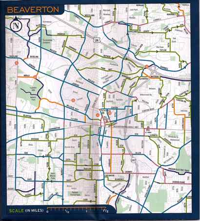
The other exciting thing about the map is that is substantially larger than before. A full fold bigger than the last one, it now lists more parks and background streets.
Jeff said the City received a lot of feedback about the lack of labels for background streets — side streets that aren’t officially bikeways and were not labeled on previous versions of the map.
For your copy of the new map, pick one up at a local bike event or bike shop, or visit the bike map page on PDOT’s website for downloads and information on how to request one.


Thanks for reading.
BikePortland has served this community with independent community journalism since 2005. We rely on subscriptions from readers like you to survive. Your financial support is vital in keeping this valuable resource alive and well.
Please subscribe today to strengthen and expand our work.
I\’ll be honest, I\’ve never bike-braved Beaverton.
Not that I don\’t appreciate the resource (I occasionally do \’bike-brave\’ Beaverton), but why exactly is the city of Portland spending money publishing a bike map of the city of Beaverton?? My hope is that the answer to that question is \’they paid for it,\’ but that is not my guess.
Yes… but ARE THEY PRINTED ON BANDANAS?!!!?
Perhaps I should have referenced this URL for those that weren\’t around when we discussed this before:
http://bikeportland.org/2007/04/23/pdots-new-bike-map-bandanna/#comment-374710
As in Post #2, I too am wondering why Portland is doing this. I would think Washington county would/should take a project like this on.
I bike through beaverton every day and what I see on the map agrees with the routes I use.
Also, as I live in washington county a really don\’t need a map at this point. 5 years ago it might have been useful. But it will be handy for new cyclists and to Portlanders coming out this way just as the Portland maps are useful to me on my trips through Portland.
That being said, resources for the westside are scarce. Even on this site there isn\’t even a listing of bike shops (hint).
Folks, please realize that this Beaverton section of the map is just a small, inset square of the much larger map.
Sorry I did not make that clear in the article.
Including Beaverton routes is good, because of all those folks who live IN PORTLAND and commute out west. You know, kind of like the folks that live in Clark County and commute into Portland.
I\’d sooner they rode their bikes to the Beaverton area, rather than drove their cars.
There does exist a very nice Washington County bike map, btw.
Considering that Beaverton is next to Portland, including it makes sense. As to the costs of including it, I think those are negligible. The bike route data is maintained by Metro and could be easily obtained by PDOT staff. Given the size of the insert, there\’s no reason to bellyache over this.
Enough with the provincial Portland think! Lots of Portlanders commute to Washington County for jobs out there (Intel, various other tech firms, Nike, etc.) Plus, if more suburbanites who normally drive into the city switched to bikes, wouldn\’t that benefit us all?
I am surprised and disappointed that so many posters on this site cannot see that cars, carbon emissions, and congestion are regional problems. Pollution doesn\’t know to stop at the Portland city limits. Including the suburbs next door may encourage more people to ditch the car in favor of bikes and mixed-mode commuting.
Why should PDOT spend any money to provide resources that might help people bike in Beaverton?
Here\’s one reason: one third of Portland\’s morning traffic comes from outside of Portland!
Funny to read these posts. I always considered myself a \”Portlander\” and proud of it. I didn\’t realize that the boundaries of Portland ended at the west hills. Sad… Considering I have a Portland address and live a spit away from Beaverton. Sad that Beaverton, only achieved the list of bicycle safe communities (http://www.bicyclefriendlycommunity.org/press_beaverton.htm) along with Portland.
All kidding aside. I read this blog daily and really wish folks would not be so biased. I ride to work every day from the west side through Downtown. Many of us do on a daily basis and we never get donuts or smiles or pictures of us crossing over Sylvan hill. We put up with the same dangers as in Portland. We get written up in the Bike Portland blog when some motorist kills one of us. But for some reason we don\’t get any respect.
Beaverton is a good place to ride. Granted, riding down Canyon road is not fun, but so isn\’t riding on Powell. If you live or work here, you know where to ride, just like east side folks do. This map helps those who may not be familiar with riding in the area, not just Portland proper.
We all enjoy a great community, Washington, Multnomah or Clackamas. We\’re all require the same level of respect. Metro is a regional government body that covers all of the metro area not just the east side.
~n
Way to go Brad!
Lots of folks live in Beavertron and work in Portland. I guess Portlanders would rather save 5 cents and have thousands of commuters drive past their homes!
Jesse (#2) and John (#5) – because the target area for Smart Trips this year is SW Portland. I don\’t know the details, but I\’d wager that the extra cost might be footed by Metro. Metro gave PDOT a grant last year for the Smart Trips SE program to print maps of Milwaukie. Jeff Smith, the map god at PDOT put the map together.
To be honest, the only extra cost involved is a few dozen hours of Jeff Smith\’s salary and some incidental expenses – most of the fact-checking is done by volunteers, the printing costs aren\’t affected at all, and since they expanded the map, there would have been extra space on the back side to put whatever they wanted to – why not have Beaverton? Some of us actually ride there, and especially those of us in SE.
Now if Metro would do the same with the Bike There! map to show the area around Canby, Aurora, Sherwood and Newberg, I\’d be all set.
I never thought I would read the words bigger, better, and Beaverton in the same sentence…
nice comments, Nick. You are correct. You are a Portlander.
Matt (#13), you\’ve got it pretty much right — we wanted to expand the City map scale & size to provide more detail (I\’ve had some serious map envy going on over the recently created Vancouver map…) that would allow the addition of background streets, hill arrows, bike shops, and just an all-around better, more readable look.
As a result of expanding the size we had some extra space on the reverse side for inset maps, & since the Beaverton area is underserved bike-map-wise (there\’s no free map of this area, only the Metro map at $6 and the Washington Co. map at $3)AND PDOT\’s SmartTrips effort for this year is in Southwest Portland, AND since i field tons of requests from Portland bike commuters wondering how to get around in points west of the hills, including Beaverton just seemed like a natural.
I\’d be remiss if I didn\’t thank the Beaverton bike committee folks who vetted the map information & provided hot tips, and Anne at Grapheon Design for her fine work, as always, on the map.
Jeff Smith
PDOT Transportation Options
Nick, you are showing too much common sense. I like that about you, but most people here won\’t get it.
Now if this magical bike map could include the rest of SW Portland, down into Tigard, as well as Beaverton….
The current map makes it look like the world stops for bikes at the top of the hill on Barbur.
Oh, wait! I forgot: It\’s not PORTLAND, it doesn\’t COUNT here.
😉
All kidding aside, I\’m thinking of creating my own cycling maps for Tigard and sending them to my neighborhood area blog.
From PDOT\’s website that you linked to in the article, I opened each map files they provide but I cannot find the Beaverton map you are talking about.
What is the direct link or the name of the link on that page?
Kudos for adding Beaverton! I think it would be great to cover the entire metro area- Beaverton, Gresham, Tigard, Hillsboro,…
Cycling in Portland is great (and there is always room to improve)- but we still have a lot of work to do to make the suburbs bike friendlier!
Rian, the old map version is still up on our website. I\’ll endeavor to get the new version up there early next week.
Hey Jeff… Can I bug you about a bandanna? 😉 ;0)
@Nick #10 /agree nice comments.
I\’m with you, I commute from SW Hillsdale through downtown to Northern Vancouver and I don\’t see any donuts or pictures being taken. Just because we are going the opposite direction as most shouldn\’t make us invisible. We still love to bike and contribute to the cycling community.
Sry that would be @Nick #11
Sounds like a story brewing, Rick…
I would encourage my fellow Portlanders to not let their fear of Beaverton stop them checking it out. I live in SE Portland and used to work in Beaverton, west of the Nike Campus. Every morning I\’d ride across downtown PDX, hop onto the MAX at the Salmon St. station (across from the MAC), ride MAX thru the tunnel, exit at Sunset Transit Center, cross over Hwy. 26 on the pedestrian/cyclist overpass, and then ride Park Way all the way downhill to Walker Rd., which has bike lanes. It was a piece of cake, and very safe!
Riding my bike & MAX to my job in Beaverton was literally 15 minutes faster than taking transit the whole way.
It\’s OK to have some fear of riding in Beaverton. Beaverton is not as bike-friendly as Portland. But remember the definition of courage: \”Courage is feeling the fear and doing it anyway.\”
I am happy about the map! I ride ten miles out to the Beav every day 4 work and it is kinda scary but this will prob help me find a less trecherous journey. Maybe this will inspire some Beav kids to ride into Portland instead of always bussin or maxing it with their bikes. Boo ya
As a proud citizen of Southeast Portland — who works in Beaverton — I\’m thrilled that we included a Beaverton inset in this map. In fact, my biggest frustration (other than the lack of minor-street labeling) with earlier versions of this map has been that it stops at the city limits.
Of course we also have the Bike There! map for those who really want to see the whole metropolitan area, but I think it\’s good to include Beaverton on this map because the density of POTENTIAL commuters to and from Beaverton is perhaps greater than with the other suburban areas, and because finding a reasonable route between the two cities is particularly daunting. You have the west hills in the way, and the very few safe routes through are NOT obvious or well signed. It is only with a good map that people will even know how to do it.