It has been wonderful to see BikePortland commenters refer to the Office of Community & Civic Life’s new neighborhood profiles. We reported on them a couple of weeks ago in our Portland Engagement Project post, and I’ve noticed some of you referring to stats from the profiles in your comments. That’s great!
Shortly after we wrote that article, the Office of Community and Civic Life issued a press release with much of the same information.
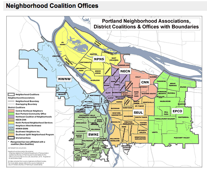
With one exception. The press release offered a preview of their new Neighborhood Association and District map (at top).
A comparison with the old map shows a small boundary change—the northern-most SW neighborhood association, SWHRL, joined the Northwest coalition. And the new map has substituted icons for coalition names.
Editor: The last several paragraphs of this story have been edited out per the comment below from the Office of Community and Civic Life. (10:23 AM 2/14/2023)


Thanks for reading.
BikePortland has served this community with independent community journalism since 2005. We rely on subscriptions from readers like you to survive. Your financial support is vital in keeping this valuable resource alive and well.
Please subscribe today to strengthen and expand our work.
We appreciate the dialogue. Perhaps we should feature the news release hyperlink, as many commenters have already connected this work with the Charter Commission’s work and the work that is about to happen within the Independent District Offices as stated in the news release: 95 Neighborhood Profiles Showcase Economic And Livability Issues | Portland.gov
Another news release will be out soon about the Portland Engagement Project, and how the public can participate.
We look forward to working with the Bike Portland team about how we intend to earn Portland’s feedback to more formally address the comments posted by several commenters.
Earn Portland’s feedback?
Sorry but I don’t understand.
When I was new to Portland, I dove into my NA with enthusiasm. But like so much else in this city, it all seemed so futile and broken that I couldn’t wrap my head around it.
Don’t get me wrong: there are good things happening in dribs and drabs, and I’m grateful for the people who are able to stay engaged amid the chaos, but it’s all too much for me.
I can’t imagine what the office of civic whatever is up to nowadays. Seems like Chloe and JoAnn broke it, but then again the rest of city gov’t seems broken. Bring on the new city gov’t in 2025, with professionals in charge!
Like Fred, I too became involved with our Neighborhood Association, and was on the Southeast Uplift (SEUL) Land Use and Transportation Committee for several years. I was disappointed that PBOT rarely made an appearance at SEUL (potential land use code changes got a lot more outreach from BPS). There wasn’t a consistent system or method to inform, or solicit input from, the neighborhood associations or citizens about upcoming transportation projects. The one exception was the Division Street improvement project, and most of our information came from a SEUL representative on the advisory committee. PBOT almost never reached out to SEUL or our Neighborhood Transportation Committee before planning or implementing a project, unless we pushed for the safety project. Letters from our Neighborhood Association to PBOT often went un-answered. Not what I’d call good community relations. I know several PBOT staffers who are great and fight for better bike/ped facilities every day, but for some reason upper management doesn’t feel the need to communicate with the NA’s.
Having said that, I’m somewhat optimistic the new city structure will provide an opportunity to fix this. Having one council-person representing our District could elicit better communication. In an ideal world each District would have a staff person tracking infrastructure projects in their District and providing outreach to their constituents, be that neighborhood associations or citizens at-large.
I also suspect the neighborhood coalitions might get shifted around to match the pending Council Districts. At least I hope so for the sake of simplicity. Time will tell.
Hi Lisa. We wish that you called us about this follow-up story. We’re working on a complimentary map for the District Offices that will actually have more detail and indeed recognize/name the office. These maps will be shared later this spring. Not all neighborhoods have a neighborhood association, so we’re still working on a visual to reflect this, especially because there are inactive neighborhood associations, but the neighborhoods itself exists. Let’s work together on the next one, please?
Hi Civic Life, thank you for commenting. I have removed my speculation from the story and apologize for possibly starting a rumor. You are right, I should have given you a phone call (and look forward to doing so in the future).
Here’s how things appeared from my end: Civic Life contacted BikePortland a week after our story ran to alert us that the map we ran in our first story was “incorrect” and “outdated” in that it implied that SWNI was a city-recognized district office (which it no longer is). The email directed us to your PR “preview of Portland’s neighborhood and districts” map. BP doesn’t update things retroactively, so I thought I’d do a brief followup to get the new map out there.
Don’t be worried about offending Civic Life. Their main activities recently have been telling Portlanders what Halloween costumes to wear and promoting marijuana use.
There’s an error on the map: The city of Maywood Park is not part of either the City of Portland nor in the East Portland district. It should be colored the same as Gresham.
Also, the overlap between Hazelwood and Mill Park was resolved unilaterally by Hazelwood in 2013 or so, to Mill Park’s favor, in Hazelwood’s amended bylaws.
Getting a response from someone at civic life is pretty much impossible but here they are nitpicking an article about the borders of neighborhood associations. We should get rid of them altogether.
Reminds me of the old TriMet symbols. Seems like the wrong time to be rolling out a rebranding or the neighborhood offices, just before new voting quadrants are created and as the OCCL gets reorganized into OERH. But efficiency and coordination are less of a priority than cute graphics I guess.
I hope that Civic Life is able to revive the neighborhood coalitions. Several are completely dead (like SWNI), and some, like SEUL, spend their time on infighting and petty power struggles, forgetting about the democratic ethos that once undergirded the system.
Southwest Neighborhoods, Inc. is not completely dead. SWNI has historically had separate land use and transportation (and other) committees that have benefited by the collaboration among our community volunteers. SWNI leaders recently co-signed the letter Lisa described on February 9 advocating for safer biking and walking infrastructure in SW Portland.
Regarding the Office of Community and Civic Life’s new maps, I have a lot of issues with Civic Life Neighborhood Profiles Maps datasets. Is this considered a “baseline” that will be monitored over time? Toward what outcome? Civic Life did not reply to our neighborhood’s comment that Crestwood and Ashcreek neighborhood boundaries changed in 2016, so if 2010 is a baseline then the 2010 and 2020 data is not comparable without a footnote to that effect. PSU published the datasets at https://www.pdx.edu/population-research/neighborhood-profiles. What is the data from “Portlandness” that is cited in these neighborhood profiles? What is the data behind the many variables in the social vulnerability index? What do the “top ten” and “bottom ten” rankings mean? What about other data of importance in our neighborhoods, such as the street surfaces maps that PBOT used to publish, or safety data such as PBOT’s Vision Zero maps?
As Wilbur noted, Portland City Council’s recently adopted Transition Plan, Exhibit B, directs the Office of Community and Civic Life and the Office of Equity and Human Rights to “evaluate the city’s neighborhood associations through an equitable lens, with metrics, and produce a report identifying high impact and strategic opportunities for collaboration between Bureaus, the City, and Portland neighborhoods.” I wish I knew more about this effort than this single sentence in the Action Plan. It’s as vague as the Portland Engagement Project.
Side note: PBOT’s role in the Transition Plan is discussed in Exhibit C, the public works service area.
SWNI might not be dead, but it is pining for the fjords.
On a less comedic note, I agree the neighborhood profiles are unclear in both intent and utility, and the PEP seems rudderless. I hope residents will be able to help steer it in a productive direction, and I’m relieved we’re having this conversation while there is still a political leader in charge of Civic Life, rather than an appointed bureaucrat.
Are the boots representing north Portland a reflection of the state of the streets and sidewalks- unswept, lots of debris, and in disrepair? I have lived in North Portland since 2008- the boots do not resonate with me. I suggest Western Pond Turtle, or the St John’s Bridge instead.
I would have thought an SUV would be more appropriate symbol for East Portland than a food truck.
Or how bout someone slowly shaking their head after another put down from our betters on the other side of the 205?
You mean like from Lents?
Nobody who works at Civic Life has ever dared to come up to peninsula so they just defaulted to some random image.
Thank you for the informative article. I would like to offer clarification on one point. While District Coalitions are primarily comprised of representatives from neighborhood associations, it is important to note that they are not limited to this exclusively. In accordance with city code, a simple majority, or 51%, of the board seats must be occupied by representatives of neighborhood associations. However, non-profit organizations have discretion to formalize a different composition, as long as the majority requirement is fulfilled. This composition may include representatives from community-based organizations, business associations, at-large members, etc., depending on the non-profit board’s willingness to welcome voices to the table.
Thank you.
My understanding is that OCCL is tweaking the information that it has on all of the “Neighborhoods”, so that the demographic info can be used in the process of drawing the 4 new Council districts. I thought the article was about that map. This included map shows that nothing changed, except that SWRL has switched coalitions. The Council Districts will be the news we’re looking for.
Wow, talk about a map that is not friendly to the roughly 5% of all people with red-green colorblindness. The SE and E areas are almost indistinguishable. Someone needs to remind Office of Civic Life that they are supposed to make their maps accessible.
I love the new Williamette river naming.