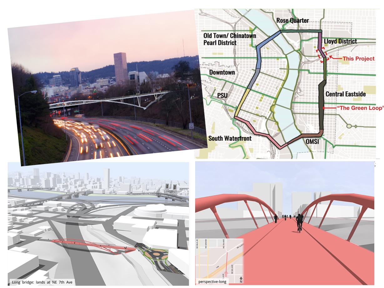
(Map by KPFF, renderings by Fat Pencil Studio)
For years people have dreamed of a low-stress and convenient bikeway between inner southeast Portland and the Lloyd District. Now it’s becoming a reality.
The Portland Bureau of Transportation is moving forward with plans to build a new carfree bridge over Interstate 84 that would connect 7th Avenue between NE Lloyd Boulevard on the north end and NE Flanders on the south end.

But wait, there’s more. In addition to the new bridge, PBOT is considering a major road diet and “protected intersection” treatment at the Lloyd/7th intersection (see below). The project would also include an engineering and planning analysis for the westernmost portion of the long-awaited shared-use path project known as the Sullivan’s Gulch Trail.
The details of this project are in a request for proposals (PDF) that came out last month and in a report prepared for PBOT by a consulting firm back in April (PDF) that analyzed different bridge types and alignment options.
The new bridge and related improvements would unlock vast placemaking and cycling potential along the NE 7th Avenue corridor (designated as a “major city bikeway” in the recently adopted Central City 2035 Plan). As we reported last year, this new bridge is essential for the successful development of the Lloyd District. Former Bicycle Transportation Alliance staffer Carl Larson told us at the time that, “It’d be a game-changer” and said, “I describe it as MLK for people walking and biking.” (The project is one of 16 prioritized regionwide in the BTA’s “Blueprint”.)
Portland had a chance to create a high-quality, north-south bikeway in this area when streetcar came to MLK and Grand in 2012. Unfortunately the eastside streetcar was not only built without adjacent cycling facilities; but in many ways it made cycling worse by taking up the entire right-hand lane and by adding new crash hazards due to exposed rails. This project on 7th could be the north-south biking access people have clamored for for over a decade.
The new bridge and other improvements are also seen as key pieces of the city’s “Green Loop” — a six-mile park and path that will someday ring the central city.
Advertisement

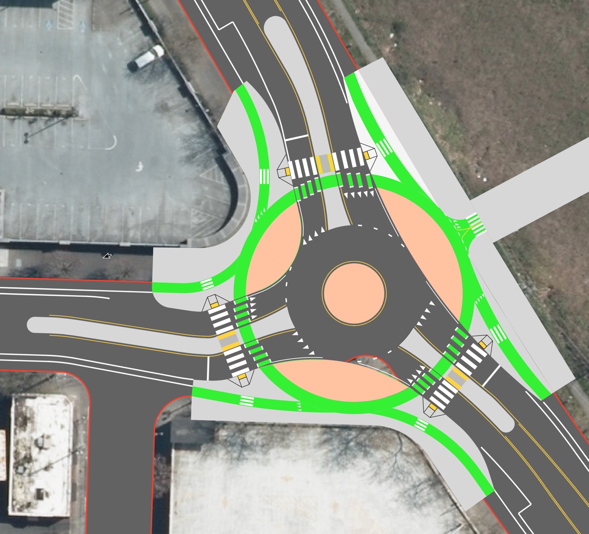
Here are the two treatments — a protected intersection and a roundabout — PBOT is considering for the north landing of the new bridge at NE Lloyd and 7th:

While still early in the process, PBOT currently recommends a “deck-tied steel arch with drop-in span” bridge design that would be 24-foot wide and span 470-feet across Interstate 84. One of the proposed cross-sections shows the 24-feet split between two six-foot sidewalks and two six-foot bike lanes. The alignment of the bridge isn’t under debate for the north side; but there’s still some question what will happen on the south side. PBOT prefers a longer and more direct bridge that would connect 7th Avenue on both sides. Another option would be a slightly shorter bridge that would leave from NE 8th on the south side.

In an alternatives analysis report created for the city, engineering firm KPFF estimated the cost of this option to be between $9 and $13 million — almost all of which would be paid for by System Development Charges, which are fees paid by developers to offset increases in road usage. In April of this year, City Council enthusiastically approved an ordinance that made this project eligible for up to $11 million in SDCs. PBOT Communications Director John Brady told us today that PBOT already has about 85 percent of the funding and are in conversations for the remaining amount.
The company that will design, engineer, and manage the project will be selected in January 2017. A design and public outreach process will then begin and is expected about to last about two years with construction starting in 2019. Stay tuned for open houses and other opportunities to provide feedback.
Learn more at the official project website.
— Jonathan Maus, (503) 706-8804 – jonathan@bikeportland.org
BikePortland is supported by the community (that means you!). Please become a subscriber or make a donation today.


Thanks for reading.
BikePortland has served this community with independent community journalism since 2005. We rely on subscriptions from readers like you to survive. Your financial support is vital in keeping this valuable resource alive and well.
Please subscribe today to strengthen and expand our work.
This is fantastic news. After scanning the report, my big concern is that they will choose Alignment #2 because Alignment #1 “may potentially have a negative impact to local truck traffic” despite it being significantly more expensive than the baseline AND having a worse grade (4% vs. 3.4%).
Questions:
Are they signalizing the intersection at 7th & Lloyd?
The design looks very nice, like something that Nick Falbo would do, but why are they not allowing bikes the option to act as street vehicles, rather than as pedestrians only, by allowing a ramp directly off the bridge, rather than funneling riders to one pedestrian crossing or the other?
Are they putting a tall barrier between the bridge end and Lloyd, or will bikes be able to jump the curb directly into traffic, to cross over to 7th or head downhill on Lloyd?
Can bicyclists coming off the bridge see a signal?
Agree. We don’t need to wind bikes around a maze of green paint. Just give the intersection a bike signal off the bridge and continue the existing bike lanes like normal. Protected intersections like this are confusing and out of place as long as the bike lanes leading to the intersection are run of the mill unprotected lanes… all or nothing please.
What amazes me is that given 105 blog posts so far on this project, how few folks have latched onto the precedent of City Council approving to use SDC funds for 85% of the costs. Basically, if you want a dedicated bike/ped bridge anywhere, and who doesn’t, then 85% of the costs can be paid with SDC funds, which PBOT has a huge surplus of, unlike the rest of it’s budget. While I personally would prefer a bike bridge over I-84 at 132nd rather than 7th, why isn’t anyone advocating for such a bridge over the Willamette?
1. We just got a car-free bridge over the Willamette. 2. Because it would at least an order of magnitude more expensive than a 400 ft. steel deck over a gulch.
But yes, the SDC precedent is a great point, thank you!
Tillikum is a flop – the railway connections, and confusing lights at each end, coupled with the unnecessary hill climb, I will continue to take the Hawthorne like most people
Gary observes regarding another bike-only crossing of the Willamette:
“2. Because it would at least an order of magnitude more expensive than a 400 ft. steel deck over a gulch.”
Perhaps not, if the span did not have to be created from scratch: imagine a cycle path hung below or cantilevered off the sides of an existing bridge as some have suggested. I wish I knew something about civil engineering; it might be an interesting design challenge.
I remember talking with an engineer about 18 years ago when I first moved to Portland who talked about doing just that, hanging it from the Marquam (I-5) bridge. There was no funding at the time, of course, and ODOT is a terrible partner, but it seemed like a good idea at the time.
This would create such an integral, important link in our network. And I’d get to use it most days on my way to the gym- huzzah!
I like how it resembles the Fremont bridge, snubbed for no access for walking and biking 24/7.
Will PBoT never learn? By making the bridge with twelve feet of sidewalks and two six-foot bike lanes, the bikes get wedged into an unnecessarily narrow space. That is a design that only succeeds if cycling numbers stay failingly low. In their proposed configuration, the outer foot of each bike lane is effectively unusable because of the curb. The center area also has a loss of a foot of width because no one wants to ride inches from an oncoming bike. That works out to just four feet of useful width to ride in each direction. That’s fine as long as there continue to be very few riders, but not so much if PDX ever gets people out of their cars.
Alternatively, PBoT should either go with only one six-foot sidewalk or just put in a 28-foot bridge to begin with.
I guess 12 is less than 6+6? There is so much hyperbole in your comment, I’m not sure where to begin. I’ll just link to these images from Copenhagen instead:
http://getbritaincycling.net/wp-content/uploads/2014/10/Copenhagen-cycle-route.jpg
http://therecord.blogs.com/.a/6a00d8341c465d53ef0133f21e8ad8970b-pi
http://farm5.static.flickr.com/4047/4303535548_6e55dc0d92.jpg
One-way cycle lanes in Copenhagen are at minimum 2.5 meters (8 feet) wide. The proposed cycle lanes for the new bridge are 6 feet wide.
Yeah… but the Cycle Snake is 4m (13 feet) wide. That seems like a good benchmark.
http://www.cycling-embassy.dk/2014/09/26/the-cycle-snake/
It seems to me that the opposite-direction bike space would allow for some passing. But I think that you’re right that if volumes became extremely high (for a pretty clear example, imagine Hawthorne Bridge rush hour levels going both directions at the same time) then it would be inadvisable/rude/dangerous to pass at some hours of the day, which would be unfortunate for a new facility.
I’d love to see a bike volume forecast for this facility compared to the Cycle Snake’s volumes (and some color on whether the Cycle Snake feels too narrow with that volume). I think that would give a good comparison.
Alex and Adam —
I rode the Cycle Snake bridge, and typical cycletracks in Copenhagen.
Typical cycletracks, at 2.8 meters, are very comfortable and safe for people on bikes to pass each other. I rarely felt constrained by slow traffic ahead, or crowded by traffic behind who wanted to pass me.
Photo, 2.8 meter Cycletrack (9′ 2″)
https://www.flickr.com/photos/11599639@N03/30633712564/
Photo, 3.5 meter Cycletrack, (11′ 6″)
https://www.flickr.com/photos/11599639@N03/30633671584/
Video, 2.8 and 3.5 meter Cycletracks
https://www.flickr.com/photos/11599639@N03/30634176214/
at 120 seconds, at about 3.5 meters wide, it’s plenty wide for 3 users side by side.
at 153 seconds, at about 2.8 meters wide, it’s tights, but manageable for 3 people side by side.
The Cycle Snake bridge, at 4.2 meters, is too narrow to accommodate typical weekday traffic — even if there is no oncoming traffic it is very cramped to overtake someone else.
Photo, 4.2 meter 2-way bridge (13′ 9″ total, 0r 6′ 11″ each way)
https://www.flickr.com/photos/11599639@N03/30666651663/
Video, 4.2 meter 2-way bridge https://www.flickr.com/photos/11599639@N03/31437913466/
at 40 seconds, the rider ahead of me overtakes the rider in front of him, with tight quarters.
at 145 seconds a family bike is pulled all the way to the right but other riders still can’t overtake.
The Cycle Snake bridge is not up to the wide, comfortable, “travel at your own speed” feel that is nearly ubiquitous elsewhere in the Copenhagen bicycle route network.
Based on this, I agree that a bridge that is going to be “The MLK for bicycles” and have a 4% grade probably ought to be wider than 12′ if it’s going to be built for Portland’s inner city bicycle mode share exceeding 25% of all trips.
Ted Buehler
Thanks for the info Ted. Looking at your video of the 13′ two-way bike bridge, I now agree that 16′ is the right width for a high-volume two-way bike facility.
Agreed on width – if this is going to be part of the green loop – build for the future expectations, demands and what they hope the foot/bike traffic will be.
That can be solved with a low 5 cm curb and beveling it at a 30 degree angle, you’ll bounce back not fall.
Just go slower.
9-foot sidewalks are the standard, why don’t they do that and give cyclists the extra 6 feet?
Easily mountable shallow curbs, please. Consider the Hawthorne for comparison. Sidewalk width is, I believe 10′ (in each direction). I’m sure there are bike/ped conflicts, but generally pedestrians are smart enough to stick close to the railing and let faster traffic go around on the left. As drawn, and some of you have heard me rail about this already, this is building for the previous century.
That intersection design looks fantastic, and offers cyclists full protection from motor traffic. Though I would push for a 20-foot cycleway, rather than 12-foot. 6 feet is not enough room for a cyclist to pass another. Glad this bridge is being build though, and being funded from SDC’s, which I have argued should be going towards building cycling infrastructure.
Have to disagree there. Seems markedly over-engineered and separated. Probably not very intuitive to use. I’ll likely end up in the car lane.
I ride a slow, upright Dutch bike, and greatly appreciate the separated lanes. You see “over-enginnering” and I see a separated space for me to ride my bike without drivers breathing down my neck. Most people will not want to take the lane.
I’m fine with riding close to others.
You’ve also said that Tilikum/Moody is great. There’s just something about physical separation that blinds your critical eye.
Yeah, must be all those impatient drivers that I’m not having to worry about.
Thats one of the worst connections in Portland, and I’m dismayed that something so non intuitive has become the new engineering standard.
We are not a problem to be pushed off to the side, with our own separate lights that let us go as an afterthought when all the “real” traffic has passed.
Another way to look at it is that we are getting more respect because we’re getting our own signal phase that is free from conflicts from motor traffic.
There are only so many ways we can ride the same streets yet have completely different experiences.
6′ is plenty of space as long as you keep your slow boat off to the right. 6′ is enough room for two riders abreast who are both using uncut ENVE DH bars. Being stuck inside all that green paint is what bugs me. I’d rather be able to use an auto lane if I’m traveling as fast as auto traffic.
6 feet is tight, but 12 ft shared by traffic going in two directions is fine. Unless you have solid traffic flowing both ways, there will be ample space to pass. People do this on the Springwater all day, every day.
This is a brand new bridge. There is no reason that it needs to be tight right off the get-go. The bridge should be engineered to accommodate future bike traffic. Given the increasing densities of the Lloyd, I imagine this bridge will get quite a lot of usage in a few years time.
…and I assume the design should contemplate and consider use by future bicycle / HPV freight vehicles…so would the current 12 foot wide bi-directional roadway space accommodate SoupCycles / B-LinePDX (UPS too) freight last mile vehicles? I doubt it.
Absolutely. Adding 5 feet of width adds a few percent to the price at this point. Adding capacity later? Much more difficult and costly.
This crossing will be much shorter than the Willamette River bridges (or of course the Springwater). There should be a lot less need for cyclists to overtake each other.
How do you figure?
I would suspect that increasing the bridge from 12 feet to 17-18 feet would add at least 30% to the cost of the bridge, if not more.
In my opinion, the intersection design is terrible. There’s only 1 way to get onto the bridge without back-tracking.
There’s also a gigantic curb cut right in the middle of the “protected” bike lane, and the on-street parking causes the bike lane to swerve all over the place like a drunk, and leaves a huge crossing that’s completely unprotected from stressed government employees driving to their jobs.
Not sure what you’re referring to. There’s no curb cut right in the middle of the cycleway, nor is there any parking along the curb of the cycleway.
Here’s the gigantic curb cut (for an existing garage): https://www.google.com/maps/@45.5278651,-122.6585954,3a,48.9y,223.54h,79.66t/data=!3m7!1e1!3m5!1sNnvD9F9joOMtGqfIW6YTLg!2e0!6s%2F%2Fgeo3.ggpht.com%2Fcbk%3Fpanoid%3DNnvD9F9joOMtGqfIW6YTLg%26output%3Dthumbnail%26cb_client%3Dmaps_sv.tactile.gps%26thumb%3D2%26w%3D203%26h%3D100%26yaw%3D14.080871%26pitch%3D0%26thumbfov%3D100!7i13312!8i6656
Just to the North, here’s the (existing) parking:
https://www.google.com/maps/@45.5278651,-122.6585954,3a,51.7y,340.43h,84.8t/data=!3m7!1e1!3m5!1sNnvD9F9joOMtGqfIW6YTLg!2e0!6s%2F%2Fgeo3.ggpht.com%2Fcbk%3Fpanoid%3DNnvD9F9joOMtGqfIW6YTLg%26output%3Dthumbnail%26cb_client%3Dmaps_sv.tactile.gps%26thumb%3D2%26w%3D203%26h%3D100%26yaw%3D14.080871%26pitch%3D0%26thumbfov%3D100!7i13312!8i6656
You can see the render of the cycle-way still has curbside parking, there’s no mention of if the intersection will be signalized (and, if so, if there will be separate cycle phases), and those driveways are going to cause huge problems.
I used to ride in this location every single day. It needs to be much better than this, if it’s going to be safe and easy to use.
The more I look at this, the more I prefer the roundabout design over the protected intersection design.
This is huge! I think this kind of thing should be mandatory when a highway bisects a community.
Placement of the span seems like it should be based on where they think cyclists would be coming from and going to. The crossing at 12th is fine, but MLK/Grand are cycling hostile so an option closer in seems appropriate.
As others have observed, passing on bikes will not be safe and I would be worried about people stuck behind slow heavy bikes making poor choices.
I was unaware of the Green Loop and must admit that it left me scratching my head as I can’t think of any reason why anyone would want to bike, walk, or run most of that route. The brochure and promotional material make it look like a boring cycling nightmare with the best riding along 7th Ave east.
Perhaps old town will replace parking garages and surface parking lots with nice stuff.
Agree about 12th. Seems money could be better spent giving Lloyd a road diet to improve bike lane size west of 12th and improving Lloyd / 13th / 16th intersection. Lloyd doesn’t need to be a 4 lane cut through for cars looking to avoid Grand.
I am hopeful they will make 6th the route of the Green Loop South of Sullivan’s Gulch. I also hope they make it a greenway with diverters. The option of an 8-foot, 2-way cycletrack on 7th ave sounds insanely uncomfortable and dangerous through the Central Eastside. On the west sideI like the idea of removing some parking and making the park blocks into green loop.
I think the idea of inner circulation loop that is easy to find and easy to understand as part of a mental map would be really nice for piecing together routes through town. When it was first pitched I thought it was just a gimmicky, touristy idea for people to take Biketown rideas along. Over time, I have changed my mind and now I I am excited about it, if the implementation can be done well.
” I can’t think of any reason why anyone would want to bike, walk, or run most of that route.”
Because there are a huge number of jobs, several hospitals, a major university, a number of cultural institutions, and big shopping and tourist destinations along that route, perhaps?
There’s nothing scenic and the route is slow. Better alternatives for people seeking either of those things are nearby.
Access to cultural institutions seems to be a major selling point. I didn’t realize that riding the park blocks was so dangerous and intimidating.
In the core, traffic is already slow and there are bike lanes all over the place. That’s not what most people have to deal with. They’re in areas where traffic speeds are much higher, bike lanes are much less available, and public transit times can be more than an hour each way not counting the long waits for the buses.
I’m with Tyler on this. People talk about how bad car culture is, how the infrastructure is an impediment to riding, etc. If you want to change that, give them an option that makes sense.
I guess you’re seeing something different than me. Yes, it’s technically a loop, but I don’t envision riding the whole loop around. I see it as bolstering the existing bike infra along that important corridor so I can connect easily between points. And filling in some gaps, like this bridge.
I’m not looking at it as “a loop” but a series of projects that are all needed, and the “loop” concept just helps form a coherent strategy. Broadway Bridge viaduct, a west-downtown N-S bikeway, crossing the Sullivan’s Gulch, improvements through Lloyd…these are are great projects in their own right. (Point taken on shifting priorities elsewhere, though.)
I would love a viable NS downtown bikeway as I take that particular route almost every day (including this morning) But what they’re suggesting is way too slow unless they plan on getting rid of a bunch of lights which I don’t see happening. Even going uphill, it’s too easy to outrun the lights. Going downhill is such a miserable and slow experience that you’re better of dropping to Naito.
But like others have suggested, I think there’s too much emphasis on the core, not enough on the other areas.
No mention of the roundabout in the header photo? That would be even more exciting!
Just added a mention and image of the roundabout concept that’s under consideration…
Roundabout design is a LOT better. Instead of crossing 3 lanes, peds only have to cross one to get to the ped island, making it a lot more likely cars will yield. Making the 90 degree turns a circle will make bikes flow a lot easier as well.
On that note
… there is a stark difference between a place where the culture simply accepts cars in the crosswalk as the norm (eg DC), and a place where some manner of enforcement has limited this behavior (eg NY). It can be done. But design certainly helps.
My only comment from this otherwise fantastic roundabout proposal is that the eastbound traffic flows too easily into the roundabout. The southbound and westbound traffic is forced to counter-steer left before continuing right into the roundabout. This is significant from a safety perspective as it discourages high speed merges by requiring drivers to slow down before directing their vehicles in the opposite direction. In the case of eastbound traffic, this could be significant since the ped/cycle bridge exits potentially in front of said motorized traffic. Concerns aside, I’m excited for the roundabout proposal!
No need to worry about something that’s guaranteed to happen as this is the logical thing for them to do.
I’m no traffic expert, but one thing I don’t understand is why people feel safer with configurations like this. Cars entering the circle will logically look for other cars in the circle as they cross two conflict points (crosswalk and crossbike). As they leave the circle — possibly at the same time another vehicle enters — they cross two other conflict points. In other words, the likelihood of drivers not noticing peds and cyclists while looking for vehicle threats seems high.
Much easier and safer to be in the flow in a position to be seen IMO.
Even if it is, they’re bound to stack up. In any case, my concern would be that cars and bikes are likely to move very similar speeds in a space like this and drivers may be watching while failing to notice cyclists and peds.
While watching the left and moving even at modest speeds (say 15mph), they could easily miss cyclists/peds who’d hit the crossings right after they left the roundabout. This would be especially tricky if other vehicles were entering while they were exiting.
I see what they’re trying to do, but this strikes me as visually very busy with high potential for conflict if people aren’t riding/driving/walking defensively.
This was in reply to Adam’s comment that there should be enough space for a car between the crossbikes/crosswalks and the roundabout itself
This is the exact design used in the Netherlands and it works well there.
I’ve never been there so I can’t comment on whether there may be factors that would make the design work any differently there than here.
What I would say is that I personally would feel safer mixed in with the regular traffic.
Another thing I would observe is that we seem to have a bunch of traffic patterns in Portland that you don’t see elsewhere. This is no big deal for locals who figure things out quickly enough, but people who aren’t used to these things can respond unpredictably.
Ideally, the space between the crosswalks and the start of the roundabout is big enough to accommodate a full car.
That roundabout would be just fine… in another state. If I am forced by law to take the green on that thing, as Oregon law mandates, I would either find another route or just get into a car. I would be perfectly comfortable just taking the lane through it, but crossing those lanes perpendicularly is eventually not going to end well.
I’ve managed 600,000 miles in the saddle by paying attention to those places that increase the risks from very, very small to just small. This design in this locale is a poor fit, imo. After we have proper driver training, traffic law enforcement, strict liability and lower speed limits, such a design would be fine. We’re no where near that place.
Agree. Now a left turn off the bridge is first a right turn and then a long loop through 4 lanes of traffic.
Perpendicular is the best way for a cycleway to cross a car lane. It offers the most visibility. It’s those super acute “mixing zones” and bike lane crossovers that Portland loves to install that terrify me…
If you define “best” as slowest then yes. It seems you prefer to interact with traffic more like a pedestrian, some prefer to interact more like a vehicle. Would just appreciate a design that allows for both. In my opinion the mindset of getting bikes away from dangerous drivers only allows for dangerous driving to continue and is another form of absolving drivers of responsibility when it comes to sharing the road with cyclists.
Now… if I’m pulling my kids trailer or cruising to the store in a cargo bike with my wife then I would probably use cycle path here, although I would still prefer a design that allowed for safer use of the road instead. (Like raising the entire roundabout to sidewalk level and making it all concrete. That way it gives the feel of vehicles entering a primarily ped / bike area rather than bikes and peds having to cross over primarily car areas).
I would observe that you seem to experience worse problems with car conflict than most cyclists.
Perpendicular offers minimum visibility. A modest 15mph corresponds to 22 feet per second. This means that if a driver takes one second per direction to look both ways, a cyclist coming from the first direction would cover 44 feet which could easily be obscured by a number of factors. Higher speeds associated with hills or stronger cyclists can boost those numbers considerably.
Being where people can expect you and doing things that help people notice you are key. Zipping in from the side (particularly the right) definitely doesn’t qualify.
BTW, given the snow forecast, I’ll probably take this rig to work tomorrow http://photos.alptown.com/images/Oregon.2016.TrikeOnIce.jpg I’m good at being visible so I mix in traffic all the time, no problemo.
b.
roundabouts work well all over the world, in a variety of training regimes.
your standard would cause no roundabouts to be built, or signals, or stop signs…..
Thanks PBOT! Make it happen.
If you have to cross 12th Ave. bridge to get in to the Lloyd, you know how much that intersection stinks. The north side of the bridge is a giant cluster-eff of not-at-all-synchronized traffic lights. 12th Ave., 16th Dr., the highway offramp, 13th Ave., 11th Ave., and Lloyd Blvd are one tangled up intersection that takes forever and is car chaos. Going the opposite way, the highway on-ramp on Irving backs up through this intersection, and it’s a long gauntlet of wondering which motorist will get fed up and gun it out of the queue while not paying attention to their surroundings.
I’m guessing PBOT will have this bridge up and running around 2027 or so.
This post gave me a fierce erection until I saw the construction start date. 2019? Call me again then.
Eloquently stated!
IOW RIP my boner
…so four years is not like 4 hours not the blue pill. 😉
🙂 More Blue Pill Projects! C’mon, Portland! Expedite!
I hate this. Not because I hate another bike/ped bridge. I hate where it is.
Tillikum, 405 overpass @ Lovejoy, Better Naito, Clinton/Ankeny diverters, etc etc etc… West and Inner East doesn’t need this.
82nd needs this. Barbur/Taylor’s Ferry/Macadam/Boone’s Ferry needs this. 122nd needs this. Glisan/Stark/Burnside/Division/Hwy 26 east of Gateway needs this.
If you really care about improving the quality of life in Portland as a whole by way of non automobile-centric transit modes, we have to stop piling more and more and more on the urban core. East Portland and deep Southwest are shamefully underdeveloped. This money would be so much better spent improving the infrastructure of some of the most underserved Portland residents.
As noted in the article, this project will be 85% funded by development fees. These are paid by developers for the purpose of offsetting the impact of growth on the transportation system. The Central City is where a huge proportion of the city’s growth, in both residents and jobs, is happening.
PBOT needs to find a way to deal with that growth, whether by spending money on infrastructure for single occupancy vehicles (as most cities would do), transit, or walking / cycling. In this case, they are choosing to spend the money on the last option, which is also almost certainly the cheapest option when measured by dollars spent per number of users served.
I think we need both – and the starving of city transportation funding by ODOT and the state legislature and City Council is the only thing that makes it feel like getting one is in direct opposition to getting the other. The fact is that even if 100% of City transportation funding went to East Portland going forward, it would still take decades to make up the gap in transportation infrastructure quality between East Portland and inner Portland. We need to grow the pie AND allocate it equitably.
I agree with both growing the amount of transportation funding and spending more of it in East Portland. But it’s not realistic to claim that the central city has no transportation needs.
I have no objection to using some of the $30 million in accumulated Transportation SDC surplus on the new bridge, but I will point out that Central City has already used more than it has collected in SDCs since the program started in 1997, by over $16 million, whereas East Portland is “owed” more than $8 million in SDC funds, and only is inner NE more or less balanced between what its projects have collected and what it has used. I dare say that balance will change if and when outer Powell is rebuilt, but I agree that a majority (over 50%) of any new city or state funding since 2015 ought to go to areas where infrastructure is worst – East Portland, SW, & Cully.
Do you have a source for that?
Not online, just paper copies of documents from PBOT from when I served on the Budget Advisory Committee for 6 years. Sorry.
If you are really interested in this, the person at PBOT to contact is Rich Eisenhower (sp?), who is in charge of the Transportation SDC program. They should be updating their project list now.
I agree that the central city has transportation needs. But I think the categorization of things as “needs” can sometimes short-circuit prioritization within those needs. I’d invite you to spend some time in East Portland (and Cully, and Brentwood-Darlington) and ask, “How well are the transportation needs of this community being met?” and then ask the same thing in the central city. I think the objective answer is that the transportation needs of East Portland are, by and large, not met nearly as well as the transportation needs of the central city, even when one takes the current and future wave of residents and jobs in the central city into account. Although both could and should stand to improve, I believe that the City should, as a moral matter, spend a good majority (60-80%) of its available funds and political will for transportation improvements on East Portland (and to a lesser extent purely because of demographics, Southwest Portland) for the next decade or two rather than the central city or the inner Eastside.
Portland’s Climate Action Plan has a goal that 25% of work commute trips be by bicycle in 2030. That’s tough enough to achieve as it is, but becomes impossible if we spend 60-80% of funds in an area of the city with 30% of the population.
Unless that 30% is in an income bracket that makes them far more likely to use cycling out of financial necessity. Nationwide, 49% of “cyclists” (as defined by the Census Bureau, so take that with a grain of salt) make < $25k/year.
So if you've got a significantly untapped source of potential riders due to substandard infrastructure, I'd imagine the $ to rider ratio must work out much better in East Portland than Lloyd Center.
http://www.governing.com/topics/transportation-infrastructure/memo-to-cities-most-cyclists-arent-urban-hipsters.html
Almost every census tract in the Central City has a lower median income than the city as a whole. The Central City also a huge number of low wage jobs (retail / service industry in particular).
No one is arguing that there aren’t some poorer residents in the central city. But those residents have a MUCH better experience walking and cycling than the majority of low income residents who live in East Portland.
What do you know the O just wrote an article about it today:
http://www.oregonlive.com/front-porch/index.ssf/2016/12/portlands_cost-burdened_renter.html#incart_2box
And yet those areas are the most likely to see cycling mode share growth, compared to much of the central city that may have reached a saturation point.
To me this whole argument is a little silly. We have large swaths of this city that lack basic sidewalks on major arterials. That should be priority #1.
I agree, SE Rider. Yes, cycling is a cheap date – but should one be going on dates at all when some of your children are at home hungry? Check out connected-sidewalk-less arterials like SE 111th north of Foster, SE Foster between SE 104th & Barbara Welch, etc. and tell me that this bridge ought to be at the top of our City’s priority list. East Portland has had significant population growth within the time period when we’ve had SDCs. If I’m not mistaken City has discretion to use the SDC dollars in the area where it feels they are best used, as long as they are for capacity enhancements. I would much rather see $9-13 million go towards outer Foster sidewalks and crossings than to this bridge.
OK, that was overdone rhetoric. Cycling in East Portland is a neglected child just as much as walking is. But what I’m saying is, inner Portland already has it really, really good compared to my neighborhood. The gas tax only allocates slightly more to East Portland than its share of population – as does the City’s transportation budget at lasrge. I would guess that, at that rate, it will take a century for East Portland to catch up to inner Portland’s sidewalks, etc. Are we OK with that? If not, why are we cheerleading for more spending in inner Portland with dollars that could be spent in East Portland?
Then we need more money, as I’ve been saying, to get to 25% mode share. Because people (including myself) are going to fight like HECK to get basic needs (such as sidewalks on streets with 4,000, 8,000, 12,000, or 20,000 (!) daily motor vehicle trips) met in a reasonable amount of time before we spend a significant portion of our public funds on things like a new bridge that’s 5 blocks away from another bridge that works OK for the same needs. I think a 2030 sidewalk plan needs to come before the 2030 bike plan – we were putting the cart before the horse by committing to the 2030 bike plan in some respects, I think.
I’ll cop to speechifying my original post, and using “need” as a bullet point works a lot better than “Road [x] would provide a much better cost/benefit ratio as well as help bring needed development, therefore easing the pressure on the housing and rental markets by kickstarting the development lifecycle in East Portland that Inner Southeast and North Portland are now reaching the end of said lifecycle.” 😛
This has more to do with PBOT advocating for SDC money than SDC money being available. If PBOT/the city carried the same level of advocacy and hunt for funding throughout the city, cycling would become considerably more viable.
advocating for SDC money?
That’s how it works. Idea/need. Feasibility. Funding. I can assure you needed projects not “eligible” for SDC dollars are moving toward implementation at a much slower pace and perhaps with more scrutiny.
I favor this crossing. However, it is difficult to hear we do no have funding or only difficult funding streams for other valuable projects while watching central city projects move from idea to implementation nearly overnight.
This project has been in the Transportation System Plan since at least 2007 (https://www.portlandoregon.gov/transportation/article/370477). Moving from adoption to construction in 12 years (at best) is not “nearly overnight”.
Touche from the idea angle. But the larger more specific design and thru to implementations are seemingly occurring much faster than projects outside of “central city”.
I know the 84 and 405 crossings are hugely valuable to our city. But I still have to call into question and hold the city accountable: does the strong focus on “central city” have to come at the expense of the rest of the city? That’s fair and important territory to poke at.
Technically, to get SDC funding, a project must be in the TSP, add new traffic capacity (which can include car, bike & ped), and the project must get onto a list of future SDC projects. The last list was compiled in 2007; a new list is in the process of being developed for 2017. The % of SDC funds versus all other funds for a particular project is based upon how much extra NEW capacity is being added to a project. Replacing existing capacity, such as rebuilding a sidewalk, a roadway or a bikeway, is basically not going to get any SDC funding. Adding a sidewalk where there wasn’t one (such as on 136th or on outer Powell) allows the use of SDC funding, usually at a rate up to 40% of the project cost. The 85% use of SDCs for this bridge is really quite unprecedented for several reasons, including the rate.
I think it’s much more accurate to say that the current eligibility process is “spotty” rather than clear-cut, especially since the 2007 list is so out of date. For example, outer Powell was not on the 2007 SDC list, but it has suddenly become eligible for $13 million in SDC funds, whereas 136th was on the 2007 list, but didn’t get funded until 2013-16, when a whole bunch of state funds suddenly came into play, thanks to Rep. Shamia Fagen. I think 136th got as much as $3 million in SDCs for the whole $12 million project, including for upcoming improvements.
Nobody bikes out in the 100s. It would go unused.
Do you think the low rate of biking out here in the Numbers has anything to do with decades of underinvestment, broken promises, neglect, and displacement? If not, why not? If so, isn’t the fair thing to do to invest in East Portland and begin to remedy the neglect?
30% of the city’s residents live east of 82nd. They might bike more if routes were as connected and marked as they are in inner Portland, and crossings were as well designed as those for 7th & Lloyd, especially if those routes connected to their jobs in the Columbia Corridor, Gresham/Troutdale, and Clackamas Town Center, rather than downtown Portland where so few East Portlanders actually work.
I assure you I would commute daily the 26 mile round trip to my job in Gresham if I thought I would survive.
Or at least take the MAX to a place that had safe (physically separated) connections.
While I appreciate your sentiment on supporting outer east side infrastructure, I notice a few things. There’s no infrastructure other than an old bike lane going under 405 at Lovejoy. And the Ankeney diverters are absolutely *AWESOME* in their tiny cost-to-value ratio.
I think the dialog surrounding practicality, efficiency and fairness is a huge topic worthy of significant deep dive study, reflection and action. Important.
Ankeny really needs a diverter between Grand and 11th – possibly two of them.
And signalized crossings at Mlk, 11th and 12th. And SE 6th need to become a greenway south of this bridge and complete bike safety improvemnts on NE 7th north of the bridge
Flanders crossing will be awesome as density grows, but a great deal of that new density (around New Seasons/Good Sam) is aligning with the lower volume ground level roads north of Lovejoy w/ little equal northsouth options to the Flanders crossing above 405. I often hop around NW via bike from the Pearl and currently today have zero issues — a far easier ride than even cycling around residential streets in St. Johns.
For me, the Flanders crossing is a bigger more immediate win for pedestrians. NW is going to have a lot of direct options/choices — will be nice for sure. Flanders greenway will be great too. Everett and Gleason are ickier everyday.
Agreed on the diverters. And I’m referring to the planned bike/ped bridge over 405 @ Lovejoy, but you make a good point that it was the only one in that list that is still in the planning phase. See my earlier post reply re:speechifying XD
Zow! This’ll make my husband really happy–that’s his daily bike commute. Very glad to hear about this!
Middle of the Road guy: “I’m fine with riding close to others”
Some others may not welcome you riding close. I personally don’t care as long as you don’t presume to draft me in the commute hours, or say on your left 3 feet from my ear instead of just passing calmly like the other 200 people.
Also, PBOT it’s never too soon to put in the protected intersections, not only the one on Lloyd Blvd and 7th but also the presumed protected intersection at Sandy and 8th if this green loop idea is to mean much.
Woo hoo!
They aren’t thinking big enough (shocking). Want to do something truly meaningful..and cheap?
Lloyd Blvd is 2 lanes each direction (wasteful). Make the South side bikes only and the left side for cars. Make 16th from Lloyd to 15th Bike only.
That is thinking big. This is about simply spending money and looking good.
If you look at the concept drawings, it appears they will be putting Lloyd on a diet. I see 1 lane in each direction with a turn median and parking protected bike lanes westbound.
It’d also be the cheapest possible way to get that first leg of the Gulch Trail done–just reclaim some of the over-capacity Lloyd Blvd, then connect to the new trail at 16th.
Converting the south 20′ of Lloyd east of Grand would work OK for the Sullivan’s Gulch trail, but there is space south of the existing curb to build it along the top of the bank with better views and better separation. I would rater see see the south side Lloyd turned into stormwater planters and large trees to buffer the sidewalk and bike path. To make the Sullivan’s Gulch Trail successful, PBOT will have to come with a route to get people across Grand and MLK in a safe way. I have looked at this a bit and I think the best way by far is construct a route south of Lloyd that goes underneath Grand and Lloyd, either at the bottom of the bank or benched in halfway. It would have to rise up to meet the sidewalk west of The Convention Center Parking lots on the south side of Lloyd.
Very happy to read this! Thank you to any PBOTers who’ve made it this far into the comments. 🙂
I like the roundabout design (as well as the protected intersection), but I’d like to see the crosswalks+crossbikes raised to encourage drivers to slow down and not treat them as exit ramps.