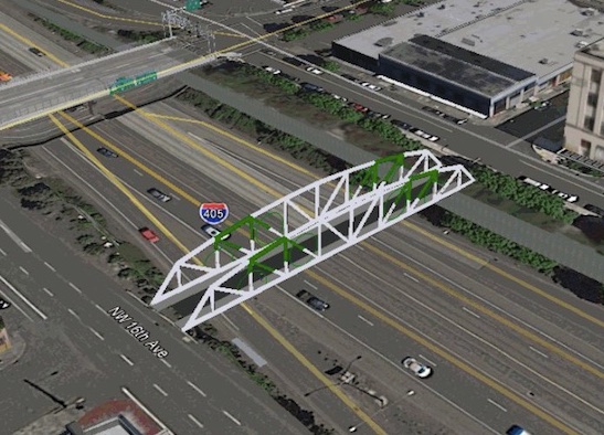
A bridge that will allow people to walk and bike — but not drive — over I-405 at Northwest Flanders just came much closer to reality. The Oregon Transportation Commission has approved $2,877,000 for the project through the state’s Connect Oregon funding program.
The award means the City of Portland is on track to start construction of the bridge in 2018.
“”We think a project like this will grow our economy and continue to make the downtown area the economic hub of the region.”
— Dylan Rivera, City of Portland
The Flanders bridge was one of 39 “non-highway” projects from all across the state to receive a total of $49.5 million in funds generated by lottery-backed bonds.
The total cost of the Flanders project is estimated by the City of Portland to be about $6 million. The Bureau of Transortation has already pledged $3 million for the project — which it intends to get from system development charges (fees paid by developers to mitigate transportation impacts). And no, in case you’re wondering, a pending lawsuit backed by developers and the Portland Business Alliance against the city’s use of SDC funds does not impact this project.
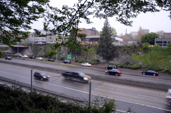
This is great news for the northwest Portland bike network and once the bridge is completed it will also mean this part of town will have its first ever neighborhood greenway. Flanders is currently well-positioned to be a bike-priority street, but it lacks a crossing of I-405.
Portland leaders have been working for over a decade to close this gap. Former mayor Sam Adams first proposed the idea of a new bridge over Flanders in 2006 when he was PBOT Commissioner. He continued to work on the project until his run for mayor in 2008 but was not able to make it happen.
Advertisement
(Photo: M. Andersen/BikePortland)
According to the city’s grant application, the bridge would likely average about 3,000 crossings as soon as it opens as people shift their routes from the busy and high-stress crossings at Everett, Glisan and Couch. Once greenway elements like speed bumps, signage, and diverters are added to the street, it’s estimated that the new bridge would see 9,100 trips per day. That’s more than the amount of daily bike trips over the Hawthorne Bridge.
Given its low cost and high estimated usage (thanks to its location in dense northwest), we’ve reported that it could be the city’s best bridge project in years.
So far, PBOT is planning for the bridge to have a 24-foot cross-section evenly split with two six-foot bike lanes in the middle and six-foot wide sidewalks on each side.
PBOT sees the bridge as a crucial centerpiece in their goal to reach their climate change goals and the 25 percent biking mode share laid out by the 2030 Bike Master Plan. The bridge would connect the Pearl District to Northwest Portland, two of the most densely populated neighborhoods in the Pacific Northwest.
City spokesman Dylan Rivera says the project is also about economic development. “Every week we hear about another software company moving here from the suburbs and citing bike routes, public transit and food carts as the reason they need to be downtown,” he shared in a phone interview today. “We think a project like this will grow our economy and continue to make the downtown area the economic hub of the region.”
The OTC also chose to fund several path projects including the Tigard Street Trail ($700,000), a bridge on the Yamhelas Westsider Trail in Yamhill County ($1,000,000), a segment of the Waterhouse Trail in Tualatin ($400,000), and a multi-use trail in Kronberg Park in Milwaukie ($1,185,000). See the entire list of projects here (PDF).
UPDATE, 3:06 pm: Here’s a news release about the project just sent out by PBOT.
— Jonathan Maus, (503) 706-8804 – jonathan@bikeportland.org
Our work is supported by subscribers. Please become one today. You can also make a one-time donation here.


Thanks for reading.
BikePortland has served this community with independent community journalism since 2005. We rely on subscriptions from readers like you to survive. Your financial support is vital in keeping this valuable resource alive and well.
Please subscribe today to strengthen and expand our work.
Great news!
I know that’s just a general idea of the crossing, but dare we hope that a slightly prettier design wouldn’t cost extra?
too soon anne. too soon. let’s celebrate!
seriously though… I’m sure the design is likely to be tweaked a bit. construction won’t start for another year at least and you know how PBOT loves its public process.
Lemme get my hardhat and we can start it tomorrow. Who’s got a cargo bike for the steel beams?
Glad this is a PBOT project, not state-level.
Given this is being funded by the state rather than the city, we can expect a well-designed bike project for once. There is a marked difference in quality between bike projects funded by state or federal vs. ones funded by the city.
Do you have examples? NE Cully? SW Multnomah? Rose Quarter Transit Center?
SW Moody is the best cycling facility in the city and it was paid for by federal funds. Compare this to any greenway project where PBOT struggles to find the funds for diverters. This is because city council eviscerated PBOT’s funding for cycling projects.
Have you seen the section of outer-NE Sandy that ODOT remade a few years ago? 6ft bike lanes with a white rumbly stripe separating you and 50mph traffic…
Yes ! Build an entire cap over 405 !
Yes, please.
I recall reading about a freeway that was covered over in Germany. As I recall, they made the cover into a park. It was years ago, so I don’t recall any details, like which city.
http://www.vox.com/2015/1/9/7520805/hamburg-highway
From what I understand, sunken highways that get covered can’t accommodate structurally sound foundations for buildings of significant size, so they’re often made into greenspace. This was done in Boston as part of the ‘Big Dig’, and it fits well with the approach that Frederick Law Olmstead (sp?) took in the earlier days of building that city (i.e., with the Fenway).
Also part of the I-90 east of Seattle has short lid sections with parks, but these were installed as part of the project as a result of a lawsuit.
That’s pretty common in Germany actually. Here’s four examples in Düsseldorf:
https://www.google.de/maps/place/D%C3%BCsseldorf/@51.1944201,6.7873504,1883m/data=!3m1!1e3!4m5!3m4!1s0x47b8c97bf1465907:0x42760fc4a2a73b0!8m2!3d51.2277411!4d6.7734556
https://www.google.de/maps/place/D%C3%BCsseldorf/@51.2296151,6.7395895,940m/data=!3m1!1e3!4m5!3m4!1s0x47b8c97bf1465907:0x42760fc4a2a73b0!8m2!3d51.2277411!4d6.7734556
https://www.google.de/maps/place/D%C3%BCsseldorf/@51.2745891,6.8285885,940m/data=!3m1!1e3!4m5!3m4!1s0x47b8c97bf1465907:0x42760fc4a2a73b0!8m2!3d51.2277411!4d6.7734556
https://www.google.de/maps/place/D%C3%BCsseldorf/@51.273773,6.7650722,942m/data=!3m1!1e3!4m5!3m4!1s0x47b8c97bf1465907:0x42760fc4a2a73b0!8m2!3d51.2277411!4d6.7734556
And the North end of a fifth one for a four lane highway that is too long to see in one pic, but runs right along the river all the way through town.
https://www.google.de/maps/place/D%C3%BCsseldorf/@51.2301135,6.7706686,476m/data=!3m1!1e3!4m5!3m4!1s0x47b8c97bf1465907:0x42760fc4a2a73b0!8m2!3d51.2277411!4d6.7734556
It comes out here:
https://www.google.de/maps/place/D%C3%BCsseldorf/@51.2150382,6.7600142,235m/data=!3m1!1e3!4m5!3m4!1s0x47b8c97bf1465907:0x42760fc4a2a73b0!8m2!3d51.2277411!4d6.7734556
They also did this in Boston and Dallas.
Excellent! Hopefully between now and 2018 we can advocate for and get signals/better crossings at NW 16th and NW 13th.
sorry *NW 14th
For the amount of bike traffic this bridge is expecting, six foot bike lanes are not wide enough. Should be closer to 8 or 10 feet.
Yet another example of planning for failure. Six foot is pretty much a minimum standard. If we anticipate success, the lanes should be at least eight feet and probably wider. Once one is building a bridge, it takes a lot less money to build in some extra width at the beginning than it would to retrofit it later.
If PBOT is somehow wedded to the 24 foot width, perhaps a single eight foot sidewalk could suffice so the bike lanes could be eight feet as well.
24ft is just too narrow.
SW Park Ave has the most quiet connection over 405.
It will be interesting where the money for 6+ 4way stoplights come from on the Flanders route so bikes can go both directions on the bridge. 16th and 14th are both nearly gridlocked with cars and trucks. Oh! that is right when gridlock occurs bikes and peds can cut between.
Only works on rush hour.
The cost estimate includes a signal at 16th and a marked crosswalk at 15th. Funding still needs to be identified for signals at 14th and Broadway, but there’s a certain Central City Multimodal Project you may have heard about that could potentially fund them…
The NE 7th Ave bridge over I-84 will also be massive in finally making a comfortable north-south connection on the eastside. The Flanders bridge plus a 7th ave bridge would be transformative.
I really want to read that headline about a NE 7th bridge over I-84 too!
Yea! I ride flanders nearly every day and have to get on Everett (hate it!) to cross 405 then get back on flanders to 3rd into the office.
Flanders on the downtown side of 405 needs some improvements in their street infrastructure to help bikes (green lane similar to Oak).
But 2018! Come on Man! We take forever to do anything anymore. MAKE IT NOW! 🙂
The PBOT says on their Facebook page that construction of the Flanders St. Bridge should start in April 2018. Let’s hope it’s well designed enough to do the job, and look nice, too.
I hope BikePortland will keep us informed about how/when we can provide input!
Yeah, they updated the presser to have that date too.
I’m kinda surprised the railroad overpass in North Portland wasn’t reported on: Union Pacific Corporation & Subsidiaries – Portland Passenger-Freight Rail Speed Improvement Project $8,294,124.
This project was often cited by UP as a precondition for their consent towards using their right-of-way for the (geographically unrelated) Sullivan’s Gulch MUP. Maybe that $26 million project can now start to move forward again, as well as the 205 T-HOP underpass.
The I-205 Underpass is funded, and scheduled for 2020 or 2021. It doesn’t require use of any Union Pacific right-of-way.
Most of the rest of the Sullivan’s Gulch Trail, however, does go through their right-of-way, and I’ve not heard anything to indicate they are going to soften their stance just because they had a successful ConnectOregon application for unrelated rail improvements.
During the few times that UP officials were willing to talk with PBOT and ODOT (both of whom UP treats with equal contempt), UP wasn’t willing to abandon the Sullivan’s Gulch rail corridor unless they could get the flyover in North Portland (over rival BNSF tracks) funded and built first. The conversations took place during the UP-owned Steel Bridge bike span negotiations and later when Metro approached UP about the bike trail, several yeas ago.
(deep breath)
woooooooooohoooooooooo
Yes!!!
It had better come with diversion, and lots of it.
So many drivers take NW Flanders all the way up, to connect to NW Westover street, to avoid the bottlenecks on Cornell. It’s currently not a great bike street, I’ll say that.
http://web.archive.org/web/20080422231929/http://www.commissionersam.com/sam_adams/2006/03/input_wanted_sa.html
“In the end, the price tag for the overall project is probably within the range of $3 to $5 million. Building a 12 foot pedestrian bridge from scratch would only cost between $1.5 to $2 million. This would be similar to the bridge that is currently being built over McLoughlin Blvd.
But, If we were to build a bridge with similar dimensions to the Sauvie Island bridge, that would cost between $12 to $14 million.”
We could have had a 40′ right-of-way for $5M, and now we’re getting a 24′ ROW for $6M+. It was a terrible missed opportunity, and it was the start of Sam’s loss of bike community support.
You need to account for inflation.
Inflation has been relatively low since the recession. $5M in 2006 dollars (when the linked post was made) is now $5.92M.
Exactly, so the costs cited above are the same, the difference would then be a 40ft wide old bridge that would collapse in an earthquake vs. A 12ft wide new bridge that will survive one.
Rough cost estimates include inflation, plus several line items for “contingencies”.
Watch for Flanders-to-waterfront connectivity (yay!) as part of this project, but including (concerning) closing of Esplanade path crossing of tracks and cramming bikes, peds and Naito all between the Steel Bridge footings, and a “million dollar median” in Naito also there.
Boy Scott, you seriously have a one-track mind about all this. Calm down and enjoy this accomplishment. Your concerns will be heard soon enough.
Hood River needs a bike/ped crossing for the Columbia River…
I think this everytime I’m visiting Hood River and would want to check out the orchards above Lyle on the other side of the river. 🙁
Is this the same location that the old Sellwood bridge section would have fit? If I recall it would have fit perfectly (almost miraculously so), right down to the inch. The rendering of the new crossing that’s going over 405 looks very similar to that Sellwood bridge section that was instead barged off and scrapped.
You’re thinking of the Sauvie Island bridge.
Just for fun, I decided to show the scale of what the Sellwood Bridge in Downtown might look like.
Link to image: http://i.imgur.com/7KXrgD4.jpg
Jack, that would actually make an awesome bridge for bikes. I’d love to ride OVER 14th and 16th avenues instead of having to cross them.
I like what you’re thinking here. An overpass of 14th and 16th is a win-win for both bicycles and freeway-bound motorized traffic!
What PBOT is showing is a an ARTIST’S rendering, not a preliminary ENGINEERING design. A structurally feasible design probably could not rest on the two big retaining walls that define the freeway canyon.
We have seen misleading visual designs before, namely for the Tillikum. Followers of BP “Craved the Wave” that had been created by a “bridge architect,” but which could not have supported its own weight. The cable-stay that was actually built was proposed by TriMet’s consulting engineer.
Structural engineers are eminently capable of aesthetic as well as technical excellence. Surely we will get both in the actual design.
It would be nice to use something like 1/4th the Tillicum design with a single post in the middle of the freeway. The stringers could be either in the middle or staggered to each rail on the side. This would eliminate the stress on the concrete walls on both sides of 405.
Flanders will need 4 way stop lights on 13th, 16th, 18th, 19th, 21st, 23rd, 10th, Broadway, 5th, and 4th. Bikewalks on every other intersection with enforcement. There will be parking on both sides of the street.
Personally, I am sticking to Johnson westbound and Everett eastbound, staying in the traffic lane when there is no bike lanes.
Awesome. Though I think much focus will need to be on the quality of the 16th Ave and 14th Ave crossings. And traffic calming on Flanders will need to be greatly increased for the additional bike traffic. Curious how this plays into the new Everett bike lane in NW and future Glisan bike lane in NW, will there continue to be both options (Everett/Glisan and Flanders Greenway)?
Greenspace > freeway
North End Park and The Greenway is what I was referring to. When I was in college here, this was a highway dividing the city (not unlike I-405). I was back there last year for the first time in ages; so much nicer now!!
https://goo.gl/maps/j9t4KbuXXpE2
Capping the 405 would be excellent, even if only portions are capped. Glisan to Burnside would be nice, so would 4th to Park. Even though the freeway is sunken grade and not particularly difficult to cross over, it is quite the physical barrier that does literally nothing for surrounding land values. Being one city block wide and carving its way through the central city, it seems quite out of place for a city that prides itself on livability. Downtown, the pearl, and NW are expensive because of amenities and demand for a lifestyle that those neighborhoods offer. Neighborhoods all over the country were split apart and fell victim to blight as highway construction went rampant, Portland was no exception. It seems as though it’s high time to do something about it!
Don’t get me wrong I think this is a great thing for the city’s bicycle network, but it is so shortsighted in the long run. That whole area over 405 should be capped. It could be so much more.
Capping a sunken freeway is the same as constructing a bridge over it – most of the structure is there to support the structure, not the load.
Capping I-405 is a 100x more expensive project.
Go big time !
Wasn’t capping it Vera’s idea?
Will the bridge have a name?
Flanders Crossing, obviously! With a statue of Ned Flanders, hopefully.
Alternatively, if someone wants to sponsor the bridge to make it prettier and wider to satisfy BikePortland commenters, we could name it after them. Maybe Providence Bridge, to go along with Providence Park? Or Timbers Crossing? BikePortland Bridge?
Great news…though don’t forget to set aside space for a foodcart or two…