(Photo: M.Andersen/BikePortland)
Southeast Portland has always been the heart of Portland’s biking culture. But as the last few weeks have made horrifically clear, it’s still full of problems.
In an article published Friday on the Southeast Uplift neighborhood coalition’s website, a new member of that organization’s board laid out three concrete and seemingly achievable suggestions for making the area a bit better — as well as a perceptive theory about the recent problems on Southeast Clinton Street.
Terry Dublinski-Milton, who several years ago created his own neighborhood-greenway-focused bike plan for the city and has since become active in the city’s formal neighborhood association system and the advocacy group BikeLoudPDX, had this to say about three different needs of the big swath of Portland south of Interstate 84 and west of Interstate 205.
Clinton-Woodward Bikeway
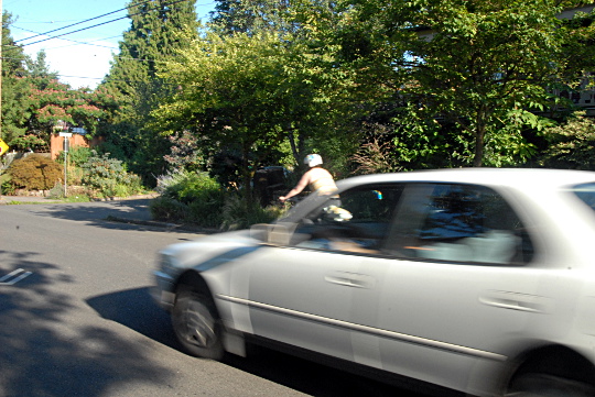
Clinton Street is one of Portland’s oldest and most well-established bikeways. Unfortunately this once-lauded and always popular bicycle route is troubled by safety and equity issues. Parts of Clinton handle over THREE times the number of vehicles daily than they should according to national standards for auto counts on bike boulevards. Previously this wasn’t as much of a problem because there were big gaps where bikes could move to the side.
Now that Division St is a trendy destination, visitors are increasingly parking on Clinton and drivers are using Clinton as a convenient (few stop signs) cut-through during peak commute times. This has created dangerous conditions for bicycles as drivers try to pass without adequate space to do so safely. To reduce conflict and modernize this critical bikeway, I believe the City should install diverters that would direct cars back to the arterials.
To the west there is the Tilikum Crossing, a world class active transportation bridge, yet to the east the Clinton-Woodward bikeway ends in gravel with no residential connection to the Green Line Division MAX station or I 205 path. Completing Clinton-Woodward, MAX to MAX, would create a central residential safety corridor for all of SE Uplift which would physically show we really do care about equity, while we connect SE Uplift including the forgotten “Middle East” of Portland between 60th and I 205 together. This would be good for all of us.
(Photo: M.Andersen/BikePortland)
Dublinski-Milton’s point about Clinton becoming a worse place to bike in part because its parking spaces have become scarcer isn’t backed up by hard data (not that I know of, at least). But it squares the city’s argument that traffic volumes on the street haven’t changed much with Clinton users’ contention that the street has recently gotten much less bike-friendly.
His use of the phrase “Middle East” to describe the mostly gridded but more auto-oriented area between 60th Avenue and Interstate 205 is also useful. Whether or not that language takes off, this part of Portland is likely to see big changes in the next decade and is going to need a name.
Interested in fixes to Clinton? The City of Portland hasn’t counted of traffic volumes on Clinton since the Division streetscape project finished, but the neighborhood group Safer Clinton is conducting its own rush-hour counts tomorrow in order to gather data before the end of the Portland Public Schools year. If you can help out between 7 and 9 a.m. or 4 and 6 p.m., email your preferred shift to schlosshauer@gmail.com and show up at the time planned.
Advertisement
20s Bikeway
The 20s Bikeway – a 9.1-mile route that goes from Lombard Avenue in the north to the Springwater Corridor in the south – is funded for this fall. Here we have a rare opportunity to build in a fix to Clinton: engineer diversion near 28th on Clinton as part of this bikeway. This small improvement on the 20s bikeway, which connects Hosford Middle and Cleveland High Schools, would solve two problems at once: creating a safe, low traffic, north-south bicycling corridor while concurrently creating safer conditions on this stretch of Clinton through traffic reduction. This is just one possible improvement, but working together SE Uplift, neighbors, businesses, and neighborhood associations can help make sure the 20s Bikeway is a genuine world-class bike facility.
Almost two years after planning began, the poor bedraggled 20s Bikeway Project is looking like a federally funded photocopy of a photocopy of a photocopy. But Dublinski-Milton’s suggestion for leveraging its money and process to fund a crucial bit of diversion on Clinton is interesting.
60s & 80s Bikeways
There currently is a large gap in our north-south bikeway network that spans the SE Uplift coalition area between the 50s and I-205. Over the past months, I have worked with neighborhood associations and individuals to network the “Middle East” of Portland into a series of priority bikeways including the 60s from the 60th MAX station to the Springwater via Mount Tabor Park and 80th from Madison High School south into Brentwood-Darlington. These have been endorsed by a number of neighborhood associations and are on the planning maps, but we need to call on City Hall to get them built. Each of these bikeways cross Clinton-Woodward and will integrate nicely into the 2016 SE Foster Roadway safety modernization, thus supporting this growing commercial corridor.
The 60s and 80s bikeways are essentially neighborhood-driven variations on the jagged neighborhood greenways sketched into Portland’s 2010 bike plan on either side of Mount Tabor. As Portland waits (and waits…) for some sort of bike access on 82nd Avenue, the 80s bikeway in particular could be a decent interim alternative. Here are Dublinski-Milton’s homebrewed Google maps of the routes:
Interested in learning more about it? Dublinski-Milton, joined by city transportation staffer Zef Wagner and others, is leading a Pedalpalooza ride (Facebook, Shift) south along the 80s bikeway from Madison High School south to the Cartlandia food cart pod.
With Portland’s biking problems feeling as pressing as they ever have, these ideas are worth talking about. It’s nice to see a neighborhood coalition giving them a platform.
Disclosure: I serve with Dublinski-Milton and others on the board of the North Tabor Neighborhood Association, largely because I was impressed by what he was getting done for our neighborhood. We don’t always agree, of course.


Thanks for reading.
BikePortland has served this community with independent community journalism since 2005. We rely on subscriptions from readers like you to survive. Your financial support is vital in keeping this valuable resource alive and well.
Please subscribe today to strengthen and expand our work.
Thank you for the recognition Michael and keep up the good work!
Thank you for all your effort and great energy, Terry!
You are welcome and Thank you…..I can plan and work the system, you can use the megaphone!!
Thanks, Terry, for doing these maps! I got a kick out of some of the comments. Hopefully PBOT listens and implements these suggestions for Clinton. Having recently moved near the SE 52nd and Woodward intersection, I am appalled at the behavior of some of the drivers on Clinton. One person even yelled at me that “I’m the reason everyone hates bikers”!
Speaking of 52nd, despite it being new, there are still many improvements to make. Why is there only a diverter going north at Division and not south? The bike lanes should really be protected or raised instead of just paint – lots of people drive way too close to the bike lanes. The northbound lane already had car parking removed and was built along the curb. It wouldn’t bee too much more effort to make it raised. Also, the lanes get more and more narrow the closer you get to the Springwater Corridor.
Regarding driver who yelled at you…..Maybe there should be signs for car drivers that say something like “Clinton Greenway: bicycles have right to full use of lane”.
My own opinion, as a daily Clinton rider, is that I don’t mind drivers having a choice to use Clinton to avoid a plugged up Division or Powell IF, IF, IF they accept that the price of doing so is that they may have to go at bicycle speed for much of the way. I see the problem as one of attitude; specifically, the expectation/entitlement of being able to reach a certain speed. It may feel painfully slow but you’re really only getting home a minute later because it’s over such a short distance (and the bonus is: nobody had to die).
Isn’t that the point of the sharrows? You wouldn’t think they’d need anything more than that (and, you know, the law) to remind them. But maybe you’re right.
Agree on the second part, but that’s the huge (and currently not true) if. What about instead of diverters, some serious speedbump treatment? Substantial and frequent enough to make it unpleasant but possible to drive (at slow speeds) and with gaps for bikes to pass through.
I’d bet you my last nickel that the people yelling at bikes on Clinton don’t know what sharrows are and don’t even know where to find Oregon statues.
It’s the same sort that yells and honks at pedestrians crossing in the crosswalk. Car people are the most important people.
They are enraged because those unmotorized folk around them are having more fun, and are not in debt. They realize, subconsciously, that they were sold a bill of goods and so they lash out.
On the really rainy, thunder stormy days when I drive to work, for the mile or so that I’m on Clinton (which our office is off of) it’s extremely satisfying to stay at an appropriate speed and educate the impatient cut-through drivers who are forced to follow my lead.
I don’t think speed bumps are ever an effective treatment unfortunately. The speeders fly over the gentle bumps, suspension parts be damned, and the bumps that are abrupt enough to be effective are rough on bikes.
Speed bumps like NW Lovejoy above 30th. perfect for bikes at any speed. cars are airborne over 25 comfortable at 10.
The hyperbole needs to stop. PBOT would not install speed bumps of any shape that cause motor vehicles to become airborne at 25 mph.
NW Lovejoy above 30th? New to the area? Cornell Road speed cushion test data place the auto 85th percentile speed at 27-29 mph (2013 counts) on the 25-mph street.
Why are you driving a mile (20 blocks) on Clinton? Shouldn’t you stay on Division or Powell until you get to the cross street nearest to your office? Your answer probably explains why so many other drivers choose to do the same.
It’s about 15 blocks, and I live south of Clinton, so I would have to overshoot to hit Division, and I don’t spend any time on Powell, I just cross it, I would have to explicitly turn onto it to end up using it.
I take it you’ve never actually been on Powell since you’re asking me why I don’t use a suicidal truck infested highway with no exits?
“I don’t think speed bumps are ever an effective treatment unfortunately…”
Agreed. I haven’t found a speed bump I like (in my automobile) yet, at any speed. They’re also damaging to emergency and heavy vehicles, especially fire trucks. And if you’re a patient in an ambulance with a paramedic trying to insert an IV, do you want that to happen just as they’re going over speed bumps?
Well, if the ambulance doesn’t like speed bumps, it’s really going to dislike the diverters. It’s a pretty exceptional circumstance to design a side street for.
Diverters that admit emergency vehicles are nothing special or new. When I lived in Berkeley in the nineties they were all over the place. I don’t see why we couldn’t have those here.
Concrete planters evenly spaced across the two lanes, with a gap in the middle, and an inverted U welded out of large diameter steel pipe set into the asphalt. It is high enough off the ground to discourage people in cars to try it (even though they probably would make it), and the ambulance & fire truck drivers already know they can clear it.
Show us a picture. What about cyclist striking that low object at night? The other thing is we live in the land of SUVs and oversized trucks.
Those vertical delineators added at 13th and Spokane aren’t there for decoration. Even the unmountable curb at Going and 15th is getting run over.
Scott H,
Any studies to support your supposition on speed bump effectiveness?
Just my opinion, based on what I observe every day.
Speed bumps made a big, positive impact on SE 21st.
Sharrows are the abstinence-only sex ed of bicycle infrastructure, They make some people feel good that they are “doing something” but they have never been proven effective at preventing wrecks or driver intimidation of cyclists. They are a waste of time and money. Good drivers don’t need them and bad drivers don’t see them, or understand them if they do see them.
I don’t want cars on the bikeways except for local traffic. At least not unless parking on one side is removed to give extra room. All types of people are cycling through these corridors at varying speeds; as a more experienced cyclist I don’t want to be stuck going 5mph behind a less experienced cyclist because there’s a car in front of me and oncoming car traffic making it too dangerous to pass.
And on the note of speed bumps – they don’t really work on Ankeny. Not only do drivers simply speed between them, but they are annoying to me as a cyclist because they have a slowing effect on me while I’m already going slower so I have to work harder.
Speed bumps also generate significantly increased noise from the suspensions squeaking and acceleration of aggressive drivers trying to make up that “lost time”.
There’s a similar effect from adding extra stop signs. Instead of calming or slowing traffic, it tends to put drivers into “connect-the-dots” mode where they go from one sign, accelerate hard and brake hard to the next sign, accelerate hard and brake hard to the next, etc. They drive point to point, paying even less attention and being even more dangerous in between each.
Any studies to support your supposition?
Don’t expect attitudes to change in a meaningful way during a time of heavy in-migration.
To be honest, I don’t really think it’s the proverbial “Californians” that are causing this. (Insofar as there is any one causative agent; there’s not one, there are many.) Even though the claim of “bike paradise” spun by the city and popular culture is vastly overstated these days, some people are still moving here because they want a place where they can — with okay infrastructure by North American standards and some modicum of cultural acceptance — ride bikes. I moved here 7 years ago in part on that promise — and to go to school, I guess 🙂 — and I know there are others like me.
On the contrary, I think in-migration can have untold positives as it pushes at the values of the old guard: the folks who cling to their “right to park” in the ROW outside of their single-family craftsman, the old time business owners that protest against bicycle lanes on commercial streets, the people who feel a diverter is a huge burden on their engrained navigation of the city. Not being an apologist for all the changes wrought by the boomtown mindset of the last few years, and definitely not saying everyone here is some sort of caricatured “old guard,” but just chiming in to say that new people have a tendency to mix things up.
“Oh, the farmer and the cowman should be friends…” 🙂 I’m one of those cussed born-and-raised Portlanders. Apologies for the diversion–I appreciate your efforts, Terry! Thank you!)
Portland’s auto traffic is particularly awful because of the odd mix of horribly conflicting driving styles of various immigrants and long-timers. My experience (before ditching the car altogether) of driving in Portland in earlier years before it was flooded with newcomers was that long-time Portland drivers were/are good drivers. But, we all decried WASHINGTON drivers as the bad–slow, didn’t know how to use the passing lane, generally no good. 🙂 Then, a lot of California drivers–fast, impatient–moved in, then MIdwest, then etc. etc. etc. So now we have this bizarre mix of fast, slow, tailgating, stopping in the middle of the road for no reason, aggressive, passive, aghghhhh! It really was a deciding factor in our getting rid of our car.
Portland’s bike mode share is mostly attributed to people moving here that want a bike friendly city rather than people getting out of their cars.
52nd is a different street north of Division vs. south of Division. North it is a residential street (which job/dead ends a few blocks later). South it is an arterial (that continues all the way to Johnson Creek). Thus I’m guessing that it made little sense to divert traffic both ways.
52nd may look different, but it has the same traffic classification north of Powell as north of Division – Local Service Street. It is south of Powell it becomes Neighborhood Collector.
To solve the south bound car problem we would need an eastbound diverter at 50th and Lincoln, that intersection needs to be modernized to look like Caesar Chavez as it is with the traffic counts we have there. It may not take it all away, but alot…..you can watch them from the corner use it as a cut through.
Is there a “south bound car problem” though? Don’t we want to funnel cars onto our arterials (even if it isn’t technically designated an arterial here is it is used (and built) as one), and keep them off the neighborhood streets?
I have seen traffic patterns shift a bit, as drivers are realizing the new signal changes at 52nd and Division have resulted in that route being slower than 50th and Division.
A diverter onto what is essentially an arterial just seems like a bad idea to me.
Raised bike lanes would be nice, but they’re very expensive. There are lots of other priorities for expanding the bike network (such as the ones Terry highlights above) before we start raising existing ones.
Terry is a bike advocacy force of nature!
“but we need to call on City Hall to get them built”
The city recently eliminated local funding for new greenways.
http://bikeportland.org/2014/02/28/special-report-how-portland-stopped-funding-neighborhood-greenways-102274
If you want to see Greenways improved and expanded, please let the mayor and Portland commissioners know:
mayorhales@portlandoregon.gov
Nick@portlandoregon.gov
amanda@portlandoregon.gov
commissioner-novick@portlandoregon.gov
dan@portlandoregon.gov
BikeLoudPDX and Bike PSU are speaking about bike infrastructure at City Hall at 9:30 am on June 24. If you support more and better Greenways please consider attending the rides (8:00 am, 4:30 pm) and rally (8:30 am).
http://shift2bikes.org/cal/viewmonth.php?month=06&year=2015#24-5016
http://shift2bikes.org/cal/viewmonth.php?month=06&year=2015#24-5013
Roger Geller (PBOT Bike Coordinator) on how Portland could regain some its Bike mojo:
[It] “would be great if we had even 200 people in front of City Hall holding up signs.”
I am making a sign that has the Roger Geller quote on it and will do just what it says. See you on the 24th!
I briefly went through the maps and agreed with many points he made. Specifically the park near the Parkrose TC.
And Trimet could build a bridge connecting this new park to the Parkrose TC, greatly increasing the walkshed of this under-utilized transit stop.
Agreed 100%. There’s a whole neighborhood right next to a train station / TC that they can’t even access! Parkrose used to be my transfer when I lived farther East and it was pretty much always a hassle. Usually, the line 21 bus would be just late enough that I would miss my transfer to the train and have to wait 15 minutes for a train, or transfer to the 12.
I would love it if there was a “North line” BRT or LRT connecting St. Johns area to Troutdale and Gresham along much of the industrial / lower income housing. It would be a great way to connect people to jobs. (which could get rid of the need for an infrequent line 21).
Sorry but I think going OVER mt tabor as part of a bikeway isn’t a very good idea. I think of these routes as being easily commutable, and the steep incline outlined on the map isn’t very great. Given that there is a 50’s bikeway already, I think the right alternative to lobby for is a 70’s bikeway, which could start as far south as the Springwater trail. For it’s Tabor section, the relatively slow incline of 76th is ideal, and the only hairy part of the engineering here is the jogging needed at Washington/Stark to 75th (or 74th) and getting back to 74th at Burnside to reach the lights at Glisan, Halsey and the I-84 overpass. Here the route can continue north as far as Killingsworth/Portland Hwy.
Like seemingly all of the N/S bikeways that do exist, there will be jogging between about 72nd and 76th, but with good signage, some road improvement, and paint,the 70’s bikeway is really a great option we don’t want to overlook.
I totally agree, I’m not training for the Tour de France, I just need to get around town. I’d much rather have a 70’s bikeway instead of the 60s route.
Long term a path can be built just to the east of the reservoir, This route is actually the least steep grade on the north side and would be CHEAP to build as it is on street…the old logging road with little traffic. The western path, would have to meet historical standards and have ROW buy up issues between Yamhill and Belmont. On The North Side, our eastern half of the neighborhood, and western Montavilla does not have ANY way to safely get to Mount Tabor park currently. This route even made Metro’s new map. We are a lower income neighborhood 60% renters and need to get to the park and MAX.
http://www.oregonmetro.gov/tools-living/getting-around/bike-there
I have taken at least five groups rides on it, it works and gets you from the MAX to the park the safest and least steep way possible.
Should we differentiate the notion of access to the park and trying to make the easiest North-South traverse? Seems like a 70s plan would be the least out of the way elevation gain than a 60s plan. I certainly could see the 60s plan for being the Mt. Tabor access point.
The route using Harrison is actually not that easy and I would suspect a deterrent for many, who would likely pop over to 76th which many do now.
The route shown through Mt Tabor is much too hilly to be a practical bikeway. For a group ride, fine, but ride that towing kids on a trailer, bags of groceries, in work clothes trying to get to a meeting non-sweaty, as an 8 or 80 year old – not at all suitable.
Then why do I see families in my neighborhood using it now? I am the NA chair, and this has gone through three consensus run NA meetings over two years…but I guess my eyes could be wrong…
Admittedly it would never get the full on use that Clinton does…..but every neighborhood deserves access to SE Uplift’s centerpiece park…particularly a neighborhood like mine which has over 10,000 residents per square mile and will get hit HARD by multi-use buildings soon. We also have no playground and no school of our own, though we do have a JAIL!
Because a bikeway is different than an access route to a neighborhood park.
A bikeway needs to be practical for people who are not riding for exercise or fun or to get to the park, they are simply trying to get from home to work or errands, maybe carrying work stuff or groceries or wearing jeans or dresses or rain gear, maybe newer cyclists or not in particularly good physical fitness or riding heavy bikes. Needs to be practical and easy enough that they choose to ride instead of drive.
Access to a hilly park is for people who are going out for exercise or fun, who are probably already somewhat fit, and if they are tired or carrying loads or riding a heavy bike or don’t feel like seating in rain gear, can choose to skip the park that day.
For example, I ride laps up Tabor many weekends, intentionally getting my heart pounding and legs tired. But when I’m slogging home late after a long day’s work with 20 lb of stuff on my back, riding up Tabor is the last thing I want to do.
“sweating” not “seating” although I guess they’d “sit” too.
A park, especially a particularly nice one, is every bit a legitimate destination. Bike ways are not just about running “practical” errands and going to the park is exactly the kinds of everyday activity that parents do with kids. .. What, you want them to bike to the store on the bike way but then drive to the park?
This “Bikeway” cost would be primarily crossings at Glisan, Burside and Stark which are just as useful for pedestrians. The route also has at least one possible rest stop location. I see, and have joined, walks with families on this route including grandparents. The curbs cuts would have to be upgraded.
What do I know though about my own neighborhood? I know I am sick of seeing children and famlies dodge traffic, this greenway solves multiple problems at once for all kinds of people.
Plus the arguement that if it is not good for everyone it shluld not be built is what auto drivers say about bike infrastructure.
That is 150ft extra climbing vs 60th (which could be pretty mellow with 25mph traffic, and should have no parking, no yellow stripes, and 2 big bike lanes.) If that doesn’t work because drivers can’t be held to follow the law, I guess it needs diverters. This should be no problem, because we’re a platinum bike city that works.
60TH has way too much traffic to do that to and the houses are too close together to ad ROW. Plus, your improvemts would cost more than the greenway would and we still would need the three pedestrion crossings at Glisan, Burnside and Stark At 62nd for numerous neighborhood reasons long dlcumented. The 150 feet savings is to get to the reservior, what if you want to go to the aplitheathre For summer concerts…or just use the playground? This route takes you right to it the gentilest way. Mount Tabor Park is huge….it has multiple acess points.
Yeah but what about doing traveling north from the south. It’s a bear, and sure on a group ride of experienced riders not much of a big deal. However on a cargo bike, a tag-a-long it’s another story, or an inexperienced rider its a bear.
I actually have been with cargo bikes going up to the top with MEGA speakers that were very heavy…admittedly it was on a drop out ride….
76th carries fairly high volumes because it has signals at both ends (Division and Stark/Washington, and diversion is not an option due to being a proposed Emergency Response Route. While it will always be a useful bike route, it’s not going to be as comfortable as most neighborhood greenways. It’s a question of priorities. Should the City design and build bikeways for people already biking (essentially formalizing an existing bike route with some sharrows), or should it try to attract new folks to ride bikes by building a whole new comfortable bike route?
Seems the emergency route is not as valid as it used to be in terms of diverters. There are electronic ones that would not slow down emergency vehicles. All the rest of the time, the bollard could be up and reducing the high, through traffic on streets like 76th.
There would have to be some allowance, I suppose, since a Tri-met bus goes along 76 between Stark/Washington and Yamhill.
Clinton has slowly become a real drag to bike down–heading westbound, cars pull out right in front of me from stop signs nearly every day. The drivers are largely clueless as to how fast bikes travel westbound–the hill makes it easy to maintain speeds between 15-20MPH. Sometimes cars will hurry to pull out in front of me and then travel slower than I was on my bike.
On top of that, drivers make unsafe passes into oncoming traffic and attempt to pass bikes through the traffic circle choke points all the time. Drivers tend to focus so much on getting through intersections before bikes get to them that they often don’t see pedestrians crossing, and then their car will get stranded in the middle of the intersection once they see the pedestrians and need to allow them to finish crossing.
There are also a lot more pedestrians crossing Clinton since parking on or near Division has become more challenging. Many pedestrians won’t look both ways–they’ll simply step into the road because they don’t hear a car coming, not realizing that there’s a bike they couldn’t hear and didn’t bother to look for.
I started commuting down Clinton in 2008. I didn’t use to worry too much about that stretch of my commute, but now I feel like my head needs to be on a swivel. I don’t think you can pin all of the blame on the development of Division, but it certainly hasn’t helped. Traffic is getting worse in Portland every year, and commuting by car down Powell and Division has become a nightmare. As it gets worse, it becomes more tempting to drive down clinton, despite it’s traffic calming devices. A diverter on 26th would help.
“Many pedestrians won’t look both ways–they’ll simply step into the road because they don’t hear a car coming, not realizing that there’s a bike they couldn’t hear and didn’t bother to look for.”
We need a law mandating fake engine sounds be emitted from all bikes, automatically activated any time the bike is in motion. European bikes may have a switch to temporarily disable the sounds during evening operation.
The 20s Bikeway needs to start happening yesterday.
Diverters on Clinton are even more overdue. It’s not even signed for 20MPH. I’m starting to get sick of drivers breathing down my neck from 39th to 21st and an easy-access holster for my U-lock is becoming a consideration. The center cannot hold.
I have longed for a route somewhat east of the 50s Greenway, but Mt. Tabor is a topological challenge. It’s hard to characterize anything that follows the south and east slopes of America’s largest urban volcano so near to the 70s as “low stress” or “60s”.
It is too hard to say if Middle East/Inner Orient/etc. would be taken as clever or offensive. Is there no play with the iconic buttes/volcanoes that stand above the area instead?
Chirgrin. Funny thought! 60’s and 70’s can be pretty steep especially in the winter. Could do what ODOT andf Max think of doing every time there might be a more direct rout over a hill. DRILL A TUNNEL OR 2!!!
Most of the 60’s in the south is actually flat and would provide local acess to FOUR neighborhoods with a total of close to 30,000 residents…so why is everyone so obsessed with building the cheapest center, to a park that is a recreational centerpiece and a gem of the city, as being a bad thing?
It is almost like you want to protect the mountain acess to the current western inhabitants who have good acess while I am just trying to give it to as many as possible in all directions while tieing schools and comercial centers togther with mass transit at the same time: Look at the BIG picture, not the center $100 K of a $2 million project….with much of the 1.3 Mill of the greenway going to pedestrian crossings. South, they are all affordible flashing beacons. Since Foster and powell are currently signalized, It just makes sense.
79th-80th will take some real investment even without the overpass, but is still do able if we are creative…that one is flat, and connects to the 60’s via Halsey-Multnomah, And Yamhill in the north…so there is a flater option, and acess to the mountain from all directions. All told including the completion of Clinton-woodward we are talking less than one mile of gravel roadway, on multiple small sections, that all could be small bike and pedestrian rest stops like Holamn city park. These could all be design locally as these areas are by 82nd and park poor, racially diverse and lower income than the city as a whole….as is North Tabor by the 60th street MAX station.
That is how you build alliances…..give something to everyone and connect them together so it is good for all of Portland.
We could put diverters mid-block. That way drivers can still easily access their homes but make it impossible as a thru street.
Which homeowner wants a diverter turning into their driveway?
This diverter was in front of my old place. It worked ok, but could work better with a bump in it.
http://bit.ly/1Gl8Iki
If you are closing the street to through traffic and forcing u-turns why put it mid block ? NW 17th dead ends at NW couch, they put up a bunch of big cheap pots, and banned parking near them to make sure there was room for cars to turn around. You could have something like that, just with gaps for bike traffic in both directions, and either a tree, bollard etc… to keep drivers from going on the sidewalk.
Diverters can take several forms. A 36-foot wide street can have 8 ft parking, 12 ft travel lane one way – shared with bikes, 8 ft parking, and a contra-flow buffered bike lane next to the curb.
Alternating this one-way shared/bike contraflow every other block would preserve access to each block, but stop through traffic along the corridor, except for peds and bikes.
Diverters on Clinton, yes, overdue. Taylor Gibson’s excellent presentation showed how diverters could help on Clinton… 2.5 years ago:
http://bikeportland.org/2013/12/03/big-ideas-from-future-transpo-leaders-will-get-spotlight-tonight-98007
Speed bumps with bike gaps are very good. Use the example of upper NW Lovejoy. Bikes and motorcycle police have no problems. Cars become airborne at about 25. 🙂
False statements make you less believable.
The issue with speed cushions is the gap permits motor vehicles to mute most of the slowing effect by placing one side of the vehicle in the gap.
That’s why the speed cushion test uses the shorter speed bumps instead of speed tables – to counteract the speed increases.
Which direction would you prefer people driving to shift, left or right, to align with the gap?
Every time I read something Terry’s written I’m impressed. Thanks for all the great work you’re doing Terry!
Chicanes are needed instead of speed bumps.
Yeah, I would think the ideal path for a one-way road where you really want to slow/detour cars would be a ‘sine wave’ shaped road, where there is a straight line path in the middle that is wide enough for bikes, but cars would need to zig zag back and forth.
Wonder if that concept could be applied for a two-way road, like chicanes, as you suggest.
Eek! A bunch more intersections.
Not on a single lane one way road. Just a slightly zig-zagged road with a bike lane that is painted in a straight line right down the center of it, ha ha.
How do you keep the people driving from the center? Paint won’t do that.
I guess it’s hard to imagine. Nevermind.
Though I do respect the work that went into these plans I would propose that both are scrapped in favor of the 70’s bikeway. It would be straighter, offer much better access to the whole Eastside between 60th and 205.
Something more like this
https://goo.gl/maps/MHbeq
Much of it already is on very bike friendly roads, and of Davis would still work from 74th to the 60th Max station, and this route also still would make the connection from 75th to the Division Max station. Not much needed in ROW issues, and overall much flatter than either of the two above options, and much cheaper which would open up funding for better crossing improvements at critical intersections, and improve east/west paths and greensways as well.
Plus it could run from Killingsworth to Harmony/Sunside
The fatal flaw with the route you show here is the dreaded Emergency Response Route. 74th from Halsey to Burnside, 75th from Burnside to Stark, 76th from Stark to Division, and 72nd from Division all the way down past Foster are all either now or proposed to be Emergency Response Routes. That means no diversion is allowed, and speed bumps (fire-friendly ones) can only be put in with permission of the Fire Bureau.
Overall I think this version of the “70s Bikeway” will continue to work as it has functioned for awhile, as a useful bike route for the confident cyclists. It will not be an all-ages neighborhood greenway due to relatively high volumes and speeds that can’t feasibly be mitigated because of emergency response. The 79th/80th route Terry shows is far more likely to succeed as a neighborhood greenway, since volumes and speeds are low already and likely to stay that way. It also has the advantage of providing closer access to destinations along 82nd Ave.
Sorry, I should have said “76th” from Burnside to Stark.
I don’t buy the emergency responder route, which opens up more of a street for responders- cars which take up most the street, or bicycles which take up nearly none and typically are more aware of what is going on around them.
the Stark/Division path is proposed to be secondary for ER, so speed cushions could be used.
On 82nd north of Division to 1-84 is almost all car dealerships or auto industry related businesses, and all are only 2 blocks farther away on my route than the proposed “80s” path with is just as much on the 70’s as the 80’s.
Sorry but the 80’s plan highlighted in the article, isn’t going to happen anytime soon, not to sound mean but it just doesn’t work. You might have been on a couple rides in the area, I’ve been out here riding bicycles for almost 20 years now.
Proposed new crossing for 1-84? Path through a public school yard (Madison High School – ask PDOT how well that idea worked with Davinci). Some of the existing streets lack pavement and sidewalks. And many of those roads get some pretty good cut through traffic as people try to avoid backed up lights on 82nd (a problem which some roads being unimproved actually helps). Not to mention the traffic that is in place from the car lots that use those streets as overflow parking, testing repairs, and test drives – you get more traffic on those streets than you think you do.
You think PCC is going to let you cut through? You don’t need a path to cut through it’s campus now, and they just finished building it, little late for that now. ANd it is bicycle accessible from all four sides.
What kind of crossings are going to be putting in 2 blocks away from some of the most dangerous crossings in the state? Most my path has access to existing lighted intersections. and a little breathing room from the 82nd intersections. Some might not, but I spent all of 5 minutes on the 70’s rough draft lines, it could of course be tweaked.
70’s path connects better to existing paths and greenways (something the 60’s path doesn’t do very well). Is straither and makes much more sense.
Emergency responder paths, ok..other than stark to division and the 1-84 crossing shift my path over a block this way or that.
So you think the 70’s won’t work though it’s flatter other than at the ends it’s within 100 feet in altitude difference, works with existing infrastructure, and can take you from Killingsworth to Clackamas.
You want a big project? how bout 70’s path with a new path built straight north from Killingworth to the airport, just one little strip of land to buy and you’ve got road the rest of the way.
The 70’s path get much more done on a lot less money, and puts the path in the center of greater populations on those neighborhoods, where they’ll be used much more.
PCCSE wants it, already discussed with them at the highest level. Madison high and the Parks’ department are talking about the path now (I heard that from PBOT), yes the four-six blocks of gravel roads are a problem, but could be solved by Holman city park type micro park investment. This route has general consensus, if more expensive…the 70’s did not and the city analyzed over 1200 public comments from SE Uplift and multiple neighborhood association letters.
I really tried to get consensus on the 70”s south of Burnside as well, but there was not as much support. People just did not comment on the TSP or come out to the NA’s drumming up support for it. We will see when the new TSP comes out what it looks like.
Holman micropark… Multiply!
I agree with you in NE….I personally do not care which route they use there….72nd is the most likely choice anyway as long as it is direct. It is SE that has the connectivity problems, NE is a grid until you get to Cully and the gravel comes.
The parking thing on Clinton is so perceptive! The only time I felt afraid on my ride today was when a U-Haul driver swerved around a parked car at me while I passed a parked car on my side. From the look on her face, she either didn’t see me or didn’t care at all.
Agreed! “Previously this wasn’t as much of a problem because there were big gaps where bikes could move to the side.”
It felt like it went from hardly anyone parking on the street to every neighborhood street in Portland absolutely clogged with parked cars, overnight. 2008–that’s when I noticed it. Ugh.
forget those suckers East of 205 ..it’s just a wasteland anyway .. we don’t even deserve sidewalks or representation.
Why are we seeing diverters and emergency response routes as anathema. They work very well together as I suggested above. Here’s a picture:
http://cdn.patch.com/users/569170/2011/10/T800x600/99218570b974263577e4d91d5325efa4.jpg
People driving in Portland are already going over the low curb at Rodney/Ivy and Spokane/13th, and the high curbs at Going/15th and 20th/Harrison. It’s unlikely the pictured design deters drivers much.
Now that everyone has put in their two cents…here is what my analysis is and why:
1) the 60’s is the cheapest of the bikeways, can be built NOW as Foster and Powell are already signalized and the path from Lincoln to Division is slated to be built. The southern portion (Division South) has been on maps for a long time.
The “Steepest Section” that everyone is concerned about is the absolute cheapest mile of the cheapest project of the projects (less than $100K from Stark into the park). from the 60th MAX station south to Belmont, North Tabor deserves bike access and a Safe route to School. It is the route locals use WITH THEIR CHILDREN NOW as no one voluntarily walks or rides 60th to access the business nodes or park to the south. The section through the park to Harrison, is also a bikeway on the map…plus, if SW ever wants any real greenways, we need to follow the Berkeley example and build a steeper one first, this one is only steep in a very few blocks. We need PEDESTRIAN crossings at every one of these arterials….they just happen to line up right for a bikeway as well. This area is also getting high density housing…it would be nice if they could access the new bike parking at the 60th MAX station that is getting built…or maybe they want to ride downhill to the MAX…and then bike home via Salmon?
So, this is a $2 million project TOTAL, with only one new HAWK (Burnside if we can not diet it…I would diet it) and flashing beacons and pedestrian crossings with almost UNANIMOUS endorsement along its entire way (At least 7 NA’s). It creates a MAX to MAX residential loop, yes based on the Mountain….but gives EVERYONE access, no matter what direction. This is a class equity issue.
2) The 70’s-80th…..In Montavilla and south the comprehensive plan, this is from PUBLIC COMMENTS which the plan received 1200 from SE Uplift alone…. was very clear that 78th-80th is preferable since PCCSE is in the center and the NAs want it. This was the dominant opinion of the public according to the transportation planners, so when the new TSP comes out there will be adjustments. This would be an active transportation development tool to tie together the lowest income High school district in the PPS system. Groups of high schoolers could ride past PCCSE to get to Madison High. This would create community, and may even help our ABYSSAL drop out rates.
Yes it would require a path next to the Golf Course and School…PBOT and the School and Park Planners ARE talking about it (coming from them, not me). There is a LOT of room to work with unlike at DaVinci. The new Overpass has been talked about a LOT, but of course that would be a separate high cost project down the road…for the near term it would be the dreaded 74th overpass to Multnomah. This project would also FIX the NE Halsey freeway spurt between 67th and 82nd. It would require a major federal investment like the 20’s, but PBOT planers are working on that.
South it would be expensive as there are three short gravel road sections (I have been on it block by block with other NA planners). These are either in park poor areas and could be turned into small micro-park bike rest stops (MY VOTE which I will talk about..think Holman city park), or just paved. This is the biggest concern from the engineer that looked at this proposal, which fills a gap in the 2030 plan. There are NO bikeways between 72nd and 82nd. This is the only way that the west side of 82nd can be safety accessed without a complete overhaul, which ODOT is not going to do anytime soon. If we want 82nd to develop over time in an NON auto oriented way, we need to start somewhere…….
So, the 70’s does not have consensus as we do not know what to do north of 72nd (we talked about this for months at SE Uplift and in multiple phone calls) and south of Foster it is just a bike lane striping when ever they can repave (no consensus on parking removal at this time)…so I went with the routes that had the most public support to create a network in an under served region of the city. This would be a game changer for this region of the city. It took me a year to gain this support and put it all together.
If you do not believe me GlitterBunnybikes, come join me on June 17th for:
MADLANDIA! to show it off. Cartlandia is giving us $1 off drinks and will have a Jazz Quartet waiting for us at the end of the ride!
https://www.facebook.com/events/103856209950911/104299913239874/
The unpaved section at Mill and 80th, where the street narrows dramatically, would make a great little micro-park! The other sections should probably just get paved like normal.
As Terry says, PCC is interested in making a formal bike route through their parking lot…not too hard, it just needs a ramp at the north end and some sharrows.
TriMet has already secured funding for pedestrian crossings at 79th/Division and 79th/Powell, so this project can take advantage of those to take care of two of the more expensive crossings needed.
A bridge over I-84 is not feasible in the short term, but the crossing at 74th could be made better with bike lanes, and Halsey could get a road diet to make that crossing easier.
PBOT and Parks (which owns the Rose City Golf Course) have agreed in principle on building a multi-use path on the east side of NE 72nd Drive through the golf course, should funding be secured.
A project has already been funded (and might be implemented already?) to put sharrows and speed bumps on 72nd and 77th from Sacramento to Sandy.
Another vote for 80th route, particularly from I-84 south to PCC. It puts kids adjacent to two elementary schools (Bridger and Vestal), and older students adjacent to PCC. It drops you right into the Stark/Washington commercial district, and right behind Milepost 5 and Hong Fat Grocery. It also allows for easy sightlines to determine where a good crossing at 82nd might be if you need to head east. There’s a crosswalk option at 80th/Stark which is really helpful on weekends, especially with kids.
I live along SE 80th and bike the neighborhood all the time. 80th already has MUCH more bike traffic than any of the 70s along this stretch. Cars expect heavy bike and pedestrian traffic along here, and for the most part, are remarkably courteous.
76th isn’t a good option in this area. SE 76th has speed bumps and consistently heavy traffic from Division to Stark (from both weekday commutes and weekend Tabor traffic). And when travelling north on 76th, crossing Stark is really awkward and unpleasant since you have to travel up Stark a half block or so before continuing north.
THat was my opinion of 76th as well when i first looked at it, hence why I explored 79th/80th.
My wife and I visited Vancouver, BC last weekend and were really impressed with the number of diverters on their bike routes. Here is an example:
They were all over the place. Every 4-6 blocks on most bike routes. They also had a few really nice protected bikeways in the downtown area.
I agree and called for that today at the emergency city hall meeting. That call, for major diversion especially on clinton was echoed over and over again.
‘Dangerous conditions’ needs to be defined. It seems very subjective and subjective is not easy to design to. ‘Safe’ is also ambiguous.
If only important things get measured, and only the measured things are important, there needs to be an objective measure of safety to compare different streets so that scarce resources can be targeted to the greatest need.
(auto volume x bike volume)/100,000 as an interaction risk metric might be good (Ankeny = (1500*1500)100000 = 22.5; Clinton = (3000×3000?)/100000 = 90). A 5,000 bike per day road with 100 cars would score a 5. Lower numbers being better, but what about 100 bikes a day and 5,000 cars? Minimum bike use?
Crash data usually lags by a year, so is less helpful real time, but does help with historic trends.
85th percentile speed? 90th percentile speed?
The 60’s and 80’s greenways are intriguing, and essential to bringing both more city geography and more population to cycling use. But living near Mt Tabor and cycling there lots, I strongly feel that the more casual everyday cyclists we’re trying to enlist will not be served well by the 60’s route here. Some relatively (by city standards) serious and steep elevation and grade in that route. I ride it often and love it, but citizen cyclists now and will in the future ride to the east or west of the park for north-south utility conveyance. Those of us reading bikeportland are for the most part avid enough cyclists to be unfazed by such climbing, but ask the city of Portland how they fared when putting Tabor into, for instance, the Sunday Parkways ride. A feasible 60’s route will in likelihood need to deviate there into the 50’s or high 70s – so come close to overlapping the 50’s and proposed 80’s routes. Don’t get me wrong; the proposed 60’s route here has much appeal for cyclists with gearing, fitness and inclination but will leave many seeking alternatives.
Given the current political climate, I would not coin the term “Middle East” unless you are trying to get people mad at you. Fairly or unfairly, it just doesn’t carry positive associations for many Americans.
I understand, and since this is a pedalpalooza ride to gain attention I went with it….but i first tried “central east” which did not work…..and the compreheisnve plan defines inner and outer east.
Where I am taling about is the middle of the two:…any suggestions that do not sound scary or gentryfying?
Outer SE. SE ends at 92nd/82nd (from there it’s just E). Inner SE ends at roughly 39th. Just call it outer SE.