(Image: Ted Buehler)
The new transit/bike/walk bridge opening across the Willamette next year has become one of Portland’s go-to examples of how we continue to do great things. And it’s certainly true that it’s a massive investment in active transportation.
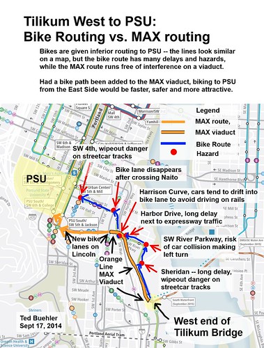
But as reader Ted Buehler argued in a series of comments this week below our story about the apparent decline of biking among PSU students, Tilikum Crossing was so close to being so much better.
The Tilikum Bridge isn’t going to help all that much, because Tilikum to PSU will still be crap. Whereas MAX has a long flyover from the west end of the Tilikum Bridge to SW 4th and Lincoln.
If they had funded a mixed use path on the MAX bridge, you’d be able to go straight from OMSI to here: http://goo.gl/maps/LLiVp without playing fender tag with cars on surface streets.
As it is, the day the bridge opens, bicyclists will need to ride on a half mile of congested bikeways, streetcar track interactions, traffic signals, and cars infringing in the bike lane because drivers tend to keep their wheels off the rails.
Moody and Sheridan. A long wait at a traffic signal, followed by a double checkmate hazard — if you swing wide enough not to have your wheel eaten by the streetcar tracks, your wheel will slide out on the storm sewer grate.
Moody and SW River Pkwy. I’m not sure how you’re supposed to make a legal left turn here. I guess you just play fender tag, and hoe you don’t get rear-ended by inattentive drivers going straight.
SW River Pkwy and Harbor Drive. Where you have the pleasure of waiting at an extremely long traffic light for our favorite 1950s expressway, Harbor Drive. That overhead bridge is where MAX goes — the direct link from Tilikum to PSU. That’s where bikes would be riding if they hadn’t put bike infrastructure on a starvation budget.
SW Harrison, on the hill. Where minivans encroach on the bike lane on a steep hill (where bicyclists require the most space because they wobble more). Again, that’s our friends the First Class Citizens on MAX overhead.
SW Harrison at Naito. Where the bike lane ends.
SW Harrison and 4th. Where you need to navigate a double set of streetcar tracks at a noncompliant, dangerous shallow angle.
My point? PSU needs direct bicycle access from the east side. The Tilikum Bridge won’t connect bicyclists from SW Moody to PSU. Bicyclists will need to ride through 6 dangerous, slow, or unpleasant intersections.
If, however, a bikeway had been included in a half-mile section of the Orange Line right of way, the connection would be smooth as glass.
Update 3:30 pm: In the comments below, reader Esther says a path that has yet to open will help riders skirt some, though not all, of these problems.
Advertisement
A follow-up comment from Buehler (whose academic research, before he moved to Portland, focused on the factors that caused the plateau and decline of biking in Davis, California):
I was down at the Tilikum west bridgehead tonight. 11:00 pm. 2 bicyclists went up the MAX viaduct to get to PSU. Classic.
I was going to take my riding mates on the Hellhole of a route from the Tilikum to PSU, via Moody, SW River Pkwy & SW Harrison. Instead, Rev Phil looked up the MAX/bus ramp and said “why don’t we just take this.”
So I rode the MAX viaduct myself, with 3 friends. It was sweet. So direct, so clean, sailed above Harrison and Harbor Drive, under I-5, it dumped us out onto a fabulous, brand-spankin new set of bike lanes on SW Lincoln at Naito. Infinitely better than the nonexistent westbound bike lane at SW Harrison and Naito.
I suspect that after the Tilikum opens that there will be a surge of bicyclists taking the viaduct downhill to get from PSU to SE Portland. They’ll have to put up signs with fines for any non First Class Transportation Mode folks from using the bridge. And enforce it. Because it’s a Grade A Platinum Route from PSU to SE Portland. But not open to bikes.
I doubt they’ll get the funding to add a multiuse path to the viaduct anytime in the next 40 years. So biking from SE to PSU will still suck rocks.
So close, but so far.
#bikeinfrastructurestarvation
And finally:
I was leading a ride of 4 people, and I wanted to ride the Tilikum => PSU Bike Route myself, just to demonstrate for myself that it really was a Hellhole of a route (I’ve ridden parts of it (some with BikePortland writer Michael Andersen), but not all of it. And after writing a treatise about it on BikePortland I figured I ought to go out and make sure it was every bit as bad as I said it was). Riding at 11:00 PM, because that’s when I was there, and because you can stand around and inspect the infrastructure at that hour without getting mowed down by cars.
So I was there at the west bridgehead, with Rev Phil and two lesser known riders, explaining to them that “This” waving my hand up the smooth concrete ramp with MAX tracks “is the MAX route from here to PSU.” And “That” (waving my hands up Moody) is the Hellhole of a bike route, which we’ll ride.”
And, along came a dude on a bike. Looked like a stereotypical PSU student. Coming up from South Waterfront on the Moody Cycletrack. And, what did he do? He hooked a left on the MAX viaduct and busted on up to PSU that way. Just like he’d been doing it every day of his life.
Then another bicyclist came along and asked us if that was the way to PSU, and we said “yup, that’s the way.” Up the viaduct he went.
And at that point Rev Phil made the rather astute observation that instead of just describing how nice of a ride the viaduct would be, that we could just field-check it ourselves. And we did.
And it was sweet.
Sorry to go a little off topic, but these are the issues that PSU, PBOT and bicycle advocates will need to address if they want to increase student bike mode share to campus. Can you ride a bike there easily, quickly and safely? If there’s an opportunity to do it, and it’s not done to cut a construction budget to the bone, then you’re failing in your objectives and failing to your constituents.
I recommend that ya’all get out there and try riding the MAX viaduct from Tilikum West to PSU sometime in the next couple months. Just to experience what excellent bicycle infrastructure could be. So you know what to ask for in all future public meetings.
Do it before they take down the construction fences and put up a sign that says “Max fine $1399 for trespassing on this bridge.”
Note to our friends at TriMet: Buehler’s recommendation, not ours.


Thanks for reading.
BikePortland has served this community with independent community journalism since 2005. We rely on subscriptions from readers like you to survive. Your financial support is vital in keeping this valuable resource alive and well.
Please subscribe today to strengthen and expand our work.
Hoe embarrassing!
blame it on autocorrect.
Regarding the first 2 “hazard” points. 100’s of people take this route daily currently and it doesn’t seem to have that many problems. Could it be better? Sure, but it’s not that bad (especially the light at Moody/River where most cars are also going left and you can either take the lane or go straight or left from the bike lane).
I totally agree with you. However, for whatever reason I thought there was going to be ped/bike access on the viaduct, and seeing the headline my jaw dropped a little since access should have been a no-brainer to the Tri-Met folks. It’s pretty ridiculous this was not part of the plan.
My evil twin brother is going to be riding this all the time. He doesn’t like rules.
Yup. I didn’t even realize that, either. What a no-brainer. UGGH
I’m going to guess it had something to do with safety? Like rail safety (same way the MAX cars are swept for bombs at the airport).
Yeah, like all those cars and trucks driving along and across the Max tracks on Interstate couldn’t possibly pose any threat,… But yeah, those crazy terrorists on bicycles need to be kept away from the tracks.. doh
Doesn’t that saying go “The revolution will not be motorized”?
I’m just trying to come up with SOME kind of reason.
Tri-Met has a history of failing to accommodate bike/ped in MAX projects. Look at the Green Line and the I-205 bike path. How hard would it have been to put a path on the side of the new bridge over Johnson Creek? Instead, cyclists have to make a challenging (to newbies) diagonal crossing of SE 92nd Avenue. In other locations, a path could have been built on the MAX flyovers to get across other major roads.
Only recently have they (occasionally) started to get better about this, like the recent path placed under Division within the Green Line right-of-way. A path which, honestly, should have been planned AT THE PROJECT START.
Tri-Met needs to step up their game. BTA needs to hold Tri-Met’s feet to the fire. The local community needs to start complaining more vociferously, and we need to have some of the same grass-roots events we had in 2006 and 2007. Change won’t happen until there is pressure at multiple levels. We also need advocates in the civic realm: Mayor, city council, county commissioners, transit commissioners, ODOT, and any other local, regional or state transportation board, committee, or stakeholder group. Sure, we have some. WE NEED MORE.
I take Barbur into downtown from SW PDX/Tigard, pretend I’m a car and take Naito to the Hawthorne Bridge. As construction started on Tillicum, it seemed like such a great way to avoid a few congested blocks of downtown, and I looked forward to a new, safer, faster way to get to work in SE. But as the connections on and off the westside of the bridge became apparent, it quickly became obvious that my old trusty route will be the mainstay. If they had put a multi-user path along the Max tracks, I would gladly take that up to 5th, then head home on Barbur, avoiding the abrupt end to anything bike-friendly after the Hawthorne (coming home from the eastside).
I couldn’t agree with Ted more. Such a simple thing to design into the connections.
Ooh, could we call this a “Missed Connection” and submit it to Craigslist’s Best-of?
I belieeeeve (someone at PBOT or PSU help me out here?) that points #1-3 are incorrect – there will be a new bike path connecting from SW Harbor Way (riverplace hotel) all the way along the max tracks until it connects with the existing bike path on Moody at Sheridan. So you 1. won’t have to cross Sheridan & Moody intersection diagonally (northbound), 2. won’t have a left turn at Moody and River Parkway in tandem with 3. will have a straight through, signalized crossing at River Parkway. You can see the existing path when you bike to the South waterfront from Riverplace.
correction, the first few blocks from Riverplace hotel are on street signed bikeway (on the existing street you can see on google maps), but where the street ends, the new bike path will pick up.
Yes, this is correct. I also thought it was supposed to be open by now, or very soon. PSU has classes starting up in a week and is telling people that’s how to get down there.
PBOT has told us this trail segment will be open next week, just prior to classes starting at PSU. Thanks for pointing this out, Esther!
The train/bus only viaduct from Naito to Moody will be called SW HARBOR VIADUCT. The multiuse trail under that will be called HARBOR PATH.
I agree the Harrison route is shite tho. 🙂
You are correct. There is also a multi use path on the east side of Naito to connect the new bike lanes on Lincoln to the existing ones on the Harrison connector. Points 5 and 6 therefore are less relevant than they seem at first.
There’s a decent point about the fact that the Harbor structure could have had bike/ped access, but I think the author is exaggerating how bad the alternatives are for the purpose of making his case.
It’s not perfect, but I would point out that there’s an MUP from Sheridan/Moody to Harbor Drive/River parkway so you can avoid a lot of the streetcar track mess at the moody/river intersection. At least there is supposed to be, I don’t actually know if it is open yet I haven’t been down there in a while.
I wish I knew where it was, but I know I’ve seen an official answer/excuse for why there wasn’t a path on the viaduct. My suspicion is that it is too steep to be able to legally do it without a lot of loop backs.
In general it is hard to accuse the Orange Line process of not considering bikes and keep a straight face though. The whole project has contributed almost as much high quality bike infrastructure to the area as every other bike project combined for the past five years or so. I’m not saying there couldn’t have been more, but it’s a pretty solid step in the right direction.
Thanks to you & Esther, I now know about this path (although I think it’s still closed from Sheridan to the Harbor/River Pkwy intersection.)
I’ll let my evil twin know, since he just uses my ID and I don’t want to get his ticket.
As of today It is still not open yet. This is despite it being quite rideable for the past 6+ months. Can’t tell you how I know that.
Until then, to make a safe left turn from Moody onto River Parkway just enter the main lane (making sure it is safe to do so) and make the left turn from the right lane (it’s allowed there.) I do it every day.
PBOT’s Roger “Geller said it would have been a complex engineering task and an additional $5 million ‘we didn’t have’ to include a bikeway on the bridge.”
http://bikeportland.org/2014/04/11/exploring-good-bad-ugly-and-new-bikeways-with-pbots-bicycle-advisory-committee-104397
Booooooooo.
Was a bike path on the MAX “viaduct” proposed and pushed during the planning stage?
Speaking for PSU, yes, the addition of a bike & ped facility on the viaduct was proposed and pushed during the planning stages. Ultimately, TriMet and PBOT determined this was not feasible.
as Ted said, we might have this awkward access from PSU to the new bridge for 40 years, all for want of $5 million… tough times.
Wow, I could have sworn I saw a bike path at the stop light before going on to the viaduct! Have my eyes deceived me this past year? Maybe I assumed they would extend the path and saved the green paint for later. I guess the green paint will never touch the viaduct.
I think that’s why I thought there was access to the viaduct (Harbor structure.) But in my consultation with Google Maps the bike lanes continue down to Naito past First on the part of Lincoln that is still closed to auto traffic.
How can this post go up without reference to this easily obtained map that details the new bike route?
http://trimet.org/pdfs/pm/BikePed_Maps/Lincoln_SWaterfront_BikePed_Improvements_With_Copy.pdf
Thanks for providing the link, but what webpage on Tri-Met’s website provides a link to this? I couldn’t, and still can’t, find one; not that I need it anymore (although this is a draft, so maybe I will.)
http://trimet.org/pm/abouttheproject/index.htm
There is an existing alternative route that is faster and easier than the route stated:
turn onto Sheridan from Moody briefly then to Water Avenue’s end, short walk up the steps or bike on the grass, up to the Lincoln bike lanes and you’re there at PSU. No Streetcar or major auto hazards and has signalized crossings… Alternatively you can go up the steeper Caruthers then under Naito on the paved sidewalk or up the gravel/stairs to the bike lane.
With very minimal (and cheaper) improvements the new multi-use path (which is neglected in the post by the author to make his argument stronger) under the viaduct could continue past the Harbor Drive intersection, near the Grant ROW, gently curving up to the Naito/ Lincoln intersection.
The “missed opportunity” of a Harbor Structure add-on would have cost an exorbitant amount of money (seriously) for a transit project that already had to shave tens of millions while still maintaining the biggest boost of bicycle improvements Portland has ever seen, whereas paving the missing link up the Harbor Drive-to-Naito hill would be far, far cheaper and almost as nice.
Also, breaking the law should not be encouraged, regardless if it’s ‘safe’ right now, if bicycling ever wants to garner respect from other “First Class Transportation Mode folks” (as the author so justifies with his own prejudices).
“With very minimal (and cheaper) improvements the new multi-use path (which is neglected in the post by the author to make his argument stronger) under the viaduct could continue past the Harbor Drive intersection, near the Grant ROW, gently curving up to the Naito/ Lincoln intersection.”
It could be. But it hasn’t been done. And I don’t see any evidence that this path will be paved any time soon
Good route…thanks!
Perhaps someone at PBOT or BTA could sketch up a detailed map of this area. The existing SW Portland bike map doesn’t have the smaller scale that would allow for easy route finding in this area, and the prevalence of overpasses over overpasses in this area makes Google Maps had to read what is happening on the ground.
During Pedalpalooza I led a ride about this poor connection, as well as potential improvements to the Park Blocks, and a future route from the Park Blocks over the Broadway bridge: the Green Loop route:
http://www.facebook.com/events/658107217598200/
Somewhere on BikePortland I expressed concern about the lack of connections for cyclists at the west end of this bridge at least several years ago.
Man, I wish we’d been able to follow up on that. Thanks for trying, Buzz. But it’s a good reminder that though lots of folks with some influence do read the site (and some read the comments) commenting here is usually less effective in getting direct change than emailing someone at the staff level. Unfortunately.
The best way to use a BP comments thread, I think, is to throw your ideas to the lions! I am constantly in awe of the intelligence and information of BikePortlanders. This crowd is great at honing, debunking and building on ideas.
“I am constantly in awe of the intelligence and information of BikePortlanders”</i?
True
I will reiterate that IMO the even larger missed opportunity was to include a bike/ped fecility on the streetcar viaduct from MLK to OMSI. The alternate route is in way safe or direct. This would have connected inner SE neighborhoods to the waterfront in such a great and safe way!
I use a variation of the route ND recommends. From where Water Avenue ends just past The International School, ride on the short cut through to Harrison Street and turn _left_ onto the sidewalk. Ride a short ways up the sidewalk to the Streetcar station and use its zebra crosswalk to cross Harrison over to the bike lane. From there take Harrison up the steep hill to PSU. I take the full right lane going up Harrison, and the recent addition of sharrows has helped with impatient drivers behind me. I plan to continue using Water Avenue even when that still-closed bike path opens, as my route takes you under Harbor Drive rather than across it.
Yes, I have been thinking about this for years. The part people are missing is that Tillikum crossing is going to be *the* bridge for those of us who are normally served by the Ross Island Bridge (by car) — i.e. people living along Division, Powell, Holgate, Woodstock, Sellwood, Moreland, Milwaukie, Foster, etc. That’s the vast majority of SE Portland, when you think about it. This swath of Portland is currently biking over the Hawthorne bridge.
Tillikum will be great for getting to OHSU, but of course most people really just want to get downtown or to PSU — so those of us in SE will still be stuck without a great option (die on the ross island, bike to SoWa over Tillikum, or go out of the way to Hawthorne).
This was a huge missed opportunity.
While I agree with you. Isn’t the Hawthorne still mostly on the way if you’re going to most of downtown (esp. the central and Northern parts) ? The new bridge will only be really more convenient (minus the hopefully better lane/path) if you’re going to more Sourthernly locations in downtown like PSU or OHSU.
I have two thoughts here.
First, the “lost opportunity” would merely have provided an alternative to what is already a short and easy ride down Moody and Riverfront. That is maybe a five minute ride, much of it on an elevated MUP.
I understand we want to broaden cycling to the so-called “interested but concerned”, but if someone is too “concerned” to ride Moody to Riverfront to Naito today, I question if anything will make them get off their duff (or car seat) and become a bike commuter.
Second, admittedly the remainder of the route to PSU isn’t as low-stress, after you get out of South Waterfront and into downtown, so improvements are needed there – which is past where a viaduct MUP would have ended.
But instead of a bike path on the Max viaduct that is freeway-like – great for getting from point A (Tillikum) to point B (PSU) but not anywhere in between – perhaps it is better to upgrade and add to the network of local surface-street bike routes?
It looks like there will be significant improvements with a couple of new MUPs, new bike lanes on SW Lincoln and connecting streets, lots of new crossings. Which will benefit people riding to and from many places in South Waterfront and downtown, not just people riding to and from PSU.
I don’t know what a bike/ped path on the viaduct would have cost. If it had been included, would any of those surface street improvements have been funded?
Take the lane!
My 6-year-old son and I rode from our house in SW to destinations on the eastside this weekend. We ride this way every morning to school, but he always rides the tagalong, not his own bike (as he did this weekend). On our second homebound trip yesterday he didn’t want to ride (again) up through Riverview Cemetery, which is a pretty steep haul even for grownups. We wanted to take Terwilliger, which would be a nice gentle grade with low traffic.
But there was absolutely no safe route from Hawthorne Bridge to Broadway for a six year old. Nada. You can’t even ride your bike (legally) on the sidewalk downtown. So we were back down the westside greenway to the cemetery for the 3rd time in 2 days…
If you can imagine some way for a six-year-old to ride from the waterfront — to PSU, I am all ears, because it would be AWESOME.
Being able to ride on the Trimet grade would open up huge possibilities for riders like my son — who has no problem riding 20mi with 1000′ of elevation but is just too small and slow to take the lane downtown.
South Waterfront –> Gibbs St. bridge –> Neighborhood streets –> cross Barbur at the light at Hooker st. –> sidewalk to Duniway Park paths to Terwiliger?
Admittedly, doesn’t go through downtown proper, which is actual a significant destination for kids, between daycares, festivals at Pioneer Courthouse Square, the Central Library, etc.
Yup, we’ve done that. Also the route improvements above will probably make it OK for my 6.y.o.
Any reflection/update on the bike route that will be implemented voiding many of the points made above? Prior to publishing this was there any contact made with Trimet to verify accuracy?
http://trimet.org/pdfs/pm/BikePed_Maps/Lincoln_SWaterfront_BikePed_Improvements_With_Copy.pdf
My understanding is TriMet is working on an updated map.
I think making downtown suitable for six year olds to ride alone is a idyllic vision but unrealistic at this point and at the current level of budget and political/public support. And if we did, how many six year olds would then regularly do so? I’d be shocked if it was more than fifty per day.
There is so much to be done to make routes in/out of downtown suitable for adults and teens on bikes. And routes elsewhere in the city – East, SW, etc. I’d rather spend the money to achieve that level of bike-ability in the city. Because that is a goal we could actually achieve in my lifetime.
There’s a saying about not letting perfect be the enemy of good.
I was going to say the same thing. Well said.
Yeah you’re right. Can’t win, don’t try. Let’s continue to tweak the routes leading into downtown, and then dump those routes into the Thunderdome. Take the lane, weakling! Especially since this could be as expensive as fresh paint and signage ala the Broadway cycletrack. Such profligacy!
I’m sure streets that benefit 6 year olds couldn’t possible help people with balance difficulties or other disabilities, the elderly, tourists on rentals, cargo haulers…or just anyone a little more timid than us battle-hardened road warriors.
The MUP underneath the viaduct is open as of yesterday. That said, many of the bicyclists I saw were still using SW Moody.
Hi All,
I’ve been bike touring in the Cascades since Friday, missed the whole discussion.
I’ll read in detail and post comments in a day or two.
Ted Buehler