It’s always interesting to look back and see how bicycling has grown in Portland over the decades.
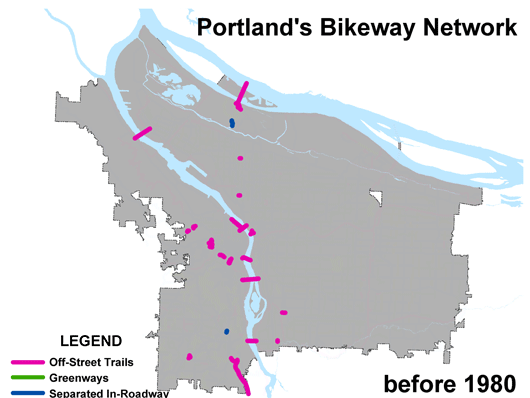
Back in October 2005 I took some slides from a presentation by PBOT Bicycle Coordinator Roger Geller and put together a GIF showing the development of Portland’s bicycle infrastructure each year from 1980 to 2012 and beyond. That one’s worth another look:
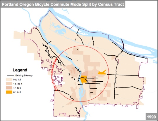
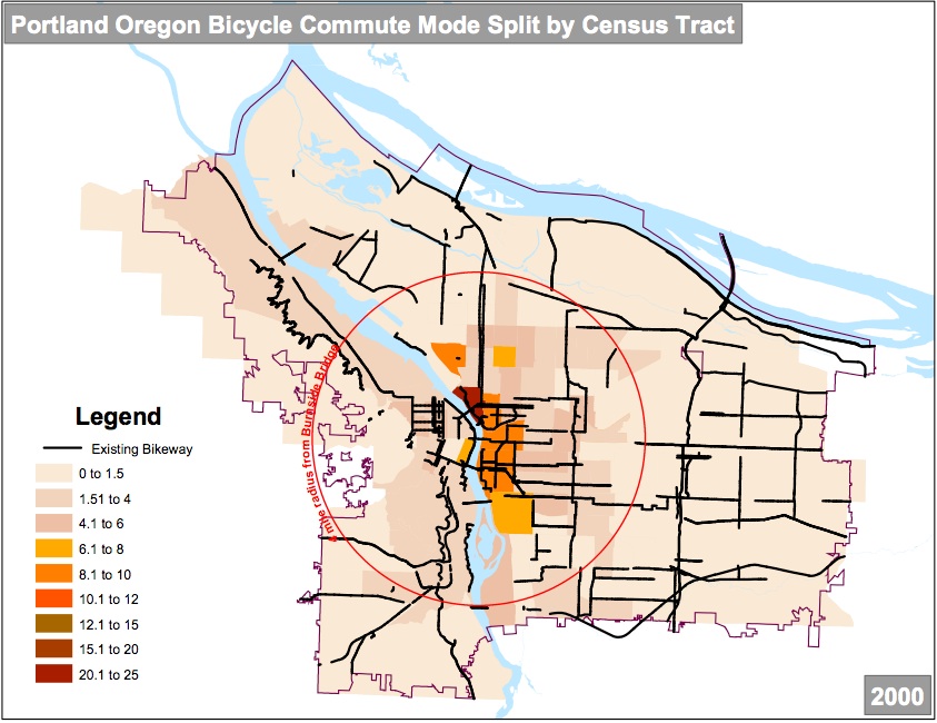
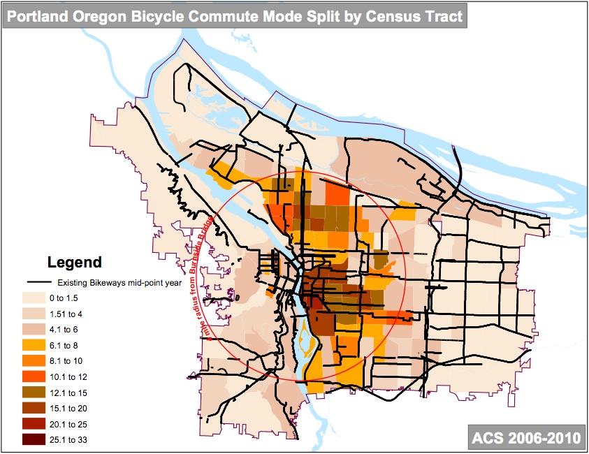
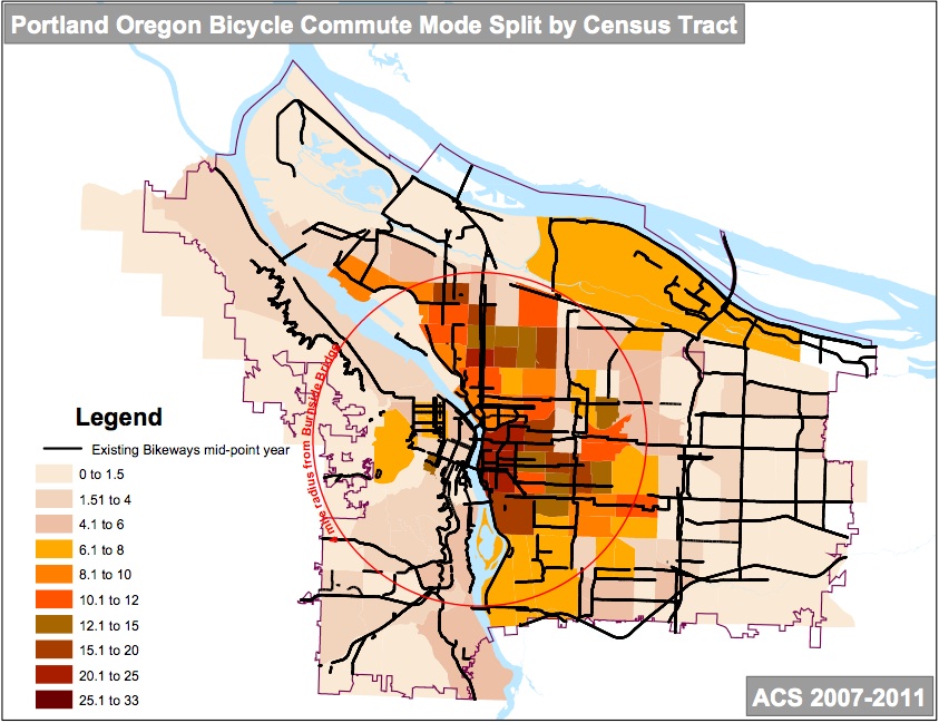
The GIF above is neat, but it only shows infrastructure. Now I’ve put together a more up-to-date animation that combines infrastructure with bike mode share. In the 2012 Bicycle Count Report released by PBOT this morning, Geller included several graphics of the bikeway network overlayed with U.S. Census tract data based around a four-mile radius of the Burnside Bridge. When those graphics are put together into a GIF, you see a more compelling visual picture of how cycling has grown in Portland between 1990 and 2011:

GIF by BikePortland using graphics created by PBOT
While it’s fun and reassuring to see our progress over time — in both system development and ridership numbers — we are growing at a slower rate. There are many people in Portland still waiting for us to complete our network of bike-friendly streets. And until we do, we won’t see a huge jump in ridership. Stay tuned.
UPDATE: If that GIF goes too fast to fully comprehend each graphic, I’ve shared them below for your viewing pleasure (click to enlarge):


Thanks for reading.
BikePortland has served this community with independent community journalism since 2005. We rely on subscriptions from readers like you to survive. Your financial support is vital in keeping this valuable resource alive and well.
Please subscribe today to strengthen and expand our work.
+1 across the board… looking forward to more!
Whoops, double posting… hit enter early.
Curious, how and where are you getting the statistics for mode share? Correct me if I’m wrong, but that’s 25.1-33% mode share close into the core there right? I’m going to (unless it isn’t ok) a blog post and use those images you’ve presented here to add an elaborate some of the holistic advancements that have been made related to an increase bicycle mode share.
Cheers!
Interesting how the neighborhoods north of Lombard are so pale compared to their neighbors just to the south of Lombard. Is Lombard acting as a massive bike commuting barrier?
It’s all uphill from Kenton to Killingsworth. From the heart of Arbor Lodge it’s all downhill into town.
And 82nd. As mode share continues to grow, the inner/mid city “box” is gonna be really obvious.
I moved out just past 82nd just this winter. Before that I had been pretty blind to this area of town. (Prior to that living in inner SE/NE and working in inner NE with excellent bike facilities. Even when I lived in N. Portland I had bike lanes all the way to my work)
Now, every day when I ride to work, it’s a sometimes frightening, almost 10 minute wait to cross 82nd while waiting for traffic at the corner (at a school no less!) with no crossing markings for several blocks in either direction. I would have to take the sidewalk, which I don’t feel I should have to do on a bicycle. I am part of traffic. I rarely ever put my bike on the sidewalk unless I am locking it up.
I hate to use the ever so scholarly “the infrastructure sucks” out here. . . but, a couple blocks behind my place, there is a street with absolutely no shoulder (and a “someone got hit here” tribute) cars whipping around the curves at high speeds – I’d go to the fred meyer on glisan/60th instead of the closer one on 102nd because there’s just no safe way to get to it with the overpass and everything. It’s an absolute spaghetti-mess over here. Completely discouraging. Plus, there’s not convenient shopping like there is inner Portland. It’s not made to easily get to. Wide streets. Fast speeds. Not user friendly. It’s made for cars. Not even really bus friendly.
Is there a way to just see the original images separately? The GIF scrolls through way too quickly to process at all.
Of course michael. Just added to the post.. click to enlarge..
Where do they do counts in NW? I commute every day down Raleigh/Overton and then on Naito (and I encounter lots of folks doing the same thing), but have never seen the clipboard folks out counting until I get to Waterfront Park. Perhaps the decrease in NW is low because they missed one of the major corridors?
CPAC, you can see the count locations in the report tables. See the report here: http://www.portlandoregon.gov/transportation/article/448401
Still waiting for the East Bank extension from Steel Bridge to St. Johns Bridge. ^^^Sigh^^^^ of exasperation. Give us back our river and its banks.
It’s sooooo nIce to see soooooo much going to the first 2 mile circle from downtown (with little to no effect on Downtown cycle traffic). Can we please get some love in the rest of the city.
Thanks for giving a graphic that clearly shows how lopsided the funding has been for all the cities bicycle improvements. Though I know it wasn’t your intent, clearly all the focus has been a very small segment of the city.
Come on hardly any change at all East of 39th since 2005 (even worse past 205) and the West side isn’t any better either.
Yeah Lloyd, Irvington, and Buckman, you’ve come a long way. I’m sure all the tourists love it, Too bad it’s all at the expense of the rest of the city and for the people that live here.
Just to be clear: the commute mode split data is shown for all census tracts in the city. The 4-mile radius circle centered on the Burnside Bridge is there for reference, only. It is not surprising that the highest commute activity is closest to the Central City. That pattern is seen in bicycle-friendly cities around the world.
This comment is a response to the following text in the article: “Geller included several graphics of the bikeway overlayed with U.S. Census tract data based around a four-mile radius of the Burnside Bridge.”