that will be posted at
entrance to Waud Bluff Trail.
Next Tuesday, officials from the City of Portland Parks and Recreation bureau will join community leaders at a groundbreaking ceremony for the Waud Bluff Trail; a short, paved path that will connect North Portland and Swan Island near the University of Portland.
After six years of waiting, Swan Island businesses, trail advocates, and thousands of residents eager for safer and more direct access to the Willamette River have rejoiced at seeing this project move forward.
Unfortunately, for people riding bikes (and others using wheeled modes of transport), the trail will present several challenges.
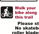
For starters, the trail will be very steep. According to Portland Parks and Recreation (PP&R) landscape architect and and trail planner George Lozovoy, the upper section of the trail (off of N. Willamette Blvd near University of Portland) will have a 10-13% slope. It’s steep enough, says Lozovoy, that PP&R will advise people on bicycles to walk their bikes.
The warning sign below will be placed at the Willamette Blvd. entrance:
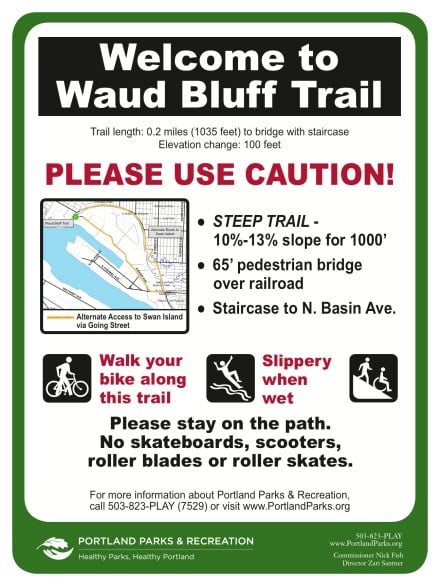
For comparison, the ramps leading up to Peace Park and the Rose Quarter Transit Center from the Eastbank Esplanade are at a slope of about 5% or less. Making the Waud Bluff even trickier for bikes — and for a mix of people biking, walking, and rolling in wheelchairs — is that it will be only 10 feet wide. (According to the AASHTO guide, 10 feet is the minimum recommended width for a shared-use path.)
In fact, it doesn’t even look like the upper section will be ADA compliant.
According to AASHTO, “In general, running grades on shared-use paths should not exceed 5 percent and the most gradual slope possible should be used at all times.” The Waud Bluff Trail is at least a 10% grade the entire 1,000 feet of the upper portion. Plan drawings show that landings/rest areas have been placed every 200 feet; but AASHTO guidelines clearly state that a 10% grade should only be maintained for a maximum of 30 feet.
After the 1,000 foot long sloping upper section, trail users will come to a new bridge that will take them over the Union Pacific Railroad tracks. On the other side of the bridge, people on bikes will face another challenge: about 45 stairs that descend 25 feet to the lower section of the path.
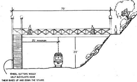
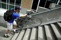
People with bike trailers and large cargo bikes will have a tough time getting down. To help path users with more easily manageable bikes, PP&R will install 10-inch wide wheel gutters along the walls on both sides of the staircase (similar to ones found in Southwest Portland and at the Hollywood Transit Center (in photos below).

Hollywood Transit Center.
(Photos © J. Maus)
A narrow path, a long stairway, and steep grades all add up to what will be limited access for wheeled travel modes.
The problems (as you might have guessed) go back to an alleged lack of funding. The total cost of the project is just over $3.2 million (using a mix of federal, state, and regional funds), which isn’t enough for a wider trail, ramps instead of stairs, and a longer upper section (that would have been necessary to decrease its slope).
Lozovoy said that a “project prospectus” drawn up by Alta Planning + Design in 2005 included a staircase. That document set the funding outlook in place, which Lozovoy says “was the first nail in the coffin for not getting a ramp” instead. Underfunding also lead to the 10-foot width — instead of the 12-foot wide path — Lozovoy said he would have preferred.
Some stakeholders are pleased that the trail will be so steep. According to a PP&R press release, the U.S. Coast Guard station on Swan Island plans to use the steep trail for physical training.
And, even with limited bike access, local advocates — especially supporters of the North Portland Willamette Greenway Trail — are pleased to see any new path construction at all.
— For more on this project, see the City’s website.


Thanks for reading.
BikePortland has served this community with independent community journalism since 2005. We rely on subscriptions from readers like you to survive. Your financial support is vital in keeping this valuable resource alive and well.
Please subscribe today to strengthen and expand our work.
EPIC ADA FAIL
*** Paul, I hear your sentiment and I’ll let this comment stand. But please consider how using all caps and leaving a comment like this impacts the general trajectory of how other readers feel about all the subsequent comments. Thanks for understanding and for trying to leave more thoughtful comments in the future. — Jonathan **
I still like the idea of bringing back the thumbs down button so the community can steer the conversation a bit more; that may have allowed for a more hands-free correction.
At that grade and with stairs, I think wheelchairs are written out of the plan altogether.
The bridge still seems like an expensive, imperfect solution. The safety and standards issues are moot—there’s already an ad hoc path—and I don’t see how grading and paving another 500 feet of trail to make for a level crossing costs more now, to say nothing of future maintenance.
* already a ad hoc shortcut path, so you can just bypass the bridge
they should have waited for more money to build a path usable to more than just pedestrians… they wasted the money building something non-standard and non-multi-modal… are they even allowed to do that? they’ll have to tear it out if they want to do it right…
We should have built an at-grade crossing of the railroad, or built a ramp instead of a staircase. The current plans have ZERO access for wheelchairs (in addition to making it hard to access by bike).
Thanks for the thorough run down on Waud Bluff Trail.
BTW, the plans have been out there for years now, and yes, they are not all one could hope for. But for employees of UPS (2000), the US Coast Guard, Western Star Truck Plant (soon to be 1000) and other employers at the north end of Swan Island it will be a big improvement over the existing “made path” up the old service road with its open rail crossing, steep muddy sections, & poison oak.
Still not happy? Get involved in the Parks Department’s North Portland Willamette Greenway alignment project and advocate for a ramp in addition to the stairs up to the bridge as part of the WGT. Join npGreenway!
Why a bridge? When Alta Principal George Hudson and I were out there in 2004 (Jesus, 8 years ago!), the first thing he said was you have to do a bridge. UPRR OK’d the idea without delay; an at grade crossing was a non-starter for both the RR and ODOT which manages railroad crossings.
Not ADA? Yes, we knew that out of the gate due to the grade of the existing path. The cost of cutting an entirely new grade would have killed this thing on day one. The City’s ADA advisory commitee gave the project the green light due to its use of the existing grade. That meant that stairs would be OK as well, and frankly, when we started to go for funding for this project bike’s with trailers were not on my radar…there just were not so many 8 years ago.
Lenny Anderson, Exe. Dir., Swan Island Bus. Assoc.
Thanks Lenny for bringing some facts & common sense to the party. Not as exciting as the rants we’ve come to expect here, but prolly a better deal long term.
Yes, this is a situation where the physical restrictions of the space just do not allow for an ideal solution for everyone, but a workable solution for the vast majority of people. Thanks for putting some perspective into the conversation. Since there soon will be a good connected way to Swan Island (Going to the River) it seems that the purpose of this trail is primarily for the people who use it most for work purposes, rather than recreational use. This makes complete sense, and it still seems that it will accommodate bikes fine – just not people who want to ride every moment of their trip. Obviously the stairs make it non-ADA compliant, but in some ways it is probably safer for wheelchair folks to have that expectation up front and take another route, rather than thinking they can make it and then crashing out of control due to the steep grade.
That said, I agree that those “wheel gutters” are fairly useless. It is easier to just carry your bike up and down stairs, or lead it with just the back wheel touching the stairs. Or freeride them…
Thanks Lenny (and Patty below) for giving us more history and background rationale on the details of this project than Maus was able or willing to report. My understanding had been enhanced by your synopsis of this long process.
Yes the plans have been in place for quite a while and the trade-offs have been documented. I was disappointed to see BikePortland take such a cheap shot.
David,
Please explain to me how this is a “cheap shot.”
I’m pointing out more information on something I myself didn’t realize until looking into this story… That bikes will have a tough time using this new path due to its extreme slope and presence of a large stairway.
Does this trail offer only limited bike access? yes.
Have details about this limited bike access (the stairs and the slope) been covered yet? no
Am I personally disappointed that we’re spending over $3 million on a non-motorized path that doesn’t fully accomodate bicycles? yes.
Is anything better than nothing? yeah, I guess.
8 paragraphs of digging and picking how it is bad and 3 short paragraphs of marginal acceptance. Having a bad day??
Trails on steeper ground with limited room to work simply can’t be designed to meet every want.
This is why Parks & Rec don’t belong in transportation issues, motorized or not.
Are we asking too much in this location? It would be like getting an ADA facility up through Washington park. The terrain is just too steep.
At last, some decent mountain biking within city limits.
Sometime a less than ideal solution that happens is better than a perfect solution that doesn’t.
As a frequent user of the Hollywood Transit Center….those gutters do NOT work. They’re too close to the wall- my pedal drags along the wall if I try to use them. I hope that the various committees involved in this project find another solution or at least place the gutters farther from the wall.
I’m curious as to why a ramp-also like the one at Hollywood Transit Center, which provides alternate access for people who can’t use the stairs-isn’t practicable here. No, the HTC ramp is NOT really usable for bikes unless you walk your bike, but ensures access for people using assistive technology.
The gutters at Hollywood don’t make much sense anyway, given there’s a ramp right there.
And an overpass a two blocks to the south. Much faster than going up and over the stairs at the TC.
Some background on this project, as I did some early scoping:
ADA is silent on outdoor facilities unless they connect parking lots to buildings. There is physically no way to make this trail even legal ramp grade, 8.3%. It would mean clear-cutting the entire hillside and re-building the entire slope – very steep, and hugely expensive. And railroads are not obligated to offer at-grade crossings. Look into railroad law. It’s arcane and written to give railroads the ultimate power and freedom. After all, they civilized the western frontier. So the bottom line: You can get from here to there relatively safely and without losing all the native Oaks. Ranting and accusing without information is not pretty.
How many disabled folks are using this trail anyway? Honestly, i’d love to know.
Seems like a chicken or egg problem; disabled people physically can’t really make use of a facility that isn’t accessible if they’re in a wheelchair.
A ramp would have required property acquisition either from the Union Pacific Railroad or National Guard. Both were not open to discussing this so a ramp, let alone the funding for a ramp, was never in the cards. The steep grade of the old road was was it was; changing it would also have been cost prohibitive given the instability of the upper slope.
Lots of excitement from the running and able-bodied walkers of our community. Hope we can see the good in having the connection even if not perfect from all standpoints.
Agreed that the Hollywood wheel gutters aren’t great. There are better designs available now. They need to be installed not too close to the edge.
The more facilities we have like this, the fewer people that will need ADA access. It pains me to see obese people with scooters that would otherwise be normally mobile members of society.
Mia, Lenny, Patty, and others… Thanks for your insights about this project. I had a feeling just getting this story out would spur some good information sharing.
I think that they should look for aditional funding and put in an elevator like in Oregon city. Perhaps Daimler?
Exactly. I’m sure there are a number of disabled people that work down on Swan Island, but somehow I would guess they do not want to roll several miles through North Portland, down the hill and then around the island to get to work. I’m sure there are exceptions, but in general I don’t see how ADA compliancy is an issue on “this” type of trail – where it would be ten times the cost (and never get done) if it were compliant.
Yes, it’s sad to see the trail is not ADA or bike compliant…but this is clearly the case where the choice is
a) A good trail for pedestrians, and only pedestrians
vs
b)No trail at all, so everyone can suffer equally.
I’m a huge ADA advocate, but in this case it would probably be cheaper to have an on-demand shuttle be made available for 20 years than make a suitable ramp.
Sounds like a fun climb to me.
Jonathan, my chief frustration here is that these plans have been out for years; we’ve had open houses in the neighborhood and Swan Island both. You’ve written stories on the deal. And frankly anyone with two good arms & two legs can handle a bike on this upgraded route; Swan Island employees already do it every day on the funky path we have.
The whole point here is to provide some options for folks who work on Swan Island and who do not want to drive to work alone in their cars (and gum up freight movement). The Waud Bluff Trail improves transit, bike and ped access to jobs on Swan Island. Period. If you live close by you can walk to UPS, US Coast Guard, or the Western Star Truck Plant or take the 44 Mock’s Crest bus and walk down, or bike in from where ever and take the new Trail… steepness and stairs notwithstanding…and continue to work. Waud Bluff Trail will be a much more direct route for many bike commuters than Willamette, Greeley and Going…none of which are particularly pleasant rides. Hey, if you live on Willamette Blvd. and work at the Truck Plant, it means three or maybe even four buses to get there! Soon it can be a safe, dry and pretty direct 10 minute walk.
Again, not satisfied? Get involved in the Willamette Greenway Trail Alignment project and join npGreenway and help us “get it right.” ADA to the River is a challenge everywhere. Going Street sidewalk which will soon be widened is too steep; the existing public streets north of U of P are way too steep. The only location where topography would allow ADA access to the River at Swan Island is via the “Dog Bowl” off Willamette Blvd, and that would require a substantial bridge over the UPRR mainline. Neither cheap nor easy. Can you do better? Then do it!
Thanks Lenny.
But to you and others. This isn’t about me not being satisfied. I am pointing out that we are spending over $3 million on a new paved connector path from NoPo to Swan Island and the path has limited access for bikes. That is all.
As news of the groundbreaking approached it occurred to me that — despite plans being available and a public process — that I hadn’t fully realized the nature of the bike access situation and I therefore assumed most of the public was not aware of it either.
With that in mind I published this story, pointing out the access limitations, details about the project, and a sliver of background as to why it came out as it did.
I absolutely think this is a great project and obviously it has many positive benefits for the community. That being said, I can’t help but think it’s a missed opportunity to do something even better. Hopefully if this project was starting today, planners would begin their assessment of its potential with quality bike access as a standard feature.
Thanks.
The cost raised my eyebrows; $16M per mile! That’s well into the range of urban freeway lane-miles ($3M to over $20M), including land acquisition. Does that $3.2M figure for the Waud Bluff Trail include purchasing the land?
Anyway, it still looks like a cool trail with a good purpose and I’m glad it was built.
Urban freeway lane miles cost more like $25 – $75 million ($100 million – $300 million per freeway mile). Even a small interchange is probably $50 million, for starters, and there is about one interchange per mile…
This project isn’t all that different than a lane of urban freeway — a 14′ wide swath cut through rugged terrain with one bridge. The route needs to be surveyed, engineered, the right of way cut, retaining walls built, the surface compacted and filled with a few layers of subsurface material, then pavement. Railings, guardrails, wayfinding signs, concrete poured for curbs. The bridge needs footings, pillars, decks, and railings. Its all pricey stuff.
Ted Buehler
Pricey stuff, indeed, which is exactly my point. Some biking advocates frequently cite how cheap bike infrastructure is compared to car roads. But take whatever index you want, I don’t think you’ll convince many Joe Citizens that $16M/mile is peanuts. Making a claim that numbers don’t support is a good way to lose an argument. Better (IMHO) to own up to reality and make the case that it’s a good investment for any number of additional reasons.
Again, I like what I’ve seen of the WBT and I expect it will be a long-term benefit for Portland. I’m not arguing against it but I feel that costs for public developments need to be justified in the public’s mind if we want to see further such projects.
Jonathan, I don’t think you were in the wrong in how you wrote this article. You pointed out truths about this project. But, it might have given readers a more complete picture if you had included a paragraph stating the current conditions. That would have given readers who are not familiar with this area of North Portland the opportunity to see how big an improvement this project will be, even if it conditions will still not be ideal even after the project is done.
I like a challenge. I’ll give it some thought.
http://www.ssqq.com/ARCHIVE/vinlin27a.htm
Lenny,
Regarding “ADA to the river” here’s a quote for you:
” Later a sandstone brick was put down when the ferry landing was put in at Alberta. They used to zigzag the horses back and forth across the steep hills near the Willamette River.”
http://www.volgagermans.net/portland/albina.html
I think the Waud Bluff crossing will work well for employees on Swan Island, but this is a public trail, connecting public streets for teh public. My point is, these stairs will not work for a lot of people who would otherwise use it. I accept the grades are prohibitive to get a fully compliant ADA trail, but a steep ramp and steep trail still offers fewer barriers. Consider families on bikes: A kid in a trailer, or a kid with their own bike could push up a steep ramp, but not stairs. I am happy to see some progress, but it feels like the focus on employees was simply too narrow and short-sighted, and I think this may fall a bit short.
That sign is incredibly entertaining. Hopefully it will be accompanied by a box of information pamphlets that you can take with you along the path.
“Next you’ll come to the third landing. This landing is 25′ in length and composed of concrete. If you look to your left, there is a tree. Continue along the path by putting your left foot in front of your right and then right foot in front of your left. Repeat this process until you reach the fourth landing.”
Seriously though, aside from the alternate route map, the sign seems to only state that which will be immediately obvious to anyone who uses the path.
This reminds me of New Seasons at the Rosa Parks MAX station. Everyone was excited when the project was announced, but when I saw the plans for a parking lot in front just like in the burbs I was bummed and thought “we can do better than that.”
Actually the Trail has some pretty cool habitat that’s worthy of an info sign or two. It passes thru Oak/Madrone forest which is common farther south in the Willamette Valley but rare up north except for south & west facing exposures that get more sun.
The understory has seen invasive removal as part of a BES fuel reduction project so native species are making a comeback. U of P has also done restoration on their portion of the Bluff. The habitat allows deer to migrate down from natural areas to the north as far as Madrona Park and the adidas campus on Greeley, its alive with birds, and no doubt there are a few coyotes hanging out. No wolves yet.
Bus 44, which stops right next to the entrance on N Willamette Blvd, terminates service around 10p to this area.
With the addition of this new path, are there plans to increase bus service on line 44 past 10p to this location/path?
JF, probably not going to see improved service on #44 at least in the near future. Which makes this trail so valuable, as Swan Island has very limited service in the evening, mostly around shift change @ 11 PM. I notice many bikes chained up at the top of the trail in the evenings.
Jonathan, I think aside from the width this solution probably IS the best available. I don’t know the story on the width, but I do know it would be expensive to build it wider than the existing trail grade.
So, not ADA compliant, supposed to walk bikes, no wheeled transportation beyond bikes as in scooters, skateboards, wheelchairs (it appears) etc. Among many other issues…
This is a failure IMO.
Way to cave in, and screw many along the way…
In 2005, when funding was announced for the Waud Bluff Trail (WBT), no one thought it would take six years and nearly two million dollars more than the $1.2 million initially granted. Tom Potter was Mayor, the economy was booming and the realistic expectation was it probably would take a year or two to line up everything to break ground.
Wrong.
While economic considerations and project delays predicated by higher priority projects forced changes, some things remain constant: Steep terrain, project realities relating to railroad and Governmental concerns, and still, the desire to connect thousands of Swan Island jobs to the rest of the community, while not forcing accessing the island through N Going Ave with its high volume traffic.
Finally, six years later, and an additional two million dollars in funding, the contracts have been awarded, and construction begins. The essence of the project remain constant, everything else has been in flux.
NpGreenway, working with the Swan Island Transportation Management Agency (SITMA) have worked in tandem advocating and encouraging the construction of the WBT. As an existing trail being improved, with recognition of the rail line at the base and the challenges it poses, we understood from the start that this would not be an ADA approved trail. The steep slope and the required crossing bridge would add much cost to the trail. At the same time, we realize this will ultimately be an important connection to the North Willamette Greenway Trail (NWGT) we too are advocating and working for.
Current users trek down an unimproved dirt and rock trail and risk crossing tracks often blocked by stopped trains. These many users value the existing trail, primitive and unsafe as it is, because it is the only other legal access to Swan Island besides N Going Street. SITMA has promoted the trail because it lowers motor traffic demands on an already strained roadway in one of Portland’s busiest industrial areas. Improved facilities, coupled with separated facilities already under construction in parts of the Island will encourage more bike and ped commuting, and will create a vital part of the NWGT.
We of npGreenway recognize this is not a perfect trail that will meet everyone’s needs. As the Trail Alignment Study currently in progress is completed and analyzed, it is likely that ways to include and improve the WBT to function with the NWGT are found.
In the meantime, npGreenway applauds its construction and looks forward to the Waud Bluff Trail to becoming a key connector to as our vision becomes reality
re bus service, the northern end of Swan Island is served by TriMet 85 all day, weekdays only and by the Swan Island Evening Shuttle weekdays til midnight. (We are looking forward to more riders to and from the new shift at the Western Star Truck Plant.) The transit “hole” is on weekends. USP runs Sunday thru Thursday; the US Navy/Marine base next to the US Coast Guard has weekend activities. The 72 Killingsworth goes only to Anchor Street on weekends; there is no 85 Swan Island service.
Day and Twilight shifts at UPS will be able to use the 44 on Sundays and walk down when the Waud Bluff Trail opens. Also, there is an 85 Swan Island stop w/ shelter in front of the USCG base at the bottom of the Trail; U of P staff and students will be able to walk down and get to the Rose Quarter TC in 15 minutes on a essentially express bus.
Question for Mia and Lenny —
Mia wrote
“A ramp would have required property acquisition either from the Union Pacific Railroad or National Guard.”
Would a ramp have been wider than the stairs and path?
From the site plan .pdf posted on BikePortland in September, the width of the stairs is the same width as the multi use path connecting the stairs to the street. (link http://bikeportland.org/2011/09/15/work-set-to-begin-on-long-awaited-waud-bluff-trail-to-swan-island-59076 )
I understand a ramp would be longer than the stairs, and if it was to be as narrow as the stairs it might need to be a bridge rather than a fill. So I see cost being an issue. But its certainly easier to ride or push a bicycle up a steep ramp than a steep set of stairs. Same for wheelchairs, strollers, etc.
Given that its a critical link in the future regional trail system, it seems it would be worth the extra $ to build a 12% grade ramp to make a continuous rolling surface for the entire trail. 45′ at 12% is a 375′ long structure, vs the 60′ long stairs. More pricey, understandably, but it would make for a continuous rolling surface from University Park to downtown (after the NoPo Greenway is built).
Regardless, nice work on getting this built, thanks to all for years of patience and persistence.
Ted Buehler
Correction to my structure length —
“45 stairs that descend 25 feet”
25′ at 12″ is only 208 feet. Versus the 50′ stairway. So a ramp would at most cost 4x as much as the stairway, take up no more right-of-way, and make the trail a continuous rolling surface for stuff like bike trailers, strollers, tricycles, wheelchairs, etc.
Ted Buehler
BTW, I like the sign. Explicit, clear, comprehensive.
Is it a requirement to walk your bike? Or just a recommendation. That would be good indicate on the sign.
With a 12% slope, if you’re a heavy person you can get up to 50 mph in 1000′. Just a guess. So its very important to have the warning sign at the top.
Ted Buehler
Gravity doesn’t care how much you weigh. It’s the law.
Gravity doesn’t, but wind resistance does. A heavier person will descend quicker because mass increases at the cube of size, but wind resistance increases at the square of size. Given identical conditions and identical equipment, a heavier rider will descend faster due to the difference in wind resistance.
FWIW, there’s a bike calculator here: http://bikecalculator.com/veloUS.html
And I put in a 200 lb rider, 20 watts power (basically idling), a 0.2 mile route at a -12% grade, and it gives me the velocity of 49.87 mph.
I don’t know if I’ve put in the numbers correctly, but it’s about what I was expecting.
Ted Buehler
twisty – I am not too sure about the physics in your world…
Here on Earth your mass (which we use to calculate weight) has everything to do with how fast you can roll down an incline. Your potential energy at the top of the hill is equal to mgh (mass X acceleration due to gravity X height). As you roll down the hill, your potential energy is converted to kinetic energy = 1/2mv^2 (1/2 X mass X velocity squared).
For m=10, g=10, h=10 your potential enerygy is 10x10x10 = 1000. When you convert all of this potential energy to kinetic energy and solve for velocity you get v=7.
For m=1, g=10, h=10 – Potential energy = 100. Convert to all of this to kinetic energy the resulting v = 2
It’s not a requirement – the sign is written in “middle” language. Here’s the difference:
1. Please walk your bike along this trail (Optional)
2. Walk your bike along this trail (Preferred)
3. Cyclists must walk bike along trail (Mandatory)
This is a general guideline, not legal advice, but the only time something is mandatory is when the sign uses the terms “must” or “shall” – if those terms aren’t used, then it’s a recommendation, guideline, or preference.
This will be perfect for MTB interval training and hill climb skill training during quiet hours. Also good for stair running. The bluff lacks good steep running hills and long stair cases. Can not wait to get that “aerobics gym” up and running !!