way to South Waterfront.
(File photo)
The sixth installment of PDOT’s monthly Bicycle Master Plan Rides took a closer look at bikeway facilities in and around the central city.
A hearty group of cyclists followed the lead of City bike coordinator Roger Geller to the ride’s first stop: the South Waterfront. On our way, we sampled the handy wheelgutters that help cyclists get up the stairs between SW Market and Harrison.
streetcar platform
(File photo)
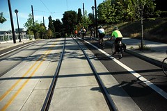
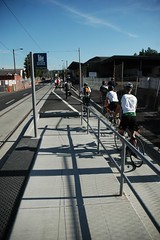
Our destination on the South Waterfront was a newly designed streetcar platform. Looking to improve on the the platforms on NW Lovejoy St. (where cyclists must ride up on the sidewalk), the new design allows bicycles to flow through unimpeded to the right of the platform.
The design creates a bike-only channel that is buffered by curbs on both sides. This is expected to be a headache for maintenance crews (their sweepers won’t fit), so Geller expects PDOT will have to look into new, smaller sweepers if debris becomes an issue.
Heading back north, we rode the new bike lanes on Naito Parkway. I have previously shared my feelings about the gap in the bike lane under the Steel Bridge, so I made sure to ride this section with Geller to hear his take on the situation.
Geller says the reason the gap happened was because funding for the Naito project ended at NW Everett. He added that PDOT is working to fix the gap and that the problem exists only in the southbound direction, where PDOT engineers will work with the city’s freight committee to figure out a solution.

options under the Fremont Bridge.
(File photo)
From Naito, we pedaled over the Broadway Bridge and made our way to below the Fremont Bridge via River Road. Geller pointed out the challenges in connecting the undeveloped “Cement Road” with Swan Island. It has the potential to provide a safe and direct alternative to N. Going Street (which is hilly and full of high-speed traffic), but the road is busy with freight trains and cement trucks.
The ride continued on to explore the Rose Quarter connection. Funding and alignment of a good route through this area — that will connect North Portland to the Esplanade — has remained an unanswered question for years.
Other stops and discussion included: how to cross from the Lloyd District to the Central Eastside Industrial District; debating the merits of SE 3rd Ave. as a way through the industrial area; and a look at how the Brooklyn neighborhood uses SE Clinton to connect to the Springwater Corridor Trail.
After the ride, participants joined Geller for mapping exercises and continued discussion at a local watering hole.
You can download a map of the route (with notes by Geller), on PDOT’s website. For more photos of the ride, check out my gallery.


Thanks for reading.
BikePortland has served this community with independent community journalism since 2005. We rely on subscriptions from readers like you to survive. Your financial support is vital in keeping this valuable resource alive and well.
Please subscribe today to strengthen and expand our work.
\”a newly designed streetcar platform…the new design allows bicycles to flow through unimpeded to the right of the platform. The design creates a bike-only channel that is buffered by curbs on both sides.\”
This section is sooooo sweet. I rode thru here about 6 weeks ago just to check this out. Very nice and well designed. This is EXACTLY what we need at the Bus stop/Bike Lane overlaps around the city. It would provide a safe and efficient solution to what is now a sketchy proposition for both parties.
Glad to hear your getting the ear of those in the position to help us out… Way to go Jonathan!
I was down there near the OHSU building and saw this ride go by. I wondered what it was.
As a note – the whole group blew through three different stop signs while I was watching.
Where was that enforcement action, huh PDOT and PPB?
🙂
I\’ll have to go check out that platform; I\’ve always had mixed feelings about public transit stops as riding by them is often an uncomfortable point in my ride, but at the same time I appreciate the trimet system both adding to my own mobility and allowing many of my non-cyclist friends to live nearly car-free lives.
I am pleased to hear about designs that facilitate better interactions between cyclists and public transport, and look forward to seeing it for myself. ^_^
The center spoke of city centric plan should be clean air. Every morning I walk or bike past idling vehicles. Today I walked by the Police station and there was an idling Police car with nobody in it? Does the city have a no idling policy?
I so wanted to go on that ride, but i had to work.Is there going to be any input from the commumity about what\’s going to happen?
Those gutter\’s(mentioned above) by the way are ludicrous and a waste of money….
The gutter on the stairway going from the Waterfront up to the Burnside Bridge sure made it easy for me to push my tallbike up the stairs. They would probably work well for a loaded touring bike, too. I like them.