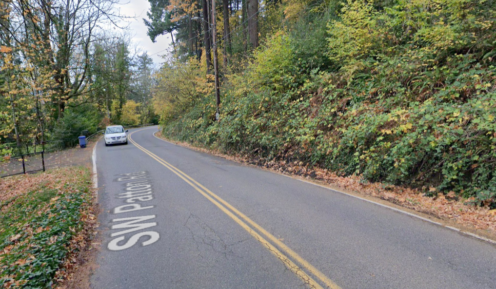
I’ve got a pretty strong stomach, but it lurched when I read BikePortland regular Mark McClure’s comment about his recent experience walking down SW Patton. Apparently the Apple Maps walking instructions led him to a disappearing shoulder on this unwalkable road. Where did Apple think it was going to send him, Scholls Ferry? The horror.
There were several stretches where I could barely find a shoulder to walk on. In a few cases, I had to cross SW Patton from the left side (facing oncoming traffic) to the right side to even find the shoulder. The crossings where I had poor sight visibility were especially unnerving.
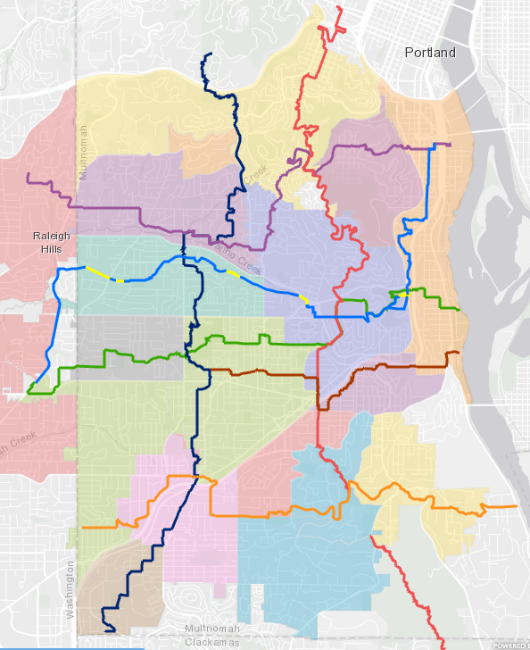
Folks, don’t rely on Silicon Valley to mediate your southwest walking experience. Instead, turn to your friends at SW Trails PDX. What would have helped Mark was the SW Trails Urban Trails arcGIS map which guides you to “low traffic streets, parks and key unbuilt rights-of-way linking walkers to schools, shops, parks and public transit.”
There are many lovely walks in SW Portland, in some ways it is a walker’s paradise, but don’t go it alone. Most southwest collectors and arterials don’t have sidewalks—on either side of the road. (At 26%, Southwest’s sidewalk coverage on collectors and arterials is less than half that of East Portland). Chasing disappearing shoulders by making multiple crossings is, unfortunately, the norm on the larger roads here.
Happily, almost 30 years ago a small group of plucky residents set out to provide an alternative to the second-class status of the walker in this auto-centric environment. What they built is a true grass roots organization fueled by a lot of volunteer labor. Today, SW Trails has a walking map of nearly fifty miles of wayfinding-signed trails, and their accomplishments include conceiving and securing funding for the 4T trail loop (Train, Trail, Tram and Trolley).
In addition to their twice-monthly guided group hikes, SW Trails responded to pandemic disruptions by launching a series of 35 self-led hikes covering over 200 miles of unique SW Portland hikes.
Mark, I’m glad you made it home okay. I hope you, and everyone else, can find time this summer for a SW Trails self-guided hike through Southwest Portland.


Thanks for reading.
BikePortland has served this community with independent community journalism since 2005. We rely on subscriptions from readers like you to survive. Your financial support is vital in keeping this valuable resource alive and well.
Please subscribe today to strengthen and expand our work.
SW Trails the organization isn’t without its faults. They are heavily against the dedicated bus lane that will go through Hillsdale and the members are leading a petition against it https://www.hillsdalenewspdx.com/post/petition-circulating-for-rose-lane-delay
I am confused why an org so dedicated to providing pedestrian access (even if it is for mostly recreational) would be so against projects that takes space away from cars to make a better experience for those walking/biking/taking transit.
Yes SWTrails seeks to delay the the Rose Lane Bus Project on Capitol Highway because
1. PBOT admits it is not needed under present traffic conditions (there is no delay) and will not be needed for two years (and we wonder if it will be needed at that time given the changes in working patterns).
2. The Rose Bus Lane will eliminate one lane of Capitol Hwy going into Hillsdale which local businesses (which we strongly support) feel will have a serious impact on business.
3 The elimination of one traffic lane on Capitol Hwy will likely have the adverse impact of much more impatient commuter vehicle traffic on several very curvey, narrow streets with no sidewalks. This affects the walkability of these streets and decreases the quality of life for those many residents.
4. It will likely shut off traffic from Burlingame Ave westbound which will add to the vehicle miles traveled for many home owners. The same will be true for PBOT Estimated diverted traffic.
PBOT seeks to ignore these important issues as it focuses on providing bus riders a minute or two shorter ride. They seem to regard them as unimportant collateral damage!
Don, I can’t tell you how many times I’ve sat on a bus as it crawls up Capitol Hwy to Hillsdale, fighting to get to the stop at Sunset. Why should the 20-30 people who have gone to the trouble of taking the bus (or have no alternative to the bus) wait and wait and wait in traffic for all of the people driving alone?
You’re damn right! – those bus riders SHOULD get a minute or two shorter ride, and the people who can’t be bothered to get out of their cars SHOULD wait and give the bus riders priority. We SHOULD be promoting the bus over cars. Have you not noticed that there’s a CLIMATE EMERGENCY?
The impacts on business etc are purely hypothetical – you have no evidence that any of those bad things will happen. At least give the rose lanes a chance, and then if all of those terrible things you fear happen (they won’t), PBOT can adjust.
You’re taking a very myopic view here that is not worthy of all the good SW Trails has done especially promoting walking in SW Portland. So odd to see a walking organization promote DRIVING as the chief means of getting around. All of those bus riders are WALKERS.
1 . By that logic that means there also isn’t going to be a reduction in car traffic through Hillsdale so makes no impact to you.
2 . Study after study has shown businesses do better with less car oriented traffic (like the one just reported on in Portland itself https://bikeportland.org/2022/07/07/psu-and-metro-study-shows-active-transportation-investment-helps-the-economy-358721).
3 . No one wants to drive on those crappy side streets, like you said “very curvey, narrow streets” are not condusive to being cut through streets. They will just take Barbur/Bertha instead. PBOT has also offered traffic calming measures on “impacted” streets.
4 . Maybe they should try walking to Hillsdale instead of relying on a 2 ton polluting vehicle, I hear of a great org called SW Trails that promotes walking 🙂
Hi Pigs,
To the north of Hillsdale is the city’s largest employer, OHSU– Barbur/Bertha doesn’t get you there.
Drivers heading to OHSU should take Cap Hwy to Terwilliger. I imagine the cut-through would be to get on Cheltenham from Sunset, and take it to where it intersects with Terwilliger, to the north of Cap Hwy. That would be an appealing route for drivers who live east of Scholls Ferry, and north of BHH. Obviously, there aren’t sidewalks on Cheltenham, and it is narrow and curvey.
The Southwest in Motion (SWIM) website was updated this month. I notice on the Crossing Projects map that there are a couple projects in this vicinity which are “Planned,” but not not in the more favorable “Active” or “Completed” status. If I were PBOT, I would hop to with those projects, C-28 also.
As pigs correctly pointed out, the road surface on Cheltenham and other side streets is HORRIBLE. Any driver who wants to take a car through there will probably do it just ONCE and never try it again.
Side-street cut-through traffic is always Don’s objection to every transit project in SW Portland – he raised all of the same objections when he opposed the MAX line on Barbur, which he helped to kill off.
It’s true that no one likes cut-through traffic but we should be trying everything we can to improve bus travel times so that more people will get out of their cars and onto a bus. When the imagined cut-through traffic happens (it won’t), PBOT should seek to mitigate it. But our default position shouldn’t be, “We can never do anything b/c there might be cut-through traffic.”
SW Trails, Hillsdale NA, and Hillsdale Business Association are on the wrong side of history as well as good common sense in opposing the rose lanes.
always fun mapping a cycling route to council crest & seeing what slopes you end up with depending on your start
This site has been a huge boon to my experience walking in Portland. I don’t bike but I do walk everywhere and having only recently moved it was a challenge at first. I couldn’t agree more that the big digital maps (Google, apple, waze) are dangerously bad in the area and sent you just insane routes. I’ve had Google maps navigate me to walk i5 on foot.
However, after getting my free maps kit from SW Trails I was able to carve out several loops of varying difficulty and even found 2 different route from my home to the river.
Portland is one of the most offline cities I’ve ever been and I love it.
What’s interesting is that every once in a while maps will refuse to give walking directions going the wrong way on a one-way street.
Another unfortunate outcome of how maps apps work is how bicycle directions vary depending on the usefulness of a route as a driving go-around when the freeway is backed up. For example, Google maps directions between Interstate / Willamette and Interstate / Multnomah. There’s a bike lane all the way, it’s downhill, and it’s by far the fastest route, but Interstate is also the first go-around suggested to drivers when I-5 backs up, so we get this instead:
https://www.google.com/maps/dir/45.5619272,-122.6822385/45.5290714,-122.6657658/@45.5446819,-122.6786763,14.58z/data=!4m2!4m1!3e1!5m1!1e3
It’s not just Interstate. When traffic is bad enough that maps-directed drivers inevitably plug up Interstate as well, Google sends drivers around on Vancouver and Williams, and then moves bicycle directions over to Rodney and Michigan.
Anyway, the point. Walking and bicycling directions act like an under-invested afterthought for driving-first apps. They appear to be coded as “slow cars” with access to special routes. Pedestrians (usually) get a conditional ability to ignore street directionality. Bike lane markings are treated as a mode preference rather than a parallel facility. Pedestrians are assumed to not interact with car traffic, because they’re on the sidewalk. Sidewalks aren’t on the map, they seem to be assumed to be a native feature of all roads, so Patton seems like a perfectly cromulent place to go for a walk.
Thanks, Lisa! I seldom use mapping services to plot the routes for my long walks in the metro region. However, I was interested in the most direct route from NE Portland to Beaverton, which was my original destination, so I figured I’d give the service a try. Big mistake! As you noted, Apple Maps was also going to have me continue along SW Scholls Ferry Rd.
Had I looked at my PBOT SW Portland Walking Map (see attachment), I would’ve seen the gap that I’ve flagged. And if I’d flipped my map over to the SW Portland Bicycle Map, I would’ve seen that SW Patton is a “Shared roadway (very high traffic – over 5000 vehicles per day).”
Since my PBOT map is now dated (4/2014), it’s good to know about the SW Trails Urban Trails arcGIS map. And I’ll definitely look into the 35 self-led hikes.
Finally, here are the photos I took on my walk. I’ll apologize in advance for my poor site performance. I’m working on it… I rambled around downtown for a while, which is why I had to shorten my destination. As you’ll see near the end of the album, I walked by the SW Trails 7 and 4T Trail signposts 🙂 I’ve walked the 4T loop several times and highly recommend it to others.
You’re a good sport Mark, thank you for your contributions to BikePortland Comments!
“Chasing disappearing shoulders by making multiple crossings is, unfortunately, the norm on the larger roads here.”
This is so true, and so inconvenient and dangerous. On top of that, laws are skewed against pedestrians who walk on roads. And their general “walk on a shoulder if provided, walk facing traffic if not” makes some sense on paper, but not in the reality of SW roads.
For example, if there’s one shoulder, so you’re walking with traffic, then that shoulder ends for 20 yards before resuming, it looks like the law says you must cross to walk against traffic for that 20 yards then cross back (your “multiple crossings”).
Or, if there’s no shoulder, so that you should be walking facing traffic, there’s nothing I find that allows you to deviate from that even when it means walking into traffic on a blind corner, whereas walking with traffic on the outside of the curve would let you see cars approaching and drivers see you.
Overall, when walking or running on curving, treed SW streets, it seems there are often conflicts between what’s legal and what’s safest.
Thanks, Lisa, for pointing out the paucity of walking and cycling infrastructure in Southwest. Every time I hear people from East Portland complaining about their lack of … everything, I have to laugh. Southwest is the DIY part of Portland: maintain your own streets and get yourself places b/c there’s almost no bus service and no cycling or walking infrastructure. No wonder almost everyone drives everywhere and just a few intrepid souls walk and cycle.
Thanks to Mark for sharing his experience, it helps to see a situation we are all used to through fresh eyes.
I strongly opposed SW Corridor because it did not include a planned route for the Red Electric Multimodal Trail that would be off Barbur. Metro and PBOT BLOCKED IT FROM BEING FUNDED AS PART OF THE SW Corridor, meaning it would never be built. PBOT has declined offers to discuss the Red Electric Route east of Hillsdale which was approved by the City Council on 2007! They have never to my knowledge articulated a reasonable strategy for bikes other than a totally rebuilt Barbur.
SWTrails has figured out a interim approach to solving this conundrum by using the current Barbur Newbury Bridge and a local street above Himes Park, one of the City Council approved routes for the Red Electric.
Bike and Walker safety for SW Portland and Washington County residents will be greatly improved once PBOT gets off their high horse and works with the community.
Don Baack Founder SWTrails