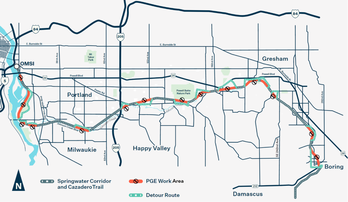
Portland General Electric is upgrading transmission towers and the work will lead to several closures of the Springwater Corridor path from now through mid-March.
A PGE spokesperson says path users should expect short rolling closures and detours Monday through Saturday from 7:00 am to 6:00 pm while the work is being done. Two weeks notice via signage on the path has been promised as well as detailed detour information. They’ve even created an interactive map that will be updated every Wednesday morning through the length of the project.
Advertisement
The work is expected to begin near Boring and work its way west toward OMSI in Portland.
If you have any questions or concerns, call PGE Customer Relations at 503-612-3730 and reference project #P36762.
“When our work is done, your energy will be safer and more reliable and take us one step closer to Oregon’s clean energy future. Thank you for your understanding and patience,” says PGE.
For more details, visit the project website.


Thanks for reading.
BikePortland has served this community with independent community journalism since 2005. We rely on subscriptions from readers like you to survive. Your financial support is vital in keeping this valuable resource alive and well.
Please subscribe today to strengthen and expand our work.
I’m glad PGE is doing this in winter instead of the prime riding months of the year.
This!
My favorite ride during the spring/summer is out to the Gresham Farmer’s Market with my significant other via Springwater. She’s hesitant to ride with me anywhere else in East Portland, but loves to ride Springwater.
The detours are a great way to explore the surrounding neighborhoods.
I hope to ride it again some day. I gave up on the Springwater when the number of campers got too intimidating about a year ago.
Gresham has done a good job of keeping the drug camps out its portion of the Springwater corridor. There essentially aren’t any east of Powell Butte.
If little old Gresham can do it why can’t Portland?
I gave up riding the springwater when access from NE via the 205 path became too intimidating for family fun.
Clicked into article expecting to be downtrodden, and am exiting feeling fine! Sounds like short closures, and well planned. That map link actually breaks down project progress (ex. what’s closing within two weeks) quite well.
The public notice is appreciated!
Where did the map in the article come from? It’s not the same as the interactive map, or the one on the project website.
I ask in particular because in the map in this article, it shows a small portion south of Powell that is to be closed without any detour provided. That closure doesn’t appear on the interactive map that I can see.
I ride the springwater in the summer when the days are longer. There isn’t any lighting on it where I am (92nd and Flavel) and I don’t feel safe riding home alone on it in the dark.