Cycling advocates raised major concerns about construction detours and closures that will be required for the Burnside Bridge replacement project.
“That’s not just a nice bit of recreational area. For many people, it’s their main route through the city.”
— Iain Mackenzie, Bicycle Advisory Committee member
Multnomah County planners and staff shared a presentation about the project at a joint meeting of the Portland Bureau of Transportation pedestrian and bicycle advisory committees Tuesday night. The county is nearing completion of their federally-mandated Draft Environmental Impact Statement. As part of that work they have to assess community impacts related to construction.
“We know that the eastbank Esplanade is going to be affected in a big way,” said Mike Pullen with the Multnomah County communications office. “We don’t know for how long yet, but kind of the minimum is about a year-and-a-half, and the maximum would be the full length [four-and-a-half years] and I don’t think any of us want to see that happen so we’ll be looking to reduce that closure as much as we can.”
Advertisement
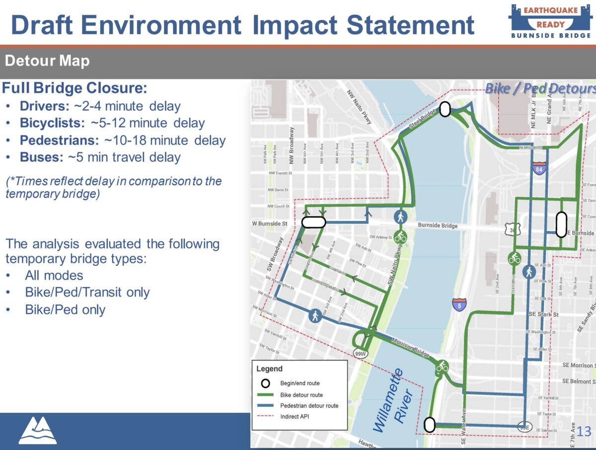
On the east side, the county has mapped out a detour (at right) that would route Esplanade users onto SE Water Avenue near the Morrison Bridge on the south end, then onto 3rd and over to 7th where riders would take the new Blumenauer Bridge onto Lloyd Avenue then back west to the Steel Bridge. County estimates say the detour would add a five to 12 minute delay for bicycle riders. Estimated delay for auto users is two to four minutes, people on foot would have a 10-18 minute delay, and the detour would delay bus riders by about five minutes.

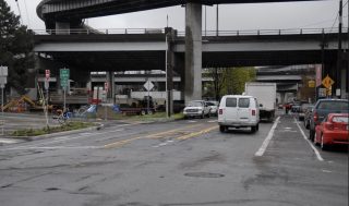
(Photo: Jonathan Maus/BikePortland)
Bicycle Advisory Committee (BAC) Chair David Stein spoke up in the meeting about the need for auto traffic diversion and upgrades to those surface streets to maintain rider safety. “We’re taking away very low-stress routes in the form of Waterfront Park and the Eastbank Esplanade and replacing them with something that at best is going to be, medium, and in some cases, high-stress [like the unprotected bike lanes on Water Avenue].”
BAC member Iain Mackenzie said he feels the planned closures of the Esplanade are “completely unacceptable.” “That’s not just a nice bit of recreational area. For many people, it’s their main route through the city.” In addition to fast-tracking already-planned protected bike lanes on SE Water Avenue (which were adopted with a “6-10 year” construction priority in the 2018 Central City in Motion plan), Mackenzie suggested that the county consider opening up an Oregon Department of Transportation maintenance access road between I-5 and the Willamette River to get people around the construction zone.
Advertisement
County Project Manager Steve Drahota was appreciative of the feedback and clarified that the 18 month closure estimate would not be continuous. The closures would be “intermittent” and “six months here, six months there.”
“We know we will need to push hard to limit how long it is closed and look for ways to safely keep it open when possible.”
— Mike Pullen, Multnomah County
Reached after the meeting, Pullen said, “It’s clear that the proposed closure of the Esplanade is going to be a very big concern… We know we will need to push hard to limit how long it is closed and look for ways to safely keep it open when possible during construction of the bridge overhead.”
There’s still time to figure out this problem. The county plans to hire a contractor to build the bridge at the end of this year and construction isn’t going to start until 2024. Pullen said traffic planning and detour details will be finalized during the design phase of the project which will start early next year.
The Draft EIS will be published later this month and then a 45-day public comment period and online open house will begin. That’s the best place for more folks to share their concerns and ideas about this issue.
(Note: We’re also tracking a key decision about access from the new bridge to Naito Parkway and the Esplanade. As we reported back in October, the county is considering many options and those discussions are ongoing. The county did not share an update about it the meeting Tuesday.)
— Jonathan Maus: (503) 706-8804, @jonathan_maus on Twitter and jonathan@bikeportland.org
— Get our headlines delivered to your inbox.
— Support this independent community media outlet with a one-time contribution or monthly subscription.


Thanks for reading.
BikePortland has served this community with independent community journalism since 2005. We rely on subscriptions from readers like you to survive. Your financial support is vital in keeping this valuable resource alive and well.
Please subscribe today to strengthen and expand our work.
Oh, well as long as the closures are only “six months here, six months there” it’s like nothing is happening at all! /s
Steve Drahota is using the word “intermittent” pretty generously.
Excellent reason for an interim study on PBLs for Water Ave and MLK/Grand.
I might be missing something, but if you were traveling north along the esplanade, couldn’t you cross the Hawthorne, ride Naito, then cross the Steel and meet back up with the path? Seems easier and safer than the detour proposed. Again, I might be missing something, but it seems like no matter what way you were traveling, going across the Hawthorne and Steel and riding on the westside seems easiest.
That should be the compromise. Phase construction such that either the Esplanade or Naito are open at any given time. I don’t think that’s an unreasonable request…
How much time do you think that would add to the commute?
My non tested estimate is an average of 4-6 min added time on a bike and 10-12 min added time walking. Other non-motorized modes of travel would fall somewhere in those ranges. Its not ideal, but also not the end of the world if the westside route is open. Its safe and easy to navigate IMO.
I do that all the time except I usually take the path along the water since I don’t like Naito. Honestly I don’t like the east side, since you have to go over those bumps on the floating bridge part. Hitting those things at high speed can knock off panniers, water bottles, etc.
Quick googling indicates the project budget is around $800 million, and there’s not enough to build a floating path to detour around the construction? Could be a permanent addition to the Esplanade.
If they cared about pedestrian/cyclist access during construction, they would at least attempt to contact Union Pacific about a temporary easement along the mainline between Stark and the Esplanade just north of the floating portion. There is sufficient ROW for an 8ft path, and a temporary fence could be installed to separate the trail from the tracks.
This.
I ride the section of SE 3rd in the detour almost every day because of where my work is located (near the east Burnside bridgehead). Unless they are going to kick out a bunch of freight occupants and significantly upgrade the road, there is absolutely no way that is going to support any kind of regular bike traffic.
As it stands now a line of Sheridan freight trucks permanently blocks one lane of traffic on SE 3rd between Stark and Oak — you can see it here in Google Street View: https://goo.gl/maps/FtEUQKmiuz4rdPA87 — meaning bicyclists get to negotiate with oncoming cars using these streets as cut-throughs.
There are no sidewalks along much of this stretch, meaning people are parking and walking in the street pretty often (there are a few small shops, architecture firms etc. along here). There are stop signs on 3rd at Ash and Ankeny, and the large warehouses built out to the curb block sight-lines, meaning the only safe thing to do is come to a complete stop and then inch forward.
Between Ash and Ankeny there is old belt-line rail embedded in the street, and all along this stretch the street is gouged out by decades of industrial use.
It’s a terrible part of the ride and I only do it because I’m young and stupid and impatient. It should not be any kind of official bike route, temporary or not.
My understanding is that that ROW is owned by ODOT, not UPRR. I asked about this at the BAC and the project team seemed open to considering it as an option, but did say they were also looking at using that as a route for construction vehicles.
I guess that would be an issue. If the path needs to be wider to accommodate vehicles, they may need some space from UP. Railroad ROW is generally 50ft, so there should be some room on this double-tracked section.
This highlights the institutional disconnect in how many (if not most) US departments/ bureaus of transportation view dedicated bicycle and pedestrian facilities…as a “supplemental” or “recreational” facility and not the regional “bike/ pedestrian highway” that it functions as (and the agency PR highlights it as). This is sadly also reflected in how departments classify such on their arterial hierarchy maps that influence TIP, maintenance and work zone planning too.
PS. This situation sadly reminds me of conversations I had with ODoT staff back during the long term Interstate Bridge closures for maintenance back in the 2000s…I asked them why they did not have one side opened and clear for bike and pedestrian traffic and they said that the alternative route was I-205 (40 mile loop)!
I think Iain’s recommendation to fast-track the CCIM build-out is on point. Since bridge construction will not begin until 2024 the appropriate government institutions will have plenty of time to quickly (but thoroughly) build the infrastructure laid out in the CCIM plan. And now that the Biden administration is in place with Mayor Pete in charge of transportation, it is time for PBOT and ODOT to work on securing the necessary funding.
Fast-track the CCIM project?
Let’s not forget the EPIM projects that have been delayed time and again. There is still roughly $26 million needed to finish unfunded projects in that plan. If equity will be a large part of PBOT’s mantra going forward, let the CCIM rest and finish the EPIM projects that were promised. Let’s not have business as usual at PBOT.
Nobody is suggesting diverting resources away from any EPIM projects. What I said is that in CCIM there is an adopted plan to make a 2-way bicycle facility on the west side of Water Ave. By the time the new Burnside Bridge is under construction we will already be in the 6-10 years phase of CCIM. The county should coordinate with PBOT to ensure that there is at least a temporary installation of the Water Ave facility before any closures of the Eastbank Esplanade.
I would be fine with this if they paired it with solid (permanent) improvements to the detour route, including all of 7th. I would rather have protected connections within the Inner Eastside than an interim route along the water, if that’s the choice. I hope shutting down the Esplanade will force PBOT & Metro to prioritize those improvements.
There are quicker ways to get to the Steel Bridge without detouring all the way east to 7th, for example, crossing the Banfield and the RR tracks on the MLK sidewalk.
That doesn’t really work as a detour for thousands of daily cyclists. I would expect some pedestrians to use the MLK viaduct, but it’s going to fill up and be difficult for cycling.
‘Thousands of daily cyclists’ aren’t going to want to ride all the way uphill to 7th from the river front just to have to go back down to the Steel Bridge; they are going to find other routes that are shorter and less hilly.
Many of the thousands of us (so some number of thousands) who ride this daily never cross the river, but commute N-S along the East Side. We don’t care about accessing any of the bridges — we need to get from inner SE to NE/N Portland (or vice versa). The assumption that travelers are mostly headed to/from downtown rears it’s ugly head again. Anyway, I think detouring to MLK makes absolute sense, as long as we take one of the lanes currently used for car parking and turn it into a two-way cycle track (and yes, have a dedicated cycle lane on the bridge across I-84 because the sidewalk won’t be wide enough).
Waaaaaaaaaaaaa. Babies need a bottle?
You seem nice.
When Multnomah County built the Sellwood Bridge, as I recall people thought the bike detour on the west side was abysmal. After the bridge was built, the Greenway Trail on the west side associated with the bridge construction was delayed in opening, then opened for one day, then closed again for several weeks due to some problem the County hadn’t noticed.
So this seems like the County is continuing its pattern of being horrible at detours and ancillary aspects of its projects (and definitely views people walking and biking as ancillary).
Across the Willamette in Portland, Multnomah County owns the Sellwood, Hawthorne, Morrison, Burnside, and Broadway bridges; ODOT owns the Ross Island, Marquam, Fremont, and St. Johns bridges; UP owns the Steel Bridge; Trimet owns the Tilikum; and BNSF owns the other railroad bridge. The City of Portland doesn’t own any river bridges. If you live in a port city along a major river, you are naturally dependent on bridges that have to be opened to taller ships or tall enough to let them pass under, and each bridge must be closed from time to time for both preventative maintenance and periodic rebuilding or replacement. The Burnside Bridge is of a type that will not survive a major earthquake, so preventative maintenance will only go so far before you must replace it (the same is true of the Morrison Bridge). When bridges are closed for repairs or replacement, it’s inconvenient, but not the end of the world – you have lots of other options.
This project was announced years in advance; it takes the county many years to raise $800 million for a bridge replacement. They had numerous public meetings about the project that apparently no one attended. They are now giving you 3-4 years to prepare for detours, which is pretty good by Vogon Constructor hyperspace bypass standards.
$825 million to replace ONE bridge? I do not recall the robust public debate and public being buying in to that agenda item.
You people do realize money (especially local money) does not grow on trees. If big government progressives are to make people believe they are worthy of entrusting with the public’s hard earned money they have to be good stewards first.
If you asked 100 people in Portland to spend nearly a billion dollars, I would wager that precisely zero would suggest a new Burnside Bridge. It is a solution to a problem no one is asking in response to a theoretical event which may or may not happen in the next 100 years. You know what else may or may not happen? Runaway climate change or global thermonuclear war. We have some of the worst public schools in the nation, a pretty sad parks system, miles of unpaved streets and people living in squalor. So why is this the most pressing of all issues again?
Someone should question why the new bridge is expected to cost $1 billion (with overruns, it will) when the Tillikum bridge cost around $135 million. I think that’s a far more pertinent question than what the Esplanade detour will look like.
Perhaps we’ll hear its because because the new bridge is intended to withstand the once-every-few-hundred-years CSZ earthquake. But so is the Tillikum. And the Tillikum is lovely too.
Suppose it actually is impossible to build an earthquake-resilient bridge at Burnside for less than $1 billion. That begs the question: why do we need to spend $1 billion on a bridge that we “think” will withstand an earthquake that, according to the geological record, comes every 200-400 years?
Suppose we simply use the current Burnside Bridge until the CSZ earthquake – which may come in our lifetimes or not. After all, we just spent hundreds of millions of dollars reburbishing it.
If it is destroyed – as seems very likely – then we can spend *much less* to build a new bridge that don’t need to withstand the CSZ – because the next one will be many hundreds of years away.
But how will we cross the river while the new bridge is being built? Well, the Tillikum, or ferries, or – wait, how does the US Army send dozens of main battle tanks over a big river (the Rhine, or the Volga) when the bridges are bombed out?
Floating pontoon bridges, carried on trucks, get deployed in a day and the M1 Abrams are growling across by nightfall. Maybe we could buy a few of those and stash them in warehouses for the big day. And save a billion dollars. Or spend a billion dollars on bike lanes.
Honestly, our government spends like money is free, then turns around and tells us there’s no money for humane houseless camps, mental health treatment, small business assistance, or all the things that we need way more than a billion dollar bridge.