The Portland Planning and Sustainability Commission (PSC) will hold two virtual public hearings on the West Portland Town Center Draft Plan, on September 14th and 28th. The commission encourages Portlanders to comment on the plan to help inform its possible amendments. The amended draft goes to City Council early next year for adoption.
For those who want better bicycle facilities, the WPTC plan includes a few transportation improvements which could use your support:
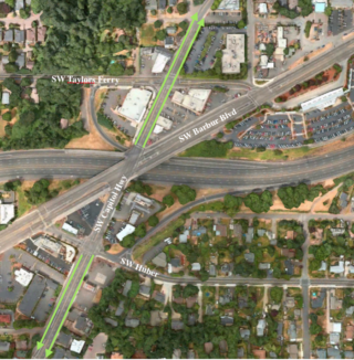
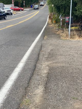
The bike facility gap on SW Capitol Hwy between SW Barbur Blvd and SW Huber St. As BikePortland has reported, the Portland Bureau of Transportation (PBOT) has committed to improving SW Capitol Hwy for active transportation, including: The ongoing $27.5 million, mile-long, SW Capitol Hwy project with its continuous sidewalk, protected bike lane and multi-use path; the completed Capitol Hwy road diet between SW Huber St and Kerr Parkway; numerous past and ongoing improvements to Cap Hwy in the Hillsdale Town Center.
Advertisement
Yet, after all this investment, this strategic north-south corridor from Lake Oswego to Hillsdale will still have a bike facility gap at its most dangerous stretch, between the ODOT owned intersection at SW Barbur Blvd to SW Huber St.
You don’t need to design a solution, just let the Commission know that filling this gap is a priority for you. (The Town Center plans roll out over decades, so be bold!)

SW Taylors Ferry is a dangerous street lacking bike lanes and sidewalks. It intersects with SW Capitol Highway near Barbur, and receives car traffic from a southbound I-5 exit ramp. The plan calls for widening the shoulder to include a protected bicycle lane and sidewalk.
SW Huber St is the only East-West connection between Barbur Blvd, SW 35th Ave and points east. The plan includes a bikeway and sidewalk, and an I-5 on-ramp-crossing.
The Bureau of Environmental Services (BES) also identified these projects as priorities for near-term implementation, with Taylors Ferry as its highest priority (BES memorandum, Appendix E). “The other projects are critical for improving transportation safety, especially for people walking, rolling, and biking, but are lower priorities for BES.” (The Taylors Ferry active transportation project overlaps with a BES Woods Creek culvert replacement project.)
These projects and others have brief description at the end of the WPTC draft plan, between pages 105 and 111.
The first PSC hearing is tomorrow, those wishing to provide oral testimony will need to sign up by 5:00 PM today.

— Lisa Caballero, lisacaballero853@gmail.com
— Get our headlines delivered to your inbox.
— Support this independent community media outlet with a one-time contribution or monthly subscription.


Thanks for reading.
BikePortland has served this community with independent community journalism since 2005. We rely on subscriptions from readers like you to survive. Your financial support is vital in keeping this valuable resource alive and well.
Please subscribe today to strengthen and expand our work.
Maybe they should do like with Halsey and declare an emergency and start to implement improvements in fall 2031?
Seriously, I’d remove Capitol Highway altogether and add roundabouts at Barbur/Taylor’s Ferry and at Barbur/Huber; reduce traffic lanes on Burber in between the two roundabouts to one lane in each direction with no center turn lane, but add a narrow concrete median instead; and with the remaining right-of-way on the bridges maximize sidewalk space to accommodate both bicyclists and pedestrians.
Hi David,
I just uploaded a concept that urban designer Ian Lockwood did for BPS in 2012, Barbur Concept Plan, p. 45.
You might enjoy it. This is my idea of bold place-making. Not cheap. The “Hybrid Concept” at bottom seems to be similar to your suggestion.
They could come up with an affordable solution by giving up a few of the redundant car lanes. Take a lane off of Taylors Ferry and some of the spare ones off of Capitol. The cones thing they did to make half of Capitol Hwy be car-free worked great.
I wonder how much traffic calming would occur if they closed the freeway entrance? That would be super easy.
I haven’t been riding to work since December, but when I did, I went through this intersection every day. South West on Barbur then South on Capitol highway, then the reverse in the evening.
I found that this intersection requires “highly skilled” riding. It’s not a beginner’s route. There is a bike bridge that goes across 1-5 from the transit station to Huber, but again, that’s indirect.
Making the transition to Cap Hi from Barbur(in particular) involves not getting hit by freeway bound traffic, traversing the intersection – riding through a ton of glass on the far end, then making a super sketchy three lane – crossing, left turn to get to Huber (between the Starbucks and McDonald’s.
That is not something I’d want an inexperienced rider to forced to do. It’s fine if advanced riders are open to that, but this should not be the basic service to cyclists.
I’ve since moved, but used to live & work where I biked through this mess many times a week, and my pie-in-the-sky vision was always for a mega-roundabout for the cars, stretching from Taylor’s Ferry to the north all the way to the I-5 North onramp to the south, with a pedestrian paradise in the middle, Mt. Hood view and all. I have no idea what automotive access to businesses in the center would look like — and I still love & shop at Barbur World Foods weekly! — but I trust some civil engineer type somewhere could figure it out. Anyone? Anyone?