Earlier this month, we dug into what’s on tap for Barbur Crossroads — a mash of roads and highways in southwest Portland where the city and state are making big changes. One of the questions left unanswered was how people on bicycles riding north-south on SW Capitol Highway would get cross the car-centric chasm of ODOT’s Barbur (Hwy 99W) and I-5.
We now have a bit more clarity.
Advertisement
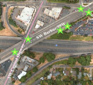
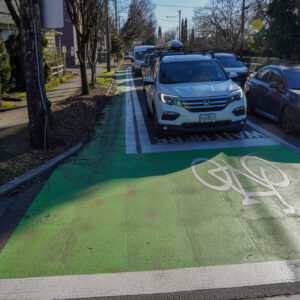
BikePortland has received more details of the bike facilities coming with the Barbur Crossroads Safety Project from ODOT Region 1 Public Information Officer Don Hamilton: The plan is to add conflict markings and bike boxes along the existing bike lanes on Barbur Blvd as it crosses Capitol Highway and Taylors Ferry. But there will be no new bike lanes.
This leaves an approximately 850-foot unmarked gap in the north-south Capitol Highway corridor.
Here’s Hamilton’s response to our bike lane queries:
No bike schematics at this point for bike routes because we’re not installing new bike lanes. But the project will add safety measures for people biking on Barbur Boulevard including green bike boxes and conflict markings in both directions across the Capitol Highway intersection, both directions across the Taylors Ferry Road intersection, and on the northbound side across the driveway to Barbur Transit Center. We’re also putting in new accessible curb ramps and push buttons for people crossing.
In lieu of an ODOT schematic, BikePortland annotated a map showing the location of the ODOT improvements (above).
The Barbur Crossroads Safety Project is funded by the All Roads Transportation Safety (ARTS) Program, which is “designed to address safety needs on all public roads in Oregon,” and involves collaboration “with local road jurisdictions.”
BikePortland will keep you updated on how the collaborating agencies, Portland Bureau of Transportation and ODOT, plan to guide people on bicycles through the Capitol Highway gap. Stay tuned.
— Lisa Caballero, lisacaballero853@gmail.com
— Get our headlines delivered to your inbox.
— Support this independent community media outlet with a one-time contribution or monthly subscription.


Thanks for reading.
BikePortland has served this community with independent community journalism since 2005. We rely on subscriptions from readers like you to survive. Your financial support is vital in keeping this valuable resource alive and well.
Please subscribe today to strengthen and expand our work.
There is likely some miscommunication afoot here. The project goes to bid soon and has fully developed plans, that also means the project is very unlikely to change at this point. There is a new bike box in the right lane for NB traffic along Capitol Hwy, with no connecting bike lane I’d assume it is there to ease access onto the roadway from the sidewalk/crosswalk.
So you are saying its at the 90% plan stage?
Pretty sure it’s at PS&E with June bid let. In terms of miscommunication it seemed like Lisa meant plans when she asked about schematics and Don interpreted it as some sort of sign or pavement marking.
I might be able to clear things up a little, but perhaps this is the start of next week’s article–poking around this morning I’ve answered one of my questions.
AnotherEngineer, I meant schematics, as in a simple graphic for the public. ODOT provided those at a Jan, 2019 meeting with the Crestwood NA, and they are the most detailed descriptions of the project I’ve seen.
In my first conversation/email with Don Hamilton two weeks ago, I sent him a few of those slides and asked if they were still relevant, he told me only the jughandle map was. I blockquoted his response to my followup email in the article.
And you’re correct about the late-stage of the ODOT project, I think it gets installed this summer. The bid on the PBOT Capitol Hwy from Mult Blvd to Taylors Ferry project was just approved by the City Council. That will roll out with a splash in June with a lot of information for the public.
Looking into the Capitol Highway projects, I’ve gone on a short journey from confused to perplexed, and this morning I think I’ve arrived at enlightenment.
What I discovered this morning is a third Capitol Improvement Project in the Mayor’s proposed budget for 2021-2022. That has a line in the CIP Summary for “Capitol Hwy: Huber-Taylors Ferry” with $30K proposed for 2021-2022 and $172K under “Revised 2020-21”–so it looks like PBOT is planning to close the gap!
Next week I will see if I can find out what PBOT is planning.
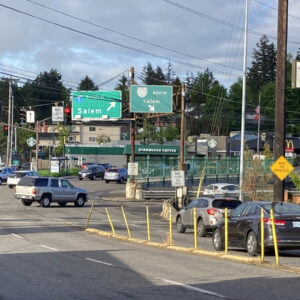
Remove the freeway on ramp, which has got to be one of the worst designed on ramps in Portland. There are other places to locate a SB on-ramp that would be safer for all.
What is this? 1995? You would think this isn’t 2021. well, Odot still acts like it’s 1995…
More like 1950.
If anyone was ignorant like me and curious as to what “conflict markings” are, I found this blog post:
http://www.mikeontraffic.com/bike-lane-conflict-zone-markings/
I think it means a sort of dashed-line where the existing bike lane is not marked at intersections. It feels ghastly that engineers call them “conflict markings” fully expecting and accepting conflicts between bicycles and autos, but here we are.