
(Source: Portland BPS West Portland Town Center Open House)
The Portland Bureau of Planning and Sustainability (BPS) is moving forward the West Portland Town Center Plan even though the Southwest Corridor Light Rail project — which was integral to the Town Center design — recently suffered a severe blow when the Metro funding measure was voted down.

The West Portland Town Center sits astride an area known as “The Crossroads” about five-and-a-half miles southwest of Portland City Hall where I-5, SW Barbur Blvd and SW Capitol Highway meet in a starburst pattern. As you can see in the image, the Crossroads is currently low-density, car-centric landscape. Realizing the plan’s vision would require extensive land-use changes including up-zoning within an area riddled with infrastructure deficiencies. As the Open House notes, “Fewer than 13% of the streets in the town center have sidewalks. Pedestrians and cyclists are forced to walk in the roadway or on narrow shoulders or use major streets with faster traffic and more frequent collisions.”
Advertisement

(Photo: Jonathan Maus/BikePortland)
The Town Center plan is considered a bold vision for a growing and diverse community. In addition to infrastructure changes, the plan aims to hasten development of housing options while greatly increasing the residential and commercial density of the area. Planners also hope to boost walking and bicycling facilities in the area which would lead to easier access to nearby businesses, parks, schools and public transportation.
The current lack of sidewalks and stormwater management systems extends deep into the surrounding neighborhoods, which also lack bike lanes, full service bus lines, and in some places, paved roads. This infrastructure deficit is a source of concern for some current residents and transportation advocates. They point out that the transportation improvements are unfunded and won’t automatically accompany the zoning changes. Their fear is a tenfold increase in density without the improvements needed to support it. (Note: The $26.1 million SW Capitol Hwy project, which is set to begin construction soon, connects with the West Portland Town Center just north of the Crossroads.)
Advertisement

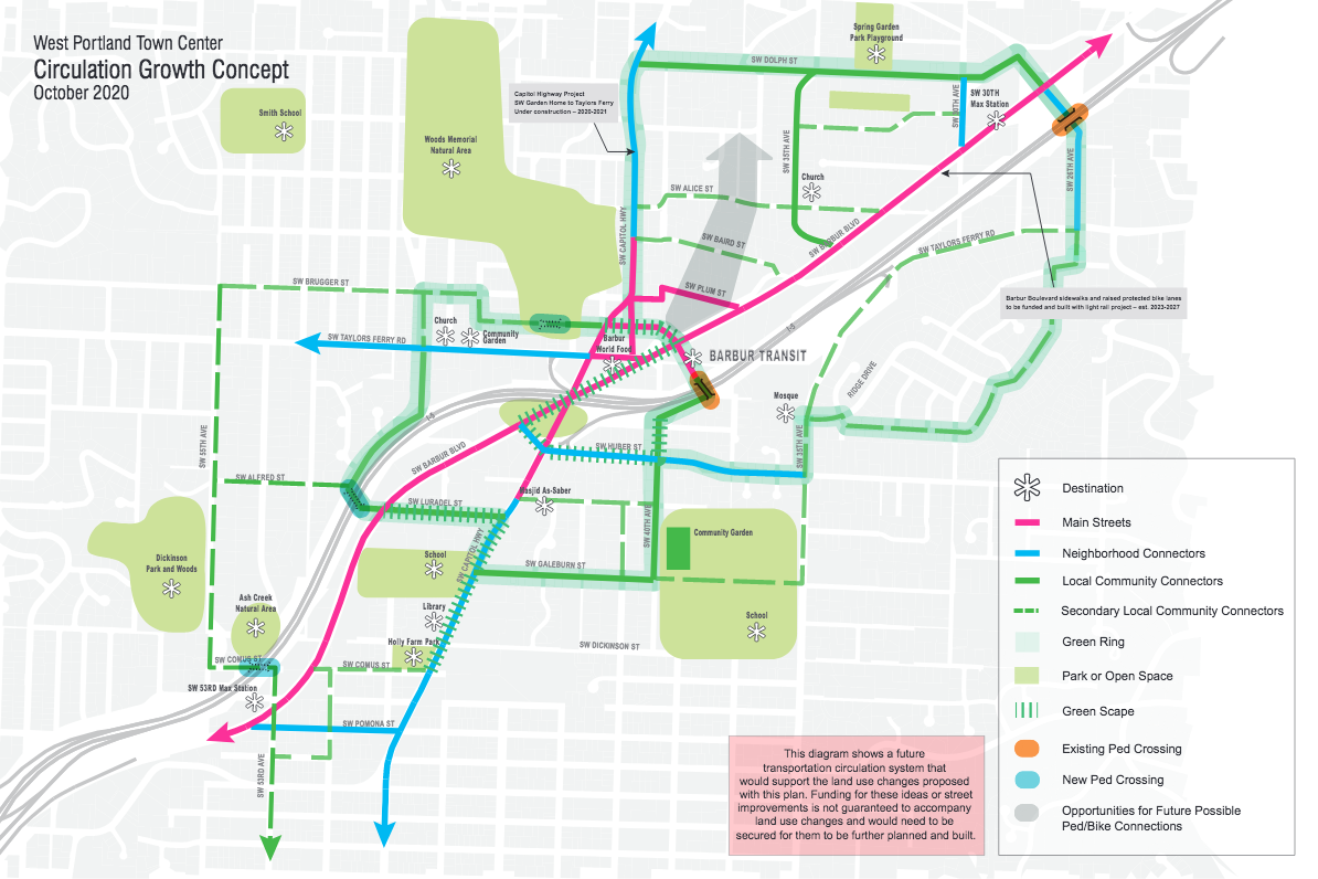

The online open house for the project includes plans for a “Green Ring” route around the center as part of its “Circulation Growth Concept” (pictured). BPS says the Green Ring, “combines increasing access to natural areas with greater pedestrian and mobility safety for walkers, rollers, and cyclists of all ages.”
If you live, ride or work in this area, make your voice heard. BPS is accepting feedback on the project through an online survey which closes this Thursday, December 3rd.
— Lisa Caballero, lisacaballero853@gmail.com
— Get our headlines delivered to your inbox.
— Support this independent community media outlet with a one-time contribution or monthly subscription.


Thanks for reading.
BikePortland has served this community with independent community journalism since 2005. We rely on subscriptions from readers like you to survive. Your financial support is vital in keeping this valuable resource alive and well.
Please subscribe today to strengthen and expand our work.
Note the ban on drive-thrus. sweetness.
Bans on drive-thrus make life harder for the handicapped that have trouble walking. Or do city planner not care about the handicapped?
They may be against the ADA laws, if not it should be.
When I was a little kid I lived a couple of houses up from the intersection of Alice and 35th and we did not say “meet me at the crossroads”, but we did say “meet me at the Piggly Wiggly,” which is now the Barbur World Foods and is pretty much at the center of the crossroads.
I just scarfed down a bunch of grape leaves, and have some spanakopita in the fridge. Barbur World Foods is a gem.
Nothing would make me happier than to see the “major” Barbur Transit Center not just be a giant surface parking lot. Also would love to see a better north-south connection between SW Alice St and the proposed new main street at SW Collins St.
“Their fear is a tenfold increase in density without the improvements needed to support it.”
This is a realistic concern. However, shouldn’t the development-associated fees fund a good part of the required infrastructure?
Good comment, anon. In theory, yes, it should. What happens in reality is a different matter.
Take, for a large example, the Zidell ship building yard on the South Waterfront. Here’s a 2017 blurb touting its future development:
By 2018, development plans were halted due to disagreement between the city and the Zidells over the cost of building a street grid and other infrastructure. So, there is always a negotiation for new infrastructure.
At a smaller, residential infill scale, the city seems to have stopped requiring SW property developers to improve their frontage with new sidewalks. Take a tour through the SW– Multnomah Village or SW Broadway Drive–once you become attuned to it, you will see numerous new or expanded structures without the sidewalk code requires to be built.
It’s a rabbit hole of an issue, but it boils down to inadequate stormwater facilities. The city doesn’t have the stormwater capacity in the SW to support building sidewalks and active transportation facilities for all the growth it expects (and would like to accommodate). If I remember correctly, about half the cost of the $26.1 M Capitol Hwy project is for stormwater.
Once you get outside of the CM2 and CM3-zoned lots along Barbur (which they’re counting on the LRT to improve with new sidewalks), there is a lot of RM2 and RM1. Improvements would come one lot at a time, if the city requires them. My impression is the city is actually requiring sidewalks more often then they used to, but the stormwater issue then cuts that aspiration back. Adding those swales at the cost of the property owner will likely discourage the development they expect in the swaths of RM1 they plan. I don’t think the neighbors need to worry about wholesale redevelopment in those areas. IMHO it’ll be rare that a builder takes advantage of that zoning.
Maybe that is an argument against increasing density.
Many planners forget that people voted 3:1 AGAINST density increases a few years ago. It was Metro measure 26-160.
Thanks so much for highlighting the open house. I live in this area, yet I hadn’t heard a peep about this project. I’ll visit the open house now.
BTW, I ride thru this horror show of an intersection every day, and you have to be truly brave to do it. I would never do it with kids on bikes. But since you have to take the lane on Capitol Hwy, the chances of right hooks seem much reduced. I would advocate some kind of shared lane for cyclists and motor vehicles, with MVs required to give way to bikes, somehow. But this intersection is trying to do so many things that it seems impossible to satisfy everybody – meaning it’s time to give bikes priority, for a change.
One other observation: The lack of commenters on this issue makes me think that most BP readers live downtown or especially in SE. Very few cyclists here in SW, which makes sense b/c there is almost no cycling infrastructure.
I don’t know how things are re cyclists in your neck of the woods. But near Beaverton-Hillsdale Hwy there are several prominent bike advocates. Also, e-bikes are really changing the bike commute in the hills. I see several retirement-aged commuters who can daily tackle intimidating hills with battery assistance.
I echo the concerns of this excellent article and many of your comments. The Bureau of Planning and Sustainability is accepting community input. This is our chance to ask them to create a plan to enable a fantastic WPTC.
Please REVIEW the WPTC DRAFT Plan and SUBMIT YOUR COMMENTs by Thursday, December 3rd
Survey https://www.surveymonkey.com/r/wptc-dd-openhouse
Email: wptc@portlandoregon.gov or Call: District Liaison Joan Frederiksen at 503-823-3111
Consider: Is this the right scale for the neighborhoods given:
1. SW Portland is known for poor and missing public infrastructure: streets, storm water, sewer, bike/ped facilities—even schools, public transportation and safety. The WPTC plan has builder fees funding infrastructure improvements and no guarantee they will be spent in SW Portland.
2. With no funding for the SW Corridor Light Rail System, our already stressed transit and the transportation system can only get worse.
3. At a minimum, studies need to be completed of the 7 major intersections and funding guaranteed to enable the increased vehicle, ped and bike traffic coming with so many more people and jobs.
Honestly, if I were to redesign this intersection from scratch, I would make it a large roundabout with a pedestrian and bicycle overpass walkway to the east that would bypass all the vehicular traffic.
I just don’t see why you would want to make a freeway on/offramp into a “town center.” Yet another misguided attempt at pushing high density where it doesn’t really fit per the city of Portland. This area is completely lacking any and all features that would be conducive to a successful, mixed use and walkable neighborhood. Starting with location, seconding street grid/infrastructure, and lastly lack of any existing pedestrian-oriented businesses or buildings.
If you look at Europe and the Netherlands, they don’t put high density at freeway onramps. They make mixed-use, walkable areas with low car volumes. This design does not meet any of the mixed use guidelines for a town center, except for the laser-beam like focus American planners have of putting people where lots of cars are.
If you want a good place for mixed-use town center, perhaps look at zoning some mixed use near PCC or along Barbur Blvd.
I’m inclined to agree with was carless. I don’t live in the Portland area and am not familiar with this neighborhood. But just from what I see here, my reaction was “Why in the world would you try to build your town center at this location?”